 Historic Roads and Highways of
FloridaHistoric Roads and Highways of
Florida
Historic Roads and Highways of
FloridaHistoric Roads and Highways of
FloridaThe US numbered highway system is the oldest remaining numbering system in Florida. Florida first assigned numbers to its state roads around 1917, but posting may not have occcured until 1923. In 1946, the old Florida road numbering system was done away with in favor of the current grid system. There are a few vestiges of the old state road numbering system left in the Sunshine State such as Volusia County Road 3, which was old FL 3. The traveler interested in historical routes will find it easier to follow older alignments of the US highway system which has been in use in Florida since 1926.
| Color Key | Original 1926 highway number, number still active. | Decommissioned | Added and/or extended to Florida 1927-1939 | Added and/or extended to Florida 1940-present. |
| * * * Florida's U.S. Routes * * * | |||||||||
| US 1 | US 17 | US 19 | US 23 | US 27 | US 29 | US 41 | US 90 | US 92 | US 94 |
| US 98 | US 129 | US 192 | US 221 | US 231 | US 301 | US 319 | US 331 | US 441 | US 541 |
 |
US 1 | From 1926 to the present | AutoTrails: Kings Highway, Atlantic
Highway, Dixie Highway (east), Lone Star Trail, Ocean
Highway, Overseas Highway To US 1 pictures & information |
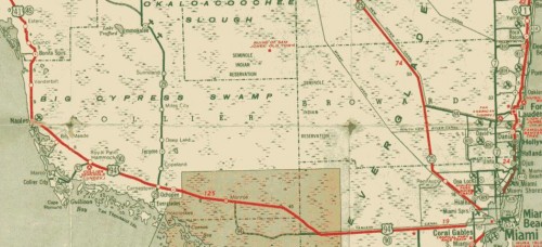
| US 1 has been around since the earliest planning stages, it is in the 1925 BPR plan. In 1927, it entered the state south of Folkston, GA. It was routed through Jacksonville, St. Augustine, Daytona, Titusville, Melbourne, Fort Pierce, West Palm Beach, and ended in Miami at US 94. The original route largely followed the east or "main" leg of the Dixie Highway. Heading south, US 1 followed a route close to its current alignment till US 23 leaves it. The route of US 23 into Jacksonville, "Old Kings Rd", is the original US 1. The name seems to change to State St in downtown Jacksonville. Main St, then as now, carries US 1 south to the Saint John's River. Across the river, a jog over St. Johns Ave lead back to the straighter route south, Hendricks Blvd. (Now FL 13). The route moved back east from Goodbys over Old St Augustine Road to join with the current alignment at Bayard. By 1935, US 1 was a straight shot between South Jacksonville and Bayard. The route through St. Augustine has been Bus US 1 since the 1960's. At Korona, US 1 took an eastward bend from current routes along Old Dixie Highway, following that south to Ormond Beach. US 1 followed a more coastal route earlier on, staying on Scenic Dr/Beach St/Riverside Dr/Beach St till Bellevue Ave, where it jogged west to current Ridgewood Ave. US 92 used to start here. In New Smyrna Beach, US 1 entered the city on Orange St, then turned left on Canal St, then back right along Magnolia. CR 515, Old Dixie Highway, from Willimas Point to Bonaventure was probably not US 1. Likewise, Old Dixie Highway from Valkaria to Shell Pit Pt is not likely to have been signed US 1. At Shell Pit Pt is an oxbow signed Old US 1. In Cocoa, US 1 did run along Ridgeway Ave and Florida Ave briefly. Current CR 605 through Oslo may have briefly been US 1 (An Old Dixie Highway), as may have CR 707 through Jensen Beach (Another Old Dixie Highway). FL A1A from Stuart to Jupiter Island may have been US 1 in 1926 or 1927. By 1928, US 1 / Federal Way was built. US 1 in Fort Lauderdale followed the route marked 'Dixie Highway' which also was Broadway south to a possible one-way pair with Poinsettia between 59th St and 23rd St. Poinsettia carries the highway south to 12th St, then there is a possible one-way pair with Olive Ave south to Belvedere Rd, where Poinsettia carries the Dixie Highway to the city limits. In Delray beach, Fifth Ave carried US 1. Another place the Dixie Highway diverged was along what is now FL 811 from Boca Raton to Ft. Lauderdale, with the new US 1 taking the current and more coastal route. US 1 entered on what was NE 10th St, and went south on the then named SE 6th Ave. In Hollywood, US 1 followed the east Dixie Highway, same as it does now. In Hallandale, the alignment makes a westward jog to what is now FL 5A. US 1 passed through 'Fulford' (North Miami). The Miami original terminus is much the same as it was, but the streets had different names. NE 6th Ave as it enters the city, NE 3rd Ave south to SE 1st St, and the Courthouse, where US 94 also ended. By the late 1930's, US 1 was routed over FL 4A (now FL 905) (Card Sound Road) south of Florida City to the Florida coast while the newer alignment was under construction. During the late 1920's, Florida's State Road department set out to run a highway to Key West, paralleling the famed Florida East Coast "Overseas Railway". Ferries were used to bridge the gaps in this new "Overseas Highway". No Name Key was the southern ferry port as the road moved slowly southward. After the Great Hurricane of 1935 closed down the Key West line, the state road department bought the old rail bed. During the Second World War, some of the existing railroad bridges to Key West were converted to automobile traffic to complete the highway. Most of the original railroad bridges are still in existence alongside US 1. West of Bahia Honda Key is a steel truss bridge that was too narrow for conversion to a two-lane road. The Bahia Honda channel was also an unfinished link in the Overseas highway, so the State Road Department built a two-lane road over the top of the trusses. The old bridge has a sign warning small craft that debris may fall from the crumbling concrete highway. It is in poor shape. Many of the existing rail bridges out to Key West were widened, like the famous Seven-Mile Bridge. Older alignments of this road are still signed "Dixie Highway" or "Old Dixie Highway". Pre-1946 State Road numbers: FL 4 State Line to Miami, FL 4A south of Miami. | |||
 |
US 17 | From 1926 to the present | AutoTrails: Dixie Highway (East),
St. Augustine Road, Lee-Jackson Highway, Central Florida
Highway, Dixie Highway (West), Orange Blossom Trail To US 17 pictures & information |
 The original route into
Florida was in the 1925 BPR plan, but under a different
number: US 21. In 1927, US 17 entered the state south of
Kingsland, GA, and terminated in Jacksonville on Main St
In a multiplex with US 1. In 1932, it
was extended south along Riverside Dr / St. Johns Ave in
Jacksonville (Now FL 211) to Green Cove Springs, Palatka,
Deland, Sanford, Orlando, Taft, Kissimmee, Haines City,
Winter Haven, Bartow, and Arcadia to end in Punta Gorda.
In Jacksonville, the alignment changed to a more inland
route in 1949, the original route briefly was signed Alt
US 17. CR 209 along the St. John's River was never US 17,
but it used to be old FL 3 and the Lee-Jackson Highway.
Old US 17 took a more circuitous route from near Pomona
Park to south of Crescent City. This route is currently
on street signs as "Old U.S. Highway 17". Old
FL 3 crossed the railroad tracks north of Pierson at
Connersville, and is now signed Volusia County Rd 3. This
probably was shielded US 17 south to DeLeon Springs,
where the current US 17 is rejoined. US 17 is co-signed
with US 92 from Deland, though
Orlando, to Haines City. See the US 92
history for this route, particularly the Orlando changes.
In 1932, US 17 south of Haines City followed current US 27's alignment south to a curve at
the current FL 544 intersection. FL 544 (Lucerne Park
Rd.) was followed to CR 554 (Old Lucerne Park Rd.) then
CR 554 back to FL 554 south of Lake Rochelle, passing
through the Florence Villa area before rejoining current
US 17 at Sixth St. A short jog at or near Cypress Gardens
Blvd put the road on 7th St to Eloise. Between Eagle Lake
and Bartow, US 17 followed Old Eagle Lake-Bartow Road. In
Bartow, it followed Broadway Ave. (Now US
98 /Bus US 98) to Main St (Bus US 98) then down
Orange Ave, or it may have just continued down Broadway
to Hooker St, then under the old ACL underpass (since
removed). From there US 17 picked up Kissengen Avenue,
following it past Hack Lake, then south of Bartow to
Homeland. The old road south from Homeland dead-ends at a
CSX railway overpass. Pembroke was on US 17 as well, now
the roads to it form an oxbow, and the town site has been
absorbed into Ft Meade. Original US 17 was routed on
Bowling Green- Ft Meade Rd. A newer roadway was built
within a few years. In the 1950's, that portion of US 17
was abandoned in place, and a newer roadway was
constructed along side, This allowed for the construction
of a new railroad overpass at a deadly semi-blind
crossing. The original 1930's crossing now sits on
private property and has been partially strip-mined,
removing part of the old road. The ghost roadway that
remained along US 17 torn up in the late 1990's to allow
US 17 to be expanded to 4 lanes. In North Wauchula, US 17
took a more direct route south on current CR 35A. This
road is still signed "Dixie Highway" in places.
US 17 followed current FL 64 back to its current
alignment at Zolfo Springs. US 17 in Wauchula was shifted
to the current alignment in 1938. The 1932 terminus in
Punta Gorda is now the westbound lanes of the US 17
one-way pair. US 17's alignment in Punta Gorda was
adjusted in 1985 with the arrival of I-75, "Old
US-17" is marked on street signs up to the
superhighway. Pre-1946 state numbers for its alignments
were FL 3 to DeLand, FL 21 to Orlando, and FL 2 south to
Arcadia, FL 68 to the end at Punta Gorda. The original route into
Florida was in the 1925 BPR plan, but under a different
number: US 21. In 1927, US 17 entered the state south of
Kingsland, GA, and terminated in Jacksonville on Main St
In a multiplex with US 1. In 1932, it
was extended south along Riverside Dr / St. Johns Ave in
Jacksonville (Now FL 211) to Green Cove Springs, Palatka,
Deland, Sanford, Orlando, Taft, Kissimmee, Haines City,
Winter Haven, Bartow, and Arcadia to end in Punta Gorda.
In Jacksonville, the alignment changed to a more inland
route in 1949, the original route briefly was signed Alt
US 17. CR 209 along the St. John's River was never US 17,
but it used to be old FL 3 and the Lee-Jackson Highway.
Old US 17 took a more circuitous route from near Pomona
Park to south of Crescent City. This route is currently
on street signs as "Old U.S. Highway 17". Old
FL 3 crossed the railroad tracks north of Pierson at
Connersville, and is now signed Volusia County Rd 3. This
probably was shielded US 17 south to DeLeon Springs,
where the current US 17 is rejoined. US 17 is co-signed
with US 92 from Deland, though
Orlando, to Haines City. See the US 92
history for this route, particularly the Orlando changes.
In 1932, US 17 south of Haines City followed current US 27's alignment south to a curve at
the current FL 544 intersection. FL 544 (Lucerne Park
Rd.) was followed to CR 554 (Old Lucerne Park Rd.) then
CR 554 back to FL 554 south of Lake Rochelle, passing
through the Florence Villa area before rejoining current
US 17 at Sixth St. A short jog at or near Cypress Gardens
Blvd put the road on 7th St to Eloise. Between Eagle Lake
and Bartow, US 17 followed Old Eagle Lake-Bartow Road. In
Bartow, it followed Broadway Ave. (Now US
98 /Bus US 98) to Main St (Bus US 98) then down
Orange Ave, or it may have just continued down Broadway
to Hooker St, then under the old ACL underpass (since
removed). From there US 17 picked up Kissengen Avenue,
following it past Hack Lake, then south of Bartow to
Homeland. The old road south from Homeland dead-ends at a
CSX railway overpass. Pembroke was on US 17 as well, now
the roads to it form an oxbow, and the town site has been
absorbed into Ft Meade. Original US 17 was routed on
Bowling Green- Ft Meade Rd. A newer roadway was built
within a few years. In the 1950's, that portion of US 17
was abandoned in place, and a newer roadway was
constructed along side, This allowed for the construction
of a new railroad overpass at a deadly semi-blind
crossing. The original 1930's crossing now sits on
private property and has been partially strip-mined,
removing part of the old road. The ghost roadway that
remained along US 17 torn up in the late 1990's to allow
US 17 to be expanded to 4 lanes. In North Wauchula, US 17
took a more direct route south on current CR 35A. This
road is still signed "Dixie Highway" in places.
US 17 followed current FL 64 back to its current
alignment at Zolfo Springs. US 17 in Wauchula was shifted
to the current alignment in 1938. The 1932 terminus in
Punta Gorda is now the westbound lanes of the US 17
one-way pair. US 17's alignment in Punta Gorda was
adjusted in 1985 with the arrival of I-75, "Old
US-17" is marked on street signs up to the
superhighway. Pre-1946 state numbers for its alignments
were FL 3 to DeLand, FL 21 to Orlando, and FL 2 south to
Arcadia, FL 68 to the end at Punta Gorda. |
|||
 |
US 19 | From 1929 to the present | AutoTrails: Gulf Coast Highway,
Mississippi River Scenic Highway, Dixie Highway Tampa
Loop To US 19 pictures & information |
| Did not enter the state in 1927. In 1929 it was extended to Florida, entering the state at Iamonia. It followed what is now US 319 into Tallahassee, including current FL 61, ended in front of the old Capitol building. In 1932, US 19 was extended along current US 27 to Capps, Perry, and Chiefland, where the route jogged east to Williston. It multiplexed with US 41 to Brooksville. US 41 went west on FL 50 to Aripeka, then south on the current alignment. In 1938, Alternate US 19 was added, possibly because of construction near Aripeka. Alt US 19 went south to Gowers Corner, and then followed current FL 52 to Bayonet. The roads rejoined, then followed current Alt US 19 though Anclote, Dunedin, Clearwater, Largo, and Seminole, ending at the St. Petersburg City Hall. The entry into the state changed in 1933, entering between Thomasville, GA and Monticello, running though Monticello on its way to Capps. By 1946, it was shifted to its current alignment between Chiefland and Bayonet. Its route in Pinellas County (St. Petersburg) started to be changed in 1951. That year the route changed, shifting US 19 to FL 55 south to FL 60, and west on FL 60 to current Alt US 19. In 1953, US 19 changed again, extending south along the route that was then FL 693 /Haines St. This road is now FL 55 / Eisenhower Blvd. A new route between Four Corners and Lealman (At Haines Rd.) was proposed in 1952. By 1953 this was US 19. A TEMP US 19 extended down FL 689 / Haines Rd & 9th St. N to 5th Av. N. Alt US 19 met it at this point. US 19 was extended over Tampa Bay to its final terminus in Memphis over the single-span Sunshine Skyway Bridge in September 1954. TEMP US 19 was decommissioned and US 19 was routed down 34th Street, where it remains. A second span across Tampa Bay was opened in 1971, for a total of four lanes. The Summit Venture knocked down this second span in 1980. The new Sunshine Skyway was opened to traffic April 30, 1987. The center spans have been removed from the original Sunshine Skyway. The remaining potions are in use as fishing piers. There was talk of truncating US 19 in St Petersburg as the Sunshine Skyway corridor was upgraded to I-275, but civic pressure from Bradenton nixed that idea. The original pre 1946 state road numbers for US 19 was FL 10 from Iamonia to Tallahassee, FL 500 (Very Old FL 19) to Williston, FL 5 south to Brooksville, and FL 15 for the remainder. | |||
 |
US 23 | From 1950 to the present | AutoTrails: Dixie Highway Connector To US 23 pictures & information |
| Was extended to Florida by 1950. When US 23 was first arrived in Florida, It was completely multiplexed with US 1. When US 1 was shifted to a newer alignment to the north in the early 1960's, US 23 was left behind on Old Kings Rd. There may have been a proposal in 1964 to extend US 23 south, possibly to Fort Myers along FL 19, FL 33, US 17, and FL 31. US 23 never had an old State road number, but is on the route of old FL 4. | |||
 |
US 27 | From 1934 to the present | AutoTrails: Old Spanish Trail,
Dixie Highway (west), St. Augustine Road, Tamiami Trail,
Mississippi River Scenic Highway, Central Florida
Highway, Scenic Highway, Okeechobee Road To US 27 pictures & information |
| Did not originally enter Florida. Extended to Florida in 1935, ending in Tallahassee. US 27 was being extended to Miami in 1949 via Perry, High Springs, a multiplex with US 441 to Leesburg. A Temp US 27 ran south of Leesburg to Polk City on current FL 33, then it followed FL 557 to US 17 in Lake Alfred. Temp US 27 followed US 17 to FL 540, then over to the former Alt US 27 (FL 17) in Waverly. Temp US 27 followed that road south till its current junction with US 27 south of Frostproof. In 1952, Temp US 27 was truncated to Haines City, following the former Alt US 27 to south of Frostproof. By 1957, Temp US 27 was still being used from Haines City south to Lake Wales, following FL 60 back to its newly paved and widened alignment. US 27 runs though Avon Park, Clewiston, South Bay, and Hialeah till its terminus at US 1 in Miami. Its original routes were FL 58 from the state line at Darsey to Havana and FL 1 from Havana to Tallahassee. The pre-1946 numbers for the rets of the route were FL 500 (VO FL 19) to Perry, FL 5A to High Springs, FL 2 to Leesburg. There was no road between Leesburg and Haines City. FL 8 / FL 8A was followed south from there to Lake Placid, then FL 67 was followed to Moore Haven. FL 25 was the next route number, and was followed to South Bay. By the late 1930's and early 1940's, FL 26 was built from the shores of Lake Okeechobee to Miami. | |||
 |
US 29 | From 1935 to the present | AutoTrails: "Old" Palafox
Hwy, Old Spanish Trail To US 29 pictures & information |
| Did not enter Florida in 1927, its current route in this state was assigned US 331 in 1926. US 29 and US 331 were co-signed on this route in 1935 and 1936. In 1937, this route was only US 29, and its routing has not changed significantly since then. The original pre-1946 State road number was FL 7. | |||
 |
US 41 | From 1926 to the present | AutoTrails: Central Florida
Highway, Bee Line Highway, Florida Short Route, Tamiami
Trail, Dixie Highway (west), Mississippi River Scenic
Highway To US 41 pictures & information |
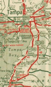
| US 41 has been around since the earliest planning stages, it is in the 1925 BPR plan. The original US 41 in 1927 entered Florida north of Jennings, then to Jasper. In Lake City, US 41 was first routed down from near the I-10 interchange down CR 25A to Marion St, currently US 441. In High Springs the original route probably came into town on NW 9th St, then used 1st Ave (Current US 27) to return to the current alignment. From here, current US 441 runs on US 41's original alignment. Around 1938, US 41 was moved further west, running though Newberry and Williston. Original US 41 entered Gainesville on Alabama St (Now FL 20 - NW 6th St and NW 5th St.), jogged east on Boundary St (now NW 8th Ave) to Main St. US 41 turned right on University, and followed it west to Old Ninth St, which is now SW 13th St and current US 441. Of minor interest, SW 2nd Ave was Masonic St. in Gainesville in 1928. US 41 followed current CR 25A through Reddick to Ocala. The original alignment of US 41 between Reddick and Kendrick briefly was US 441, then Alt US 441 in the early 1980's. In Ocala, US 41 came down Magnolia St to Broadway Ave. US 41 went west on Broadway and US 441's original route continued south on Magnolia. US 41 followed current FL 40 west to rejoin its current route at Juliette (Current Rainbow Springs). The route in Dunnellon, Inverness and Brooksville has not changed since 1928. In Tampa, US 41 went down Nebraska all the way to Lafayette St (Current Kennedy / FL 60 & Bus US 41). This is probably where US 92 had its original western terminus. US 41 / US 92 went up 13th St to 4th Ave, and east out of town to a jog in Ybor City (37th St?) up to 7th Ave (Broadway / CR 574) to Orient (Park). Tampa has seen a big change from the original US 41 routing. In 1951, US 41 was routed south on Bayshore Blvd, following a more inland route southwards to Palmetto, where it rejoined its current alignment. The more coastal route was previously signed US 541. From there, US 41 went down the current US 301 through Riverview, Parish and Ellenton to Palmetto. In Palmetto, US 41 followed Elm St. (now 10th St) to Lemon Ave (now 8th Ave and Bus US 41) across the Manatee River. The original bridge is now a fishing pier on the north side. The original bridge abutment remains on the south, blocked off by a guardrail. In Bradenton, US 41 went down 10th St, turned right on Manatee Ave (current FL 64), then left on 14th St. US 41 went south along current Bus US 41 to rejoin with US 41. In Sarasota, US 41 took a different route through the center of town, Main St (FL 780). Old US 41 turned south at current US 301 to rejoin with US 41 at the current US 301 terminus. The original route of US 41 through Venice, is still marked Bus US 41 / Tamiami Trail. US 41 used to enter Englewood on current FL 776 and left on current CR 777, crossing the Myakka River and rejoining the current alignment. This was bypassed by 1931. In Punta Gorda, US 41 crossed over Charlotte Harbor on a bridge that connected to Nesbit Street, then went west on Marion Ave to Shreve Street, which it followed south to current US 41. In Fort Myers, the more recent old route of US 41 is now Bus US 41. The original 1920's Caloosahatchee River crossing of US 41 went west from Business US 41 on current FL 78 to Old Bridge Rd in N. Ft. Myers across to Freemont St in Fort Myers. US 41 followed current FL 80 back to current US 41. A mapo in the 1927 Rand McNally Atlas shows US 41 ending in Fort Myers. The bend in old US 41 at Bonita Springs has been replaced by CR 887, still called "Tamiami Trail" and signed on street signs as "Old 41". US 41 originally ended at US 94 in Naples. In 1950, US 41 was extended east to Miami via the road formerly numbered US 94. In 1953, the final extension of US 41 occurred, with US 41 being extended to Miami Beach on FL A1A. The pre 1946 State Road numbers for US 41 were FL 2 from the State line to Ocala, FL 16 from Ocala to Dunnellon, FL 5 from Dunnellon to Fort Myers, and FL 27 Fort Myers to Naples (and FL 27 across to Miami). | |||
 |
US 90 | From 1926 to the present | AutoTrails: Old Spanish Trail, Lone
Star Trail, Bee Line Highway, Florida Short Route, St.
Augustine Road, Mississippi River Scenic Route To US 90 pictures & information |
| US 90 has been around since the earliest planning stages, it is in the 1925 BPR plan. The original 1927 routing started in Jacksonville at the intersection with US 1 / US 17 (Main St) and Adams St, US 90 took Broad (or Myrtle?) up to Beaver St, leaving town. US 90 has not changed through Lake City, Live Oak or Monticello. A 1927 alignment went through Lloyd and Chaires, and then headed into Tallahassee on current US 27. Around 1929, the current road into Tallahassee had been built, Mahan Dr / Tennessee Ave and the old route bypassed. As late as 1942, US 90 was still on its original route north on Monroe St in Tallahassee up to Havana. This is now US 27. US 90 then went back to its current alignment via current FL 12. US 90 used to enter Quincy on King St (FL 12), and then turned left on Madison (FL 65), heading south to Jefferson Ave. US 90 followed Jefferson Ave west out of town. In Sneads, US 90 may have followed the route of "Old Spanish Trail" In Marianna, US 90 stayed on LaFayette St, and left town heading west on Cottondale Hwy (now FL 10A). US 231's original alignment ended here. Then as now, US 90 passed through Chipley and Bonifay, staying on Nelson Ave in De Funiak Springs. In Milton, US 90 used to enter town on Walnut St (now called Caroline?) and went around the courthouse (on Willing or Elmira, the map is unclear) to Oak St, then US 90 turned south on Canal St, then headed west along Old US 90 to rejoin US 90's current alignment. US 90's route into Pensacola was Davis Hwy, which is now FL 291. Old US 90 probably jogged west on current FL 295 to Palafox St / US 331 (now US 29). US 90 turned west again onto Jackson St, and then shifted a block up Petersen St to Gadsden St, which was followed back to current US 90. US 90 entered Alabama over the Nunez bridge. US 90 was extended east to Jacksonville Beach by 1950. Routing in Florida has not had a major change since 1950. This was the pre-1946 FL 1. | |||
 |
US 92 | From 1926 to the present | AutoTrails: Lee-Jackson Highway,
(South) Atlantic Coastal Highway, Central Florida
Highway, Dixie Highway (west)(Tampa Loop), Memorial Blvd To US 92 pictures & information |
| US 92 has been around since the earliest planning stages, it is in the 1925 BPR plan. In 1927, US 92 ran from US 1 in Daytona Beach westward on Bellvue Ave / Deland Rd to rejoin with current US 92 near the I-95 interchange. The original road probably went through what is now Daytona International Airport. US 92's original alignment left current US 92 near Deland Highlands, entering Deland on Old Daytona Rd. In De Land, US 92 has been on Woodward Blvd. A multiplex with US 17 was signed from Deland southward starting in 1932. Instead of the lakefront route US 17 / 92 has through Sanford now, US 92 initially went due south in the Lake Monroe area on Elder Rd (or maybe Upsala Rd) to 1st St, now also known as FL 46. US 92 turned right on Park Ave in Sanford, and rejoined current US 17 / 92 south of town. The route through Orlando was circuitous. US 92 left its current routing at Lawrence Ave in the Winter Park Area. The road turned right at the lake, becoming E. Park Ave. At Fairbanks, US 92 turned right, then left onto Orange Ave. At Colonial Dr., original US 441 joined and ended. From Livingston Ave south past Lake Lucerne, there was a one-way pair with Main St. This ended at Gore Ave, and traffic went southward from there on current CR 527 (was FL 527) through on Kuhl Ave through Taft to rejoin current US 17 / 92 / 441 at Kissimmee. A new route was under construction south of Orlando in 1937, extending Kentucky Ave south to Kissimmee. Sometime in the 1940's, this was completed and given the name from the newer alignment of US 441 north of Colonial Blvd, Orange Blossom Trail. In Kissimmee, US 92 came down Main St. At Neptune Rd, US 192 began and left US 92. Current US 441 leaves US 17 / 92 with US 192. US 92 turned onto Broadway, then followed Emmett St to Clyde Ave, then another turn from Clyde Ave to Penfield Ave, then to Bermuda Ave., and finally out of town on Clay St. This route was CR 531, and is now just an unnumbered Old Tampa Highway to a junction with US 17 / 92 near Reedy Creek. After crossing Reedy Creek, to get back to the old road, you need to drive out CR 532 (Polk-Osceola Co. Line Rd.) to Old Tampa Highway on the left. The mile left of the road in Osceola County is a historical gem. The original brick pavement from the 1920's is still in place. (See my photo page.) Crossing the Polk County Line, the road becomes Kissimmee Rd, with modern asphalt and shoulders. Old US 92 jogged up CR 54 in Loughman, and went south on CR 547 to Davenport. US 92 entered Haines City along current Lee-Jackson Highway to 12th St, and then crossed over the railroad to 10th St on a viaduct. At Hinson Ave, US 92 turned right, turning left back onto the older auto trail, Lee-Jackson Highway. The original alignment of US 17 leaves the multiplex here. Old Lee-Jackson was followed to Lake Alfred. In Lake Alfred, the road went south from Old Haines City -Lake Alfred Rd down Experiment Station Rd, across current US 17/92 to Lee-Jackson, then west on Mobley, then south on Ramona to current US 17/92 then left on Seminole Ave to Pierce St, which US 92 followed out of town. US 17 currently leaves US 92 in Lake Alfred. US 92 used to enter Auburndale on Lake Alfred Rd, then south on Bartow Ave (SR 559)(now Main St) to W Park St, then across downtown on Pilaklakaha Ave, up Pearl St to Lake Ariana, and around the southwest side of the lake to current Old Dixie Highway. US 92 followed that route south, crossing what would be the eventual routing at Carter's Corner. By 1938, the current Haines City to Carter's Corner to alignment was constructed. US 92 followed CR 542 into Lakeland, connecting to Main St (Was Bus US 92). West of Lakeland, US 92 followed Old Tampa Highway (CR 542) to Youmans. The last leg of US 92 into Tampa followed current FL 574, taking Reynolds St out of Plant City, passing through Dover and Mango to Martin Luther King Jr. St. (Was Buffalo Ave.), then to Broadway Ave (now CR 574), following the old route of US 41 through Ybor City to the probable western terminus at the Hillsborough County Courthouse on Lafayette St (now Kennedy Ave). By 1932, US 92 was starting to be realigned, the roads appears to be on its current alignments from west of Plant City to its terminus in Tampa. The 1934 map of Florida shows US 92 and US 541 multiplexed down Florida Ave, with US 92 ending at Lafayette St. (Now FL 60) By 1936, US 92 was on its current alignment from Auburndale to Lakeland, and US 92 ended at US 41 / Nebraska Ave. In 1942, US 92 was routed to the coast, over the top of Tampa Bay along current FL 580 to end at US 19 in Dunedin (Per Dan Moraseski). This extension did not last, and by 1946 the extension of US 92 was planned again, with its new 'hidden' number was assigned to the roads over to and across the Gandy Bridge to St. Petersburg. US 92 terminated at US 541 in 1946. US 92 was not extended to St. Petersburg till 1953, when it terminated at the Pinellas County Courthouse with US 19. The route became Alt US 19 with the opening of the Sunshine Skyway in 1954, and is now FL 595. The pre 1946 State road numbers for US 92 were FL 22 from Daytona Beach to Deland, FL 3 to Orlando, FL 2 to Haines City, FL 17 to Tampa. | |||
 |
US 94 | From 1926 to 1950 | AutoTrails: Tamiami Trail, Dixie
Highway (west), Mississippi River Scenic Highway To US 94 pictures & information |
| US 94 has been around since the earliest planning stages, it is in the 1925 BPR plan. US 94 was one of the original 1927 routes, from US 41 in Naples to US 1 in Miami. The construction of this section of the Tamiami Trail across the Everglades was considered a major engineering feat. US 94 was little more than a very muddy trail till 1928. US 94's entire routing was absorbed by US 41 in 1951. A mapo in the 1927 Rand McNally shows US 94 starting in Fort Myers, the same place old State Road 27 began. US 94 never extended to Miami Beach like current US 41. This map shows US 94 from Naples to Miami. Neither Dade or Collier County Road 94 was ever US 94. | |||
 |
US 98 | From 1934 to the present | AutoTrails: Gulf Coast Highway, Bee
Line Highway (spur), Mississippi River Scenic Highway,
Central Florida Highway, Dixie Highway (west), Conners
Highway (Toll) To US 98 pictures & information |
| Originally US 98 ran from Apalachicola to McNeils, Port St. Joe, Panama City, Westbay, Ebro, Freeport, Portland, Niceville, Camp Walton (Ft. Walton Beach), and Esther, then to up Pensacola (Toll Bridge). US 98 was moved to a more coastal route between Panama City and Ft. Walton Beach in 1935, the 1934 alignment around Chocotowatchee Bay looked like this.A route was signed north of Navarre, then up to US 90 at Milton along current FL 87, and followed US 90 to US 98's terminus of that time in Pensacola. This US 98 was retired by 1946 when the tolls were removed. By 1946, US 98 was rerouted south of Choctawhatchee Bay along the coast though Destin. US 98 has been realigned away from McNeils on FL 30 by construction of a newer road between Apalachicola and Port St Joe. US 98 was extended eastward to West Palm Beach in 1952. Temp US 98 (leg one) ran from Wakulla up to Tallahassee, and then multiplexed with US 27 east to Perry, during construction of the direct Wakulla to Perry Route. This route was decommissioned in 1954. Temp US 98 (leg two) ran along the current routing of US 98 from Okeechobee south to West Palm Beach, and the section from Canal Point to West Palm Beach was still Temp US 98 in 1959. The TEMP signs near West Palm Beach were removed in the early 1960's. The original routing of US 98 followed current Business routes in Panama City, Dade City, Lakeland, and Bartow (currently unsigned). Other original sections of US 98 include Lake Hollingsworth Rd, around the NE side of Lake Hollingsworth, and back to US 98 on Crystal Lake Dr. This route was in place from 1952 and past 1957. On the North side of Bartow, another original US 98 route went down what is now E.F. Griffin Rd, and headed east on what is now Lyle Pkwy till the late 1950's. This route was known as Old Lakeland Rd as late as 1986. US 98 was extended west into Alabama in 1955. Its original State road number along the Panhandle Gulf coast was 53. In 1947, its alignment looked like this. | |||
 |
US 129 | From 1941 to the present | AutoTrails: In Branford: Dixie
Highway (west), St. Augustine Road To US 129 pictures & information |
| Did not enter Florida in 1927. US 129 extended to Jasper in 1941, and was extended to Old Town in 1948 along current FL 349 from Branford. In 1959, current FL 349 to Old Town was re-signed as Alt US 129, and the southern terminus of US 129 was changed to Chiefland, routed along FL 49. Temp US 129 signed were placed on current US 129 / FL 249 in 1959, by 1962, the routing had officially shifted, and the original US 129 signs were removed. Alt US 129 to Old Town was decommissioned in 1971. The pre-1946 number was FL 50. | |||
 |
US 192 | From 1926 to the present | AutoTrails: Dixie Highway
(connector) To US 192 pictures & information |
| US 192 has been around since the earliest planning stages, it is in the 1925 BPR plan. The 1927 routing of US 192 started in Kissimmee at US 92, and ended in Melbourne at US 1, a 56-mile long road. Around 1932 the route was re-aligned from east of Deer Park to east of St. Cloud. Near Ashton a dead end section of Old Melbourne Highway remains along the older alignment, ending at a locked gate next to the private Lake X Airstrip. North of Holopaw, a short section of the original 1920's era brick highway remains, and the gate north of Holopaw is usually open. I believe the brick section is now private land, used to service the local ranch(es). Any other remaining pavement from the original highway is overgrown and behind closed gates. The online sattelite photo services show a trail remaining along the old roadbed. The western terminus was extended to intersect US 27 between Clermont and Haines City in 1972, cutting though the property of recently opened Walt Disney World. US 192 originally began in Kissimmee on CR 525 (Neptune Rd, old FL 525), and then jogged up to the current US 192 / 441 near Fish Lake. US 192 entered Melbourne then as now on New Haven Ave. US 192 was extended to Indialantic in the late 1960's. The original pre-1946 state road number was 24. | |||
 |
US 221 | From 1954 to the present | Auto Trails: St. Augustine Road,
Dixie Highway (west), Mississippi River Scenic Highway To US 221 pictures & information |
| Was extended into Florida at Ashville to Perry from Quitman, GA in 1954. It terminates at US 19 / US 98 / US 27A The alignment has not changed since then. | |||
 |
US 231 | From 1926 to the present | AutoTrails: Bee Line Highway To US 231 pictures & information |
| US 231 has been around since the earliest planning stages, it is in the 1925 BPR plan. The 1927 road entered Florida north of Campbellton and went straight to Marianna, meeting US 90 and terminating at Lafayette St. In 1935, the highway had been rerouted to its current terminus at Panama City. Its original route in Florida was old FL 6, it was extended down old FL 20 to the Gulf of Mexico. | |||
 |
US 301 | From 1948 to the present | AutoTrails: Dixie Highway
(connector), Central Florida Highway, Tamiami Trail To US 301 pictures & information |
| US 301 did not exist in 1927, even though US 201 did in Maine, and US 401 did in Virginia. US 301 had been reserved in 1925 for a portion of what became US 17 in Virginia. By 1932, the number had been added the US highway system. It did not extend to Florida till 1948. US 301 ended up being signed on FL 200 to Ocala, and then it followed FL 35 to Dade City, FL. It picked up FL 39 to Zephyr Hills, and then followed FL 41 to into Tampa where it terminated in 1949. This route still exists from Thonotosassa to eastern Tampa as Harney Rd, and from US 92 south as Lake Ave. In 1952, it was routed along the 'old' US 41 routing south to Palmetto (SR 43). In 1953, US 301 was extended to its final terminus at Sarasota. It never had an old State Road number, but the old State Roads on its current alignment are FL 4 From the State line to Callahan, FL 13 to Waldo, FL 31 to Ocala, FL 2 to Belleview, FL 23 to Zephyrhills. | |||
 |
US 319 | From 1934 to the present | AutoTrails: Dixie Highway (west) To US 319 pictures & information |
| In 1934, US 319 was created. Its alignment looked like this. Like many other Florida US routes, it was entirely a intrastate route to begin with. US 319 's northern terminus was right in the heart of Tallahassee, on current FL 61 (Monroe St). From an intersection with US 19 the state capital steps, it proceeded south of Tallahassee on current FL 363, turning west at Wakulla. It followed FL 368 to join with current alignment at Crawfordville, ending at Eastpoint. US 319 was extended to its current southern terminus of Apalachicola when the Apalachicola Bay Bridge was built. Sometime around 1937, US 319 was extended north along the former US 19 route out of Florida up to Thomasville, GA. In 1975, US 319 was moved out to the eastern leg of the Capital Circle in Tallahassee (FL 261), its former alignment in town was signed Business US 319 briefly. Now it is just FL 61. US 319 was also re-routed south of Tallahassee to the more direct route to Crawfordville on FL 369. The old alignment was re-signed as its State Road numbers. US 319 now terminates at the foot of the John Gorrie Memorial Bridge. It followed old FL 10. | |||
 |
US 331 | From 1926 to 1936 | AutoTrails: None on
modern US 331 To US 331 pictures & information |
| US 331 | From 1954 to the present | ||
| The original 1926 highway was mostly located in Florida, having started just across the Alabama border at US 31 in Flomaton, going through Molino and Muscogee as it went south. US 331 left the current US 29 alignment near Molino Crossroads, traveling along CR 95A. From Ipsco to Brent, old US 331 followed current CR 595A into town. There was a multiplex with the original US 90 on Palafox Street to the Florida Square, which may have been the southern terminus. Another couple of possible south ends of US 331 are the courthouse, or Fort Barrancas. In 1935 and 1936, US 331 was multiplexed with US 29 after it was extended to Pensacola. By 1937, the road was only US 29, and US 331 was retired. The original US 331 followed old FL 7. It looked like this in 1934. | |||
| In 1954, US 331 was recommissioned, enteriing Florida at Florala, AL and going to US 98 near Santa Rosa Beach by way of DeFuniak Springs. US 331's hidden state highway number, FL 83, independently extends past US 98 to terminate at Blue Gulf Beach on the Gulf of Mexico. | |||
 |
US 441 | From 1926 to the present | AutoTrails: Woodpecker Route,
Florida Short Route, Central Florida Highway, Bee Line
Highway, Tamiami Trail, St. Augustine Road, Dixie Highway
(west), Lee-Jackson Highway, Dixie Highway (connector),
Conners Highway (Toll) To US 441 pictures & information |
| US 441 has been around since the earliest planning stages, it is in the 1925 BPR plan. US 441 was very short road, an 87 mile long highway from Ocala to Orlando via Leesburg and Eustis. It began on Magnolia Ave (now CR 464A) at US 41 in Ocala. As US 441 left town, it shifted to the west, going around the Ball Park to the current Pine St route. Original US 441 left current US 441 at Belleview, passing though Oklawaha on the east side of Lake Weir before rejoining the current alignment at Lady Lake. This alignment was signed Alt US 441 for many years, and is now FL 25. US 441 left the current alignment again in Leesburg, heading into town on 13th St, then east on Main St. (now FL 44) In Tavares US 441 followed Alfred St to Dora Ave, then Dora Ave up just above Lake Woodard. From there, US 441 went towards Mount Dora around the north side of Lake Gertrude, This alignment was bypassed by 1934 with a newly built direct alignment from Tavares to Mount Dora, which is now CR 500A, and signed Old US 441. US 441 departed current US 441 in Plymouth, following CR 424 through Apopka, US 441 used to enter on Orange St, turn right on Central, turn left on 4th St, then right on Buick Rd out of town, CR 424. CR 424 is also known as Apopka Rd and Niagra Ave as it enters Orlando. US 441 followed Colonial Drive (now FL 50) to its terminus at US 92 (Orange Ave) in downtown Orlando. The southern terminus was truncated in 1941 to the intersection of Colonial Drive and Orange Blossom Trail. The northern terminus was extended to High Springs over the former US 41 alignment in 1938. By 1949, the northern terminus had been extended out of state along the current alignments. In 1950, the southern terminus was extended to Miami, reaching the newly re-shielded US 41. The original State Road number for US 441 in 1927 (Ocala to Orlando) was FL 2. This is a map of US 441 in 1934. | |||
 |
US 541 | From 1932 to 1951 | AutoTrails: Tamiami Trail,
Mississippi River Scenic Highway To US 541 pictures & information |
| US 541 was commissioned in 1932, running from Tampa to Palmetto. In 1934, it started at the intersection of Florida Ave and N. Hillsborough Ave, and was multiplexed down Florida Ave with US 92. In 1934, it was extended north up what is now Business US 41 (Florida Ave)(Old SR 313) to Chapman (at US 41) in North Tampa from Lafayette St (SR 60)(Old SR 97)(Now Kennedy Ave). It went north from that up 13th St., then east on 4th Ave. At 22nd Street, one branch of the road turned south, An Alternate route continued on 4th Ave. Alt US 541 jogged up 30th Street onto Broadway Ave (Now Adamo / SR 60) , and followed it to the Bayshore Rd/50th St intersection. Alt US 541 turned south there, and rejoined US 541 at the intersection of Bayshore Rd and Causeway Blvd. US 541 followed the current alignment of US 41 south to Palmetto (Old SR 23), where it rejoined US 41. US 541 was decommissioned in 1951 in favor of Bus US 41 and a more direct route of US 41 south. A map of US 541 in West Central Florida is available, and an inset map of Tampa, showing the Alternate route. US 541 briefly had a 'Optional' Route (OPT) on the 22nd St. Causeway in 1936, this became mainline US 541. | |||
Information Sources:
Various Maps & Scans I have access to.
Books:
Skyway to the Sun
by Holly Waggoner, 1988
Florida Trails to
Turnpikes 1919-1964 by Baynard Kendrick, 1964
Automobile Blue Book
Vol 5, "Florida and Gulf Coast" 1929
Automobile Blue Book
Vol. 2 1925
Southeastern Tourbook
1940 by AAA
Other:
![]() Dave Schul's Auto Trails Page includes
named auto trails that existed in Florida, the precursors to the
US numbered highway system.
Dave Schul's Auto Trails Page includes
named auto trails that existed in Florida, the precursors to the
US numbered highway system.
1925 BPR Report on
Interstate Highways October 30, 1925
American Highways
April 1927, Vol. VI No. 2
Misc information and
other assistance: Dave Schul.
Thanks to the
following providers of information:
Hollis L. Carroll, FDOT;
Polk County Historical and Genealogical Library; Polk County
Museum; Tampa Public Library;, Orlando Public Library; AASHTO c/o
Donna Tamburelli; FHWA c/o Richard Weingroff; Bartow Public
Library; FDOT District One Records; Dave Schul; M. Steffora;
Merle F. McClelland
![]()
Other sites related to the history of Florida's highways
![]() My collection of maps with at least one historic Florida
map. (Hosted by Geocities)
My collection of maps with at least one historic Florida
map. (Hosted by Geocities)
 Tallahassee,
Then and Now, by Don Draughton (US 319, US 27, and
US 90 as they are and were)
Tallahassee,
Then and Now, by Don Draughton (US 319, US 27, and
US 90 as they are and were)
![]() Florida
Auto Trails Before the US highways, people
followed named auto trails as they went from town to town. The
paving was often poor, with bricks being the ultimate road
surface. There is more here about the Auto Trails listed above
Florida
Auto Trails Before the US highways, people
followed named auto trails as they went from town to town. The
paving was often poor, with bricks being the ultimate road
surface. There is more here about the Auto Trails listed above
Last update to this page on Thursday, May 23, 2002
![]() Click here
to E-mail me with additions, comments and corrections
Click here
to E-mail me with additions, comments and corrections