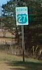
 US 27 / Alt US 27 US 27 / Alt US 27
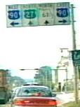
 North Florida
Lake Weir Polk Sebring
North Florida
Lake Weir Polk Sebring
|
US 27 | Length in state: 481 mi. |
| Termini: FL: State line near Darsey
to Jct US 1 in Miami US: (Mackinaw City, MI) Fort Wayne, IN to Miami |
Years: 1934 / present | |
| Route: US 27 enters the state north of Havana on four or more lanes, and passes through Tallahassee, turning south again at Capps, with a easterly jog at Perry, where the divided highway ends. From there, US 27 runs on two lanes to High Springs, then south to Ocala where it becomes a divided highway again. From there, US 27 is a multilane highway, and a favorite alternate truck route for I-75. US 27 passes southward through Lady Lake, Leesburg, Haines City, Lake Wales, around the western and southern shores of Lake Okeechobee, then through Hialeah. The last leg into Miami in a multilane undivided route parallel to the Airport Expressway, Toll FL 112. US 27 ends at a junction with US 1. | ||
| Counties: Gadsden, Leon, Jefferson, Madison, Taylor, Lafayette, Suwanee, Columbia, Alachua, Marion, Sumter, Lake, Polk, Highlands, Glades, Hendry, Palm Beach, Broward, Miami-Dade | ||
| "Hidden" state numbers: FL 63 State line to Tallahassee, FL 20 Tallahassee to High Springs, FL 45 High Springs to Williston, FL 500 Williston to Leesburg, FL 25 Leesburg to Hialeah, FL 948 Hialeah to Miami | ||
| Co-signed with: |
||
| Drive: US 27 from Ocala
south is heavily used by truck traffic, as an alternate
to Florida's Turnpike and Interstates and has been
upgraded in the 1990's to a four lane divided highway as
far south as Miramar, FL. (7-5-99) The end of US 27 is marked with an END sign, and BGS's on US 1 point to US 27. After the first reassurance marker at the intersection of US 27 and US 1, there is one such marker at FL 9 and none at the intersection with US 441. The official state map shows this route as FL 948, but this marking is not present either. |
||


|
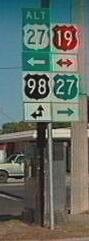
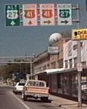
Alternate US 27 (North Florida) | Length: 94 mi. |
| Perry to Williston | Years: 1949 / present | |
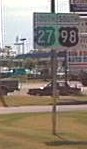
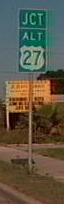
| Route: No major cites are on this route. It begins at a junction with US 19 / US 27 / US 98 in Perry. It passes thru the towns of Athena, Salem, Shamrock, Cross City, Eugene, Old Town, Chiefland, Bronson, to Williston, where it ends at a junction with US 27 / US 41. The multiplex with US19 / US 98 is multilane, and the rest of the route is two lanes. | ||
| Counties: Taylor, Dixie, Gilchrist, Levy | ||
| "Hidden" state numbers: FL 55 Perry to Chiefland, FL 500 Chiefland to Williston | ||
| Co-signed with: |
||
| Drive: The section from Perry to Chiefland is a four lane highway, with reasonable medians and little cross traffic. | ||
|
Alternate US 27 (Lake Weir) | Length: 17 mi. |
| Termini: Belleview to Lady Lake | Years: @ 1962 / 1980 | |
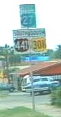
| Route: Originally the route for US 27 / US 441 around the east side of Lake Weir. Passed though Oklawaha, Eastlake Weir, and Weirsdale. It began at the junction with US 27 / US 441 and US 301 and ended at a junction with US 27 / US 441. The entire route is a two lane road. | ||
| Counties: Marion, Lake | ||
| "Hidden" state number: FL 25 | ||
| Co-signed with: |
||
| Drive: July 2001: You have to know what you are looking for, FL 25. After the FL 35 junction, this becomes CR 25 for the rest of the trip around the lake. Lake Weir is barely visible because of the size of the private property and the overgrowth on the lots. The speed limit is reduced in the small cities that dot the route. The was even a "Speed Zone Ahead" sign leading into Eastlake. The junction with US 27 / 441 is odd, you pass under the mainline on a right-of-way big enough for two more lane and a rail line and end up on the west side of the road. | ||

|
Alternate US 27 (Polk) | Length: 38 mi. |
| Termini: Haines City to Sunray Deli Estates | Years: 1949 / 1998 | |
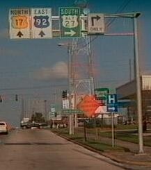
| Route: Was originally the Temporary Route for US 27 during construction of the new route, and signed as Alt by 1960. Haines City, Dundee, Lake Wales, Babson Park, Frostproof. Replaced by US 17 / US 92 / TO FL 17 in Haines City, and FL 17 for the remainder of its former route. Began at the junction of US 17 / US 92 and US 27, and ended at a junction with US 27 / US 98. The entire route is a two lane road, very twisty and turny and hilly. | ||
| County: Polk | ||
| "Hidden" state number: FL 17 | ||
| Co-signed with: Was |
||
| Drive: This is the old Temp US 27 alignment is also locally known as "Scenic Highway". SR 17 passes over some of the hilliest country you will find in peninsular Florida. (1/99) | ||
|
Alternate US 27 (Sebring) | Length: 12 mi. |
| Termini: Avon Park to Sebring Southgate | Years: 1949 / 1979 | |
| Route: Was originally a Temporary Route during US 27 initial construction, which was completed @1953. From Avon Park at a junction with US 27 / US 98, to Lakemont, Sebring, and ending in Sebring Southgate, back at US 27 / US 98. The entire road is two lanes wide. | ||
| County: Highlands | ||
| "Hidden" state number: FL 17 | ||
| Co-signed with: None | ||
| Drive: This route passed thru downtown Sebring, I have seen the characteristic green and white shields on a TV show about older Sebring races. | ||

![]() Click here to go back to Florida in
Kodachrome
Click here to go back to Florida in
Kodachrome
![]() Click here to go to the history of US 27 in Florida
Click here to go to the history of US 27 in Florida
Last update to this page on Monday, December 11, 2006