
 Florida Auto Trails
Before the U.S. Numbered Highway System was established
in 1926, inter-state traffic followed paths blazed and promoted by various
trails associations, a system collectively known as Auto-Trails. The Auto-Trail
System relied on dues paid by members along the route to pay for advertising. Improvement of the
route was left to locals. The markers used were
as colorful as some of the promoters. All
you really needed to run a auto trail was a
couple buckets of paint and a knack for self-promotion. Mapmakers tried
in vain to keep track of the various trails and trailmarkers. Trail markers
were occasionally posted as independent signs, but more often were posted by painting
them on utility poles, bridge abutments, and fence posts. If you
want a history of Auto-Trails and the routes they took nationally
(and Internationally in some cases) see Dave Schul's North
American Auto Trails, linked below.
This website is focused on the named Trails of Florida, based
heavily on a 1925 Rand McNally Map of Florida. The routes are
shown along the major highways (US and Florida state routes) that
replaced them in function, and directly in many cases. A more
detailed turn-by-turn route guide would make a good future
project.
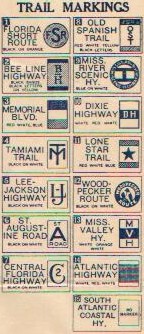 The map shows 14 named trails in
Florida, and one named Toll Road:
The map shows 14 named trails in
Florida, and one named Toll Road:
Atlantic Highway
Bee Line Highway
Central Florida Highway
Connors Highway
Dixie Highway
Florida Short Route
Lee - Jackson Highway
Lone Star Trail
Memorial Boulevard
Mississippi River Scenic Highway
Old Spanish Trail
St. Augustine Road
(South) Atlantic Coastal Highway
Tamiami Trail
Woodpecker Route
I have seen references to a "Gulf Coast
Highway", which may have stretched from Pensacola to St.
Petersburg along US 98 and US 19, but this was not on the map.
Mississippi Valley Highway was included in the above
graphic because the map showed Mobile, Alabama, a spur terminus
of that route.
The following trails may or may not have been posted in
Florida. Sources - Schul site, Library of Congress Archives
- Appalachian Scenic Highway, with a spur route
entering the state north of Lake City and a terminus in Marco, and a spur
route from that at Wildwood, terminating in Miami, with a connector from
Arcadia to Palm Beach
- Black Bear Trail, terminating in Miami
- Cleveland-Marietta-Asheville-Florida Highway,
terminating in Jacksonville after following US 1 from Waycross, GA
- Detroit-Asheville-Miami Highway (aka Lakes-to-Florida
Short Route), entering the state north of Lake City with a terminus in Miami
and a spur from Lake City to a terminus in Tampa
- Glacier Trail, entering the state between Dothan and
Tallahassee and terminating in Jacksonville or Miami
- Great Lakes - Atlantic Highway, terminating in Miami
- Great Lakes - Gulf Highway, terminating in
Apalachicola
- Henry Grady Highway, terminating in Fort Myers
- Jefferson Davis Memorial Highway, terminating in
Miami
- Lakes-to-Florida Highway, terminating in Jacksonville
after following US 1 from Waycross, GA
- Lakes-to-Ocean Highway, terminating in Tampa with a
spur to Miami
- Stonewall Jackson Highway, terminating in Tallahassee
References:
1924 Rand McNally AutoTrail map of the US (1999 reprint)
1925 Automobile Blue Book, Vol 6
1925 Rand McNally Junior Auto-Trail map of Florida
1929 Automobile Blue Book, Vol 5
1926 Rand McNally Road Atlas (1974 reprint)
2000 DeLorme Florida Atlas
2001 Rand McNally Atlas
Links:
North
American Auto Trails by Dave Schul - The best source for
information on Auto Trails.
 US Highways: From US 1 to (US
830)
US Highways: From US 1 to (US
830)
This page first posted to the web by Robert V. Droz on May 22,
2001
This page last updated Friday, November 09, 2001