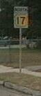
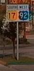
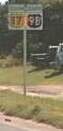
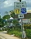
 US 17 / Alt US 17 /
Truck US 17 US 17 / Alt US 17 /
Truck US 17
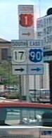
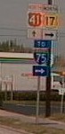
US 17 / Alt US 17 /
Truck US 17 US 17 / Alt US 17 /
Truck US 17
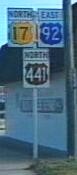
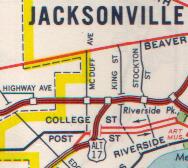
 Jacksonville South Jacksonville
  Orlando Kissimmee
|
US 17 | Length in state: 294 mi. |
| Termini: FL: State line near Gross
to Jct US 41 in Punta Gorda US: Winchester, VA to Punta Gorda |
Years: 1926 / present | |
| Route: Jacksonville, Orange Park, Palatka, Deland, Sanford, Casselberry, Maitland, Orlando, Kissimmee, Haines City, Winter Haven, Bartow, to Punta Gorda, where it ends at a junction with US 41. | ||
| Counties: Nassau, Duval, Clay, Putnam, Volusia, Seminole, Orange, Osceola, Polk, Hardee, Desoto, Charlotte | ||
| "Hidden" state numbers: FL 5 State Line to Jacksonville, FL 15 from Jacksonville to Orlando, FL 600 from Orlando to Lake Alfred, FL 555 from Lake Alfred to Bartow, FL 35 from Bartow to Punta Gorda | ||
| Co-signed with: |
||
| Drive: (4/99) From
Jacksonville to San Mateo, US 17 is a wide four lane
modern highway. From San Mateo to De Leon Springs, the
road is two lanes, a rural thruway. Multiple raised
pavement markers lift the highway stripes from the road
surface, helping to keep drifting drivers alert. From
DeLeon Springs to De Bary, the road is very old, a
suburban-urban highway. The road is four lanes, with and
without a median. From De Bary to Sanford, there is a
nice two-lane drive around the south side of Lk. Monroe.
From Sanford to Campbell, the road is highly urbanized,
with some semi-rural portions between Sky Lake and
Kissimmee. From Campbell to Haines City, the road is a
rural thruway again. From Haines City south to Wauchula,
the road is a modern four-lane highway, the ultimate plan
is to continue all four lanes south for the complete
route. From Wauchula to Punta Gorda, the road is still a
two-lane rural thruway. (2000) There is a new alignment for US 17 / 92 through Kissimmee, it follows the former "Truck Route", partially along US 192. The old route is now just city streets. (2006) Jacksonville decided to change US 17's routing through town, now it follows most of what was "Alt US 17" on state maps, up onto the Interstate. The old route was returned to the city. |
||
|
Alternate US 17 (Jacksonville) | Length: 1 mi. (Was 11.3 miles) |
| Termini: I-10 and US 17 in Jacksonville (Was Jct US 17 in Holly Ford area to Jct US 17 in Riverside area) | Years: 1961 / 2006 | |
| Route: Jct I-10 to Jct US 17 at Roosevelt Blvd along the "Roosevelt Blvd Connector". This route does not seem to be in the FDOT route logs as ALT US 17, but as US 17. It is shown on numerous maps, including the official state map. It is not in the AASHTO route log. I have a 1970 Standard Oil (Kentucky) map that shows this route starting at the junction of US 17 and Clark Road, then jogging over to I-95, then down to I-10, and finally along the Roovevelt Blvd Connector to US 17. | ||
| County: Duval | ||
| "Hidden" route numbers: FL 5A, FL 9A, FL 8, FL 15A | ||
| Co-signed with: Was
with |
||
| Drive: (2001) The
route's current form seems to end at I-10, not
reconnecting with US 17. Access along the route is
controlled (AASHTO calls it limited). The route has been
on maps for years, but FDOT signs it as TO I-10 and TO US
17. Any Alt US 17 signs were removed prior to 1993. It is
basically a long ramp. (2006) Route incorporated into mainline US 17. |
||
|
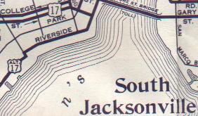
Alternate US 17 (South Jacksonville) (Decommissioned) | Length: 6.5 mi. |
| Termini: South Jacksonville to Ortega | Years: 1955 / 1956 | |
| Route: The original route of US 17 in south Jacksonville from 1932 to 1950. Riverside Dr from the Post St intersection south, continuing as the road changes names to St. Johns Ave and Herschel St. Alt US 17 jogged east on San Juan Ave, following the road along the coast as it changed names to Grand Avenue and finally to Ortega Blvd, and ended at an intersection with US 17 / Roosevelt avenue. | ||
| County: Duval | ||
| "Hidden" state number: FL 211 | ||
| Co-signed with: None known | ||
| Drive: The former route of US 17 along the St. Johns river is a twisting, turning route. | ||
|
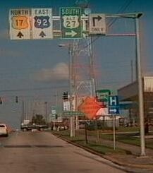
Truck US 17 (Orlando) | Length: 3.4 mi. |
| Termini: Jct US 17 / 92 in Maitland to Jct US 17 / 92 in Winter Park in the Orlando Area | Years: 1960's / present | |
| Route: This route leads from US 17 / 92 along CR 438A, which is Lave Ake in Maitland and Kennedy Ave in Eatonville, to a city street in the very shadow of I-4, Wymore Rd, which I don't think is state maintained, and returns to a Junction with US 17 / 92 along FL 423. | ||
| County: Orange | ||
| "Hidden" state numbers: CR 438A, FL 423 | ||
| Co-signed with: |
||
| Drive: (2001) Maps do not show this route, but it is pretty well maintained maintained and signed, and avoids a low rail trestle crossing US 17 / 92. | ||
|
Truck US 17 (Kissimmee) (Decommissioned) | Length: 1.6 mi. |
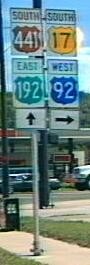
| Termini: Jct US 17/92/192/441 north of Downtown to Jct US 17 / 92 southwest of Downtown in Kissimmee | Years: 1980's / 1999 | |
| Route: Truck US 17 / 92 in this area used to avoid Kissimmee's popular downtown area. US 17 / 92 was moved to this route in 1999. US 192 is also known as Vine St and CR 525 is also Bermuda Ave. | ||
| County: Osceola | ||
| "Hidden" state numbers: FL 530 along US 192, CR 525 | ||
| Was co-signed with: |
||
| Drive: I liked driving through Downtown Kissimmee, but don't anymore now that US 17 / 92 was removed. I don't know why they did not pursue a Business designation, maybe they wanted more streetscaping.This new segment of US 17 / 92 is rather unremarkable. | ||

![]() Click here to go back to Florida in Kodachrome
Click here to go back to Florida in Kodachrome
![]() Click here to go to the history of US 17 in Florida
Click here to go to the history of US 17 in Florida
Last update to this page on Monday, December 11, 2006.
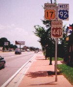
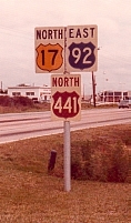
Older US 17 / 92 / 441 sign courtesy Edward J Mattes.