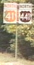
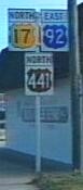
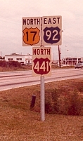
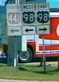
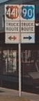
 US 441 / Alt US 441 / Bus US
441 / Trk US 441 US 441 / Alt US 441 / Bus US
441 / Trk US 441
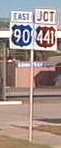
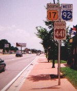
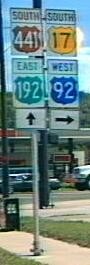
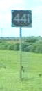
US 441 / Alt US 441 / Bus US
441 / Trk US 441 US 441 / Alt US 441 / Bus US
441 / Trk US 441
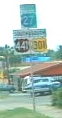
 Ocala
Lake Weir
Ocala
Lake Weir 
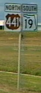
 Lake
City Leesburg Eustis
Lake
City Leesburg Eustis
|
US 441 | Length: 459 mi. |
| Termini: FL: State line north of
Benton to Jct US 41 in Miami US: Lake City, TN to Miami |
Years: 1926 / present | |
| Route: US 441 enters the state from Georgia on a two-lane road, I-75 handles most of whatever mainline traffic used it. US 441 is a four lane highway through Lake City, but goes back to being a two lane road until high Springs, an old northern terminus. US 441 is a major highway south from there, connecting Gainesville, Ocala, Lady Lake, Leesburg, Apopka, Orlando, and Kissimmee. From Ashton, west of St. Cloud, US 441 becomes a two lane road, passing through sparely populated areas along Florida's Turnpike and circling the north and east edges of Lake Okeechobee. East of Belle Glade it becomes a multilane road again, turning south towards Miami at Royal Palm Beach. The road is two lanes wide (for now) south from there, becoming a four lane facility south of FL 808. It is four lanes through Plantation and Davie, ending in Miami at an intersection with eastbound lanes of US 41. | ||
| Counties: Columbia, Alachua, Marion, Sumter, Lake, Orange, Osceola, Okeechobee, Martin, West Palm Beach, Broward, Miami-Dade | ||
| "Hidden" state numbers: FL 47 State line to Lake City, FL 25A in Lake City, FL 25 Lake City to Ocala, FL 500 Ocala to Holopaw, FL 15 Holopaw to Belle Glade, FL 80 Belle Glade to Royal Palm Beach, FL 7 Royal Palm Beach to Miami | ||
| Co-signed with: |
||
| Drive: (7-5-99) From Holopaw to Yeehaw Junction: The two-lane road has places where there are a few easily avoidable potholes. Aside from that it makes a decent alternate to Florida's Turnpike. The Desert Inn in Yeehaw Junction is a historic site and a former Sinclair gasoline station. There is a small museum upstairs (It takes a $1 donation to see it). | ||
|
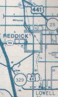
Alternate US 441 (Ocala) (Decommissioned) | Length: 14 mi. |
| Termini: Jct US 441 in Reddick to Jct US 301 / 441 in Ocala | Years: 1978 / 1981 | |
| Route: Found on a 1981 map of Ocala. It was a short lived route, following Gainesville Rd from US 441 near Reddick, FL through Lowell, Martin, Zuber and Kendrick, FL to rejoin US 301 / US 441 in north Ocala. This was the original route of US 441 in the area, and US 41 before that. | ||
| County: Marion | ||
| "Hidden" state numbers: CR 25A (was SR 25A, and SR 25 before that) | ||
| Co-signed with: None | ||
| Drive: July 2001: A rural area, some horse country, and a state prison in the Lowell area. Don't pick up any hitchhikers. It is all two-lane driving. Signage for CR 25A was in need of replacing. As indicated on the map snippet below, the Reddick community was bypassed by a newer route, the old road leads through downtown like it did when this was US 41. A couple businesses featured the address of "Old 441" in the Kendrick area, a mobile home park and an automobile repair shop. It is hard to miss them unless you are looking at the dirt bike track. | ||

|
Alternate US 441 (Lake Weir) (Decommissioned) | Length: 17 mi. |
| Termini: Jct US 27 / 301 / 441 in Belleview to Jct US 27 / 441 in Lady Lake | Years: 1962 / 1980 | |
| Route: This was the original alignment of US 441 east of Lake Weir, laid out in 1926. Alternate US 441 passed though Oklawaha, Eastlake Weir, Stanton and Weirsdale. It began at junction of US 27 / US 441 and US 301. It ended at a junction with US 27 / US 441. | ||
| Counties: Marion, Lake | ||
| "Hidden" state number: FL 25, CR 25 | ||
| Was co-signed with: |
||
| Drive: July 2001: You have to know what you are looking for. Heading southbound you need to turn east on FL 25. After the FL 35 junction, this road becomes CR 25 for the rest of the trip around the lake. Lake Weir is barely visible on the right because of the size of the private property and overgrowth on the lots. The speed limit is reduced in the small cities that dot the route. The was even a "Speed Zone Ahead" sign leading into Eastlake. The junction with US 27 / 441 is odd, you pass under the mainline on a right-of-way big enough for two more lanes and a rail line (defunct) and end up on the west side of the road. | ||

|
Business US 441 (Mount Dora) (decommissioned) | Length: 7.1 mi. |
| Termini: Tavares to Mt. Dora | Years: late 1950's | |
| Route: The old alignment of US 441 through the heart of Tavares, Oakland Park, and Mount Dora, still signed on street signs as CR Old 441. Began and ended in junctions with US 441 | ||
| County: Lake | ||
| "Hidden" state number: CR 500A (Was FL 500A) | ||
| Co-signed as: None | ||
| Drive: Signed as |
||
|
Truck US 441 (Lake City) | Length: 4.3 mi. |
| Termini: Jct US 441 South of Five Points to Jct US 41 / 441 near Alligator Lake in Lake City | Years: mid 1960's / present | |
| Route: From Jct US 441, west on CR 250 for 0.4 miles to Jct US 41, then south along US 41 to Jct US 41 / 441. This route avoids the historic, congested downtown area. | ||
| County: Columbia | ||
| "Hidden" state number: CR 250, FL 25 | ||
| Co-signed with: |
||
| Drive: It looks, from the maps, like this bypasses the old route of US 41 through town, along CR 250 and US 41. This is another instance of a US highway under county maintenance. | ||
|
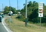
Truck US 441 (Leesburg) | Length: 4.1 mi. |
| Termini: Jct US 27 / 441 to Jct FL 44 in Leesburg | Years: 1980's / present | |
| Route: South on US 27 (14th Street) to FL 44, then east on FL 44 (Dixie Avenue) to US 441. | ||
| County: Lake | ||
| "Hidden" state number: FL 25, FL 44 | ||
| Co-signed with: |
||
| Drive: July 2001 - This route avoids downtown Leesburg, keeping traffic on four-lane highways. There is a sharp turn where US 27 and FL 44 intersect. Approaching from the south, there are remains of a thru lane on private property between the US 27 and Truck US 441. | ||

|
Truck US 441 (Eustis) | Length: 3.4 mi. |
| Termini: Jct CR 500A in Tavares to Jct FL 19 in Eustis | Years: 1980's / present | |
| Route: This is also mainline US 441, apparently. I suppose the route is signed to keep trucks out of Oakland Park. Termini are only estimated. | ||
| County: Lake | ||
| "Hidden" state number: FL 500 | ||
| Co-signed with: |
||
| Drive: Not yet | ||
![]() Click here to go back to
Florida in Kodachrome
Click here to go back to
Florida in Kodachrome
![]() Click here
to go to the history of US 441 in Florida
Click here
to go to the history of US 441 in Florida
Last update to this page on Tuesday, July 17, 2001