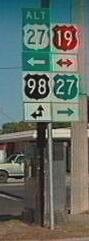
 US 19 / Alt US 19 US 19 / Alt US 19
 |
US 19 | Length in state: 258 mi. |
| Termini: FL: State line north of
Monticello to Jct US 41 near Memphis US: Erie, PA to Memphis |
Years: 1929 / present | |
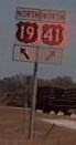
| Route: The US 19 corridor is sparsely populated outside of the Tampa Bay Area, dotted with ghost motels and faded tourist traps. South of Monticello at the small town of Capps, US 19 turns southeasterly, passing though the towns of Perry, Old Town, Chiefland, Lebanon Station, Crystal River, Homosassa Springs, Weeki Wachee and Hudson before hitting the Tampa Bay area cities of New Port Richey, Holiday, Dunedin, Clearwater, Largo, Pinellas Park, and St. Petersburg. It crosses the Sunshine Skyway with I-275, and ends short of Palmetto / Bradenton at a junction with US 41. | ||
| Counties: Jefferson, Madison, Taylor, Lafayette, Dixie, Gilchrist, Levy, Citrus, Hernando, Pasco, Pinellas, Hillsborough, Manatee | ||
| "Hidden" state numbers: FL 57 from Georgia state line to Capps, FL 20 from Capps to Perry, FL 55 from Perry to Memphis | ||
| Co-signed with: |
||
| Drive: North of Capps, this is the Florida / Georgia Parkway. Between Perry and Weeki Wachee, it is a four-lane divided highway that brings to mind the pre-interstate highways I recall from the 1970's. I spotted at least three civil defense type sirens in the Crystal River area, presumably because of the nuclear power plant. US 19 from Weeki Wachee to St. Petersburg is wider, mostly six lanes and increasingly restricted access. US 19 in Pinellas County is very heavily travelled and may one day be upgraded to Interstate quality. US 19's brief entry into Hillsborough County is in the middle of the Sunshine Skyway bridge. There was talk when the Sunshine skyway corridor was upgraded to handle I-275 that US 19 would be truncated at St. Ptertsburg, but Bradenton and Manatee county protested. | ||
 |
Alternate US 19 (West Florida) | Length: 32 mi. |
| Termini: Brooksville to Bayonet Point | Years: 1937 /1938 | |
| Route: Down what is now US 41 from Brooksville to Gowers Corner, the west to the coast. This Alternate US 19 existed before color signs were implemented. | ||
| Counties: Hernando, Pasco | ||
| "Hidden" state routes: Old FL 5 (FL 45) from Brooksville to Gowers Corner, Old FL 210 (FL 52) from Gowers Corner to Bayonet Point | ||
| Was co-signed with: |
||
| Drive: This was part of the the original route of US 19 in Florida from 1930 to 1937, and did not spend a long time as an Alternate Route. | ||
|
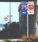
Alternate US 19 (St. Petersburg) | Length: 35 mi. |
| Termini: Holiday to St. Petersburg | Years: 1951 / Present | |
| Route: The original route of US 19 from 1930 to 1951. It hugs the Gulf coast, servicing Tarpon Springs, Dunedin, Clearwater, Seminole, before ending at US 19 in St. Petersburg. In the 1960's, Alt US 19 followed US 19's old route all the way to US 92. | ||
| Counties: Pasco, Pinellas | ||
| "Hidden" state number: FL 595 | ||
| Co-signed with: None | ||
| Drive: There are plans to re-align Alternate US 19 through Clearwater. This is good news for those wishing to use it for commuting, bad news for the businesses championing the project as a way to make the community walkable. The commuinty will be more walkable after the traffic (customers) are gone out to the new Alt US 19. | ||

![]() Click here to go back to Florida in Kodachrome
Click here to go back to Florida in Kodachrome
![]() Click here to go to the history of US 19 in Florida.
Click here to go to the history of US 19 in Florida.
Last update to this page on Monday, December 11, 2006.