 North - South US
routes in Florida's Panhandle North - South US
routes in Florida's Panhandle
North - South US
routes in Florida's Panhandle North - South US
routes in Florida's PanhandleUS 29 / US 129 / Alt US 129 / US 221 / Trk US 221 / US 231 / US 319 / Alt US 319 / Bus US 319 / US 331


|
US 29 | Length: 43 mi. |
| Termini: FL: State line at South
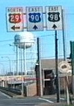
Flomaton to Jct US 90 / 98 in Pensacola US: Mount Hebron, MD to Pensacola |
Years: (As US 331: 1926-1936) 1935 / present | |
| Route: The only major cities on this route are Ensley and Pensacola. This was the original route of US 331 in Florida and the USA, numbered in 1926. US 29 and US 331 shared the route in 1936. The original US 331 was decommissioned in 1937. Other towns on the route are Century, Pine Barren, Gonzalez, then Ensley and Pensacola, where it ends at a junction with US 90 and US 98. The routes is multilane its route from the Alabama border to downtown Pensacola. | ||
| County: Escambia | ||
| "Hidden" state number: FL 95 | ||
| Co-signed with: None
currently, formerly |
||
| Drive: In Pensacola, US 29 runs parallel to I-110. It is rumored I-110 may be extended north along this route, or another I-number may be applied to this corridor. | ||


|
US 129 | Length: 88 mi. |
| Termini: FL: State line near Avoca
to Jct US 19 / 998/ 27A in Chiefland US: Knoxville, TN to Chiefland |
Years: 1941 / present | |
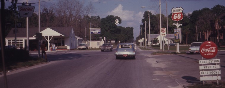
| Route: No cities greater than 10,000 population are on this two-lane road into the state. US 129 passes thru the towns of Jasper, Live Oak, Branford, Trenton, and ending in Chiefland with a junction with US 19, US 98 and Alt US 27. | ||
| Counties: Hamilton, Suwannee, Gilchrist, Levy | ||
| "Hidden" state numbers: FL 100 State line to Jasper, FL 51 Jasper to Live Oak, FL 249 Live Oak to Branford, FL 20 Branford to east of Branford, FL 49 east of Branford to Chiefland | ||
| Co-signed with: |
||
| Drive: The end of the route in Chiefland is unremarkable, a commercial district across from a school. | ||


|
Alternate US 129 (Decommissioned) | Length: 27 mi. |
| Termini: Jct US 129 in Branford to Jct US 19 / 98 / 27A in Old Town | Years: 1959 / 1970 | |
| Route: Besides Branford and Old Town, the only community along Alt US 129 is Fletcher. There is an old settlement by the name of Grady up by Branford. This was the original two-lane route of US 129 west of the Suwanee River. I have seen no evidence that Alt US 129 extended from Old Town to Chiefland, as an alternate route normally would. | ||
| Counties: Suwannee, Lafayette, Dixie | ||
| "Hidden" state numbers: FL 20 Branford to west of Branford, FL 349 west of Branford to Old Town | ||
| Was co-signed with: |
||
| Drive: This two-lane state highway (FL 349) stretches along the west bank of the Suwannee River. There is no indication in Old Town this route ever existed, but there is an old gas station at the intersection that probably even saw US 129 on this route. | ||
|
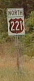
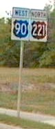
US 221 | Length: 40 mi. |
| Termini: FL: State line near
Ashville to Jct US 19 / 98 / 27A in Perry US: Lynchburg, VA to Perry |
Years: 1955 / present | |
| Route: Ashville, Greenville, Sirmans, Shady Grove, Lake Bird, Perry. It ends at a junction with US 19, US 98 and Alt US 27 south of Perry. The entire route is two lanes wide. | ||
| Counties: Jefferson, Madison, Taylor | ||
| "Hidden" state number: FL 55 | ||
| Co-signed with: |
||
| Drive: The end of US 221 is busy, US 221 is still a major commerce route from Georgia. | ||

|
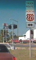
Truck US 221 | Length: 5.9 mi. |
| Termini: FL: Jct US 221 north of Perry to Jct US 19 / 98 / 221 / 27A in Perry | Years: 1980's / present | |
| Route: Much of the route is marked simply "Truck Route". North of Perry, Truck US 221 turns west on Wright Road (CR 359A) for 1.3 miles, then follows Byron Butler Pkwy into Perry. This route avoids the downtown area. | ||
| Counties: Taylor | ||
| "Hidden" state number: CR 359A, FL 20 | ||
| Co-signed with: |
||
| Drive: The northern mile or so of this route is a signed county highway. It was upgraded in the 1990's. I'm not certain what FDOT policy is on Truck routes. If I was setting it, they would all be state highways if they related to US or state routes. | ||
|
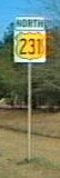
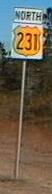
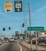
US 231 | Length: 52 mi. |
| Termini: FL: State line near Rambo
to Jct Bus US 98 in Panama City US: St. John, IN to Panama City |
Years: 1926 / present | |
| Route: The only major city on US 231 in Florida is Panama City. Even at that, it takes a multilane road the entire length of the route in the state to handle the tourist traffic. Other towns on the route are Campbellton, Cottondale, Betts, Youngstown, Nixon, Cairo and Hiland Park. It ends at a junction with Bus US 98. | ||
| Counties: Jackson, Bay | ||
| "Hidden" state number: FL 75 | ||
| Co-signed with: None | ||
| Drive: This route was been upgraded to four lanes in the late 1990's. It is a favorite travel route between Dothan, Alabama and the "Redneck Rivera" - Panama City, Florida. | ||

|
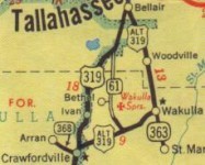
US 319 | Length: 106 mi. |
| Termini: FL: State line near
Iamonia to western foot of the John Gorrie Bridge,
Apalachicola US: Wadley, GA to Apalachicola |
Years: (As US 19: 1929-1932) 1932 / present | |
| Route: The only major city on US 319 in Florida is Tallahassee. The original routing of US 319 began there and ended at Eastpoint. Other towns on the route are Bradfordville, Crawfordville, Medart, Sopchoppy, Carrabelle, Eastpoint, Apalachicola. The southern ending is not marked, it is near the foot of the John Gorrie Memorial Bridge. US 98 continues into Apalachicola. Most of this road in Florida is two lanes wide, with the portion of the route on the eastern Capital Circle the only part of the route being widened to multilane status. | ||
| Counties: Leon, Wakulla, Franklin | ||
| "Hidden" state numbers: FL 61 State line to El Destinado, FL 261 from El Destinado to Bellair, FL 263 Bellair to Lakeside, FL 61 in Lakeside, FL 369 Lakeside to Crawfordville, FL 61 Crawfordville to Medart, FL 375 Medart to Sopchoppy, FL 377 Sopchoppy to west of St. Teresa Beach, FL 30 west of St. Teresa Beach to Apalachicola | ||
| Co-signed with: |
||
| Drive: From Apalachicola to Jct US 98 near St. Theresa Beach, this route is practically invisible, with US 98 being the primary route number. | ||


|
Alternate US 319 (Decommissioned) | Length: 21 mi. |
| Termini: Jct US 319 in Bellair to Jct US 319 in Crawfordville | Year: 1950 | |
| Route: The was the former route of US 319 south of Tallahassee to Crawfordville. | ||
| Counties: Leon, Wakulla | ||
| "Hidden" state numbers: FL 363 Tallahassee to Wakulla, CR 365, then CR 61 to Crawforville | ||
| Co-signed with: None | ||
| If Alt US 319 was signed, it was only for a brief period. It may have been wishful thinking from a cartographer with General Drafting on the Standard Oil (KY) map. | ||
|
Business US 319 | Length: 15.2 mi. |
| Termini: Jct US 319 near Maclay State Gardens to Jct US 319 in the Lakeside area of Tallahassee | Years: Early 1970's | |
| Route: After US 319 was moved to the newly built Capital Circle in Tallahassee, the old portion of US 319 though the heart of the city was briefly re-signed as Bus US 319. Business US 319 followed current FL 61. From Crawfordville Rd, on to Monroe Street, then down Woodville Highway to the intersection with Capitol Circle. The route that was Bus US 319 is mostly an undivided multilane local highway. (Existence of Bus US 319 @ 1971 confirmed by Ian Beverly w/ color scheme, based on a period photograph he recalls seeing.) | ||
| County: Leon | ||
| "Hidden" state numbers: FL 61 on Crawfordville Rd and Monroe St, FL 363 on Woodville Highway. | ||
| Was co-signed with: |
||
| Drive: I don't know why this routing was not retained by FDOT, it would have been a logical numbering to assist out of town traffic looking for State government offices, tourist attractions, and local colleges for sporting events. | ||
|
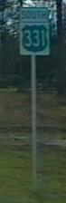
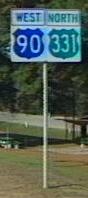
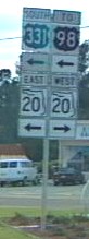
US 331 | Length: 50 mi. |
| Termini: FL: State line near Paxton
to Jct US 98 near Santa Rosa Beach US: Montgomery, AL to Santa Rosa Beach |
Years: 1954 / present | |
| Route: No major cities are on the route of US 331 in Florida. Towns on the route include Liberty, DeFuniak Springs, Owl's Head, and Freeport. It ends at a junction with US 98 east of Santa Rosa Beach. Tourist traffic on this road is much lighterthan on US 231, requiring only two lanes so far. | ||
| County: Walton | ||
| "Hidden" state numbers: FL 187 State line to south of Narrows, FL 10 south of Narrows to DeFuniak Springs, FL 83 DeFuniak Springs to east of Santa Rosa Beach | ||
| Co-signed with: |
||
| Drive: This is the second existance of the number US 331 in Florida, prior to 1938, the route now numbered US 29 was US 331. | ||
![]() Click here to go back to
Florida in Kodachrome
Click here to go back to
Florida in Kodachrome
![]() Click on any of the following: To the history of US 29 in
Florida. To the
history of US 129 in Florida. To the history of US 221 in Florida. To the history of US 231 in Florida. To the history of US 319 in Florida. To the history of US 331 in Florida.
Click on any of the following: To the history of US 29 in
Florida. To the
history of US 129 in Florida. To the history of US 221 in Florida. To the history of US 231 in Florida. To the history of US 319 in Florida. To the history of US 331 in Florida.
Last update to this page on Thursday, January 23, 2003