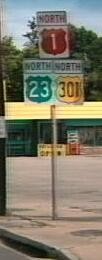
 US
1 / Alt US 1 / Bus US 1 / US 23 US
1 / Alt US 1 / Bus US 1 / US 23
US
1 / Alt US 1 / Bus US 1 / US 23 US
1 / Alt US 1 / Bus US 1 / US 23
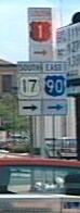
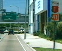
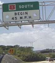
 Jacksonville
Acosta Bridge
Northeast Coast
Jacksonville
Acosta Bridge
Northeast Coast  St Augustine Homestead

|
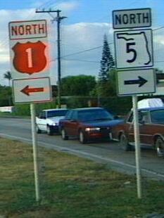
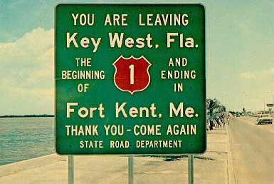
US 1 | Length in state: 533 mi. |
| Termini: FL: State line near
Boulogne to Key West at the Monroe County Court House US: Fort Kent, ME to Key West |
Years: 1926 / present | |
| Route: Jacksonville, Saint Augustine, Ormond Beach, Holly Hill, Daytona Beach, South Daytona, Port Orange, New Smyrna Beach, Edgewater, Titusville, Cocoa, Rockledge, Melbourne, Palm Bay, Sebastian, Vero Beach, Fort Pierce, Stuart, Hobe Sound, Jupiter, North Palm Beach, Riviera Beach, West Palm Beach, Lake Worth, Boynton Beach, Delray Beach, Boca Raton, Deerfield Beach, Pompano Beach, Fort Lauderdale, Dania, Hollywood, Hallandale, North Miami Beach, North Miami, Miami, Coral Gables, South Miami, Kendall, Perrine, Homestead, Key Largo, to Key West, where it ends at an intersection in front of Key West's City Hall. | ||
| Counties: Nassau, Duval, St. Johns, Flagler, Volusia, Brevard, Indian River, St. Lucie, Martin, Palm Beach, Broward, Dade, Monroe | ||
| "Hidden" state numbers: FL 15 State Line to Jacksonville, FL 5 Jacksonville to Key West | ||
| Co-signed with: |
||
| Drive: Jacksonville:
(Dan "Spui" Moraseski 3/99) US 1 / US 90 is a
freeway from the Main Street bridge to I-95. (7-5-99) The one way pair in West Palm Beach is mostly eliminated, US 1 is on FL 805 and FL 5 is signed on what used to be the northbound lanes, carrying two-way traffic. From Miami to Key West (8/98): Mostly a two-lane highway, with occasional passing lanes well signed in advance in a Burma-Shave manner. In the Keys, US 1 is mostly a two lane highway. The bridges are modern, with great views of the older modified rail bridges along the way. Mile markers show you the distance to the end of the road at the Monroe county courthouse, a rarity for a non-limited access highway in Florida. |
||
| US 1 has been around since the earliest planning stages, it is in the 1925 BPR plan. In 1927, it entered the state south of Folkston, GA. It was routed through Jacksonville, St. Augustine, Daytona, Titusville, Melbourne, Fort Pierce, West Palm Beach, and ended in Miami at US 94. The original route largely followed the east or "main" leg of the Dixie Highway. Heading south, US 1 followed a route close to its current alignment till US 23 leaves it. The route of US 23 into Jacksonville, "Old Kings Rd", is the original US 1. The name seems to change to State St in downtown Jacksonville. Main St, then as now, carries US 1 south to the Saint John's River. Across the river, a jog over St. Johns Ave lead back to the straighter route south, Hendricks Blvd. (Now FL 13). The route moved back east from Goodbys over Old St Augustine Road to join with the current alignment at Bayard. By 1935, US 1 was a straight shot between South Jacksonville and Bayard. The route through St. Augustine has been Bus US 1 since the 1960's. At Korona, US 1 took an eastward bend from current routes along Old Dixie Highway, following that south to Ormond Beach. US 1 followed a more coastal route earlier on, staying on Scenic Dr/Beach St/Riverside Dr/Beach St till Bellevue Ave, where it jogged west to current Ridgewood Ave. US 92 used to start here. In New Smyrna Beach, US 1 entered the city on Orange St, then turned left on Canal St, then back right along Magnolia. CR 515, Old Dixie Highway, from Willimas Point to Bonaventure was probably not US 1. Likewise, Old Dixie Highway from Valkaria to Shell Pit Pt is not likely to have been signed US 1. At Shell Pit Pt is an oxbow signed Old US 1. In Cocoa, US 1 did run along Ridgeway Ave and Florida Ave briefly. Current CR 605 through Oslo may have briefly been US 1 (An Old Dixie Highway), as may have CR 707 through Jensen Beach (Another Old Dixie Highway). FL A1A from Stuart to Jupiter Island may have been US 1 in 1926 or 1927. By 1928, US 1 / Federal Way was built. US 1 in Fort Lauderdale followed the route marked 'Dixie Highway' which also was Broadway south to a possible one-way pair with Poinsettia between 59th St and 23rd St. Poinsettia carries the highway south to 12th St, then there is a possible one-way pair with Olive Ave south to Belvedere Rd, where Poinsettia carries the Dixie Highway to the city limits. In Delray beach, Fifth Ave carried US 1. Another place the Dixie Highway diverged was along what is now FL 811 from Boca Raton to Ft. Lauderdale, with the new US 1 taking the current and more coastal route. US 1 entered on what was NE 10th St, and went south on the then named SE 6th Ave. In Hollywood, US 1 followed the east Dixie Highway, same as it does now. In Hallandale, the alignment makes a westward jog to what is now FL 5A. US 1 passed through 'Fulford' (North Miami). The Miami original terminus is much the same as it was, but the streets had different names. NE 6th Ave as it enters the city, NE 3rd Ave south to SE 1st St, and the Courthouse, where US 94 also ended. By the late 1930's, US 1 was routed over FL 4A (now FL 905) (Card Sound Road) south of Florida City to the Florida coast while the newer alignment was under construction. During the late 1920's, Florida's State Road department set out to run a highway to Key West, paralleling the famed Florida East Coast "Overseas Railway". Ferries were used to bridge the gaps in this new "Overseas Highway". No Name Key was the southern ferry port as the road moved slowly southward. After the Great Hurricane of 1935 closed down the Key West line, the state road department bought the old rail bed. During the Second World War, some of the existing railroad bridges to Key West were converted to automobile traffic to complete the highway. Most of the original railroad bridges are still in existence alongside US 1. West of Bahia Honda Key is a steel truss bridge that was too narrow for conversion to a two-lane road. The Bahia Honda channel was also an unfinished link in the Overseas highway, so the State Road Department built a two-lane road over the top of the trusses. The old bridge has a sign warning small craft that debris may fall from the crumbling concrete highway. It is in poor shape. Many of the existing rail bridges out to Key West were widened, like the famous Seven-Mile Bridge. Older alignments of this road are still signed "Dixie Highway" or "Old Dixie Highway". Pre-1946 State Road numbers: FL 4 State Line to Miami, FL 4A south of Miami. | ||
| Auto Trails - AutoTrails: Kings Highway, Atlantic Highway, Dixie Highway (east), Lone Star Trail, Ocean Highway, Overseas Highway | ||
|
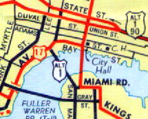
Alternate US 1 (Jacksonville) | Length: 5 mi. |
| Termini: Jacksonville | Years: 1954 / present | |
| Current Route: From the intersection of US 1 and the 20th Street Exp, down the Haines St Exp., then across the Hart Bridge to the Commodore Point Exp, then west on Emerson St to US 1. In the past, this route started at US 1 and Union St, running over the Mathews Bridge, east on what is now Alt US 90, then south on Southside Blvd (FL 115) to rejoin US 1. In 1965, the northern terminus was moved to its current location on the Expressway. In 1984, Alt US 1's southern terminus was shifted to its current location. | ||
| County: Duval | ||
| "Hidden" state numbers: FL 115 on 20th St Exp, FL115A on Haines St Exp, FL 228 on Hart Bridge / Commodore Point Exp, FL 126 on Emerson | ||
| Co-signed with: |
||
| Drive: -- | ||
|
Alternate US 1 (Acosta Bridge) | Length: 1.3 mi. |
| Termini: Jacksonville | Years: 1958 / 1960 | |
| Route: This former route went from US 1 / US 23 down Broad Street, then was co-signed with US 17 for a short time on Riverside Dr, then across the St. John's River on the Old Acosta Bridge (with a rail line) | ||
| County: Duval | ||
| "Hidden" state number: FL 13 | ||
| Co-signed with: |
||
| Drive: The Acosta Bridge was replaced in 1998, the new one is called the New Acosta Bridge. I never drove over the old bridge. | ||
|
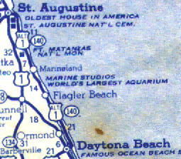
Alternate US 1 (Northeast Coast) | Length: 53 mi. |
| Termini: St. Augustine to Daytona Beach | Years: 1941 / 1946 | |
| Route: (From the 1946 Rand McNally Atlas & Texaco SE US 1946; Texaco Virginia 1941) This coastal route followed then FL 140 (old scheme.) Now this route is FL A1A. FL changed its state road numbering in 1946, this stretch went from being FL 140 to FL 1. Having FL 1 and Alt US 1 on the same route may have been confusing to some motorists. Florida had applied for the new route, but WW2 put a hold on most route number changes. AASHO was not thrilled by the idea of the new coastal routing, and Florida had just renumbered it's state routes. By 1947, This Alt 1 was gone, and FL 1 became A1A. | ||
| Counties: St. John's, Flagler, Volusia | ||
| "Hidden" state numbers: Old FL 140, then FL 1, now FL A1A | ||
| Co-signed with: Old FL 140 | ||
| Drive: This is all now FL A1A, the request for the ALT US 1 designation was dropped when FL 1 was assigned to this coastal route. Much of this is now a designated Scenic Highway. Curiously enough, part of this route was once used as a racing facility at the south end, the original Daytona Beach raceway. | ||
|
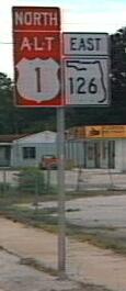
Business US 1 | Length: 2.7 mi. |
| Termini: Saint Augustine (Fort Mose to Moultrie Junction via western landing of Bridge of Lions) | Years: 1963 / present | |
| Route: From US 1 north of SR 16 following San Marcos Blvd south to Saint Augustine, then west on Kings Road to the intersection of US 1 and CR 214. This was a former route of US 1, and may have been originally signed Alt US 1 (1960 KYSO map). | ||
| County: St. John's | ||
| "Hidden" state number: FL 5A | ||
| Co-signed with: |
||
| Drive: Former route of US 1, Gene Janczynskyi reported the A1A co-signing. Passes by one of the oldest structures in the US, the Castillo de San Marcos. | ||
|
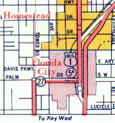
Business US 1 | Length: 4.1 mi. |
| Termini: Homestead | Years: 1958 - 1974 | |
| Route: From north of Homestead, following Old Dixie Highway though downtown Homestead, rejoining US 1 at Old Dixie Highway / Card Sound Rd. (Thanks to Dan Moraseski for first pointing this out) This is the old route of US 1 though downtown. | ||
| County: Dade (now Miami-Dade) | ||
| "Hidden" state numbers: FL 5A, FL 997 | ||
| Co-signed with: |
||
| Drive: Not much to this two-lane segment, a few older motels but not many. I was hoping for a look into old Florida. | ||
|
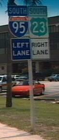
US 23 | Length in state: 37.7 mi. |
| Termini: FL: State line near
Boulogne to Jct US 1 / 17 in Jacksonville US: Mackinaw City, MI to Jacksonville |
Years: 1951 / present | |
| Route: Follows US 1 to Old Kings Road in Jacksonville, and follows Old Kings Road to terminate at US 1 / US 17 after 3.8 miles marked independently on the old route of US 1 / US 23 into Jacksonville. In the 1960's, there were plans to extend this highway further south to Sarasota - via Ocala, Leesburg, Winter Haven and Bartow. | ||
| Counties: Nassau, Duval | ||
| "Hidden" state numbers: FL 15 State Line to Jacksonville, FL 139 in Jacksonville. | ||
| Co-signed with: |
||
| Drive: The end of this route in Jacksonville is the former route of US 1. This route is essentially a "Business" route for US 1, connecting back with US 1 at its terminus. Unless US 23 is extended in Florida, it could be truncated north of Alma, GA and few would notice it. | ||
![]() Click to
return to Florida in Kodachrome
Click to
return to Florida in Kodachrome
![]() Click here to go to the
history of US 1 in Florida. Click
here to go to the history of US 23 in Florida.
Click here to go to the
history of US 1 in Florida. Click
here to go to the history of US 23 in Florida.
If you are traveling around the us or the world, make sure you have a world cell phone for all of your needs. Mapping a route is very important, but being within reach of friends, family, and help are also imperative for having an enjoyable and safe trip!
This page last modified Monday, October 06, 2008.