The Mount Shasta Region
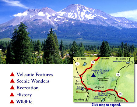
 This portion of the Volcanic Legacy Scenic Byway has the distinction of having a view of majestic Mount Shasta. Standing at 14,162 feet, this volcano is the tallest volcano in California, and the second highest in the Cascade Range. Mt. Shasta can often be seen from more than 100 miles away.
With lots to offer in terms of outdoor recreation, the town of Mt. Shasta itself has an inviting downtown shopping area with unique shop, galleries, and fine dining and lodging.
The Sisson Museum, the State Fish Hatchery, and the Headwaters of the Sacramento River are also regular stops for those who visit the area. The drive up Everitt Memorial Highway, taking you up 15 miles to about 7,800 feet in, elevation is another favorite activity.
Neighboring towns also offer some interesting points of interest. To the South, in the historic railroad town of Dunsmuir, you can take a walk in The Dunsmuir Botanical Gardens, cast a line in the Sacramento River, enjoy Mossbrae Falls and Hedge Creek Falls, and visit Castle Crags State Park.
To the North of mighty Mount Shasta, the town of Weed makes home to The Living Memorial Sculpture Gardens, Mt. Shasta Lavender Farms, Stewart Mineral Springs and Deer Mountain/Chuck Best Snownobile Park.
Also, marking the beginning of the highway 89 scenic corridor, McCloud has a charming, old fashioned charm famous and is famous for its fly fishing. McCloud Waterfalls are a definite stopover point for those whose wish to view three distinct water falls or hike on the nearby trail.
Mt. Shasta Chamber of Commerce
1-530-926-4865 or 1-800-926-4865
City of Mt. Shasta
530--926-7540
The Weed Chamber of Commerce
1-530-938-4624
The McCloud Chamber of Commerce
1-530-964-3113
The Dunsmuir Chamber of Commerce
1-530-235-2177
The Upper Sacramento River Exchange
1-530-235-2012
Castle Crags State Park
1-530-235-2684
Siskiyou County Visitor's Bureau Website
1-530-926-3850
Mt. Shasta Ranger Station
1-530-925-4511
Weather in Mt. Shasta
Click for Driving Instructions.
Click for the Butte Valley Region to the north
Click for the Waterfalls Region of McCloud and Burney to the south and east
Our web site is expanding weekly as we add new features and information. Please return to VolcanicLegacyByway.org for expanded pages on the services, attractions, activities and events to enjoy as you travel the Volcanic Legacy Scenic Byway.
- Crater Lake
- Upper Klamath Lake & Klamath Falls
- The Klamath Basin, Tulelake & Lava Beds
- Butte Valley
- Mount Shasta
- The Waterfalls, McCloud and Burney
- Hat Creek Rim
- Lassen Peak Region
- Lake Almanor
-
Interests
- Trip Planner
- Volcanic Spectacles
- Waterfalls
- Wildlife
- History
- Recreation
- Travel with Kids
- Lodging & Services
- RV & Camping
- Fishing & Hunting
- Scenic Wonders
- 2011 Calendar

 VolcanicLegacyByway.org is the Official Website for The Volcanic Legacy Scenic Byway All-American Road in California and Oregon.