The Upper Klamath Lake and Klamath Falls Region
Route Description
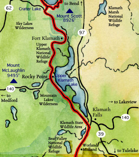 The Volcanic Legacy Scenic Byway follows Oregon Route 62 through peaceful pastures to Fort Klamath. Now a cattle-raising district, this area was the scene of frequent clashes between white settlers and the Modoc indians during the 1870's. The historic site of the military installation now has a reconstruction of one of the original buildings and several historical displays. The byway tour continues on Weed Road to Sevenmile Road west, then south on West Side Road along the edge of the Upper Klamath National Wildlife Refuge and Upper Klamath Lake.
Nearly 30 miles long and up to eight miles wide, and covering 133 square miles, the lake is largest body of freshwater west of the Rockies, filling a basin created when the earth's crust dropped along fault lines on both sides. Situated in the heart of the Pacific Flyway, the Upper Klamath Refuge was established in 1928 and is comprised of 15,000 acres of mostly freshwater marsh and open water. These habitats attract more than 250 species of birds, including sandhill cranes, pelicans and bald eagles. West Side Road connects with Oregon Route 140 at Rocky Point. Howard Bay is a common place to see nesting pelicans, blue herons and snow geese. The southern half of the lake is home to bald eagles all year round.
The Byway continues south as Oregon Route 140 meets U. S. Route 97 two miles south of downtown Klamath Falls. Take a trip into town to visit the historic Baldwin Hotel Museum and the Favell Museum's impressive collection of Indian artifacts. Then head south again on U. S. Route 97, passing through cropland along the Klamath River. You'll travel between the Bear Valley National Wildlife Refuge and Lower Klamath National Refuge, our nation's first waterfowl refuge (established by President Theodore Roosevelt in 1908). This segment of the Byway ends on the California border at the Francis S. Landrum Historic Wayside, which commemorates the Applegate Emigrant Trail.
Discover Klamath Visitors' Bureau
1-800-445-6728
Klamath County Chamber of Commerce
(541) 884-5193
Click for the Crater Lake Region to the north
Click for the Klamath Basin, Tulelake and Lava Beds National Monument Region to the south
Our web site is expanding weekly as we add new features and information. Please return to VolcanicLegacyByway.org for expanded pages on the services, attractions, activities and events to enjoy as you travel the Crater Lake segment of the Volcanic Legacy Scenic Byway.