Volcanic Spectacles
The Volcanic Legacy Scenic Byway traverses the southern section of the great Cascade range, a chain of active volcanoes that stretch from the Canadian border to northern California.
Of the 13 potentially active volcanoes in the Cascade Range of the Pacific Northwest, 11 have erupted in the past 4,000 years and 7 in just the past 200 years. Cascade volcanoes tend to erupt explosively, and on average two eruptions occur per century--the most recent were at Mount St. Helens, Washington (1980-86), and Lassen Peak, California (1914-17).
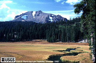
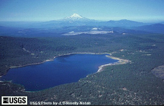 While not the tallest, the Medicine Lake volcano is actually the largest volcano along the Byway. In fact, with a volume of more than 130 cubic miles, it is the largest volcano in the entire Cascade range. Medicine Lake Volcano, a broad shield capped by a 4- by 7-mile caldera, has erupted at least 8 times in the past 4,000 years, most recently about 900 years ago. This photo from the USGS shows the Medicine Lake caldera with Mount Shasta in the distance.
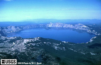 The major volcanoes you will explore along the Byway are Crater Lake, Medicine Lake, Mount Shasta and Mount Lassen. Crater Lake, or Mount Mazama, is the least active of these peaks...it has not been active for over 4000 years. The 6 mile wide caldera, which Crater Lake now fills, formed when a massive ash eruption 6,950 years ago emptied the magma chamber underneath Mount Mazama, causing it to collapse. The four thousand foot deep hole has filled with rain and snowmelt to a depth of about 1,900 feet. Seepage and evaporation now balance the incoming precipitation, and the level of the lake remains nearly constant.
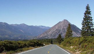 Although a small peak, Black Butte is a unique volcano--and not a small part of its nearby neighbor Mount Shasta--known as a plug dome. A plug dome is a steep-sided, rounded mound formed when viscous lava wells up into a crater and is too stiff to flow away. It piles up as a dome-shaped mass, often completely filling the vent from which it emerged. In the middle of the valley to the west of Mount Shasta, and often mistaken for it by visitors when the bigger mountain is obscured by clouds, the tiny Black Butte volcanois made of four overlapping dacite lava domes that erupted about 9,500 yearsago. A Forest Service fire lookout cabin once covered the top of Black Butte.Today, this peak provides one of the finest hikes of the entire Byway region.
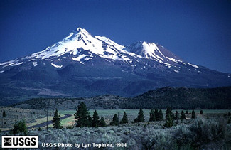 At 14,162 feet above seal level, Mount Shasta, a composite or strato volcano is the tallest volcano on the Byway. A composite volcano is typically a steep-sided, symmetrical cone of large dimension built of alternating layers of lava flows, volcanic ash, cinders, blocks, and bombs and may rise as much as 8,000 feet above their bases. Mount Shasta actually consists of the remains of at least four different cones, two of which were destroyed by erosion or explosion. Mount Shasta has been the most active volcano in California during the past 4,000 years, and is second tallest in the entire Cascade Range, next to Mount Rainier. During that time, Mount Shasta erupted on average about once every 300 years, producing many pyroclastic flows. It probably last erupted in 1786. Shastina, the northernmost peak of Mount Shasta, is a large subsidiary cone on the west flank of this volcano.
 Lassen Volcanic Field, including Lassen Peak, is the southernmost volcanic center in the Cascades. Lassen Peak is a plug dome and its most recent volcanic eruptions in California occurred between 1914 to 1917. An explosive eruption on May 22, 1915, produced a large pyroclastic flow, lahars, and ash that fell as far away as Elko, Nevada, 300 miles to the east.
You will pass many more small volcanoes as you drive the Byway. The Cascades are actually made up mostly of hundreds (even thousands) of small shield volcanoes that lie between the large stratovolcanoes like Mount Shasta and Crater Lake (the former Mount Mazama). Deer Mountain, for example, on the road between Weed and Dorris in northern California, is a fairly small shield volcano separate from both Mount Shasta and the Medicine Lake volcano.
Please follow the links below to discover information on the volcanic features found along the Volcanic Legacy Scenic Byway.
- Visit the Cascades Volcano Observatory on the Web. This extensive web site from the U. S. Department of the Interior - U. S. Geological Survey, has a wealth of information about the volcanoes of the Byway and the entire Cascade range.
- Does Pumice float? ... What is the tallest volcano in the Cascade Range? ... Test how well you know your volcanoes and volcanic terminology ... Here are the 59 'Most Frequently Asked Questions' (with answers) covering general information, Mount St. Helens and the Cascade Range Volcanoes, Alaskan and Hawaiian Volcanoes, and volcanic features and processes. ... Enjoy!
- How did the volcanoes get their names? Visit Volcano Names and History for the answers.
- Read an overview of the geology of the Volcanic Legacy: A Brief History of Fire and Ice
- Learn lots about Mount Mazama at the Geology of Crater Lake pages. Lava Beds National Monument is located on the north flank of the Medicine Lake volcano. Find information on this area of the Byway at the Lava Beds National Monument Geology pages.
- Read an Introduction to the Geology of the Mount Shasta Region by Dr. William Hirt at College of the Siskiyous in nearby Weed, Califonria.
- Lots more about the geology of northern California from the geology program at the College of the Siskiyous, including Local Geology Links and 'Is this a dangerous volcano?' describing Mount Shasta's eruptive history and its likely future activity.
- Study the most recent eruptions of Lassen Peak and the hydrothermal activity in Lassen National Park.
- Learning more about volcanoes is easy with the illustrated glossary at the USGS web site. Just click on a word (like pyroclastic flow, lava dome, shield volcano or cinder cone) to see its picture and read the definition.
- Discover the Subway Caves just south of Burney-- on Hwy 89, just a 1/4 of a mile North on Hwy 44.
- Crater Lake
- Upper Klamath Lake & Klamath Falls
- The Klamath Basin, Tulelake & Lava Beds
- Butte Valley
- Mount Shasta
- The Waterfalls, McCloud and Burney
- Hat Creek Rim
- Lassen Peak Region
- Lake Almanor
-
Interests
- Trip Planner
- Volcanic Spectacles
- Wildlife
- History
- Recreation
- Travel with Kids
- Lodging & Services
- RV & Camping
- Fishing & Hunting
- Scenic Wonders
- 2011 Calendar

 VolcanicLegacyByway.org is the Official Website for The Volcanic Legacy Scenic Byway All-American Road in California and Oregon.