The Butte Valley Region
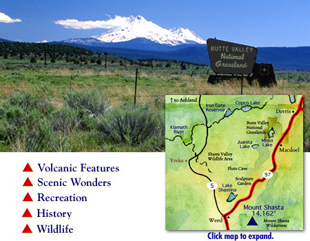 The Butte Valley region presents sweeping vistas of ranch, farm and grass lands spreading across the valley floor. Butte Valley includes the communities of Macdoel, Mt. Hebron, Tennant, Bray and the City of Dorris. Known as a high desert plateau, it is an area dropped down between faults and encircled by volcanoes to form a closed drainage basin. The down-faulted valley has subsequently been filled to its present elevation of 4,250 feet by alluvial debris washed into the valley from the surrounding volcanic mountains, by lava flows and by lake deposits. Wildlife viewing and the many Lakes--Orr Lake, Juanita Lake, and Meiss Lake--are some of the highlights of this area. Also, the Butte Valley National Grasslands stretches between the towns of Dorris and Macdoel.
If you're passing through Macdoel during the winter, bundle up and follow the wildlife viewing signs and keep an eye out for bald eagles. While in Dorris pull the car over so you can get out and tip your head way back to peer up at the tallest flagpole west of the Mississippi.
If you approach the region from the south, you will pass the Living Memorial Sculpture Garden and Labyrinth, just outside of Weed, which stands as a tribute to America's veterans.
Follow the links below for detailed information on the Butte Valley Segment of the Volcanic Legacy Scenic Byway.
Butte Valley Chamber of Commerce
530-397-2111
The Weed Chamber of Commerce
530-938-4624 or 1-877-938-4624
The Shasta Trinity National Forest
530-226-2500
The National Grasslands web site
Click for Driving Instructions.Click for the Klamath Basin, Tulelake and Lava Beds National Monument Region to the north and east
Click for the Mount Shasta Region to the south
Our web site is expanding weekly as we add new features and information. Please return to VolcanicLegacyByway.org for expanded pages on the services, attractions, activities and events to enjoy as you travel the Butte Valley segment of the Volcanic Legacy Scenic Byway.