You will find it easy to get distracted by the variety of activities and attractions along the Byway. We have outlined activities for a one day exploration of each of the regions along the Byway. So depending on how many days you plan to spend on the Byway, choose from the adventures listed below.On your drive along this unique corridor we invite to allow yourself to be distracted, because out here the adventure begins with the journey. To find accomodationas--motels, hotels, vacations rentals, or camping sites-- find the pages of the area you want to visit. Here you will find links to visitors' bureaus and chambers of commerce with lists of accomodations. If you prefer, call us at 1-866-722-9929 and we can help you with this.
Lake Almanor area
Southern most entrance
Come in to the Lake Almanor area from Sacramento by following Highway 99 to Chico and then heading east on Highway 32. You can take a more southerly route by cutting east from Oroville then north on Highway 89 through the town of Greenville to the southern tip of Lake Almanor.
Lake Almanor is a water lover's paradise. The lake is home to great year-round fishing and just about any kind of water craft activities. The west side of the lake, where you'll find the town of Almanor and other small villages, has a wonderful summer family camp atmosphere. Camp resorts and inns along the lake shore put you right on the water and also offer hiking, biking and dog walking trails for a little time on land. The area also has new SUV routes for drivers looking to throw up some dust.
The east side of the lake has great views of Mount Lassen and has a more secluded feel. On the northern end of the lake Chester is a great place to stay for the night and get dinner and supplies. While in Chester be sure to look for "Dinky" the Locomotive on Main Street.
The peninsula area on the north end is exploding with development and is home to a growing number of beautiful golf courses. For a look back into the logging history of the area, take a short drive east on Highway 36 to Westwood and on the way look for the Biz Johnson Trail along the highway that was built on 25 miles of old Southern Pacific Railroad bed.
For more on the Lake Almanor region, along with links to other websites, see our Lake Almanor section.
Lassen Volcanic National Park
Southern entrance
Come in to the Mount Lassen area from Interstate 5 at Red Bluff on Highway 36 or Redding at Highway 44. From the east you can get to the Park by coming through Susanville and heading west on Highway 36 then north on Highway 89.
Lassen Volcanic National Park is home to Lassen Peak, one of the largest plug dome volcanoes in the world. Geothermal features like the boiling mudpots and steaming fumaroles of Bumpass Hell, Boiling Springs lakes and Terminal Geyser attest to the heat that lies beneath the surface. The area's last eruptive episodes began in 1914 and massive mudflows caused by eruptions created "The Devastated Area."
The park is not all steaming lakes and sulphur. It is also home to 150 miles of trails and opportunities for swimming, boating, fishing, cycling and backcountry hiking and camping. At the Loomis Museum visitors can learn about the cultural and geologic history of the park as well as get information about programs and events. The Park also has a naturalist-led program that takes visitors on a journey through the park while they learn about various features.
After a day of outdoor adventure, travelers can rest in the communities of Burney, Chester or Susanville, which offer nearby lodging and dining.
Activities and access are limited at the Park during the winter and spring months; however, cross country skiing, snowshoeing and snowmobiling are permitted.
For more on the Mount Lassen region, along with links to other websites, see our Mount Lassen section.
The Waterfalls Region
Southern and Western entrance
The best enterance into the Waterfalls Region is to continue northward on the Byway from either of the southern enterances listed above. A western enterance from Interstate 5 is available on Highway, between the town of Mount Shasta and Dunsmuir.
The Waterfalls Region is home to Burney Falls and the McCloud River Falls, displaying a total of four waterfalls to travelers. As you drive north on the Byway the first stop of the day will be at McArthur-Burney Falls Memorial State Park. The Park offers five miles of hiking trails, which includes a trail to the base of 129 foot Burney Falls where visitors can bask in the mist from the falls. The Park also includes a section of the Pacific Crest Trail as well as campsites and showers, making it an ideal overnight stop. The nearby town of Burney is a good place to get a meal and stock up on snacks and drinks.
Shortly after leaving the Park, the Byway crosses over Lake Britton, where outdoor lovers can enjoy fishing, boating and camping.
The next stop for water lovers is theMcCloud Falls complex, which has trails along the river, picnic areas, campgrounds and handicap accessible areas. At Fowler's Camp travelers can walk down onto a rock ledge to fish or perhaps swim in the cold water. Trails through the forest lead to the Middle and Upper Falls. The McCloud River is also a year round fly fishing river that empties into the remote Lake McCloud.
After a day in the Waterfalls Region lodging, dining and services are available in the towns of McCloud and Mount Shasta.
For more on the Waterfalls region, along with links to other websites, see our Waterfalls section.
The Mount Shasta Region
Southern and Northern entrance
Travelers heading south from Oregon can enter the Byway from Interstate 5 at Weed or Mount Shasta. Those heading north from Redding can do the same. This is the only region of the Byway that contains a portion of Interstate 5.
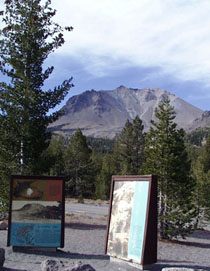
The Mount Shasta Region offers travelers the opportunity get up close to a strato volcano. The 14,162 foot Mount Shasta has an eruptive past, with four vents on the mountain itself and four more on Black Butte, the cinder cone to the north. In Mt. Shasta city take Everitt Memorial Highway to approximately 8,000 feet on the slopes of the mountain. At Bunny Flat visitors can stop just for the view or to hike the trail to the cabin at Horse Camp where they can drink from the spring during early summer.
Adventurers who are interested in hiking on Mount Shasta, attempting a summit climb or learning about the geologic past of the mountain should visit the Mount Shasta Ranger District office.
Farther north around the mountain travelers will come to the historic logging town of Weed where many of the old lumber town homes and buildings still stand. Outside of Weed, on Highway 97 heading north, travelers can take time out at the Living Memorial Sculpture Garden to view the memorials to America's veterans and to walk the Labyrinth. This area also offers a view of the mountain quite different from the view in Mt. Shasta city.
Both Weed and Mt. Shasta offer lodging, dining and services, as well as entry onto Interstate 5.
For more on the Mount Shasta region, along with links to other websites, see our Mount Shasta section.
The Klamath Basin, Tulelake, and Lava Beds Region
Southern and Western entrance
Travelers heading south in Oregon can enter the Byway from Interstate 5 by heading east at Ashland on Highway 66. To get to this region turn south on Highway 97. Those heading north from Redding should take the Weed exit on Interstate 5 and head east on Highway 97.
This region offers a diverse selection of activities from wildlife viewing to spelunking. The towns of Macdoel and Dorris are part of the thriving agricultural community. In Dorris travelers can view the tallest flagpole west of the Mississippi River. At Highway 161 turn east and enter the Klamath Basin where wildlife viewing is available at the Lower Klamath National Wildlife Refuge and the Tule Lake National Wildlife Refuge. Both refuges have self guided driving tour routes and are home to huge numbers of wintering bald eagles. The Refuge Visitors Center on Hill Road has a vast information base regarding the species that live and migrate to the refuges as well as an interpretive area.
If you continue driving south on Hill Road you will enter the Lava Beds National Monument, where a band of Modoc Indians used the harsh volcanic landscape to hold off the U.S. Army in the Modoc Indian War of 1872-73. The Visitors Center has information about the war and Captain Jack's Stronghold, which the Modocs used as a fortress. The Lava Beds is home to hundreds of caves created by underground lava flows during the creation of the Medicine Lake shield volcano.
While visiting this area, lodging, dining and services are available in Dorris and Tulelake.
For more on the Tulelake region, along with links to other websites, see our Tulelake section.
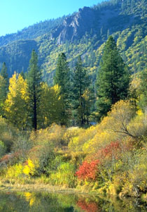
The Byway region has wonderful fall colors.
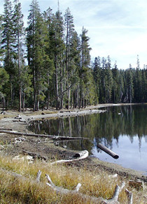
The region's mountain lakes welcome you.
The Devastation Area in Lassen Volcanic National Park.
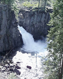
A view of Upper McCloud Falls.
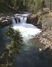
A view of Lower McCloud Falls.
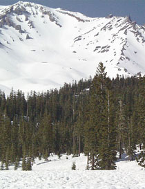
A look at Mount Shasta from near Bunny Flat and Horse Camp.
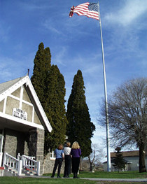
Dorris proudly hosts the tallest flagpole west of the Mississippi River.