The Overland Trail

The Overland Trail Mail route was established and owned by Ben Holladay, the "Stagecoach King." Sometimes confused with the "Oregon" or "California" Trail, which actually followed the North Platte Valley from Nebraska through Wyoming, the Overland Trail refers specifically to that portion of the mail and passenger route, established in 1862, that avoided the Indian uprisings that were occurring on the Oregon Trail farther north through central Wyoming along the Sweetwater-South Pass route. In July, 1862, the US Post Office Department ordered Ben Holladay, and the Overland Stage Company, to officially relocate from the central Wyoming route, to a route which had been known, in part, as the Cherokee Trail. Not just a cutoff or a detour, it became for a while the only emigrant route on which the US Government would allow travel, and consequently was the principal corridor to the west from 1862 to 1868.
The Overland Trail ran westward from Atchison, Kansas, following the Oregon Trail more or less, with some diversions created by Ben Holladay, such as the Oketo Cutoff in Kansas. At Julesburg, Colorado, it essentially left the Oregon Trail, paralleling, on the south side, the South Platte River to Latham (present day Greeley). Latham was a junction: one could travel south to the Cherry Creek settlement of Denver, or cross the river and loop north along the foothills, following the established Cherokee Trail, crossing the Cache la Poudre River at LaPorte.
In 1864 the Fort Morgan Cutoff was established to save some time and milage between the South Platte and Denver, even though this route had a scarcity of water and good grazing for the stock. The stations between Bijou and Latham were pretty much bypassed. This new route passed the old fur trading forts of St. Vrain and Vasquez, established 30 or so years earlier, and also added stations from Denver and LaPorte on the Boulder, St. Vrain, and Big Thompson Rivers, including a few in between.
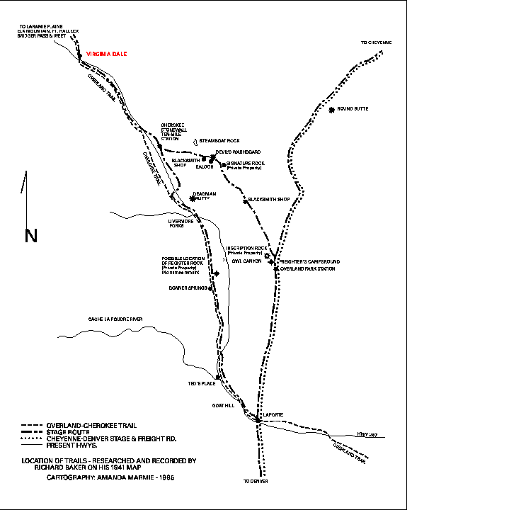
Continuing north, the Overland Trail split into at least two separate routes between LaPorte and Virginia Dale. One route veered off to the east toward Ft. Laramie, located about 50 miles north of present day Cheyenne; the other route, which was essentially the old Cherokee Trail, took a bit more westerly route to the home station at Virginia Dale. Beyond Virginia Dale, the first station established in Wyoming was Willow Springs, about one mile to the west of present day Tie Siding. From there the trail crossed the Laramie Plains and skirted the north side of Elk Mountain near Fort Halleck, and the Medicine Bow Mountains. Crossing the North Platte near the mouth of Sage Creek, it continued west, through Bridger's Pass, roughly paralleling present day Highway I-80 and the Union Pacific Railroad through Wyoming, finally rejoining the Oregon Trail again in western Wyoming at Ft. Bridger.
It is estimated that as many as 20,000 emigrants traveled the Overland Trail each year, from 1862 to 1868. Many trail diaries mention the number of people and stock on the trail, and Dr. J. H. Finfrock, the surgeon at Fort Halleck, kept tallies of the wagons, men, women, children and livestock passing through.
Moving the route did not cause the Indian problems to stop. The threat of Indian attact became increasingly more prevalent as more and more emigrants made their way to the west. Eventually more military posts were erected along the stage and wagon routes, and the Indian problems gradually decreased.
The shrewd Ben Holladay maintained a virtual monopoly of the Overland Stage line until 1866 when he decided to sell out. Well aware that the inevitable completion of the new Transcontinental Railroad would eliminate the need for stagecoach transportation, Holladay was fortunate to be able to sell the route, the equipment and the contracts to Wells, Fargo. The stage coach had made Wells, Fargo dominant in the west, and they were determined to maintain that dominance. The overland mail continued on for another 2 1/2 years along the Overland Trail, until the Union Pacific and the Central Pacific railroads met at Promontory Point, Utah in 1869. The meeting of the rails marked the end of an era, and the Overland Stage Line came to an abrupt end.
A Clickable Map of Stage Stations on the Overland Trail from Julesburg to Ft. Bridger.
Closer view of map and more detail about the stage stations from LaPorte to Virginia Dale.

Send comments, suggestions or inquiries:
Overland Trail
[Overland Trail Home Page | Looking At The Trail | Links | Virginia Dale]
Created and maintained by Elizabeth Larson
1996-2000