From LaPorte to Virginia Dale

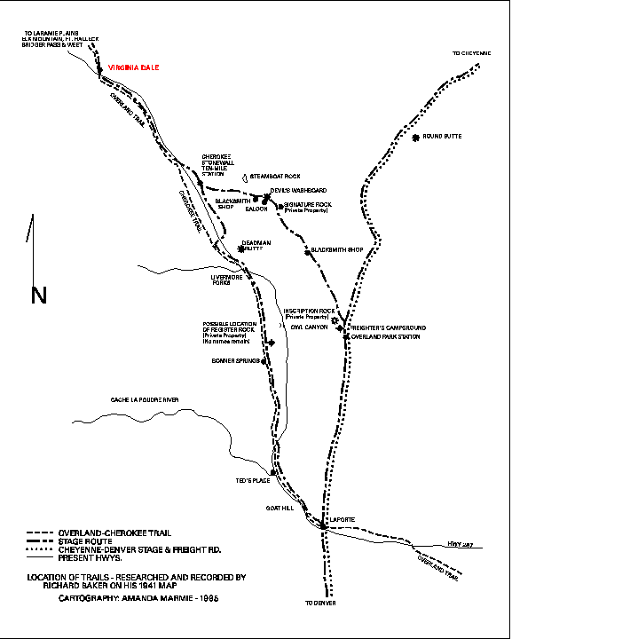
Map of stage stations from LaPorte to Virginia Dale
Map of stage stations from LaPorte to Virginia Dale
The LaPorte Station, which was a home station and also had some repair shops, was located on the north bank of the Cache la Poudre River. Nothing remains of this site, although there is a monument near the bridge crossing the river on the present Overland Trail Road. LaPorte, meaning "the gateway" was aptly named as it is the gateway to all the mountainous regions in Larimer County. All travel from Denver north and then to the west absolutely had to cross the Cache la Poudre River. After 1864 a ferry was available at fifty cents per person. Wagons would sometimes have to be dismantled in order to take the ferry necessitating two trips. The Overland Stage fare from Denver to LaPorte was $20.00.Trail ruts are still visible in many places along this stretch of the Overland Trail. Traveling north along US Highway 287, one sees them on the east side of the highway north of the Poudre Canyon Road (State Highway 14). Part of the trail here is used by local ranchers north of Livermore. The trail crosses US 287 several times between Livermore and Virginia Dale. In some spots, a double row of pine trees has been established along the ruts.
BONER The Bonner Springs Station, a swing station, was located 10 miles north of LaPorte at the site of some springs, just south of Owl Canyon. It was originally called "Boner Station." Several diaries refer to a Dr. Boner who nursed Jack Slade back to health after he was shot at Julesburg by Jules Beni. The name was later changed, it is thought, by emigrants who had traveled through Kansas on their way west. They began to call it Bonner Springs, after Bonner Springs, Kansas. There were springs nearby and it was a favorite camping spot for emigrants. It also became a hideout for the famous Musgrove Gang whose favorite target was government horses. In 1863 when the route was moved a little to the east to the Park Creek Station, it was pretty much abandoned. Just south of the station was an old grave site with a headstone having the inscription "E. Hale died April 17, 1864. Age 19 months." It's believed that this child's name was "Eddie." This headstone is no longer there, having been removed for "safe keeping." Nothing remains of the station either, although remains of three foundations near the spring are evident.
PARK CREEK The Park Creek Station was located on the "new" Overland Trail as established in 1862. This was located about three miles or so to the east of the Cherokee Trail and the Bonner Springs Station. The Park Creek station, built by Ben Holladay on the banks of Park Creek, was unique along this stretch of the trail in that it had a tunnel dug from the station to the barn which served as a refuge during the Indian problems. The first station, built of logs, was destroyed by Indians. A second station was built which could accomodate overnight travelers. Nothing remains of either station except some rubble, nails, and broken glass.
About four miles or so north of the Park Creek Station, and across the creek, was a large grassy area in the shape of an amphitheater. Wagon trains camped at this spot, approximately one mile square and surrounded on three sides by mountains. This was called the "Horseshoe." The trail split here, with one route going mostly north to Cheyenne, and the other going more north-west through the hills back towards Virginia Dale. A blacksmith shop was located near here on a little level area in the hills. Many wagons climbing the steep hills in this area found the blacksmith shop a welcome service, both for their wagons which may have broken down on the rugged trail, and any horses that needed to be re-shod.
SIGNATURE ROCK Keeping on the route north to Virginia Dale, the trail goes down to Spring Gulch, passes many Indian Teepee Rings, and then on to Signature Rock, where even today names can be read in the sandstone that were carved 150 years ago. The stages then encountered one of the steepest sections of the Overland Trail. Named "Devil's Washboard," it is a steep, rocky incline--bad in both directions. A welcome sight for many drivers and passengers alike at the bottom of Devil's Washboard, was a saloon. The foundation still remains. This is the historically rich area that has been the "Robert's Ranch" for over 100 years. (Note: That portion of the trail from north of the Horseshoe, up past Spring Gulch and the teepee rings, to north of Signature Rock is where a mining company is proposing to strip mine. Please visit that page, read the information, and e-mail your opposition to the Larimer County officials named.)
CHEROKEE The Cherokee or Ten Mile Station was located just to the west of the sandstone formation of Steamboat Rock on Ten Mile Creek, or Stonewall Creek--both names apply. Steamboat Rock is a landmark that can be seen for many miles along the present highway. Some reports say that the Cherokee Station was also burned by Indians, but when the DAR erected a granite marker on the site of the station in 1989 in memory of a local historian, they dug post holes for the base of the marker and found no evidence of charcoal, indicating that the station was probably not burned.
Twelve miles north of Cherokee Station, the stage reached Virginia Dale, the most noted stage station on the Overland Trail, and the last one in Colorado Territory. Jack Slade, the notorious station master at Virginia Dale, named the station for his wife, Virginia.
Right on the Wyoming/Colorado border along Highway 287 where the Overland Trail crossed, is a granite marker placed by the DAR on July 4, 1917.

Send comments, suggestions or inquiries:
Overland Trail
[Overland Trail | Stations and Stops | Links | Virginia Dale]
Created and maintained by Elizabeth Larson
Copyright © 1996-2000 All Rights Reserved