(1814), Mundy's Point
A local militia fort at the mouth of the Yeocomico River. Attacked by the British.
Fort Abbott |
Battery Alexander |
Fort Alvis |
Fort Archer |
Bellona Arsenal |
Bacon's Castle |
Fort Blaisdell
Camp Bottoms Bridge |
Fort Brady |
Fort Bross |
Fort Burnham |
Camp Byron |
Fort Charles (2)
Chesterfield C.H. |
Fort Christanna |
Fort Clark |
Fort Clifton |
Colquitt's Salient |
Fort Conahey
Fort Converse |
Fort Craig (2) |
Fort Cummings |
Battery Dantzler |
Fort Darling |
Fort Davis
Fort Davison |
Fort Drake |
Drewry's Bluff Battery |
Fort Dushane |
Fort Dutton |
Battery Eight |
Elliott's Salient
Fort Emory |
Battery 55 |
Fort Fisher |
Battery Five |
Battery 40 |
Battery 45 |
Battery 47
Flowerdew Hundred Fort |
Fort Friend |
Frontier Post |
Fort Gilmer |
Fort Gould |
Gracie's Salient |
Fort Graves
Fort Gregg (1) |
Fort Gregg (2) |
Fort Gregg (3) |
Fort Harrison (2) |
Fort Haskell |
Fort Alexander Hayes
Fort Hell |
Citie of Henricus |
Fort Henry (2) |
Fort Hill |
Fort Hoke |
Camp Holly |
Fort at Hood's Bluff
Fort Howard |
Fort Howlett |
Howlett's Battery |
Fort Jackson (2) |
Fort James (2) |
Fort Johnson
Fort Keene |
Fort Kelly |
Fort King |
Fort Lee (2) |
Fort Lowry |
Fort Mahone |
Fort McGivery
Fort McHenry |
Fort McKeen |
Fort McMahon |
Fort Meikle |
Fort Merriam |
Fort Morris |
Fort Morton (2)
Mundy's Point Battery |
Fort Myers |
Battery Nine |
North Anna Battlefield |
Fort Nottoway |
Battery One
Parker's Battery |
Battery Pegram |
Fort Pocahontas (2) |
Fort Porter (2) |
Fort Powhatan |
Fort Prescott |
Fort Rice
Rive's Salient |
Fort Sampson |
Fort Sedgwick |
Fort Seibert |
Battery Semmes |
Signal Hill Battery |
Battery Sixteen
Smith's Fort (1) |
Staunton River |
Fort Stedman |
Fort Stevens |
Fort Stevenson |
Fort Sumter |
Fort Tracy |
Battery 20
Union Fort |
Fort Urmston |
Fort Wadsworth |
Fort Walker |
Fort Warren |
Fort Wead |
Fort Welch
Fort Wheaton |
Battery White |
Fort Whitworth |
Battery Wood
Northern Virginia - page 1 | Western Virginia - page 2
Southeastern Virginia - page 4
Mundy's Point Battery
(1814), Mundy's Point
A local militia fort at the mouth of the Yeocomico River. Attacked by the British.
Frontier Post

(1652 - unknown), near Caret
A settlement and trading post was established on the Rappahannock River in
Essex County. By 1660 every man was required to be armed for protection
against the Indians.
Fort Lowry

(1861 - 1862), near Wares Wharf
Located on the Rappahannock River near Tappahannock. This was essentially a
water battery built to prevent Union gunboats from proceeding to
Fredericksburg. The Union destroyed it a month after the Rebels abandoned
it. Confederate Camp Byron (1861) was nearby in Dunnsville before
the troops moved to the fort. The site of the fort was never preserved,
and the area is swampy.
North Anna Battlefield (park)
(1864), Doswell
Massive Confederate earthworks still survive. Info available from Richmond and Fredericksburg NPS centers, and Hanover County Parks Dept.
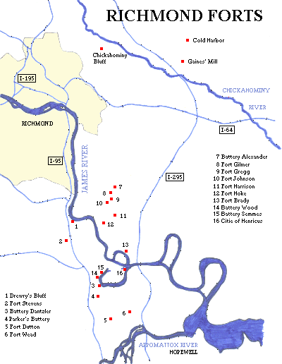
Richmond Civil War Forts
(Richmond National
Battlefield Park)
(1862 - 1864), Richmond View Richmond map
The main park includes the 1864 Union forts of Battery Alexander, Fort Gilmer, Fort Gregg (1), Fort Johnson, Fort Harrison (2) (originally CSA Fort Burnham), Battery White, Fort Hoke, Fort Brady, plus several other small unnamed batteries and miles of earthworks. All of these except Fort Brady were originally CSA works that were captured. Battlefield Tour Map Fort Wead is now part of the Chesterfield County Park System, located in a subdivision. There was also Fort Jackson (2), and Fort Drake, now mostly demolished by Route 10.
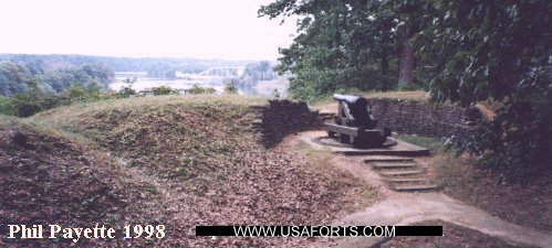
Outside the main park lies the CSA forts of Drewry's Bluff (1862 - 1865) (aka Fort Darling)
PHOTO, and Parker's Battery (1864). Drewry's
Bluff also served as the Confederate Naval Academy and Marine Corps Camp of
Instruction through much of the war. Fort Stevens, Fort Wead, and Battery Dantzler (formerly Fort Howlett and Howlett's Battery), all from 1864, are part of the Chesterfield County Park System. There was also Battery Wood and Battery Semmes on the James River (see "Henricus" below). Fort Dutton was located closer to the Appomattox River. Cold Harbor Battlefield had six miles of Confederate earthworks, with about two miles that are nicely preserved along the tour route. Chickahominy Bluff also has earthworks remaining.
Also located in Richmond was a rebel training camp at the present-day Monroe Park, the Belle Isle Prison Camp on Belle Isle on the James River, and Libby Prison on Cary St.
Richmond was surrounded by three defensive fortification rings. The outer ring circled 10 miles out, for a length of about 65 miles. An intermediate line was four miles out, and the inner line just outside the city limits consisted of several "star" forts and breastworks. More research is needed to determine the names of these works. None of these works exist today.
Bellona Arsenal
(Ruins)
(1816 - 1837, 1863 - 1865), Richmond
Located on the south bank of the James River, just outside the city limits.
It was sold in 1837. The Confederate government leased it during the Civil
War. A privately owned weapons factory was first located here in 1810.
Citie of Henricus

(Henricus Historical Park)
(1611 - 1622), Dutch Gap
The palisaded settlement is currently under reconstruction. This was the
second settlement in the state. In 1622, Indians entered the fort and used the colonists' own weapons to slay them. Sir Thomas Dale used a Dutch fortification technique to dig a ditch and construct a palisade behind the ditch to protect the village. The land masses on either side of the ditch became known as "Dale's Dutch Gap".
Signal Hill Battery (1864) was located across the river from where Union
troops were building the Dutch Gap Canal. The canal was to be a shortcut through the winding James River, cutting off nearly five miles - and bypassing this Confederate battery and also Batteries Howlett, Wood, and Semmes (mentioned above in the Richmond section). The Rebels were constantly firing on the Union troops and caused numerous delays of the canal's construction. The war ended before construction was complete. The canal was finished in 1871 and a lighthouse was built here. The park is open daily. The reconstructed area is open Thursday through Sunday.
Chesterfield Courthouse

(1780 - 1781), Chesterfield C.H.
A training post and encampment for all reinforcements for the Continental
armies from the southern states.
Camp Bottoms Bridge
(1814), Henrico County
A large state militia camp on the Chickahominy River.
Fort James (2)
(1645), Providence Forge
Located in New Kent County. It was built after the great Indian massacre of
1644 in which several hundred colonists perished.
Fort Pocahontas (2)
(1864 - 1865), Charles City
A Union supply depot built and manned by Negro soldiers, attacked in 1864. It was given its name after the battle. It has been reconstructed at Wilson's Wharf, adjacent to Sherwood Forest Plantation.
Flowerdew Hundred Fort
(1619 - 1622),
Located opposite the future site of Fort Powhatan.
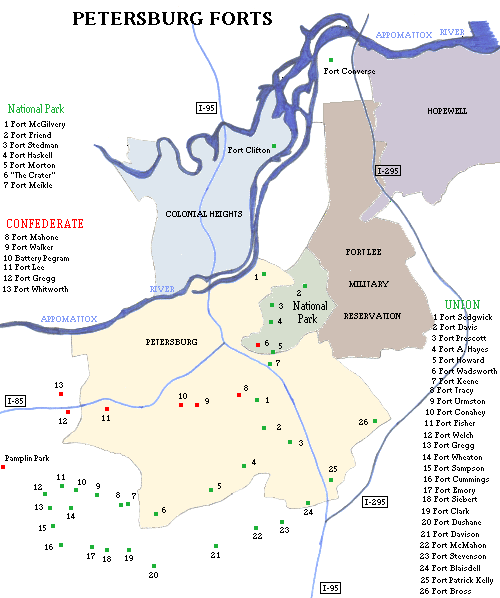
Petersburg & Hopewell Civil War Forts
(Petersburg National
Battlefield)
(1864 - 1865), Petersburg View Petersburg map
The main park includes Union forts Fort Friend, (originally CSA Battery 8), Fort Stedman, Fort Haskell, the site of Fort Morton (2), and the CSA forts Battery 5 (site of the Union Dictator mortar battery), Battery 9, Gracie's Salient, Colquitt's Salient, and "The Crater" which is the remains of a small CSA fort that was part of Elliott's Salient. Plus there are several other unnamed batteries. Admission fee. Battlefield Tour Map
Along Flank Road lies Union seige line forts including Fort Davis (aka
Fort Warren), Fort Alexander Hayes, Fort Howard, Fort
Wadsworth, Fort Keene, Fort Tracy, Fort Urmston,
Fort Conahey, and Fort Fisher.
Other Union seige line forts included Fort McGivery, Fort Meikle, Fort Rice, Fort Sedgwick (aka Fort Hell), Fort Welch, Fort Gregg (3) (USA), Fort Sampson, Fort Wheaton, (originally CSA Fort Archer), Fort Cummings, Fort Emory, Fort Seibert, Fort Clark, Fort Dushane, Fort Davison, Fort McMahon, Fort Stevenson, Fort Blaisdell, Fort Patrick Kelly, Fort Prescott, Fort Bross, and many other unnamed batteries. Siege of Petersburg.
Confederate defense line forts included Battery 1, Battery 16 and Battery 20 (part of the Dimmock Line), Rives' Salient, Fort Mahone, Fort Walker, Battery Pegram, Battery 40, Fort Lee (2) (aka Battery 45)(no relation to the current military reservation), Battery 47, Fort Gregg (2) (CSA), Fort Whitworth, Battery 55, and many other unnamed batteries.
Other forts in the area included CSA Fort Clifton, on the Appomattox
River in Colonial Heights, and Union Fort Converse between Petersburg and Hopewell, at a federal reformatory near the I-295 bridge.
Another interesting site nearby is Pamplin Historical Park, which also has the National Museum of the Civil War Soldier (admission fee). Several Confederate trenchworks are located here, as well as artillery emplacements, and camp sites.
At City Point in nearby
Hopewell
was Union Fort built to protect the supply depot in 1864 and 1865. Other Union forts around Hopewell included Fort Abbott, Fort Craig (2), Fort Graves, Fort McKeen, Fort Lewis O. Morris, Fort Merriam, Fort Gould, and Fort Porter (2).
Fort Henry (2)
(1645 - 1675), Petersburg
This was a frontier fort and trading post at the falls of the Appomattox River. It was garrisoned again in 1675. Location probably at or near McKenzie Street Park.
Fort Charles (2)
(1644 - unknown), near Hopewell
Built at the head of navigation on the James River somewhere in the vicinity of
Hopewell.
Fort Powhatan

(1781 - 1864, intermittent), Prince George County
Fort at Hood's Bluff was here in 1781 and was built over the site of an old Indian fortification. The next fort was built beginning in 1808. It was a masonry fort with a water battery. It was no longer in use by 1850, and the Confederates used the site beginning in 1862. The Union captured it in 1863.
The water battery no longer exists and the brick fort was most likely buried
under the Confederate earthworks. Located on the James River just downriver from Flowerdew Hundred Plantation. On private property.
Smith's Fort (1)
(Smith's
Fort Plantation)
(1609 - 1614?), near Surry
The fort, also known as New Fort, was built on a bluff above Gray's
Creek as a retreat from possible Indian attacks at Jamestown. The 18th-century plantation's mansion took the same name. A trail leads to the site of the old fort. The small site is protected on three sides by bluffs and traces of earthworks protect the land approach. Admission fee.
Bacon's Castle
(1676), Bacons Castle
This house was built in 1655. Rebels seized and held it for three months in
1676. It was captured by sailors from a ship in the James River who were
engaged in putting down the rebellion. Admission fee.
Fort Christanna
(1714 - unknown), Lawrenceville
Used by the Virginia colonial militia. It was built for protection of settlers and friendly Indians against the Tuscarora. It was a sister fort to Fort Germanna (see listing on the Northern Virginia page). A school for the Indian children was established here. The fort was eventually abandoned. In 1924 the site was marked by a cannon, one of five from the stockade.
Fort Nottoway
(unknown), near Blackstone
Located on the Nottoway River.
NEED MORE INFO:
NOTE: The second settlement of Richmond (1676) was a fortified community
and trading post on the south bank of the James River.
Other possible forts in the Richmond area include Fort McHenry,
Fort King and Fort Hill in western Henrico County, Fort Alvis and Camp
Holly in eastern Henrico County, Fort Sumter in western Chesterfield
County, a Fortview Drive in eastern Chesterfield County, and Fort Myers in central Hanover County. There is also a Battery Park in the City of Richmond.
A possible fort location in Colonial Heights at Battery Place.
 Books about Forts in Virginia