(1861 - 1864), Winchester
A redoubt used during the Third Battle of Winchester in 1864.
Albemarle Barracks |
Banks' Fort |
Bellefont |
Big Crab Orchard Fort |
Black's Fort |
Fort Blackmore
Fort Blackwater |
Boone Cabin |
Reese Bowen's Fort |
Bowman's Fort |
Fort Braddock |
Fort Breckenridge
Brock's Gap Fort |
Burke's Fort |
Burner's Fort |
Byrd's Fort |
Carter's Fort |
Fort Chiswell |
Fort Christian
Fort Collier |
Colonial Fort (c) |
Crisman's Fort (1) |
Crissman's Fort (2) |
Fort Cunningham |
Davis' Fancy
Fort Defiance |
Dickerson's Fort |
Fort Dickinson |
Fort Dinwiddie |
Dortor's Fort |
Dunkard Bottom |
Fort Early
Fort Egypt |
Elk Garden Fort |
Faris Station |
Fort Fauquier |
Froman's Fort |
Fort George (2) |
Fort George (3)
Gibson Station |
Glade Hollow Fort |
Harmony Hall |
Fort Harper |
Harrison's Fort (1) |
Heiston's Fort |
Hite's Fort
Holman's Fort |
Houston's Fort |
Hupp's Fort |
Fort Edward Johnson |
Kauffman's Fort |
Keller's Fort |
Keyser's Fort
Kilgore's Fort |
Fort Lee (1) |
Fort Lewis (1) |
Fort Lewis (2) |
Fort Lewis (3) |
Locust Grove |
Paul Long's Fort
Philip Long's Fort |
Fort Loudoun |
Camp Lupton |
Fort Lynne |
Madison Hall |
Madison's Fort |
Maiden Springs Fort
Fort Mann |
Martin's Fort |
Fort Massanutten |
Fort Mayo |
Fort McCausland |
McClelland's Station
Miller's Fort (1) |
Fort Miller (2) |
Fort Milroy |
Moore's Fort |
Old Fort |
Painter's Fort |
Patterson's Fort
Audley Paul's Fort |
Fort Pearis |
Porter's Fort (1) |
Powell's Fort |
Roads' Fort |
Rhodes' Fort |
Royal Oak
Russell's Fort |
Rye Cove Fort |
Saltville Earthworks |
Sapling Grove |
Fort Shenandoah |
Smith's Fort (2)
Smith's Island Fort |
Star Fort |
Staunton River Fort |
Steele's Fort |
Stephen's Fort |
Old Stone Fort
Stone Church Fort |
Stover's Fort |
Strickler's Fort |
Terry's Fort |
Fort Trial |
Fort Turley |
Vass' Fort
Fort Vause |
Warwick's Fort |
White's Fort |
White Hall |
White House |
Fort William |
Wilson's Fort
Witten's Fort |
William Wynne's Fort |
Wolf Creek Village |
Wolfe's Fort |
Fort Young
Northern Virginia Forts - page 1 | Central Virginia Forts - page 3
Southeastern Virginia Forts - page 4
Fort Collier
(1861 - 1864), Winchester
A redoubt used during the Third Battle of Winchester in 1864.
Star Fort

(1862 - 1864), Winchester
Originally built in 1862 by Federal forces, but abandoned after only a few months.
This was a hilltop defense that was captured by the Union during the Third Battle
of Winchester in 1864.
Fort Milroy
(1863), Winchester
A hilltop fortification in a chain of defenses controlling the crossing of
Opequon Creek. Of interest nearby is Stonewall Jackson's Headquarters Museum. Admision fee.
Banks' Fort
(1862), Strasburg
A Confederate hilltop defense. Nearby is the Stonewall Jackson Museum at Hupp's Hill, located by Confederate earthworks from the 1864 campaign. Admission fee. Also of interest here is Crystal Caverns, which was used in the Civil War for ammunition storage.
Smith's Island Fort

(1725 - unknown), Madison
A fort and stockade built by the German settlers after moving away from the Germanna settlement. This structure was also used as a church. Site was located on the north side of the Robinson River by White Oak Run, north of town. The White Oak Run was originally known as Smith's Run, and there was once an island at the convergence of the two rivers, hence the name.
Albemarle Barracks

(1779 - 1780), Charlottesville
A prisoner-of-war encampment for 2,577 British and 1,882 Hessian troops that were captured at Saratoga, NY in 1777. They were previously kept in Boston, but were moved to a warmer climate. The officers were quartered in private houses within a twenty-mile radius. As the British army moved northward from North Carolina, the remaining prisoners (about 2,000 after death, desertions and exchanges) were moved to Hagerstown, MD. No remains of the encampment site are left. Located northwest of downtown, north of Ivy Creek.
Fort Edward Johnson
(1862 - 1864), Headwaters
An earthwork fort that was abandoned when General Johnson decided to
instead occupy Shenandoah Mountain to the east.
Fort Early
(1864), Lynchburg
A redoubt that was part of the outer defenses. Union forces unsuccessfully
attacked it soon after it was built. Earthworks can still be seen, located at Memorial and Fort Aves., enclosed within a brick wall. A brick building inside the redoubt is the Fort Hill Women's Club.
Fort McCausland
(1864), Lynchburg
A hilltop defense to protect the westward approach. A Union cavalry unit
skirmished near here with forces from this fort. The Federals were driven
back. A military road connected a nearby redoubt to this fort.
Staunton River Fort
(Staunton River Battlefield State Park)
(1864), Randolph
Confederate earthworks and a small fort remain on a walking trail in the park. The fort was built to protect the railroad bridge across the river. The bridge was held after the battle, but was burned in 1865 on Lee's retreat to Appomattox. The current bridge was built in 1902.
Fort Chiswell
This was a military outpost until 1776 and is marked by a pyramid of boulders.
It was built for expeditions against the Cherokee. After 1776, it served as the
county seat of Montgomery County, and as a defense for the local lead mines. The lead was needed to make shot (gun bullets).
South of here, at Poplar Camp, is Shot Tower Historical State Park (1807 - 1860's), one of only three remaining shot towers still in existence in the U.S.. Admission fee.
Wolf Creek Indian Village

(1215), Bastian
A reconstructed Indian palisaded village of the Late Woodland Culture, with artifacts on display in the museum. Operated by the Bland County Historical Society. Admission fee.
Saltville Earthworks
(1864), Saltville
Six-feet high earthworks along a hiking path off of Walnut Street.
Kilgore's Fort
Scott
County Attractions
(1786 - 1790's), Nickelsville
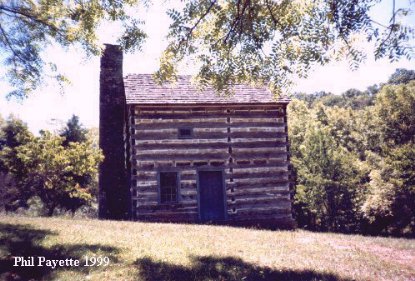
Located on Copper Creek, it is the sole survivor of 12 forts ranging from Cumberland Gap to Castlewood. This is a house built for defense against Indians. It was rebuilt in 1974. Robert Kilgore was a preacher and often held religious services here. Another website at a local school. PHOTO
See the "Scott County" section below for other nearby forts.
Black's Fort
(1774 - 1781), Abingdon
The local townspeople took refuge here during Indian raids. The first
Washington County court meeting was held here in 1777. It continued to
be the courthouse until 1778.
Carter's Fort
(1774 - 1794), Rye Cove
Located in Scott County, it was a fortified trading post on the Wilderness
Road, which ran from North Carolina to Kentucky. It was originally called
Crissman's Fort (2) until 1776, and later Rye Cove Fort. The fort
was rebuilt in 1777 by the Virginia state militia, who occupied it until at
least 1794, and renamed it Fort Lee (1).
McClelland's Station ?
(1770's - 1780's), Scott County
Faris Station
(1780's - 1791), Gate City
Destroyed by Indians.
Other Western Virginia Forts
There were 22 Virginia militia forts built in 1755 - 56 from Fort Cumberland, MD, on the Potomac River, to Fort Mayo near the NC border, roughly 10 - 30 miles apart. Other previously built settlers' forts were also used by the militia.
Information on French & Indian War forts of the Potomac River basin was gathered from "Frontier Forts along the Potomac and its Tributaries" by William H. Ansel, Fort Pearsall Press, 1984.
City of Winchester:
Winchester: Fort Loudoun (1756 - 1758), the frontier headquarters of the Virginia colonial militia. It was an earthern redoubt with four bastions and armed with 18 guns. Construction was halted in 1758. The guns were removed, save one, in 1775. British and Hessian POWs were kept here 1780 - 1783. The earthworks were still visible in 1838. The site was just north of the old town area. George Washington's Office Museum, a log house built in 1748 and located on Cork Street, was where Washington supervised the fort's construction. Admission fee. The town was originally named Fredericktown.
Frederick County:
Green Spring: Patterson's Fort (1754 - 1760's), a settlers' fort that was also used by the VA colonial militia. Located 10 miles northwest of Fort Loudoun.
Gainesboro: Fort Pearis (1755 - 1760's), a VA colonial militia fort located on Hogue Creek.
Shawnee Land: White's Fort (1755 - 1760's), a settlers' stockaded house on Hogue Creek that was built in the 1740's. It was also known as White Hall.
Mountain Falls or Marlboro: Froman's Fort (1755 - 1760's), a stone house built in 1751.
Stephens City: Hite's Fort (1755 - 1760's), ruins of a settler's stone house built in 1753.
Stephens City: Crisman's Fort (1) (1755 - 1760's), a stone house built in 1751, located two miles south of town. The town was formed as Stephensburgh in 1758.
Middletown: Old Stone Fort aka Stephen's Fort (1756 - 1760's), built for protection from Indians, still exists. It is a small whitewashed hexagonal stone house.
Cedar Creek: Bowman's Fort aka Harmony Hall (1755 - 1760's), a stockaded stone house built in 1751, still exists.
Shenandoah County:
Strasburg: Hupp's Fort (1755 - 1760's), a stone house that was used as a fort during Indian attacks, still exists. Three miles south of Bowman's Fort.
Fort Valley: Powell's Fort (1740's ?), unknown exact location. The valley takes it's name from this fort.
Woodstock: Miller's Fort (1) (1756 - 1760's), a settlers' fort. Woodstock was founded in 1761.
St. Davids Church or Carmel: Keller's Fort (1750's - 1770's), a settlers' fort on Passage Creek.
Lantz Mills: Wolfe's Fort (1755 - 1760's), a settlers' stockaded blockhouse on Stony Creek.
Hamburg: Painter's Fort (1750's - 1758), a log house with a deep fortified cellar, located at the head of Painter Run. It was attacked and destroyed.
Forestville: Holman's Fort (1750's - 1760's), a settlers' fort.
Page County:
Springfield: Rhodes' (or Roads') Fort (1760's), a settlers' log house over a fortified stone cellar, located on west side of river from town. Attacked in 1766, all killed.
Springfield: Keyser's Fort (1750's), a settlers' home on the west bank of the river.
Springfield: Stover's Fort (1760), a settlers' fort on Sandy Hook, directly opposite from Rhodes' Fort.
Springfield: Heiston's Fort (1750's), a settlers' home near Bixley's (Bixlers) Ferry.
Hamburg: Kauffman's Fort, aka White House (1760), a fortified stone cellar, still exists.
Salem: Strickler's Fort aka Fort Egypt (1750's - 1760's), a fortified stone cellar located at Egypt Bend, opposite Hamburg.
Salem: Fort Massanutten aka Locust Grove (1750's), a settlers' fort on the west bank of the river.
Salem: Paul Long's Fort (1750's - 1760's), a fortified stone cellar, built in 1740 (?), located on the west bank of the river.
Salem: Philip Long's Fort (1750's - 1760's), a fortified stone cellar, built in 1740 (?). The house still exists. Located on the east bank of the river.
unknown location: Burner's Fort (1750's), a settlers' home near Ruffner's Ferry (location?). Possibly near Burner Bottom near the Warren County line.
Rockingham County:
Coote's Store: Brock's Gap Fort (1750's - 1760's), a VA colonial militia fort.
Turleytown: Fort Turley (unknown).
Green Mount: Fort Lynne (unknown).
Dayton: Harrison's Fort (1) (1755 - 1760's), a stockaded stone house that served as a refuge for settlers from Indian attacks. Built in 1748. It was restored in the 1980's, and is operated as a museum by the Harrisonburg-Rockingham Historical Society.
Port Republic: Madison's Fort (1755 - 1760's), a stockaded stone house, also known as Madison Hall.
Augusta County:
Fort Defiance: Augusta Stone Church Fort (1755 - 1760's), a stone church built in the 1740's that was stockaded for the protection of settlers. Still exists. It is uncertain if this is the Fort Defiance the town is named for.
City of Staunton:
Staunton: Fort Lewis (2) also known as Bellefont (1755- 1760's), a stone house built in 1732, still exists. It was in use by the VA colonial militia.
Highland County:
north of McDowell: Fort Harper (1750's), on Bull Pasture River.
McDowell: Fort George (2) (1757), an 80-square-foot log fort (still
exists).
Vanderpool: Fort Miller, aka Miller's Fort (2) (1750's), on the Jackson River.
Bath County:
Bacova: Fort Dinwiddie aka Byrd's Fort aka
Warwick's Fort (1755 - 1760's), used by the Virginia colonial militia.
Fort Lewis: Fort Lewis (1) (1756 - 1760's), a small stockade
first known as Wilson's Fort, used by the Virginia colonial
militia. Also known as Lewis' Hog Pen, and later as Fort Lewis Plantation.
Millboro Springs: Fort Dickinson (1756 - 1760's), used by the Virginia colonial militia, attacked by Indians in 1756 and 1757.
Alleghany County:
Falling Spring: Fort Breckenridge (1756 - 1763), used by the
Virginia colonial militia, it survived an attack by Shawnee Indians during
Pontiac's War in 1763.
Covington: Fort Young (1756 - 1763), used by the Virginia
colonial militia. A relief force that was sent to Fort Breckenridge in
1763 was ambushed by Indians. This fort started the settlement of Covington.
unknown location: Fort Mann (1763), used by the Virginia
colonial militia.
Rockbridge County:
Steele's Tavern: Steele's Fort (1756 - 1763), a stone house used as a refuge for settlers. Still exists. The Kerr Creek Massacre took place 15 miles southwest of here in 1763.
Botetourt County:
Amsterdam or Troutville: Fort William (1756 - 1763), used by the Virginia colonial militia, attacked by Indians in 1756. Settlers took refuge here during Pontiac's War in 1763.
Buchanan: Fort Fauquier (1758 - 1763), used by the Virginia
colonial militia, located on the James River.
Rocky Point (?): Audley Paul's Fort (1761 - 1763), a stockade fort where settlers took refuge during a Shawnee Indian raid.
Roanoke County:
near Vinton: Vass' Fort (1756 - 1760's), used by the Virginia colonial militia. The history is portrayed at Virginia's Explore Park on the Blue Ridge Parkway. (May be the same as Fort Vause in Montgomery County listing below.)
near Salem: Fort Lewis (3) (1756 - 1760's), located on the Campbell patent lands.
Glenvar (?): Fort George (3) (1750's), located on the Roanoke River.
Bedford County:
Montvale: Colonial Fort (c) (1756 - 1760's), a blockhouse built for protection against Indian attacks.
Franklin County:
Rocky Mount: Fort Blackwater aka Terry's Fort (1756 - 1760's), a stockade fort used by the Virginia colonial militia.
Henry County:
Stanleytown: Fort Trial (1756 - 1760's), used by the Virginia
colonial militia and intended as a place of refuge during Indian raids.
Patrick County:
Critz: Fort Mayo (1756 - 1760's), used by the Virginia colonial
militia. It was the southernmost of the Virginia military forts.
Montgomery County:
Shawsville: Fort Vause (1755 - 1760's), used by the Virginia colonial militia. It was attacked and burned by French and Indians in 1756, but
rebuilt a few months later. (May be the same as Vass' Fort in Roanoke County listing above.)
Pulaski County:
Dublin: Dunkard Bottom Fort (1756 - 1760's), first fort in Virginia
west of New River. The settlement was founded in 1750.
Tazewell County:
Pocahontas: William Wynne's Fort (unknown dates), a
neighborhood fort built on a hilltop. The settlement here was established
in 1752, and the fort was built sometime after that. After 1776, the
Virginia state militia built a fort here.
near Bluefield: Boone Cabin-Fort (1767 - 1768). Built by Daniel Boone. Later the site of Tazewell County's first courthouse. A farmhouse now occupies the site.
Tazewell: Witten's Fort (1767) and
Big Crab Orchard
Fort (1771 - 1774). Built as a neighborhood place of refuge. It was used
by the Virginia colonial militia for Lord Dunmore's War in 1774.
Now located here is the Historic Crab Orchard Museum & Pioneer Park.
Liberty: Maiden Springs Fort aka Reese Bowen's Fort
(1772). It was used by the Virginia colonial militia for Lord Dunmore's
War in 1774.
Burkes Garden: Burke's Fort (1774). Built as a defense
against Indians.
Smyth County:
Marion: Royal Oak (1769), a house that served as a
neighborhood fort. The first Smyth County court meeting was held here in
1832.
Atkins: Davis' Fancy (1748), a house that served as a
neighborhood fort.
City of Bristol:
Bristol: Sapling Grove (1770), a house used as a neighborhood
fort where settlers could seek refuge against Indian attacks.
Russell County:
Castlewood: Russell's Fort (1774), a hilltop defense that
was part of a chain of forts protecting settlers on the Clinch River during
Dunmore's War.
Lebanon: Glade Hollow Fort (1774), a Clinch Valley frontier
defense garrisoned by 21 men for Dunmore's War.
Elk Garden: Elk Garden Fort (1774), a Clinch Valley defense.
It is not known when the stockade fort was constructed, but it was used
in Dunmore's War, and it still exists. Elk Garden Church is next to the
site.
Rosedale: Smith's Fort (2) aka Fort Christian (1774), a
Clinch Valley defense.
St. Paul: Moore's Fort (1774), a Clinch River defense that
was ambushed by Indians. Daniel Boone and a group of settlers heading to
Kentucky once stopped here.
Scott County:
south of Nickelsville: Houston's Fort (1774). Cherokee Indians
attacked the fort in 1776. This is also the site of the first settlement
in Scott County (1769-1771). Located on Big Moccasin Creek.
Fort Blackmore: Fort Blackmore (1771). This was the first
permanent settlement in Scott County. The fort was unsuccessfully
attacked by Indians several times.
Dungannon: Porter's Fort (1) (1774), a fort house to protect
settlers from Indian attacks.
Nickelsville: Dortor's Fort (1770's), located near
Kilgore Fort House, it was built to protect residents from Indian attacks.
Robin Kilgore lived here. (spelled Dorton on one modern map)
Lee County:
Rose Hill: Martin's Fort (1768), a stockade
around five or six cabins. It was soon abandoned.
Cumberland Gap: Please see the page for Kentucky.
NEED MORE INFO: VA militia forts from the 1750's (these might be in WV) - Dickerson's Fort, Fort Cunningham (12 miles from Winchester).
ALSO: Danville had Civil War fortifications; Fort Braddock and
Old Fort in Winchester; Fort Shenandoah near Winchester; Camp Lupton at Woodstock; Stoney Battery Road in Troutville; Gibson Station near Cumberland Gap.
Towns: Fort Defiance, Fort Mitchell south of Keysville, Stony Battery in Smyth County.
 Books about Forts in Virginia