|
HOME
BATTLE OF CAMDEN PROJECT, MAP BIBLIOGRAPHY
Maps and Aerial Photographs
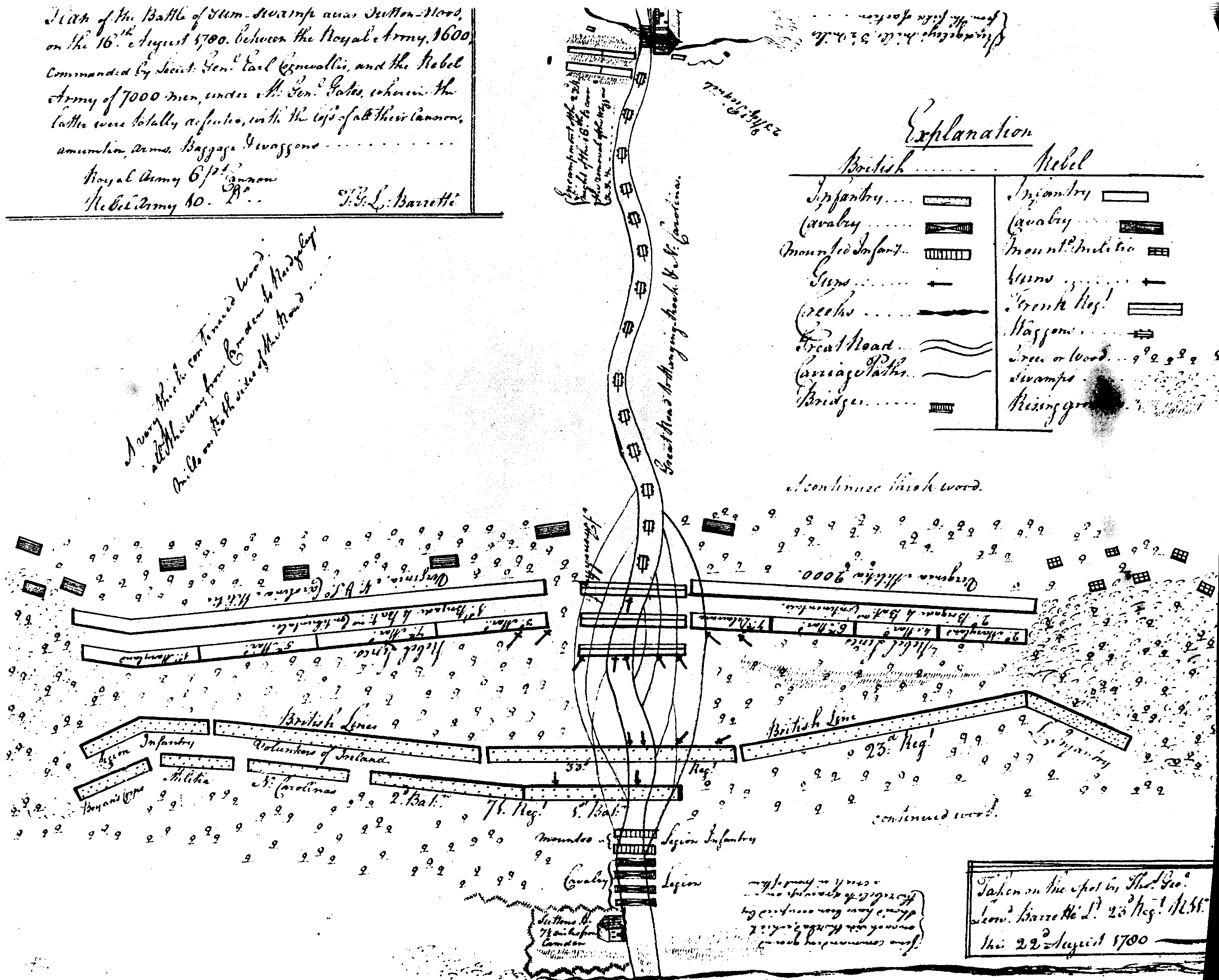
- BARRETT�: "Map of the Battle of Gum-Swamp alias Sutton-Ford, on the 16th August, 1780. between the Royal Army, 1600, commanded by Lieut. Genl Earl Cornwallis, and the Rebel army of 7000 men under M. Gen. Gates, wherein the latter were totally defeated, with the loss of all their Cannon, Amunition, Arms, Baggage & waggons..." "Taken on the spot by Thos Geoe Leond Barrett� Lt 23d Regt RWF this 22d August 1780. The Barrett� map is in the Clements Library at the University of Michigan, Ann Arbor. Lt. Thomas George Leonard Barrett� was a lieutenant in the 23d Regt.of Foot having served in the British Army 12 years before Camden and in the Americas since 1779. Submitted by: Charles Baxley. From:
LC Control Number: 75013657; Type of Material: Cartographic Materia; Personal Name: Marshall, Douglas W.; Main Title: Campaigns of the American Revolution : an atlas of manuscript maps / by Douglas W. Marshall and Howard H. Peckham. Published/Created: Ann Arbor : University of Michigan Press, c1976. Related Names: Peckham, Howard Henry, 1910- joint author. Description: v, 138 p. : maps (some col.) ; 34 cm. ISBN: 0472233009; Notes: Includes index. Subjects: Early maps--Facsimiles. United States--History--Revolution, 1775-1783--Campaigns--Maps. LC Classification:
G1201.S3 M25 1976; G1201.S3 M25 1976; Copy 1; -- Request in: Geography & Map Reading Room (Madison, LMB01) -- Status: Not Charged
- BARRON: Battle of Camden map drawn for Lord Percy by Ed. Barron. Sketch of the disposition and commencement of the Action near Camden in South Carolina 16th August 1780 as discribed in the Letters of the Right Honble Earl Cornwallis to the Secretary of State: and the Rebel General Gates to Congress. Most respectfully inscribed to The Right Honble Earl Percy, by his Lordships most Humble Servant Ed Barron.
See Offline maps. Pull-out map provided with Britt, Kent. "The Loyalists" National Geographic Magazine, Vol. 147 (April, 1975). Credit given as have once been part of the Duke of Northumberland Collection and that it is housed at the Public Archives of Nova Scotia. Submitted by Calvin Keys.
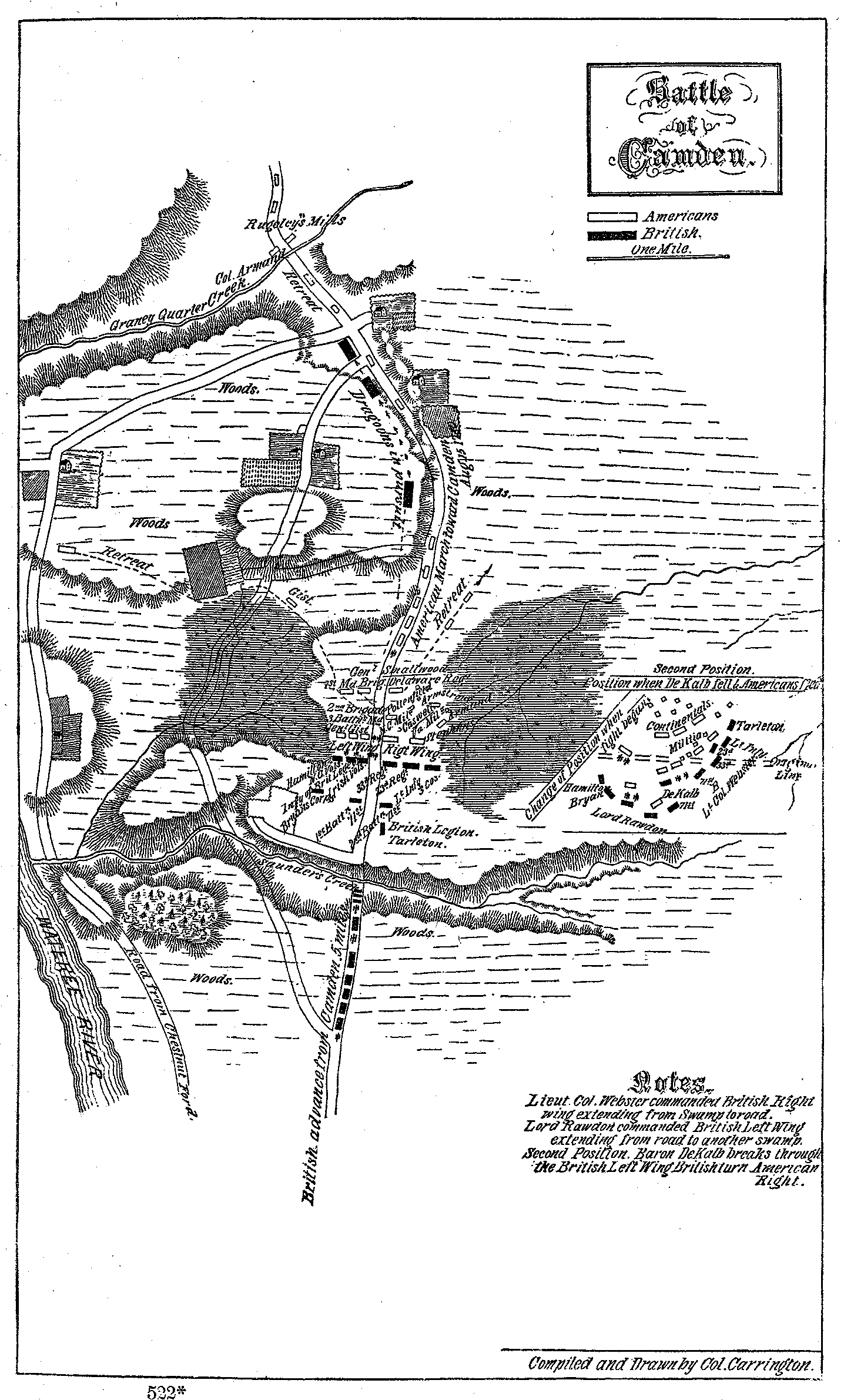
- CARRINGTON: Battle of Camden map from Col. Henry B. Carrington, Battles of the American Revolution, 1775-1781. Historical and Military Criticism, with Topographical Illustration, (New York: A.S. Barnes & Co., 1871, 1876)
See Maps.
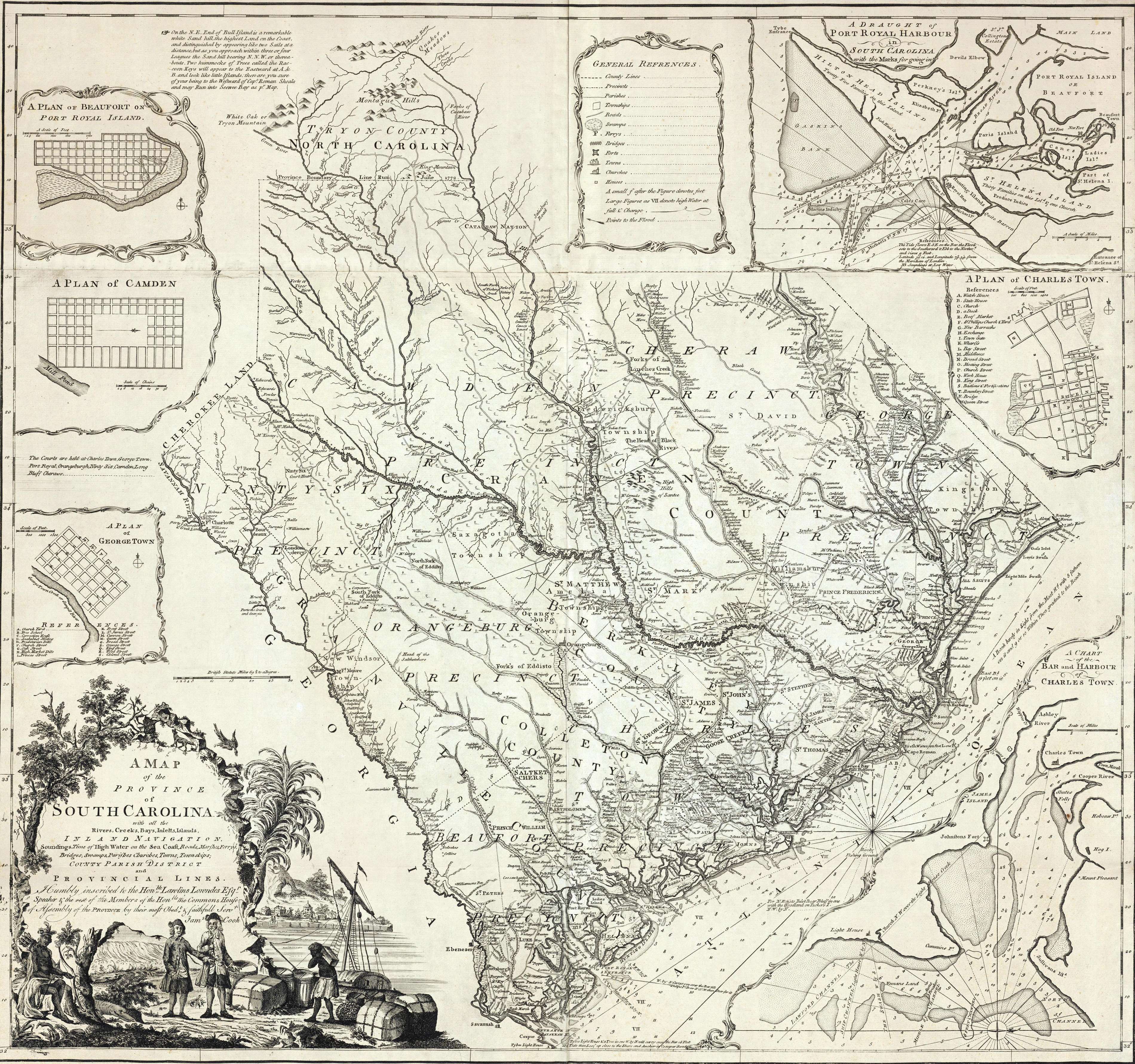
- COOK: A map of the province of South Carolina with all the
rivers, creeks, bays, inletts, islands, inland
navigation, soundings, time of high water on the sea
coast, roads, marshes, ferrys, bridges, swamps,
parishes, churches, towns, townships, county, parish,
district, and provincial lines. Humbly inscribed to the
Honble. Lawlins Lowndes, Esgr. ... by their most obedt.
& faithful servt. Jams. Cook. Thos. Bowen, sculpt.
LC Control Number: 74692124
Type of Material: Cartographic Material
Personal Name: Cook, James, 1728-1779.
Main Title: A map of the province of South Carolina with all the
rivers, creeks, bays, inletts, islands, inland
navigation, soundings, time of high water on the sea
coast, roads, marshes, ferrys, bridges, swamps,
parishes, churches, towns, townships, county, parish,
district, and provincial lines. Humbly inscribed to the
Honble. Lawlins Lowndes, Esgr. ... by their most obedt.
& faithful servt. Jams. Cook. Thos. Bowen, sculpt.
Published/Created: [London] Sold by H. Parker [1773]
Related Names: Bowen, Thomas, d. 1790.
Parker, H., fl. 1762-1773.
Description: col. map 76 x 81 cm.
Scale Information: Scale ca. 1:600,000.
Notes: Relief shown pictorially. Depths shown by soundings.
Annotated on verso: South Carolina.
Described in William Cumming's The Southeast in early
maps, no. 443.
Insets: A plan of Beaufort on Port Royal Island [ca.
1:17,000]--A plan of Camden.--A plan of Georgetown [ca.
1:17,000]--A draught of Port Royal Harbour in South
Carolina with the marks for going in [ca. 1:200,000]--A
plan of Charles Town [ca. 1:17,000]--A chart of the bar
and harbour of Charles Town [ca. 1:75,000]
Subjects: South Carolina--Maps--Early works to 1800.
Charlestown (S.C.)--Maps--Early works to 1800.
Georgetown (S.C.)--Maps--Early works to 1800.
LC Classification: G3910 1773 .C6 Vault
Geographic Class No.:
3910
3914 C3 G3
CALL NUMBER: G3910 1773 .C6 Vault
Copy 1
-- Request in: Geography & Map Reading Room (Madison, LMB01)
-- Status: Not Charged
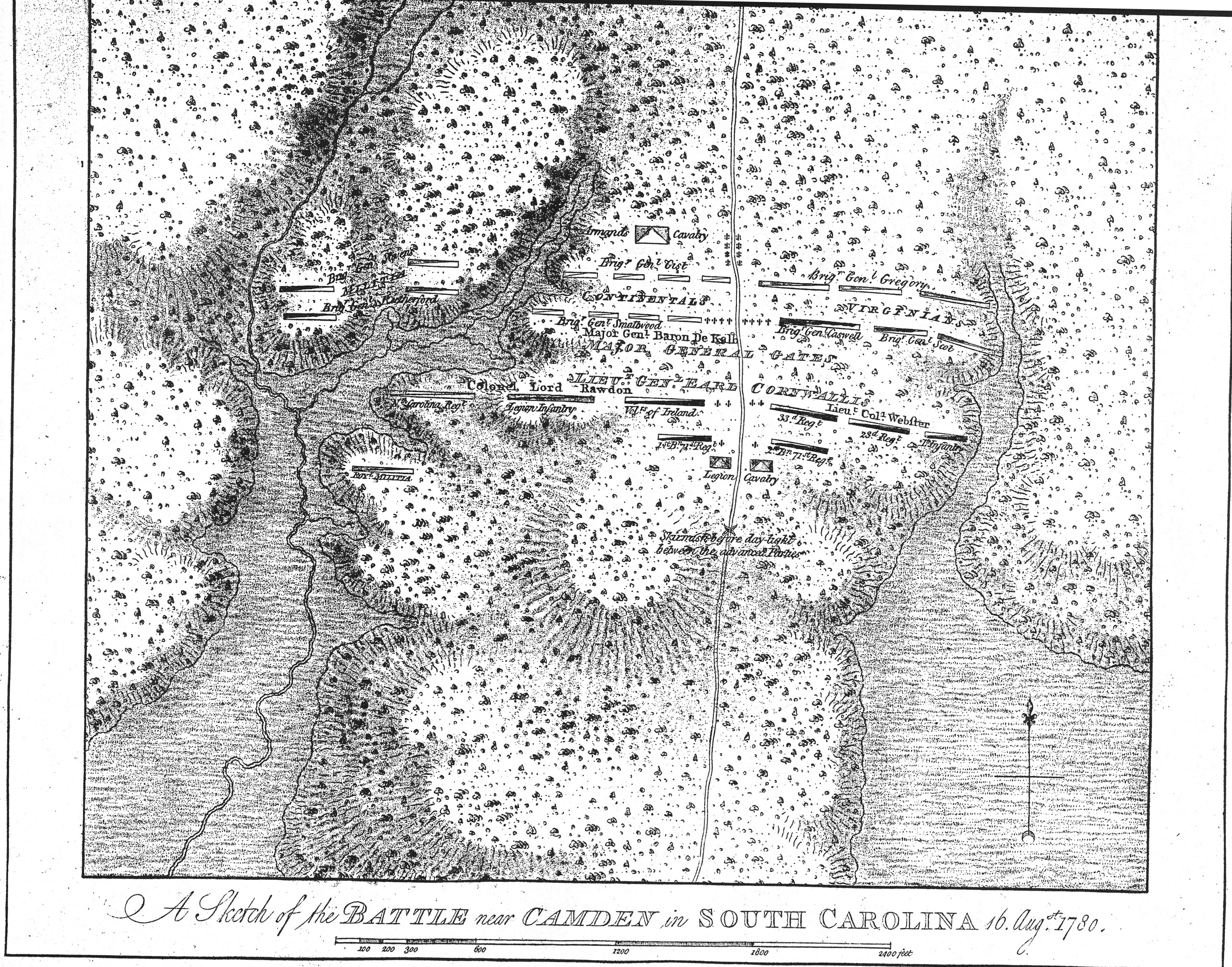
- DESBARRES [DesBarres] A Sketch of the battle near Camden in South Carolina, 16 Augst. 1780. Submitted by Sherri Bower.
LOC listing follows. LC Control Number: 73691876, Type of Material: Cartographic Material, Personal Name: [Des Barres, J. F. W. (Joseph Frederick Wallet)] 1722-1824., Published/Created: [London, 1780?], Description: col. map 29 x 33 cm., Scale Information: Scale ca. 1:4,800., Notes:Relief shown by shading and hachures, Subjects: Camden, Battle of, Camden, S.C., 1780--Maps--Early works to 1800, LC Classification: G3914.C2S3 1780 .D4 Vault, Geographic Class No.: 3914 C2, CALL NUMBER: G3914.C2S3 1780 .D4 Vault, Copy 1; Request in: Geography & Map Reading Room (Madison, LMB01), Status: Not Charged Commentary/Review
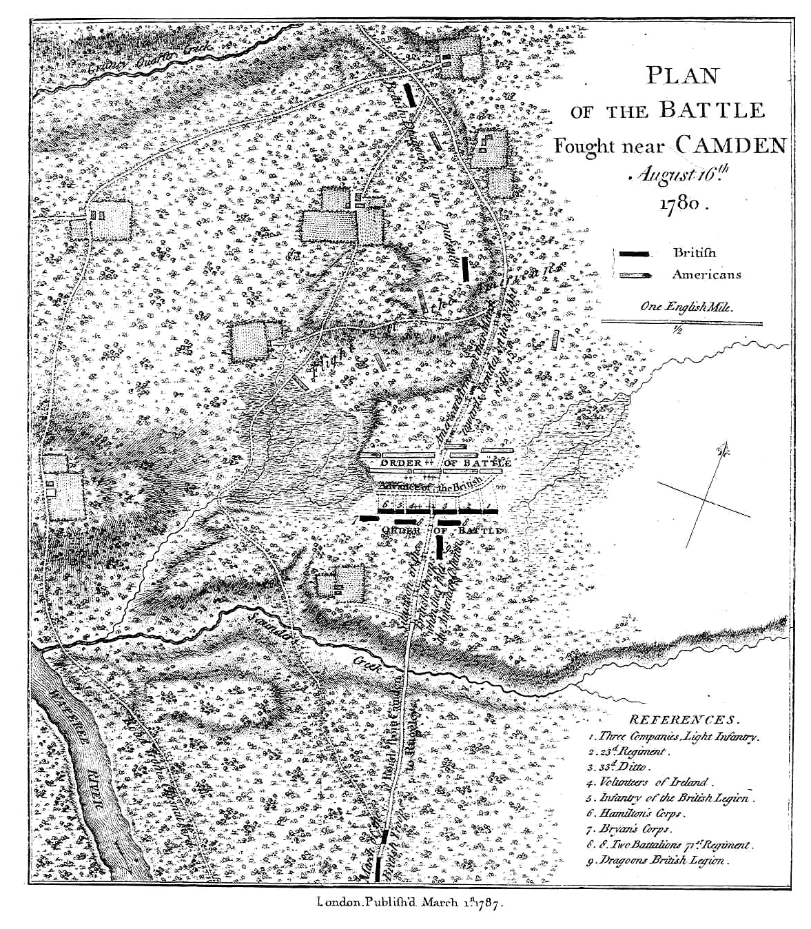
- FADEN:
- Plan of the Battle fought near Camden, August 16th,1780 by William Faden, Cartographer to King George III, (Original in the British Museum). See Maps (same as that in Tarleton's History...).
LOC listing follows. LC Control Number: gm 71000641; Type of Material:
Cartographic Material; [Faden, William] 1750?-1836; Main Title:
Plan of the battle fought near Camden, August 16th, 1780; Published/Created: London, 1787; Description: col. map 22 x 19 cm.; Scale Information: Scale ca. 1:41,500; Notes: Relief shown by hachures; Appears in William Faden's Atlas of the battles of the American Revolution. 1845; Subjects: Camden, Battle of, Camden, S.C., 1780--Maps--Early works to 1800; LC Classification:
G3914.C2S3 1787 .F3 Vault; Geographic Class No.: 3914 C2; CALL NUMBER: G3914.C2S3 1787 .F3 Vault, Copy 1; Request in:Geography & Map Reading Room (Madison, LMB01); Status: Not Charged.
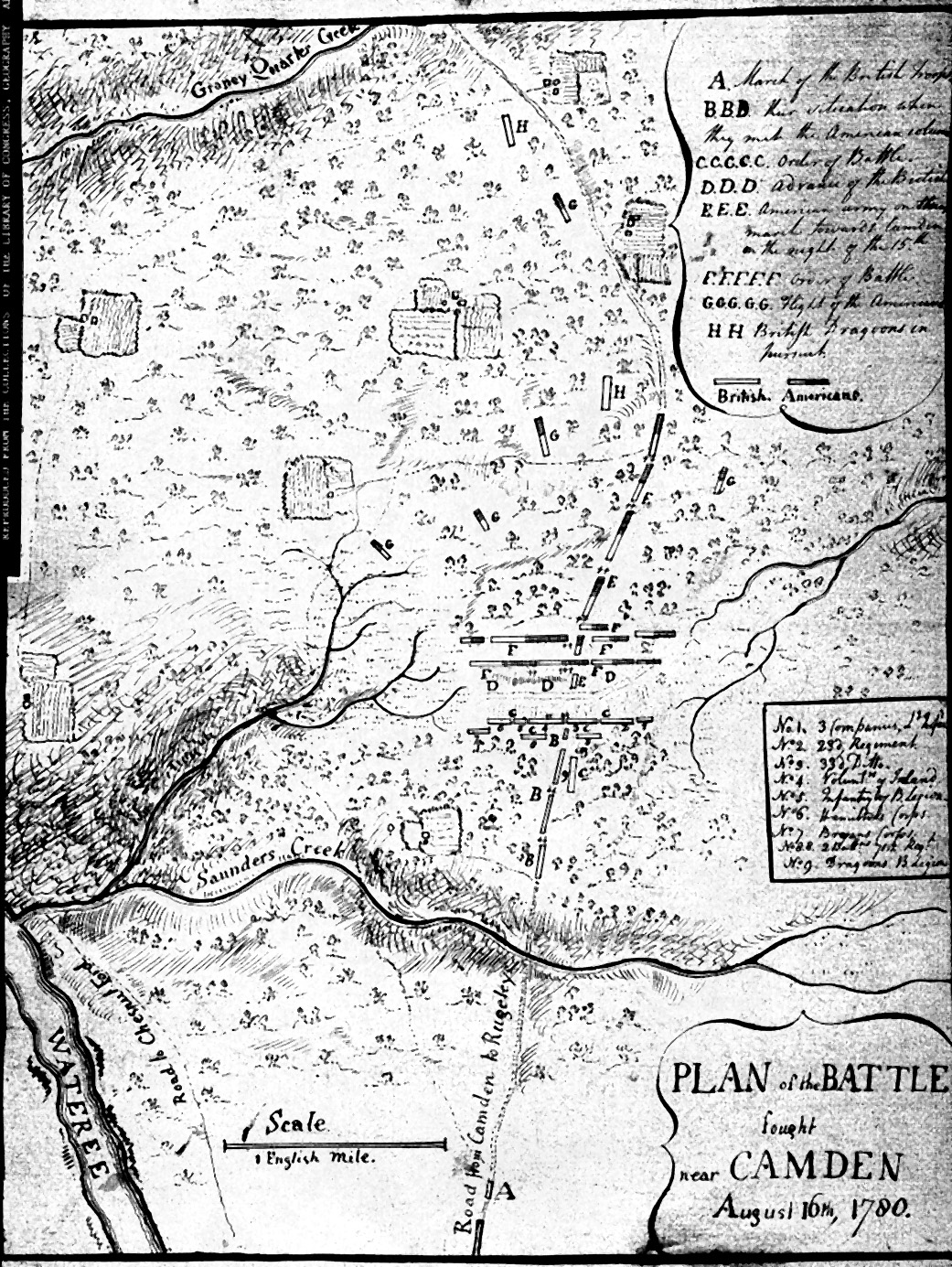
- Pen & ink map Pen & ink version of above, Submitted by Sherri Bower:
LOC listing
LC Control Number: gm 71000640;
Type of Material: Manuscript Cartographic Material;
Main Title: Plan of the battle fought near Camden, August 16th, 1780.;
Published/Created: [1780];
Description: map 36 x 28 cm.;
Scale Information: Scale ca. 1:25,500.;
Notes: Manuscript, pen-and-ink.;
Relief shown by hachures.;
Subjects: Camden, Battle of, Camden, S.C., 1780--Maps, Manuscript--Early
works to 1800.;
Series: United States. Library of Congress. Faden collection. 51.;
Variant Series: [Faden collection ; 51];
LC Classification: G3914.C2S3 1780 .P5 Faden 51;
Geographic Class No.: 3914 C2;
CALL NUMBER: Faden 51 Vault;
Copy 1;
-- Request in: Geography & Map Reading Room (Madison, LMB01)
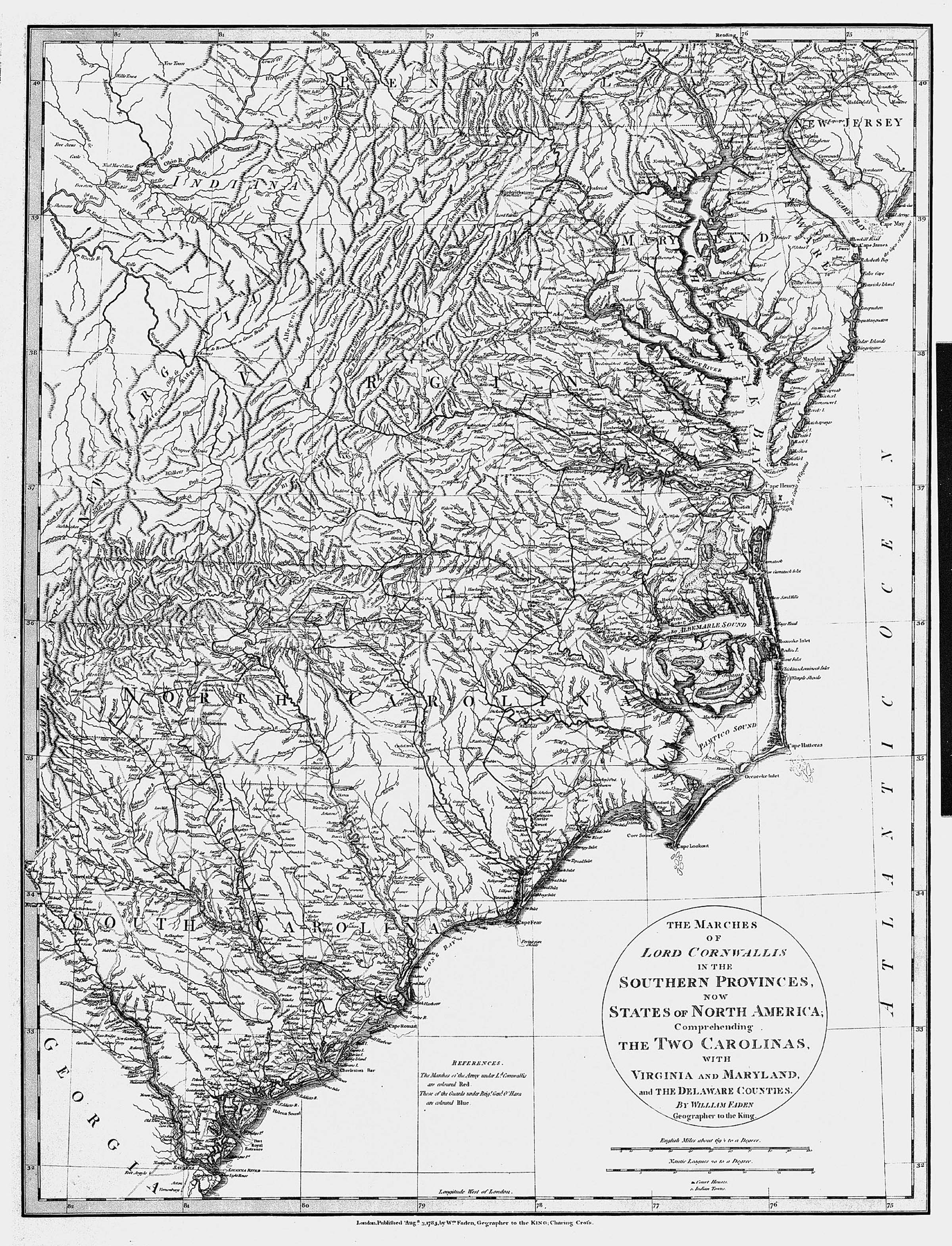
- The Marches of Lord Cornwallis in the Southern Provinces, now the States of North America Published August 3. 1785, by W.m Faden, Geographer to
the KING; Charing Cross. [2e, ob - 4e, ob]
643 x 490 Faden Separate publication, London 1785.; original in the University of Michigan Library, Ann Arbor. NC Office of Archives and History: T.84.6.11. London.
- The Marches of Lord Cornwallis and Major General Greene in the Southern Provinces, Now States of North America Comprehending the Two Carolinas probably by Faden. Included in David Schenck, North Carolina 1780-1781 Being a History of the Invasion of the Carolinas by the British Army under Lord Cornwallis in 1780-1781 (Raleigh: Edwards & Broughton, 1889).
- William Faden, Atlas of the Battles of the American Revolution, (London, 1845). See commentary on the 1845 republication.
LC Control Number:
74175034
Type of Material:
Cartographic Material
Personal Name:
Faden, William, 1750?-1836.
Main Title:
Atlas of the battles of the American Revolution, together with maps shewing the routes of the British and American Armies, plans of cities,
surveys of harbors, &c., taken during that eventful period by officers attached to the Royal Army.
Published/Created:
[New York, Bartlett & Welford, 1845?]
Description:
[2] l., 36 maps (part fold., part col.) 57 x 89 cm.
Subjects:
United States--History--Revolution, 1775-1783--Campaigns--Maps.
LC Classification:
G1201.S3 F2 1845
Dewey Class No.:
912/.1/97333
Geog. Area Code:
n-us---
CALL NUMBER:
G1201.S3 F2 1845
Copy 1
-- Request in:
Geography & Map Reading Room (Madison, LMB01)
-- Status:
Not Charged
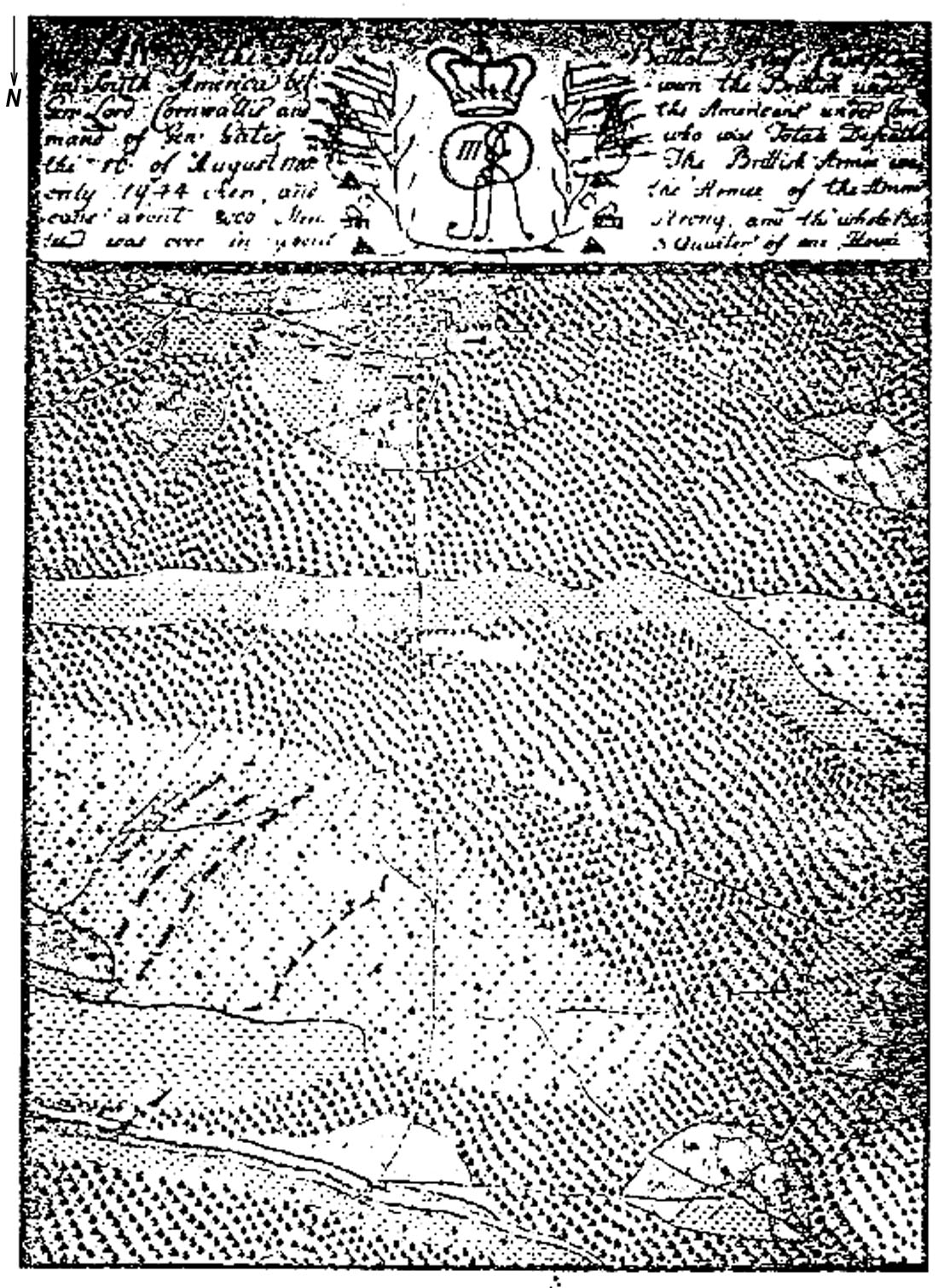
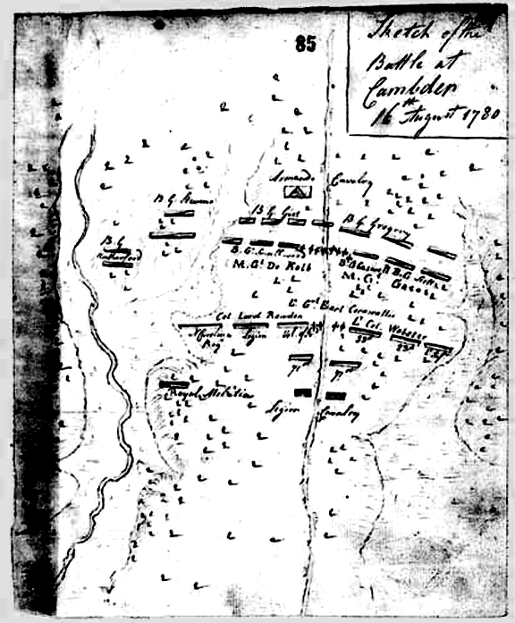
- FINNEGAN PLAN of the Field Battel close Campton in South America between the Brittish under Gen: Lord Cornwallis and the Americans under Command of Gen: Gates, who were Totale Defeathet the 16 of August 1780. The Brittish Armee was only 1944 Men,
and the Armee of the Americans about 8000 Men Strong and the whole Battel was over in about 3 Quarter of one Hour.. The original watercolor map by Lieutenant Finnegan of the 16th Regiment is in the North Carolina Collection, University of North Carolina at Chapel Hill.
See Paul David Nelson, "Horatio Gates in the Southern Department, 1780: Serious Errors and a Costly Defeat." North Carolina Historical Review, 50 (July 1973), pp. 256-272.
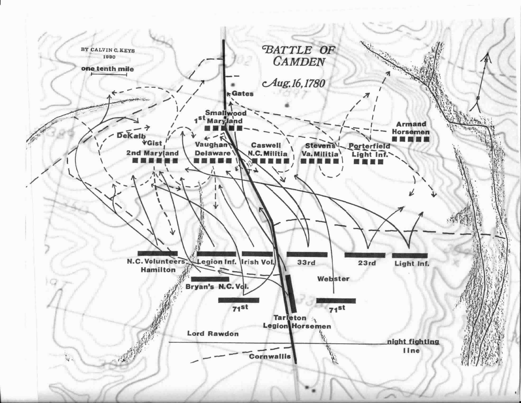
- KEYS: Submitted by Calvin Keys.
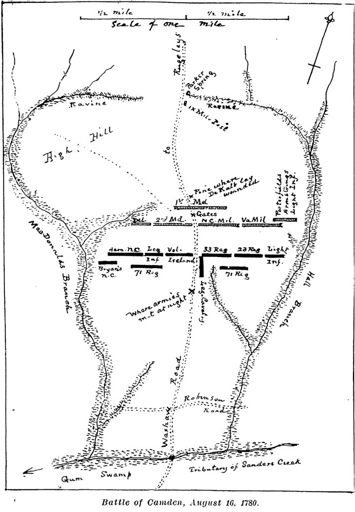
- KIRKLAND & KENNEDY: from Thomas Kirkland and Robert M. Kennedy
, Historic Camden, Colonial and Revolutionary, Vol. 1 (Columbia: The State Company, 1905; reprint Kershaw County Historical Society, 1994)
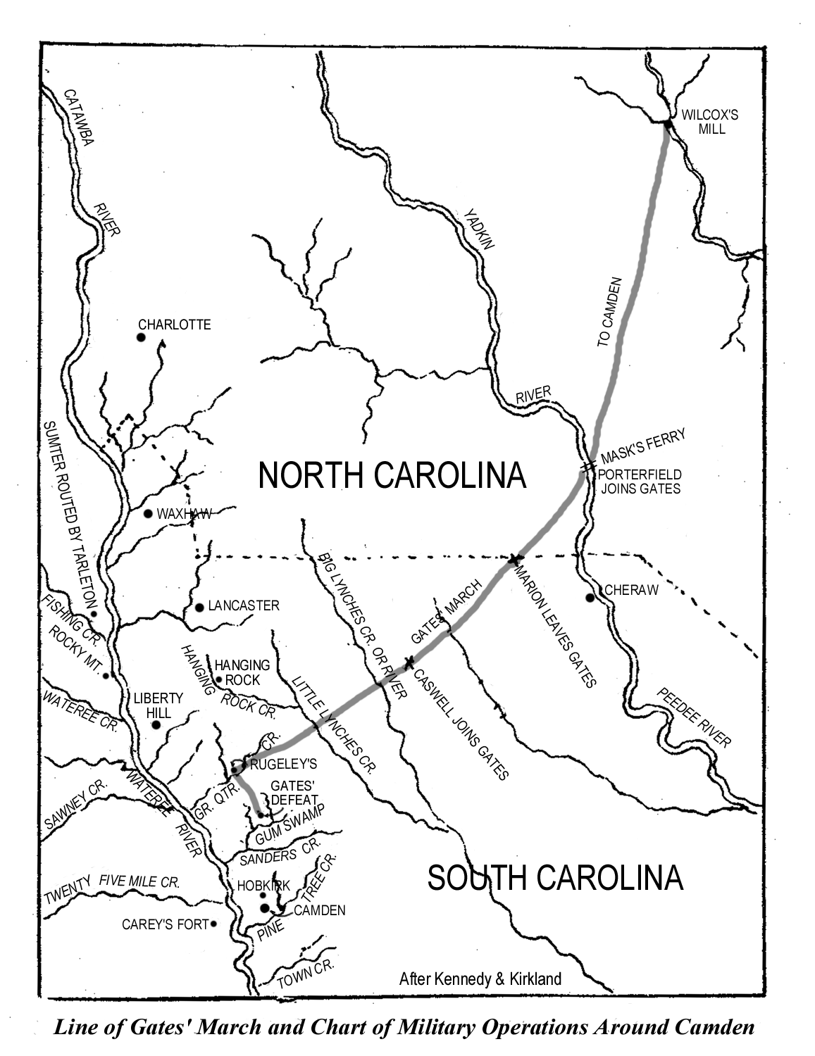
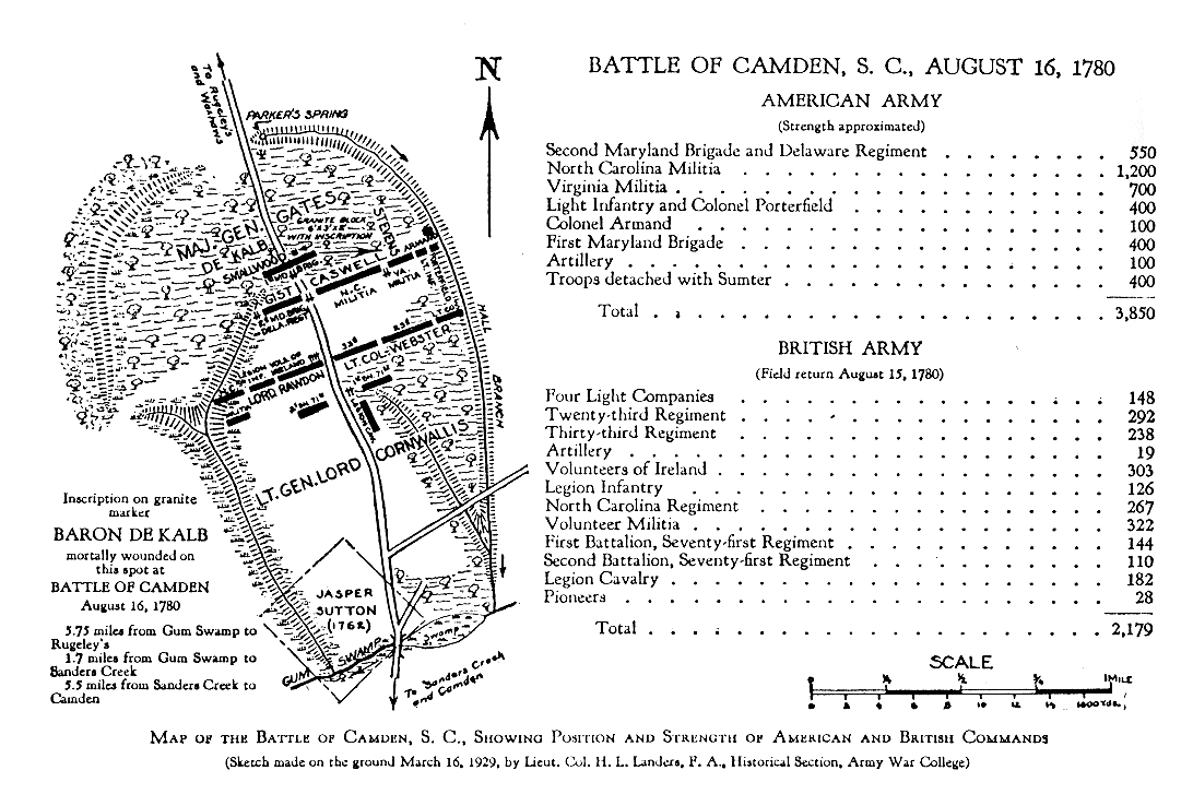
- LANDERS: Battle of Camden map from Lt. Col. H. L. Landers' book, H. L. Landers, The Battle of Camden, S.C., August 16, 1780 (Washington: U.S. Government Printing Office, 1929; Reprint, Kershaw County Historical Society, 1997). See Maps.
- LODGE:. A New and Accurate Map of North Carolina and Part of South Carolina with the Field of Battle between Earl Cornwallis and General Gates.. Appeared in Political Magazine, November, 1980, by John Lodge. Original is in the William L. Clements Library, University of Michigan, Ann Arbor. A copy is in the Archives, Office of Archives and History.
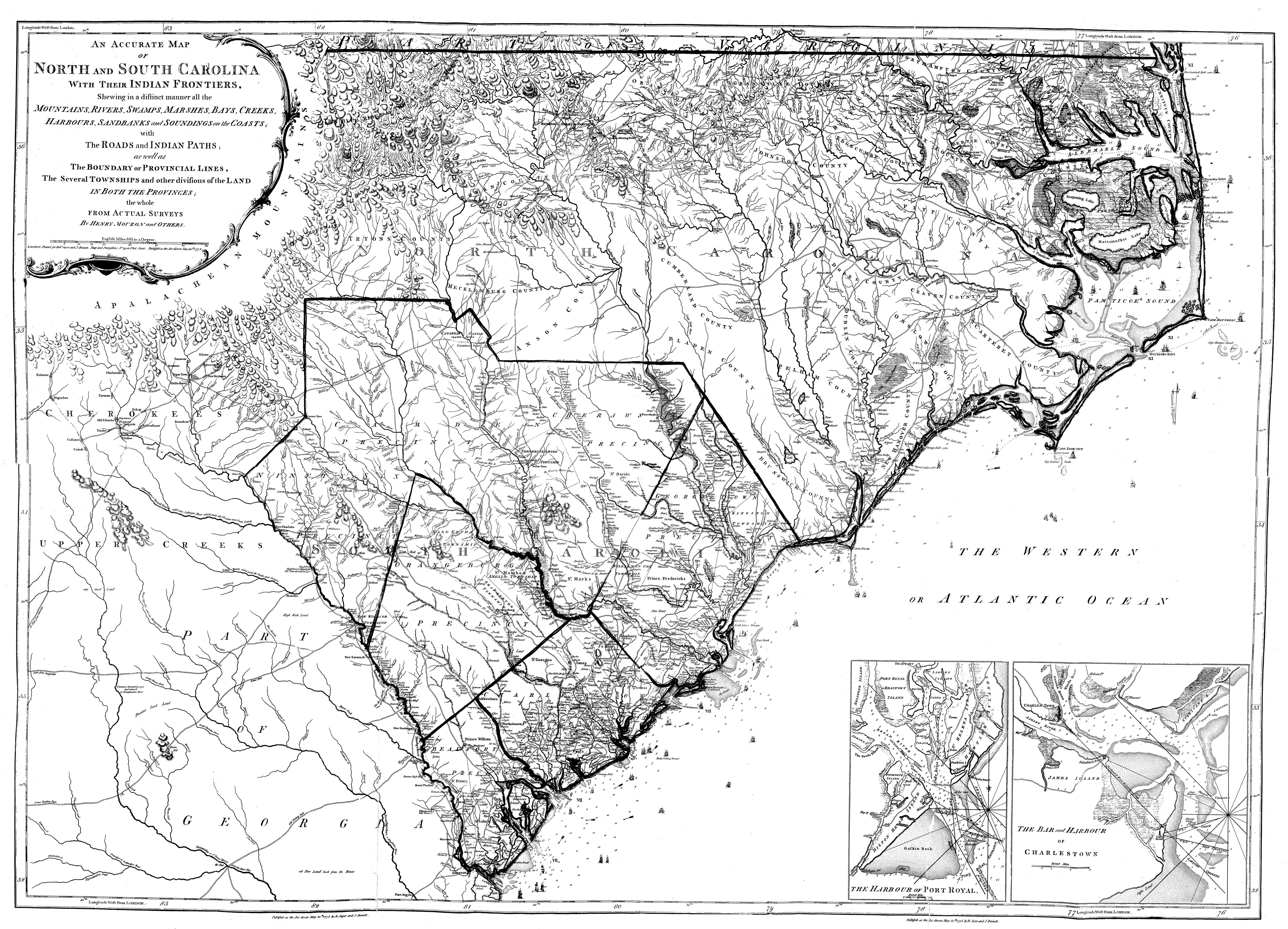
- MOUZON: An accurate map of North and South Carolina with their Indian frontiers, shewing in a distinct manner all the
mountains, rivers, swamps, marshes, bays, creeks,
harbours, sandbanks and soundings on the coasts; with
the roads and Indian paths; as well as the boundary or
provincial lines, the several townships and other
divisions of the land in both the provinces; the whole
from actual surveys by Henry Mouzon and others. Warning: 6 mb
LC Control Number: 74692527
Type of Material: Cartographic Material
Personal Name: Mouzon, Henry.
Main Title: An accurate map of North and South Carolina with their
Indian frontiers, shewing in a distinct manner all the
mountains, rivers, swamps, marshes, bays, creeks,
harbours, sandbanks and soundings on the coasts; with
the roads and Indian paths; as well as the boundary or
provincial lines, the several townships and other
divisions of the land in both the provinces; the whole
from actual surveys by Henry Mouzon and others.
Published/Created: [London] Printed for Robt. Sayer and J: Bennett, 1775.
Related Names: Robert Sayer and John Bennett (Firm)
Description: col. map 101 x 142 cm. on 2 sheets 54 x 144 cm.
Scale Information: Scale ca. 1:530,000.
Notes: Hand colored.
"Longitude west from London."
Relief shown by hachures. Depths shown by soundings.
Shows precinct boundaries.
Insets: The harbour of Port Royal [ca. 1:200,000]--The bar
and harbour of Charlestown [ca. 1:75,000]
Subjects: Harbors--South Carolina--Charleston--Maps--Early works to
1800.
Harbors--South Carolina--Beaufort--Maps--Early works to
1800.
North Carolina--Maps--Early works to 1800.
South Carolina--Maps--Early works to 1800.
North Carolina--Administrative and political divisions
Maps--Early works to 1800.
South Carolina--Administrative and political divisions
Maps--Early works to 1800.
Sea Islands--Maps--Early works to 1800.
Series: United States. Library of Congress. American maps. v. 5,
no. 25-26.
Variant Series: [American maps ; v. 5, no. 25-26]
LC Classification: G3900 1775 .M6 Am. 5-25
Geographic Class No.:
3900
3910
3901
3911
3914 C3 B4
3912 S4
CALL NUMBER: Am. 5-25 Vault
Copy 1
-- Request in: Geography & Map Reading Room (Madison, LMB01)
-- Status: Not Charged
- OLIVE BRANCH Sketch of the Battle at Camden, draftsman unknown, found in the British National Archives. Found on the Olive Branch site. See Maps.
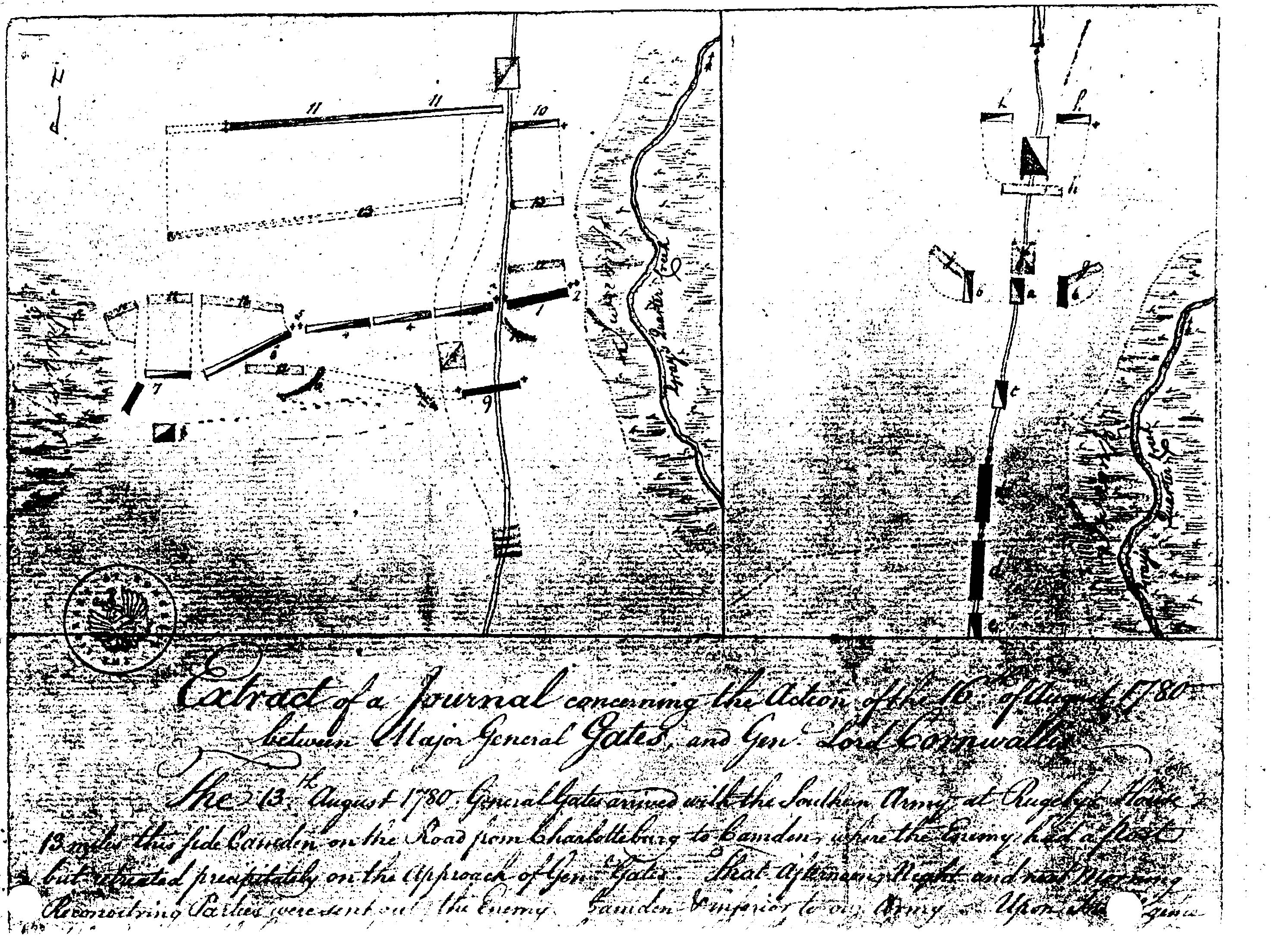
- SENF: Battle of Camden map drawn by Lt. Col. John Christian Senf. Part of: Johann Christian Senff, Journal extracts of Christian Senff, 1780 Manuscript Division, Library of Congress. LOC listing follows:
LC Control Number: mm 79004475;
Type of Material: Archival Manuscript Material;
Personal Name: Senff, Christian.;
Main Title: Journal extracts of Christian Senff, 1780.;
Description: 1 item.;
Biog./History Note: Continental Army officer.;
Summary: Extracts (1780 Aug. 16-19) from Senff's Revolutionary War journal relating to the battle of Camden, S.C.;
Notes: Transcript (handwritten). [S.l.];
MSS4475;
Forms part of: Miscellaneous Manuscripts collection.;
Source of Acquisition: Purchase, 1921.;
Subjects: United States. Continental Army.;
Camden, Battle of, Camden, S.C., 1780.;
South Carolina--History--Revolution, 1775-1783.;
United States--History--Revolution, 1775-1783--Campaigns.;
Army officer.; Local Call/Shelving: MMC; OVSZD 2:9;
Repository: Library of Congress Manuscript Division Washington, D.C.
- STEDMAN: Battle of Camden Map from Charles Stedman, The History of the Origins, Progress and Termination of the American War (London: J. Murray, Printer, 1794)
- TARLETON: Plan of the Battle Fought near Camden, August 16th, 1780 from Banastre Tarleton, A History of the Campaigns of 1780 and 1781 in the Southern Provinces of North America (reprinted in NY: Arno Press, 1968). Same as Faden, above. See Maps
- ACME MAPPER: Current aerial photograph of Battle of Camden site. Select "Satellite". For topo map, select "Topo". See Maps.
- :
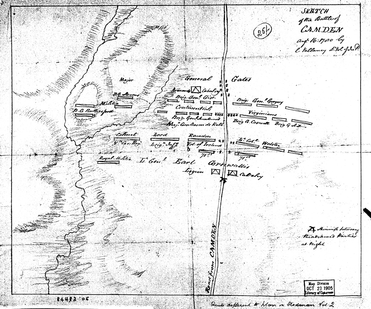
VALLANCY: Sketch of the battle of Camden, Augt. 16, 1780. Submitted by Sherri Bower.
LOC listing follows.
LC Control Number: gm 71000873; Type of Material: Manuscript Cartographic Material; Personal Name: Vallancey, Charles, 1721-1812; Main Title: Sketch of the battle of Camden, Augt. 16, 1780, y C. Vallancy; Published/Created: [1780]; Description: map 25 x 30 cm.; Scale Information: Scale not given.; Notes: Manuscript, pen-and-ink and pencil. On verso: Map of Camden fight, 1780. P.C. ...?; Subjects: Camden, Battle of, Camden, S.C., 1780--Maps, Manuscript, Early works to 1800.; LC Classification: G3914.C2S3 1780 .V3 Vault; Geographic Class No.: 3914 C2; CALL NUMBER: G3914.C2S3 1780 .V3 Vault; Copy 1; Request in: Geography & Map Reading Room (Madison, LMB01); Status: Not Charged. Commentary/Review
TOP
Online Map Sources
Source: CBB cd
TOP HOME
Links checked 4/17/2012 12:21:06 PM
|