 Old US 25E : Crossing the Cumberland Gap Old US 25E : Crossing the Cumberland Gap
A.K.A. - Looking for Virginia - Don't take photographs into the sun - A Gap high enough - Roadtripping without a car - Another great site of the Lost Highways Link Exchange. - Big Red Signs - Seed road planned to go to seed
 Following
this page are 33 images taken along the recently removed old
asphalt route of US 25E up and over Cumberland Gap. To see them
now and pass on a history lesson of the Gap, click here.
Following
this page are 33 images taken along the recently removed old
asphalt route of US 25E up and over Cumberland Gap. To see them
now and pass on a history lesson of the Gap, click here.
The Cumberland Gap has been in use for foot traffic since before Europeans colonized America. The earliest records of American use of the gap occur in 1769, when Daniel Boone explored the area. In 1775 he blazed a trail known as "Boone's Path" or Boone's Road". By 1779, Daniel Boone's blazed trail would be a primary route used by settlers moving into Kentucky and Tennessee. By 1796 the name "Wilderness Road" had came into common usage.
During the War Between the States, the strategic gateway was first occupied by Confederate General Zollicoffer on Nov 13, 1861. He retreated when a superior force under Union General Morgan approached. General Morgan fortified the Gap but he, too, was forced to retreat when Confederate General Bragg brought a superior force to the Gap in 1862. In 1863, Union Generals Shekelford and DeCourcy approached the gap from North and South in superior numbers, forcing the surrender of Confederate General Frazier, 2000 men, 18 guns, and a large supply of amminitions. The Gap did not change hands agian. During the war, King Solomon's Cave / Cudjo's Cave was mined for saltpeter for gunpowder and used for shelter, adding "Soldier's Cave" to its monikers.
The railroads bypassed the difficult terrain of the Gap after the States War. The arrival of the automobile rekindled interest in the Gap as transportation corridor. The US government built a macadamized road connecting Middlesboro, KY to Cumberland Gap, TN in 1908, adding the names "Government Pike" and "Object Lesson" to the names used along the route. The new road passed by Soldier's Cave, which started to become an attraction. In 1916, Virginia, Kentucky and Tennessee built macadamized roads connecting with the Government Pike, and the Pike was added to the "Dixie Highway" system. The 1921 Automobile Blue Book mentions a monument along the route showing where Virginia, Kentucky, and Tennessee meet.
 In 1925, the
Gap was included in the planning of US highways, on US 411's
planned route from Bristol, VA to Corbin, KY. The Tennessee
approach was not included, as it had been in the Dixie Highway.
US 25 had been assigned to much of the Dixie Highway, and Jellico
was the initial benficiary of the US 25 routing. By 1926, US 25
was split with a eastern leg passing through Cumberland Gap. US
411 truncated in Virginia. US 411 was replaced by US 58 in 1934.
In 1925, the
Gap was included in the planning of US highways, on US 411's
planned route from Bristol, VA to Corbin, KY. The Tennessee
approach was not included, as it had been in the Dixie Highway.
US 25 had been assigned to much of the Dixie Highway, and Jellico
was the initial benficiary of the US 25 routing. By 1926, US 25
was split with a eastern leg passing through Cumberland Gap. US
411 truncated in Virginia. US 411 was replaced by US 58 in 1934.
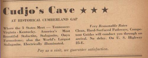
The name "Cudjo's Cave" came from a book with the same name by J. T. Trowbridge that was published in 1863. In it, a slave from East Tennessee named Cudjo escapes and hides in 'Cumberland Grotto' while making his way to Kentucky and the north. The description and locale of the grotto in the story were similar to the Cave. In 1920, Lincoln Memorial University bought the Gap, Cavern, and lots of surrounding land from private sources. The college leased the Cave to private interests who hoped to capitialize on the notoriety the Trowbridge book brought. The Cave was electrified in 1934. The advertisement is from 1940, with 'Very Reasonable Rates'. The stream in the cave supplied water and power for Lincoln Memorial University in Cumberland Gap, TN, in the valley below, and still provides water for LMU today. Cumberland Gap Mountain Spring Water is bottled from this source. The actual cave itself was leased by Lincoln Memorial University (LMU) to various operators over the years until it was donated to the National Park Service. Tours are once again held here, I have heard they plan to use lanterns in future tours as opposed to the old electric illumination.
In the 1990's, the Cumberland Gap Tunnel was built to replace the route over the gap. This allowed for four-laning of the highway, which would have been difficult up the historically sensensitive lands in Cumberland Gap National Park. The new tunnel was opened in 1996, and the old road was closed except for a short section still in use by the National Park Service.
In 1998, I climbed the gap and took 33 pictures, presented here for your enjoyment.
In 2002, the asphalt was removed from the old Wilderness Road in an attempt to restore it to the look of Daniel Boone's day. A picture of some of that restoration is here.
Cumberland Gap Links / Sources:
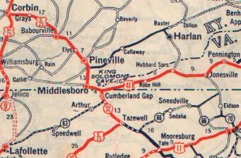
This University of Kentucky Map is pre-Tunnel, and shows the old alignment of US 25E
The Cumberland Gap National Park has a website, too, with Park maps, and a history of Cudjo Cavern
FHWA's website on the Cumberland Gap Tunnel Project
Dave Schul's North American Auto Trails - Dixie Highway, Boone Way
Private Calvin Unthank used Cudjo's cave during the States War
Acknowledgements / Sources :
Automobile Blue Book Vol. 6 - 1921
Rand McNally Road Atlas - 1928
AAA Southeastern Tour Book - 1940
Michael Vaughn, native
of Middlesboro, KY
Dave Butler, trucker who often traveled the Gap
Kim Beckner, former
student at LMU
Bill Porter, LMU
"The Wilderness Road" by Robert Kincaid - 1947
![]() U.S.
Highways : From US 1 to (US 830)
U.S.
Highways : From US 1 to (US 830)
![]() E-mail the creator of this
site, Robert V. Droz
E-mail the creator of this
site, Robert V. Droz
This page last updated Thursday, June 20, 2002