From North Platte To LaClede
Along the Overland Trail

PINE GROVE
The Pine Grove Station actually was located in a large grove of pine and aspen trees. After traveling ten dusty, desolate miles from the Sage Creek station, the shade and wind whistling through the trees was a welcome change. Pine Grove, a home station at the foot of Miller Hill, had a large building with a kitchen, dining room and sleeping quarters for women, as well as a separate bunkhouse for the men. There was also a barn and a blacksmith shop. Even though the station was rebuilt after Indian attacks in June of 1865, there are no remains.
Soldiers built an underground bunker, complete with rifle ports just above the ground level. After the attack in 1865, some Overland Stage staff fought their way through a Sioux war party on the way to Sulphur Springs. A dog on the station grounds barked and alerted the station master to the trouble. The Indians killed the dog with arrows and stuck the carcass onto the station walls with a pitchfork. A yellow pipe marks the site of the Pine Grove Station, and it is also on the National Register of Historic Places.
BRIDGER'S PASS The Bridger Pass Station was located just to the west of Bridger Pass, which may have been discovered as early as 1824 by Jim Bridger. Native Americans had hunted in the lush valleys on both sides of the pass for many years prior to this time. In May of 1865, Indians raided the station and took many supplies. Sioux Indians burned the station, built of logs, in June 1867. The Sioux stole the station cat, decapitated it, and left the body in the middle of the road.
SULPHUR SPRINGS The most defensible station between the North Platte crossing and La Clede was considered to be the Sulphur Springs Station built of logs and situated near Muddy Creek. The nearby springs had a strong sulphur smell. A garrison of troops from the First Kansas Volunteers and the 11th Ohio Cavalry provided lookouts atop the knoll behind the station night and day. Between 1863 and 1865 the station was attacked several times, with the Indians stealing the station livestock. In the summer of 1865 the attacks were frequent on the Overland Trail between Denver and Salt Lake, and the stage and wagon traffic was seriously disrupted. Robert Spotswood, who became the Division Agent after Jack Slade was fired, hauled the mail from Sulphur Springs to Fort Halleck in June 1865 using an army wagon. Spotswood then decided to hold the mail at both the Virginia Dale and Sulphur Springs stations, letting it accumulate for about 7 days. Passenger travel during this time was extremely light because of the attacks. With an army escort from Fort Collins, the stages would leave both stations, traveling only at night, and hiding during the day on some high ground so that they could watch for attacking Indians. Meeting in the middle, the mail and the few frightened passengers would switch coaches. Many of the stations were abandoned during this time and the stage employees would congregate at both Virginia Dale and Sulphur Springs for these expeditions.
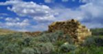
WASHAKIE The Rock ruins of the Washakie Station are still visible eight or so miles west of the Sulphur Springs Station in the area known as "Bitter Creek Country." The stationmwaster rigged up a fake cannon using a stovepipe with a big "US" pointed on each side. Supposedly this was to ward off Indian attack. Two companies of the 11th Kansas cavalry were headquartered here to protect the trail to Fort Bridger. Between fice and fifteen soldiers each were assigned to stations at Duck Lake, Dug Springs, La Clede, Big Pond, Black Buttes, Rock Point, Salt Wells, and Rock Springs. During this time the stages only ran 3 times a week.
One bullwacker, cossing this area many times during the 1860's wrote of his experiences in Bitter Creek Country saying that it was 'the horror of overland teamsters, where all possible ill of western travel are united." All the drivers of the Overland Stage line along this route spoke of it in anything but pleasant terms. For sixty miles on Bitter Creek, the soil "is a mass of clay or sand and alkali--a horrible and irreclaimable desert!" At an average elevation of over 7000 feet, "the tropic heat of the day was succeeded by the arctic cold after sundown with amazing suddenness."
Thirteen miles to the west of the Washakie station is the site of the Duck Lake Station. Nothing remains. About 4 miles farther west at the entrance to Barrel Draw is Red Rock. Emigrants' names are carved into the rock.
Some of this information is from the "Rocky Moutain News" June 1865
DUCK LAKE Nothing remains of this station.
DUG SPRINGS The Dug Springs Stations was considered by some to be the most impressive of all the Bitter Creek stations. A pit was dug below the spring and a barrel was sunk into the ground to catch the water. A rock ruin remains at Middle Barrel Springs Canyon.
FORT LA CLEDE and
LA CLEDE STAGE STATION:
Click on photo.
Send comments, suggestions or inquiries:
[Overland Trail |
Stations and Stops |
Links |
Virginia Dale]
Created and maintained by Elizabeth Larson
SAGE CREEK
Leaving the lush banks of the North Platte, the wagon trains and stages reentered the desolate sage brush country once again, traveling about 14 miles until they reached the Sage Creek Station. Located on Miller Creek, in a broad valley about 2 miles upstream from Sage Creek, the pine and aspen log station was quite large, about 25 by 60 feet, with an adobe fireplace and sod roof. At an elevation of around 7500 feet, the views in all directions were quite good. Unfortunately, this also meant that the Indians could see stages and wagon trains coming and going. After an excavation of the station site, it was suggested that the Sage Creek station may have been burned and rebuilt as many as five times. Trail ruts are visible along the Sage Creek Road.

 Overland Trail
Copyright © 1996-2001 All Rights Reserved