The Overland Trail
Big Pond to Fort Bridger

The Big Pond station saw its share of Indian problems, with five soldiers sent there in June 1865 from Company B, First Battalion, Nevada cavalry from their headquarters at the Washakie Station to protect the station inhabitants and livestock. On July 20, 1867, a group of 150 Indians descended upon the Big Pond station and burned it, but it was rebuilt.
It was near this station that emigrants discovered that coal found in this area was able to be burned in their camp fires. Today the land that the Black Butte ruins are found upon is owned by the Black Butte Coal Company, an open pit mining operation. They have erected a fence around the ruins, and will conduct a guided tour.
POINT OF ROCKS
Fourteen miles to the west of Black Butte is the Point of Rocks swing station. Located in the Bitter Creek Valley at the base of some spectacular sandstone outcroppings, this station was constructed from sandstone. This station, and those to the west, were supposedly built by Moses Byrne, under the direction of Ben Holladay. Buildings were located on both sides of the Overland Trail on Bitter Creek. There were also springs nearby that had cold, pure water.
It is reported that in 1863, Jack Slade, the now ex-division superintendent of the Overland Stage, robbed the stage near Point of Rocks. Slade killed seven passengers who then started the cemetary. Butch Cassidy also hid out in this vicinity after robbing a train.
When the Union Pacific Railroad reached this area in 1868, the Point of Rocks station became an important juncture point for freighting companies going to the South Pass gold mines. It was this freighting business that caused Point of Rocks to remain a viable town for many years. Today it is still a charming little town. There is an emigrant campground to teh east of Point of Rocks, and names carved into the sandstone bluffs near the springs can still be seen. The State of Wyoming owns the station ruins, and it is on the National Register of Historic Places.
SALT WELLS
The Salt Wells swing station, located about 14 miles to the west, is also on the banks of Bitter Creek. The creek water here was also not drinkable, and three hand-dug wells supplied water for the station. Emigrants were given the opportunity to purchase water from the station master. When they discovered that the creek water was so salty, they were forced to pay for this only available water.
ROCK SPRINGS
Rock Springs station was construction of sandstone at an excellent spring of fresh water, just below a high bluff. This was a sizable station, about 60 feet by 25 feet, with ports for rifles every twelve feet. In half of the building were stalls for livestock and a granery.
A marker can be located in the city of Rock Springs near where Springs Drive passes under the I-80 underpass. Rock Spings today is a bustling town dependent upon the coal industry.
GREEN RIVER
The Green River home station, headquarters for the Overland's Green River Division, was located on the Green River about 15 miles upsteam where the Bitter Creek flowed into the Green River. There was no bridge over the river until 1896. Until then, the stage coaches had to ford the river, or use the toll ferry. When the water was low, it was an easy crossing over a gravel river bed. During the spring time, wagons had to pay as much as $20.00 to cross the river on the ferry.
The Overland Trail at this point was heavily traveled, with folks traveling to and from both Utah and California to the gold areas around South Pass. Emigrants also crossed the Green River here to take the Oregon Trail to the northeast.
LONE TREE
The Lone Tree swing station was located about 14 miles west of Green River on the north side of Blacks Fork. It was named for a large nearby pine tree. There is no evidence of ruins of the station in the area.
HAM'S FORK
The Ham's Fork home station was also called Granger or South Bend. This station was probably in existance as early as 1856, and used by mail contractors going to Utah. This station was 18 miles to the west of Lone Tree at the confluence of the Blacks Fork and Ham's Fork rivers.
There is some controversy about this station with regards to the building and also the changes in names. The building that has been restored by the National Park Service may have replaced an earlier structure by Ben Holladay in 1862. He may have also changed the name then from Ham's Fork to Granger. The noted western photographer William Henry Jackson worked for a few months as a teamster for Holladay and spent three weeks at the station in 1866.
Some historians feel that the name "Granger" did not appear until 1868 when the first post-master arrived, named Lafayette Granger. It is to the west of this area that the Oregon Trail and the Overland Trail join.
FORT BRIDGER: built in 1844 by the famed Mountain Man, Jim Bridger as a trading post on the Oregon Trail.
Send comments, suggestions or inquiries:
[Overland Trail |
Stations and Stops |
Links ]
Created and maintained by Elizabeth Larson
BIG POND
The Big Pond swing station was located on Bitter Creek about 12 miles to the west of the La Clede station. Some remains of the station can be seen to the east of Bitter Creek Road next to the dry lake. . The station was constructed of flat slabs of fossilized snail shell sandstone that is prevalent in the near-by hills. It appears that the station buildings themselves were spead out a bit, with one building, erected over a hand-dug, rock-lined well, having a fireplace. There was also a corral.
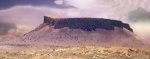 BLACK BUTTE
The Black Butte station, fourteen miles to the west of Big Pond, was named for a large black colored butte about five miles to the west of the station. This swing station was also located along Bitter Creek. At this point along the creek, the water was so tainted with alkali that oatmeal was added by the station cook to hide the taste.
BLACK BUTTE
The Black Butte station, fourteen miles to the west of Big Pond, was named for a large black colored butte about five miles to the west of the station. This swing station was also located along Bitter Creek. At this point along the creek, the water was so tainted with alkali that oatmeal was added by the station cook to hide the taste.

 Overland Trail
Copyright © 1996-2001 All Rights Reserved