(1861 - 1862), Doncaster
A Federal two-gun battery set up to counter the Confederate batteries across the river at Quantico Creek (Shipping Point), Virginia.
Battery Alexander |
Anderson's Fort |
Baker's Fort |
Battery Benson |
Bladensburg Defenses |
Budd's Ferry Battery
Conococheague Depot |
Cresap's Fort (1) |
Fort Cresap (2) |
Fort Cross |
Fort Cumberland |
Redoubt Davis
Battery Doubleday |
Fort Duncan |
Fort Foote |
Fort Frederick |
Hager's Fort |
Hessian Barracks |
Indian Head Battery
Jacques' Fort |
Killough's Fort |
Fort Kirby |
Battery Lane |
Fort Lincoln (2) |
Fort Mansfield |
Mills' Fort
Monocacy Blockhouses |
Fort Mount Pleasant |
Fort Nicholas |
Fort Pendleton |
Prather's Fort |
Shelby's Fort (1)
Shelby's Post (2) |
Shelby's Post (3) |
Fort Simmons |
Stoddert's Fort |
Stone Fort |
Fort Sumner
Tonoloway Fort |
Fort Warburton |
Fort Washington |
Fort at Wills Creek
Eastern Maryland - page 1
Budd's Ferry Battery
(1861 - 1862), Doncaster
A Federal two-gun battery set up to counter the Confederate batteries across the river at Quantico Creek (Shipping Point), Virginia.
Indian Head Battery
(1814), Indian Head
A US Naval battery with 18 guns set up to harrass the British fleet as they were sailing back downriver after attacking Alexandria, Virginia. Only one heavy gun was emplaced that did any real damage.
�� COAST DEFENSES of the POTOMAC RIVER (partial) (see also Fort Hunt, VA)
View DC Map
�� Fort Washington
(National Park)
(1824 - 1946, intermittent), Fort Washington

Fort Warburton, designed by Pierre L'Enfant, was built in 1809 but it was destroyed in 1814 to prevent the British from capturing it. A blockhouse with two guns, surrounded by an earthwork with five guns, was located where the later fort would be built. A five-gun Water Battery (1809 - 14) was located by the lighthouse. A Martello Tower may have been built in 1815, according to an old map. During the Civil War, the North Battery was built where Battery Decatur would later be built. The South Battery was located where Battery Many would later be. Endicott batteries include Battery Meigs (1900 - 1913), Battery Wilkin (1902 - 1928), Battery Smith (1903 - 1920), Battery Humphreys (1899 - 1929), Experimental Battery (1899 - 1900) buried, Battery Emory (1898 - 1929), Battery Decatur (1899 - 1918), Battery Many (1905 - 1928), and Battery White (1898 - 1920). An unnamed battery (1898) is located adjacent to Battery Humphreys (the gun from the experimental battery was moved here for wartime use). Battery White was built over top of the Ravelin Battery (1815 - 1830 / 1870's - 1898). Four 15-inch Rodmans were emplaced here in the 1870's. A Mine Storeroom is by the river. Mines were planted in the river in 1898. There are several fire-control towers still remaining here. This was the headquarters of the Potomac River Defenses. Admission fee.
A lighthouse was here from 1870 to 1901. Since 1901, the lighthouse's bell tower has been used as the lighthouse.
Fort Foote
(Park)
(1863 - 1878), near Oxon Hill
Originally a Civil War six-gun coastal defense to augment Fort Washington. North Battery was located on Roziers Bluff, now a picnic area just north of the fort. The magazines were rebuilt with early concrete in the 1870's. One was never completed, hence its ruined state today. The "King's Depressing Carriage" was tested here in the 1870's. The fort remained under military ownership until taken over by the National Park Service. Two original 15-inch Rodman guns are on restored carriages and mounts. One of the few examples left of an "1870's Plan", or "Fourth System" fortification.
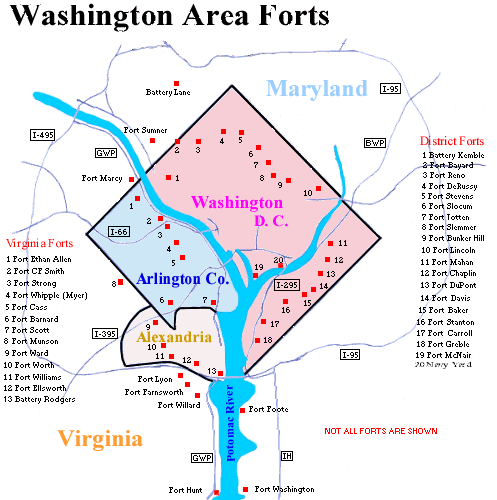
Civil
War Defenses of Washington D.C.
(1861 - 1865), near Chevy Chase
View DC map
Located in Maryland were Fort Simmons, Fort Mansfield, Fort Sumner,
and Battery Alexander. Other minor fortifications included Battery
Benson, Fort Cross (aka Redoubt Cross), Redoubt Davis,
and Fort Kirby (aka Redoubt Kirby). There was also Battery
Lane (park) in Bethesda, and the possibility of another fort in
Suitland. Of approximately 68 forts built around Washington during the
Civil War, these (plus Fort Foote) were the only ones in Maryland.
Most of these are located in various parks between Chevy Chase and the
Potomac River. Some have not been preserved.
� National
Archives MAP of Fort Sumner �.
Bladensburg Battlefield
(1814), Bladensburg
Earthworks and artillery breastworks were erected here by the federal army and local militia defending Washington, DC from the attacking British army. The Americans were routed, and the British advanced to burn and pillage the national capital.
Monocacy Blockhouses
(Monocacy National Battlefield Park)
(1862 - 1865), Frederick
Two stone blockhouses on either side of the Monocacy River protecting the railroad bridge.
Hessian Barracks 
(1777 - 1783), Frederick
Hessian prisoners were kept here after their capture in Trenton, NJ, and Saratoga, NY (via Albemarle Barracks, Charlottesville, VA in 1780). It was used as a hospital after the Battle of Antietam. It is currently located on the grounds of the Maryland School for the Deaf. Open by appointment only.
Stone Fort
(Harpers
Ferry National Historical Park - Maryland Heights)
(1863), near Harpers Ferry, WV
A Union fort located in the Maryland Heights section of Harpers Ferry
NHP. It later became a storehouse and commissary. Also located here are Interior Fort, Exterior Fort, Naval Battery, and several other minor batteries, one of which dates to 1862.
Fort Duncan
(1862 - 1865), near Harpers Ferry, WV
Located near the Maryland Heights section of Harpers Ferry NHP. It is located behind Lock #36 of the C&O Canal Historical Trail at mile 62. It was one of the defenses for Harpers Ferry.
Hager's Fort

(Hager House and Museum)
(1739 - 1760's), Hagerstown
The house was built over two springs to ensure a protected water supply. The city was founded in 1762 originally as Elizabeth Town, after Hager's wife. Located in Hagerstown City Park. Admission fee.
Conococheague Supply Depot
(1755 - 1760's), Williamsport
A stockaded supply base for the MD and VA Colonial Militias, and British regulars.
Battery Doubleday
(1862 - 1865), Williamsport
A Union earthwork battery built to halt Confederate raids across the Potomac River. Remnants still exist.
Fort Cresap (2)
(1750's - unknown), Williamsport
A stone house with a spring in its cellar, located north of Williamsport on Conococheague Creek. It was attacked in 1756.
Baker's Fort
(1755 - 1760's), Fairview
A settlers' fort on Baker's Ridge, 11 miles northeast of Fort Frederick. It was used by the MD Colonial Militia after 1756.
Prather's Fort
(1756 - 1759), near Big Spring
A settler's home used as a military depot. Located on Prather's Neck at Four Locks on the C&O Canal Historical Trail on mile 109.
Jacques' Fort
(1750's), Big Pool
A log house just east of Fort Frederick, four miles west of Prather's Fort.
Shelby's Post (2)
(1763 - 1773), Big Pool
A trading post established adjacent to Fort Frederick after Shelby's Fort (1) burned down (see below).
Fort Frederick
(State Park)
(1756 - 1764, 1780- 1783, 1861 - 1865), Big Pool
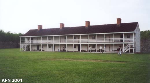
Located near the Potomac River. The stone walls were restored in 1934. The square-shaped stone fortress features four corner bastions and 17-feet high walls, with two wooden barracks that were restored in 1975. The Officers' quarters will be restored by 2006. During the American Revolution, the fort served as a POW camp for British and Hessian soldiers. The fort was sold by the state in 1791. The ruins of the fort were regarrisoned for the Civil War. The only action to ever occur here took place in December, 1861, by CSA raiders. PHOTO 1 | PHOTO 2
Shelby's Fort (1)
(1755 - 1763), near Clear Spring
A log house that was stockaded in 1755, and burned down in 1763. It was located three miles south of the Mason-Dixon line, on Mount Peiler, about five miles west of Baker's Fort.
Killough's Fort
(1754 - 1760's), near Indian Springs
A stockaded settler's home, located four miles south of the Mason-Dixon line.
Mills' Fort
(1754 - 1760's), near Millstone
Located southeast of Millstone, one mile from the Potomac River, five miles from Fort Frederick, along Licking Creek. A settlers' fort used by the MD Colonial Militia after 1756.
Tonoloway Fort
(1755 - 1756), Hancock
A MD Colonial Militia fort built for protection of settlers from Indians. It was also known as Stoddert's Fort. It was probably located on the east bank of Little Tonoloway Creek. It was attacked several times. It was abandoned after Fort Frederick was built.
Cresap's Fort (1)
(1742 - 1763), Oldtown
Also known as Fort at Cresaps. Located on the Potomac River, it was
originally a trading post that was stockaded in 1755. It was a supply base for several expeditions, and it was attacked several times. Only the ruins of a stone chimney remain.
Anderson's Fort
(1755), North Branch
A settlers' fort.
Fort Cumberland
(ruins)
(1749 - 1765), Cumberland
Located on the Potomac River. Once a star-shaped fort with four bastions, alongside a large stockade surrounding the garrison area. Its early names included Fort at Wills Creek, Post at Wills Creek, and Fort Mount Pleasant, and it was originally built by the Virginia Colonial Militia. Beginning in 1755 it was rebuilt by the Maryland Colonial Militia and was renamed. When George Washington surrendered to the British at Fort Necessity, PA in 1754, he retreated to this fort. The old fort was used in 1794 as a staging area for federal troops during the Whiskey Rebellion.
Fort Cumberland Trail is a walking tour highlighting parts of the fort's ruins. George Washington's Office, a log cabin, still exists. Part of the palisade has been reconstructed.
Fort Nicholas
(1755 - unknown), Cresaptown
A settlers' stockade with four blockhouses. It was attacked in 1756.
Fort Pendleton
(unknown dates), near Gorman
On the Potomac River southwest of Gorman.
Shelby's Post (3)
(1773 - 1775), Selbysport
A trading post on Buffalo Run.
NEED MORE INFO: Blockhouse Point Park in Montgomery County; Fort Lincoln (2) Cemetery in Bladensburg.
Towns:
Information on French & Indian War forts of the Potomac River basin gathered from "Frontier Forts along the Potomac and its Tributaries", by William H. Ansel, Fort Pearsall Press, 1984.
 Books about Forts in Maryland