Images
2.5 MB image of the map courtesy Brookhaven National Laboratory and Yale UP. For what it's worth, I think it's a duotone, not a color image.
Formerly the largest image (though still unsatisfactory) from "New fight over old map: Debate over oldest map of America flares again" by John Whitfield for Nature August 1, 2002. This is an excellent basic overview.
Vinland Map and close-up of Vinland courtesy "Cartographic Images". An enormous database of high-quality images of maps, ancient to modern.
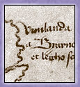
Translation of the text above "Vinland" and some rather low-quality redrawn images.
Web Archive: The Vinland Map, Close-ups. Formerly the best maps on the internet.
Sigurd Stefansson's map, with Vinland (1500s) from "The Norse in the North Atlantic" from the Memorial University of Newfoundland's attractive Newfoundland and Labrador Heritage website.

All material © 2000-2004 Tim Spalding.
Presented in Association with Amazon.
If you enjoy this site you may also like these other sites by me:
Alexander the Great on the Web. Links to over 1000 images and 200 images of Alexander.
The Complete Petra. Comprehensive guide to Petra, the "lost" city of Jordan.
Sir Richard F. Burton on the Web. Guide to the explorer and translator of the Arabian Nights and the Kama Sutra.
Machu Picchu on the Web. The scoop on the great "lost" city of the Andes.