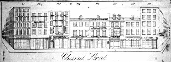
Rae's Philadelphia Pictorial Directory and Panoramic Advertiser, published as a wide folio volume in 1851, depicted buildings on both sides of Chestnut Street between Second and Tenth streets in sxiteen lithographed plates. Both sides of the street were shown on each plate, each covering about half a block; the south side was shown at top, the north side, inverted, was below.
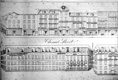
In his preface Rae spelled out some of his intentions, recalling that he had "some time since conceived of the idea of a new system of advertising," one which he believed was unique and original. It would "give the FORM AND FEATURE, as it were, of each place of business within certain limits." Rae interleaved the panorama plates with typeset sheets laid out with approximations of business cards for those who paid for these, giving this publication advertising value. In addition, he would add names on otherwise blank signboards for those who purchased volumes. This must explain the typeset names pasted on certain plates on some copies of the volume (e.g. the blacking symbol atop #50 Chestnut on pl. 1, "Milnor & Shaw" on #110 on pl. 4, "Adams & Co. 's Express" on #116 on pl. 5).
This image is Rae's view of the eastern half of the south side of Chestnut (or "Chesnut") Street's 300 block. Note that the modern numbering system, coordinated by hundreds with cross streets, had not yet been adopted, leaving 300 Chestnut as number 96, at left. This plate from the Athenaeum of Philadelphia's copy has a pasted emendation at right, apparently to update the last shop's proprietorship.
Rae's preface noted that he intended "to issue the Panoramic View annually, giving all the alterations in the structures in the structures, and the changes in the business of Chesntut Street." He proposed to turn next to Market Street, from the Delaware to Broad Street, but apparently this did not reach fruition.
Rae's commercial motive was evident in his choice of blocks; as the plates show, they were almost entirely occupied by business, although many of the buildings had been built for domestic purposes and were more recently adapted to commercial life, mainly by opening shop windows into ground-story fronts. This urban landscape would very soon be transformed architecturally, as brownstone and marble fronts rising to elaborate cornices replaced brick fronts crowned by dormers, and many facades were given the guise of historic detail.
The result was a richly varied streetscape of contrasting styles, profiles, and colors. The rapid change was proudly documented in a new set of panoramas, "The Baxter Panoramic Business Directory," whose first dated plates appeared 1859 (although Baxter claimed he had established the project two years earlier, the date it was copyrighted in U.S. District Court). His coverage was less straightforward, as he chose blocks for their potential for advertising revenue. It therefore tracked scattered blocks in an expanding commerical district rather than a continuous streetfront, and thus included blocks on Market Street, Walnut Street, Third, and Fourth streets. In what must be one of his earliest plates, possibly from 1857, he spelled out some of his expectations, which also included Second and Front streets and what he called "the city front," but that he would move forward only with blocks for which he found eight "subscribers" at $25 each, for which they would receive one or more of the 16 business card spaces, in this case below the image of only one side of the block, their name on their edifice, and 100 free copies for them to distribute.
Baxter issued his plates not in a bound volume like Rae's, but independently, initially as large two-color woodcut sheets and later as lithographed broadsides in printings of 1000. Some blocks reappeared in revised editions incorporating changes in the block. Over the course of three years he published some twenty sheets covering some 16 different blocks, some with variant advertising copy below the image.
Baxter suspended his efforts on the eve of the Civil War. He claimed to have distributed no less than 5000 copies of each image in his first series, and 50,000 of several. As he explained when he renewed his effort in 1879 (on panorama number 1 of the second series, of the 900 block of Chestnut Street, from April of that year), it had been "interrupted in its publication owing ot the national disturbance of 1861-65, and since then for other causes." "It is now designed," he continued, "to carry out the original object of its projector, and compile into BOOK FORM, PERFECT VIEWS of all the prominent business blocks in the city." He had already selected 125 blocks to be recorded, he explained, forty-five of which had already "received the finishing touches of the artists employed on the work." At first, however, he planned to publish these as single sheets. Each block's "architectural peculiarities" and signs (of subscribers), would be represented, along with the business-card-like notices below the images, sometimes themselves illustrated with product images. The plates were to be distributed gratuitously, all the revenue to come from the "subscriptions or advertising." Although the project bore Baxter's name, the "Publishers & Proprietors" were identified as A. C. Weaver & Co., which specialized in "photo relief plate engraving." Weaver & Co. noted that "Copies of this Square may be procured gratuitously of any of the above subscribers, or at the office of publication." Not coincidentally, the publisher's place of business address, 916 Chestnut Street, was on the first block recorded in the second series, published in April 1879.

This shows Baxter's plate two, from May 1879, of the north side of the 600 block of Chestnut Street. This may have been one of his more successful offerings, for he almost immediately printed a second edition of this block. [research: differences?]
In June 1879, in the fifth number of the new series (of the opposite side of the 600 block of Chestnut Street), Baxter further discussed the transformation of this part of the city: