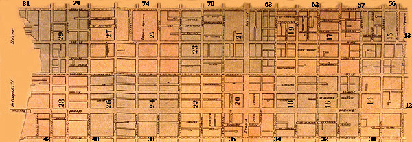
Select a plate from Index #2 of the Hexamer & Locher Atlas of Philadelphia
from 1857-1860. . .
[The boundaries of the plates are distinguished by color]

. . .Or, Link from this Text List Below.
[Note: All images of the 1857-1860 Hexamer & Locher Atlas on this
site were obtained from the Free Library of Philadelphia.]
- Plate 14 (including all blocks from Seventh Street
to Ninth Street, from Chestnut Street to Arch Street)
- Plate 15 (including all blocks from Seventh Street
to Ninth Street, from Arch Street to Vine Street)
- Plate 16 (including all blocks from Ninth Street
to Eleventh Street, from Chestnut Street to Arch Street)
- Plate 17 (including all blocks from Ninth Street
to Eleventh Street, from Arch Street to Vine Street)
- Plate 18 (including all blocks from Eleventh
Street to Thirteenth Street, from Chestnut Street to Arch Street)
- Plate 19 (including all blocks from Eleventh
Street to Thirteenth Street, from Arch Street to Vine Street)
- Plate 20 (including all blocks from Thirteenth
Street to Fifteenth Street, from Chestnut Street to Arch Street)
- Plate 21 (including all blocks from Thirteenth
Street to Fifteenth Street, from Arch Street to Vine Street)
- Plate 22 (including all blocks from Fifteenth
Street to Seventeenth Street, from Chestnut Street to Arch Street)
- Plate 23 (including all blocks from Fifteenth
Street to Seventeenth Street, from Arch Street to Vine Street)
- Plate 24 (including all blocks from Seventeenth
Street to Nineteenth Street, from Chestnut Street to Arch Street)
- Plate 25 (including all blocks from Seventeenth
Street to Nineteenth Street, from Arch Street to Vine Street, and Logan
Square)
- Plate 26 (including all blocks from Nineteenth
Street to Twenty-First Street, from Chestnut Street to Arch Street)
- Plate 27 (including all blocks from Nineteenth
Street to Twenty-First Street, from Arch Street to Vine Street)
- Plate 28 (including all blocks from Twenty-First
Street to the Schuylkill River, from Chestnut Street to Arch Street)
- Plate 29 (including all blocks from Twenty-First
Street to the Schuylkill River, from Arch Street to Vine Street)
[Note: If you would like to see the plate(s) for a block adjacent
to one shown on this index map, either click on the edge of index map nearest
the block you would like to see (on the black plate number), or choose a
plate from this list of adjacent blocks below]
- Index 1, Plate 12 (including all blocks
from Fifth Street to Seventh Street, from Chestnut Street to Arch Street)
- Index 1, Plate 13 (including all blocks
from Fifth Street to Seventh Street, from Arch Street to Vine Street, and
Franklin Square)
- Index 3, Plate 30 (including all blocks
from Seventh Street to Raspberry Street, from Spruce Street to Chestnut
Street)
- Index 3, Plate 32 (including all blocks
from Raspberry Street to Twelfth Street, from Spruce Street to Chestnut
Street)
- Index 3, Plate 34 (including all blocks
from Twelfth Street to Broad Street, from Spruce Street to Chestnut Street)
- Index 3, Plate 36 (including all blocks
from Broad Street to Seventeenth Street, from Spruce Street to Chestnut
Street)
- Index 3, Plate 38 (including all blocks
from Seventeenth Street to Twentieth Street, from Spruce Street to Chestnut
Street, and Rittenhouse Square)
- Index 3, Plate 40 (including all blocks
from Twentieth Street to Twenty-Second Street, from Spruce Street to Chestnut
Street)
- Index 3, Plate 41 (including all blocks
from Twenty-Second Street to the Schuylkill River, from Spruce Street to
Chestnut Street)
- Index 5, Plate 56 (including all blocks
from Sixth Street to Eighth Street, from Vine Street to Buttonwood Street)
- Index 5, Plate 57 (including all blocks
from Eighth Street to Tenth Street, from Vine Street to Buttonwood Street)
- Index 5, Plate 62 (including all blocks
from Tenth Street to Twelfth Street, from Vine Street to Spring Garden
Street)
- Index 5, Plate 63 (including all blocks
from Twelfth Street to Broad Street, from Vine Street to Spring Garden
Street)
- Index 6, Plate 70 (including all blocks
from Broad Street to Seventeenth Street, from Vine Street to Hamilton Street)
- Index 6, Plate 74 (including all blocks
from Seventeenth Street to Twentieth Street, from Vine Street to Hamilton
Street)
- Index 6, Plate 79 (including all blocks
from Twentieth Street to Twenty-Third Street, from Vine Street to Hamilton
Street)
- Index 6, Plate 81 (including all blocks
from Twenty-Third Street to the Schuylkill River, from Vine Street to Coates
Street)
Link to: [Hexamer
& Locher Atlas Intro Page] [Home]
url=hlatlas/2/hl2ind.html; last rev.: 21 aug. 2000 cc

