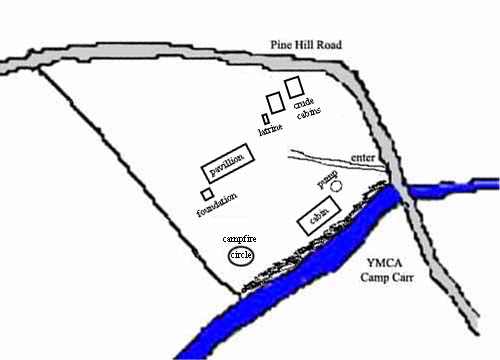
Map of Camp Buck
There is not much to see at the camp besides trees and brush. Enter the former camp by driving past Camp Carr, over the bridge and immediately look to the left. You will see a small parking area and a sign. Follow the path up the hill. The map shows the approximate location of past camp facilities. The most noticeable feature of the camp, the high bluffs along the river, are shown as a blackened area along the river. Only the pavilion is still standing, but is starting to deteriorate. Could be a great Eagle project to renovate the structure. Details of the map were provided by Charles T. Tart, from his memories of camping as a Scout during the 1950s. He does not remember the pavilion and I believe it was constructed after Charles was with the scouts. The cabin featured a nice fireplace (f) to the right, with the door (d) to the left. Rosemary and I have walked the camp grounds, but we were not able to locate any of the facilities, other than the pavilion. Hunterdon County Parks and Recreation acquired the Camp Buck property in 1974 as open space along the South Branch of the Raritan River. The park extends along the river front, on both sides of the former Camp Buck, with a small trail system available for public use. Hunterdon County YMCA Camp Carr is across the river from Camp Buck. Camp Buck, 11.39 Acres
|