The Somme Battlefields in One Day
While it is clearly impossible to ‘do’ the Somme battlefields in one day, I am aware that many casual or first time visitors to the area have limited time. While we are now well served these days with battlefield guidebooks and other source material, it is often difficult to know where to start on any battlefield and these pages will therefore offer some advice on what to prioritise if you really only have a day available to see the main sites on the Somme.
You will require one of the following maps:
Michelin Yellow series No 52
IGN Green Series No 4 ‘Laon-Arras’
The tour presumes you will take your lunch with you, and eat it somewhere along the way – there are few places to eat out on the battlefields themselves, and with only a day you will be wasting time.
As usual, email me with any questions.
![]()
The tour begins with the assumption that you will start in Albert, as you will either be based in or near the town accommodation wise, or if you are passing through or simply coming down for the day, then it is easy to find from the main A1 Paris motorway. For details of places to stay in the area, see the Battlefield pages elsewhere on the site.
BACKGROUND TO THE 1916 SOMME BATTLE
The Battle of the Somme began on Saturday 1st July 1916, following a week long bombardment of the German trenches during which 1¾ million shells were fired. On the first day alone fourteen British divisions attacked on a front from Gommecourt in the north, to Montauban in the south. In most sectors the attack was a disaster, and by the close of the days fighting the British had lost more than 57,000 casualties. This was largely attributed to:
|
Uncut wire in front of the German trenches. | |
|
The failure of the bombardment to smash key German positions. | |
|
The lack of heavy guns in the British sector, which contributed to the above. | |
|
The rigidity of the bombardment – infantry units were unable to call back friendly fire to assist them, as the timetable was set and could not be changed. |
This was the bloodiest day in British military history, and one that has prompted much debate among military historians, particularly regarding the leadership qualities of Douglas Haig, then commanding British forces in France.
However, despite these losses, in the sector between Mametz and Montauban the attacking divisions had captured all their objectives. The fighting continued into an area characterised by woodland, and Mametz Wood, High Wood and Delville Wood soon became household names. On the 15th September 1916 a new weapon appeared on the battlefield – the tank. It was used by the British army in the Battle of Flers-Courcelette, and although some historians have accused Haig of using them in "penny packets", this new weapon nevertheless changed the nature of warfare forever. The weather changed for the worse towards the end of the battle, and following several engagements on the Ancre Heights, the fighting concluded in a snow storm on 18th November 1916. Since the start of the battle, the British army had suffered an estimated 400,000 casualties – the Somme had truly become the graveyard of Kitchener’s Army. By the end of the campaign, almost every British division in France at the time, and every regiment in the British army, had fought there.
ALBERT
Albert was the main town on the Somme front, as far as the British were concerned. It acted as a staging post for units on the Somme, and it is likely that almost every British and Commonwealth soldier who fought in the 1916 battle passed through it at some stage. A railhead existed just outside the town at Dernancourt, there were Advanced Dressing Stations in an old factory and a familiar landmark was the church, or basilica. Only completed in 1912, Notre Dame de Breberies had a tall tower with a golden figure of Mary with her outstretched arms, holding the infant Jesus. In January 1915 the tower was struck by shell fire, one round hitting the statue itself. It thereafter hung at a roughly ninety-degree angle, and French Engineers wired it up to stop it falling into the square below. The legend grew that if the virgin fell, the war would end. When the British arrived on the Somme in the summer of 1915, it was christened the ‘Leaning Virgin’ or the ‘Golden Virgin’. Australian troops a year later christened it ‘Fanny Durack’ after a female Olympic swimmer who had won a gold medal before the war; they reckoned it looked like her diving into a swimming pool! Despite further bombardments, it did not fall until 1918 – when it was felled by British guns after the Germans captured Albert in March. The town wasn’t liberated until August, and by the close of the war was in ruins. Rebuilding started in the early 1920s, and the Basilica was restored to its former glory.
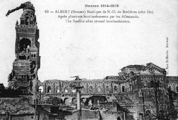
The Basilica in 1916
Today Albert is still very much a sleepy market town, and on Mondays very little is open. However, there are cafés and an Internet Café in Rue Jeanne d’Harcourt. Alongside the modern basilica, which is open daily and well worth a visit, is the Musee des Abris. This museum of the Battle of the Somme opened in the late 1980s, and is located below ground in a series of tunnels that were used as air raid shelters in the Second World War. On display is a vast array of material, from uniforms and equipment to photographs and maps. It is open daily from. The museum is normally closed at lunchtime, although in the summer months this is not always the case. There is a small shop where you can buy books and battlefield souvenirs. Credit cards are accepted.
Leave Albert by the D50 and go north, passing through Aveluy and the large Aveluy wood. En-route you will begin to notice green Commonwealth War Graves Commission (CWGC) signposts for military cemeteries; it is hardly possible to travel for more than a mile or so without seeing one, or the cemetery itself. In the next village, Hamel, turn left on the D73 and follow signs for the Newfoundland Park. The road rises uphill past the church, and out of the village. You will soon arrive at the park entrance, with a large parking area on your left – leave the vehicle here.
NEWFOUNDLAND PARK, BEAUMONT HAMEL
The Newfoundland Park commemorates the men of the Royal Newfoundland Regiment who fought here on 1st July 1916 when they lost 26 officers and 658 men in the attack on Beaumont-Hamel. After the war the ground was purchased by the mothers and widows of the men who had died here that day. A whole section of the Western Front is preserved here – with British trenches on one side, No Man’s Land, and the German lines on the opposite side of the park. Beyond the German lines is the huge Y-Ravine – an old prehistoric quarry the shape of a ‘Y’, used by the Germans in 1916 and once containing deep dugouts and many tunnels.
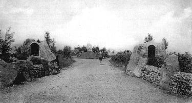
Newfoundland Park in the 1920s.
The bronze panels below the impressive Caribou Memorial commemorate the men of the Newfoundland Regiment who died at Gallipoli and on the Western Front who have no known grave. There are over 800 names. Within the confines of the park are three military cemeteries:
|
Y Ravine Cemetery |
366 graves |
|
Hunters Cemetery |
46 graves |
|
Hawthorn Ridge No 2 Cemetery |
214 graves |
Near the German lines is a fine bronze memorial to the 51st (Highland) Division who captured Beaumont-Hamel on 13th November 1916. A Gaelic inscription on the base of this memorial reads, "Friend are good on the day of battle." Close to the Y Ravine is another Highland Division memorial – a wooden cross commemorating the unit’s participation in the fighting at High Wood in August 1916.
Given the size of the park, and what there is to see here, you will require at least an hour here – more like an hour and a half. There is a new visitors centre (opened July 2001) close to the main entrance, where there are on-site guides who will take you round the park for free. Otherwise, you can pick up a free leaflet and follow a trail.
Leaving the car park, continue on the D73 and pass through Auchonvillers (‘Ocean Villas’ to the troops!). In the village turn right at the cross-roads by the church, and onto the D163 towards Beaumont Hamel. After about a mile from the cross-roads, you will see a green CWGC signpost for Beaumont Hamel. Turn left here and follow the minor road to the start of a sunken lane with a large memorial cross in it.
SUNKEN LANE, BEAUMONT HAMEL
There are many sunken lanes on the Somme, but this is the most famous. Located in No Man’s Land, the British annexed it just prior to 1st July and 252nd Tunnelling Company Royal Engineers constructed a tunnel linking it with the old British front line. In the early hours of 1st July 1916 the 1st Battalion Lancashire Fusiliers came up into the sunken lane to use it as a jumping off position for the attack on Beaumont Hamel. They were a famous regular army battalion, commanded by Lieutenant Colonel Meredith Magniac, who had won ‘Six VCs Before Breakfast’ at Gallipoli in April 1915 (See Lancashire Landing page). As the 1st Lancashire Fusiliers left the cover of the sunken lane on 1st July they came under terrific machine-gun fire from Beaumont Hamel and Hawthorn Ridge. Magniac was wounded, and later awarded a Distinguished Service Order for his bravery that day – only to be killed at Arras the following year. His proud battalion lost 18 officers and 465 men in the fighting on 1st July.
After 1st July the Sunken Lane became the new British front line, and in the final attack on Beaumont Hamel on 13th November 1916, the 1/8th Argyll & Sutherland Highlanders attacked from here. Their battalion memorial is now found at the entrance to the Sunken Lane.
Nearby is Beaumont Hamel British Cemetery. With 113 graves, the majority of the men buried here are soldiers who fell on 1st July, with some from 13th November.
Return to the D163 and turn left, following it into the village of Beaumont Hamel. Turn right at the cross-roads onto the D163E and stay on it to Beaucourt. Here go right, past Ancre British Cemetery, and turn left at the railway cross onto the D73 again. Follow the road uphill to a large tower set among trees on your left.
ULSTER TOWER, THIEPVAL
Two divisions were allocated to attack the ground surrounding Thiepval, with the 36th (Ulster) Division on the left flank. Here they would advance on The Pope’s Nose and Schwaben Redoubt and continue to Grandcourt. Despite some initial success, the division was thrown back with heavy losses. In the 1920s the Ulster Tower was erected in memory of all Ulster men who died in the First World War; it is a copy of St Helen’s Tower in Ireland, where the division did its training in 1914/15.
At the rear of the tower is a visitors centre where you can view various displays and objects connected with the fighting here. There is also a shop, where light snacks and drinks can be purchased, and also battlefield souvenirs and a small selection of books. It is normally closed on Sundays and Mondays.
Continue on the D73 into Thiepval village. Turn right at the cross-roads, and then first left following signs for the Thiepval Memorial. This access road takes you to the parking.
THIEPVAL MEMORIAL
Thiepval was one of the most heavily defended villages on the Somme battlefield. On a high point, the so-called Thiepval Ridge, deep German trenches encircled the village and huge chateau. To the south was the Leipzig Redoubt, and to the north-west the Schwaben Redoubt. Two units were allocated to attack the positions around Thiepval on 1st July – the 32nd and 36th (Ulster) Division. Despite early successes by the Ulster Division, both failed in their objectives: the men of the 32nd Division being mowed down as they climbed the ridge towards Thiepval. Losses were heavy: the 32nd had nearly 4,000 casualties and the Ulster Division over 6,000.
Despite further attacks Thiepval did not fall until 26th September 1916 when the 18th (Eastern) Division took what was left of the village, assisted by tanks and a powerful creeping barrage.
Full details of the memorial are on the Thiepval Memorial page.
Return to the centre of Thiepval and follow the D73 to Pozières. In the village, turn left on the D929 towards Bapaume. A few hundred yards further on stop in a lay-by on the right, close to two memorial sites.
TANK CORPS MEMORIAL
This memorial is the only one that commemorates the use of tanks by the British Army during the Great War. It is located at the start point for six Mk I tanks that were attached to the Canadian Corps in their attack on the village of Courcelette, which is across the fields to the north-east. This was the first use of tanks in warfare, and was part of the Battle of Flers-Courcelette on 15th September 1916. On this more than forty tanks were used, with mixed results. The first great achievement of the tanks was at Cambrai in November 1917, and in the final battles of the war in 1918. The memorial was erected in the 1920s, and is surrounded by four bronze models of WW1 tanks. One of them shows signs of damage from aerial strafing in 1944, and the fence around the memorial consists of driving chain and six-pounder guns.
Directly opposite is another memorial – take care to cross the road.
POZIERES WINDMILL
This is one of the highest points on the Somme battlefields, and on a clear day it is possible to see some considerable distance from here – for example, all the way to Gommecourt in the north. The Germans realised the importance of this position, which was a stone built windmill before 1914. They fortified it, and had a huge dugout underneath. East and West of the site they constructed two lines of trenches, known as OG1 and OG2 to the British. These were attacked by Australian troops in August-September 1916, and the memorial here specifically commemorates the 2nd (Australian) Division. It records that "Australians fell more thickly on this battlefield than any other of the war"; indeed, Australian casualties here and at Pozières were more than 20,000 – almost as many as they had lost at Gallipoli in 1915.
Stay on the D929 to the next junction, then turn right on the D6 following signs for Longueval. Pass through the village of Martinpuich, and continue on the D107 to a large wood. Stop at the CWGC cemetery on the right.
HIGH WOOD
One of the most fought over, and indeed infamous corners of the Somme battlefield, High Wood is located on some of the highest ground in this area – thus its name. There was almost two months of constant fighting, with the first attacks on 14th July 1916. During this operation the one and only cavalry charge enacted on the Somme took place. A mixed force of British and Indian cavalry units successfully charged the north-east corner of the wood, with few casualties. However, the Somme was not a place for cavalry, and the rest of the fighting was a hard infantry battle in which flame-throwers, gas, incendiary shells and finally tanks were used to dislodge the Germans. The wood fell to the 47th (London) Division on 15th September, and it has been calculated that the British lost more than 6,000 men killed in action for the capture of High Wood.
A number of memorials line the edge of the wood. The main one commemorates the 47th (London) Division, another to the 20th (Public Schools) Battalion of the Royal Fusiliers, one to the 1/9th Highland Light Infantry in the form of a cairn of stones and a double memorial to the Black Watch and Cameron Highlanders near some mine craters. Nearby is London Cemetery and Extension, a large cemetery with the original 101 graves of mainly London men who fell on 15th September by the main entrance. In the 1920s the extension was made, and kept open until after WW2 – indeed graves from that war can be found at the rear of the cemetery. Burials in the cemetery extension now total 3,769 – the vast majority are unknowns.
Return to the D107 and continue into the middle of Longueval. Then follow the D20 towards Guillemont. On the outskirts of the village, turn left towards Ginchy and follow signs for the parking at Delville Wood.
DELVILLE WOOD
Delville Wood, or "Devil’s Wood" as the troops knew it, was a large wood adjacent a chateau in the village of Longueval (see above). It was behind the German lines until July 1916, and there were no major trench systems within it. On 14th July 1916 the 9th (Scottish) Division captured Longueval, and the four battalions of the South African Brigade –comprising 121 officers and 3,032 men – entered the wood with orders to hold it at all costs until relieved. By 20th July, following terrific fighting and counter-attack after counter attack by the Germans, the wood was still in South African hands. However, when relieved that day the South African Brigade had been reduced to only 29 officers and 751 men.
One veteran of Delville Wood wrote the following poem:
GLORIOUS?
In the days long gone by
When the 1st S.A.I.
Took part in a battle laborious
‘Mid Delville Wood’s trees
With a vertical breeze
I don’t recollect feeling glorious.
When the battle was o’er
And we’d counted the scoreIt didn’t feel very victorious
With most of our band
In a far better land
Not one of us said it was glorious.
When a pal fell down dead
With no top to his head
We may have used language censorious
But whatever we said
As we looked at our dead
I’m certain we never said glorious.Harry Goodwin
After the war the South Africans chose Delville Wood as the site for their memorial to the country’s war dead. The wood was purchased from the original owner and a huge monument erected in the centre of the wood. Stone markers were placed at the junctions of all the rides, recalling the wartime names given to them – they were named after streets in Edinburgh, London and Cape Town. Designed by Sir Hubert Baker, the memorial reads:
Their sacrifice is our legacy.
Behind the monument is a fine museum, which is free to enter. Inaugurated in 1986, it chronicles the history of South African involvement in twentieth century conflicts from the First World War to Korea. A number of superb bronzes depict various aspects of this history, and are alone worth going to the museum for.
In the wood itself are signs of trenches and shell-holes, including one 1916 you can walk through to the site of the South African Brigade battle headquarters. Near the museum is the last remaining tree – a hornbeam - from the pre-1914 wood.
Close to the main car park is the visitor’s centre where Janet Fairgrieve sells an excellent selection of books, including the whole Battleground Europe of guide books. Militaria, postcards, stamps, and other souvenirs are on sale – and you can also get tea, coffee and other refreshments. Clean, English standard toilets are nearby!
Return to the centre of Longueval, and go straight across following signs for Contalmaison on the D20. Follow all the way to this village, and here turn right to La Boisselle – still on the D20. In the village, pass the church and war memorial, and then take the next turning on the left. The road forks – go left to the mine crater.
LOCHNAGAR MINE CRATER
The largest British mine crater on the Western Front, this was one of several mines exploded under the German front line positions on the Somme on 1st July 1916. A charge of 60,000 lbs (26.8 tons) of Ammonal explosive was blown at 7.28am resulting in a crater 90 feet deep and 300 feet across. Lochnagar Crater, named after the trench from where the main tunnel was started, is now owned by Englishman Richard Dunning. He saved it from being filled in 1979, and now each year on the 1st July a ceremony is held here to remember men of all sides who fell on the Somme in 1916.
Units of the 34th Division attacked this area and the nearby village of La Boisselle on 1st July. This formation contained two whole brigades of ‘Pals’ battalions – the Tyneside Irish and the Tyneside Scottish. They suffered many casualties that day – five battalions losing over 500 men each. Indeed the whole division lost 6,380 that day.
Cecil Lewis, then an officer in the Royal Flying Corps, witnessed the explosion of the mine on 1st July from his aircraft high above La Boisselle:
" The whole earth heaved and flared, a tremendous and magnificent column rose up into the sky. There was an ear-splitting roar, drowning all the guns, flinging the machine sideways in the repercussing air. The earth column rose higher and higher to almost 4,000 feet."
Cecil Lewis Sagittarius Rising
From here go back into La Boisselle, and turn left following this route to the main road. Here turn left onto the D929 and follow it back into Albert where you started.
While this tour will take the best part of a day, it has only touched on the battlefields and sites to visit in this area. Hopefully it has given you a taster for future visits; the next thing is to go home and read your books again. They will make more sense now you have been here, and help you plan the next visit!
Suggested Reading
Brown, Malcolm Imperial War Museum Book of the Somme (1996)
Macdonald, Lyn Somme (various editions)
Middlebrook, Martin First Day On The Somme (new Penguin edition)
Middlebrook, Martin The Somme Battlefields: A Comprehensive Guide (Viking)
Reed, Paul Walking The Somme (Pen & Sword 1997)
©PAUL REED 2001-2006
![]()
![]()
![]()
![]()
![]()
![]()
![]()
![]()
![]()
![]()