| DROP FIELD | WHAT'S NEW | JUMPSTATIONS | SECTIONS | ARTICLES | MAIL CALL | TROOPERS | GHQ |
 |
A COLLECTION OF
MAPS FOR SERIOUS STUDENTS
|
Don't let the size of the thumbnails on this page fool you. Many will lead to huge maps (and long loading times, so be patient.) This one illustrates most of the fixed batteries and geographical features of the island. It has been reproduced in a AVIATION HISTORY by Anne Millbrooke, a comprehensive aviation textbook published by Jeppesen Sanderson Training Products. (136.6K) |
T |
An "ActivMap" - it's a detailed jump-station to seven large-scale detailed 1921 Ft. Mills battery maps. Clicking this will take you to a browser size control map, and you can then choose which of the battery maps you want to study. For the very serious Corregidoros. |
 |
A U.S. Army Map from my father's footlocker, a portion of which is featured here. The map illustrates Manila Bay and the main road networks surrounding it. It includes all of Bataan. (76.6K) |
 |
A larger scan of another U.S. Army Map, again from my father's footlocker. This is a self-contained map of MANILA BAY, and highlights the area south of Manila. (199.2K) |
 |
A smaller scale U.S. Army Map, highlighting geographical features surrounding Manila Bay. Another from my father's collection of war souvenirs. (58.4K) |
 |
A detailed map of the DANIEL D. HOWELL TUNNEL, drawn by Bow Porter and Bob McGetchin, showing the tunnel details. If anyone has facts about this tunnel, who dug it, and the role it played in the war, then they should contact Bob directly at [email protected] The map comes with a warning - only the hardy should venture into the tunnel, as it's got a solid reputation for pit vipers. (111K) |
 |
Details of the Situation on Bataan January-April 1942, including the area of first Japanese penetrations, Corps areas of responsibility, the Battle of the Pockets, and the Battle of the Points. (54.8K) |
 |
The main portion illustrates the 4th Marines Defence Sectors, whilst the inset is of the details of the mouth of Manila Bay. It's been colorized and some additional labels have been added. The fine print can't be read. (34.8K) |
 |
The 4th Marines Defence Sector Map, original version, reproduced at a size of 768x442 pixels. The details are all readable, though some only just. (50.3K) |
 |
The premier version of the 4th Marines Defence Map, this huge scan reproduces the original cartography in such clear and crisp detail, you can pick out individual dots on the cross-hatching. (468K) |
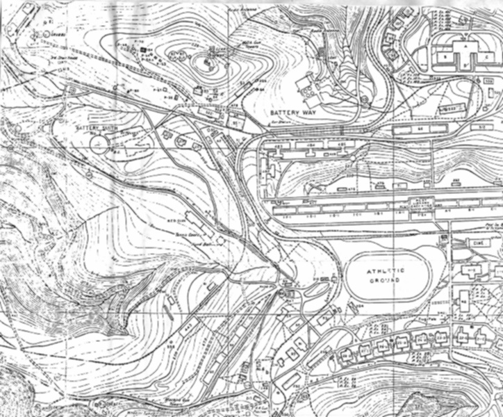 |
A portion of the 1936 Map of the island. Digitizing the entire map would be impossible at this point, so instead we have reproduced the map from a series of photocopies we obtained. The map, which is almost 5 ft long, is available either folded or in a cylinder. See1936 Map for details. (229.6K) |
 |
A widely reproduced drawing of Malinta Tunnel, featuring the hospital and QM laterals. (28.6K) |
 |
Beyond the QM laterals are the NAVY Laterals. This map was drawn by Ed R. Michaud in 1983 based upon his research into the storage of silver and gold in the 1941-42 period, and cannot be vouched for, particularly in the now collapsed areas. There are, in fact, four Navy tunnels on the western side of Malinta Hill, named Queen, Roger, Sugar and Tare. It's not known whether the Q-R-S-T lexicon is of any significance, though Don Abbott has recorded 20 entrances of varying sizes which exit and ventilate the area. (40.6K) |
 |
A detailed scan from the 1936 Map, highlighting the bottomside area, and placing into both scale and context the Malinta Storage System. A copy of this map can be purchased. Go to 1936 Map. (204K) |
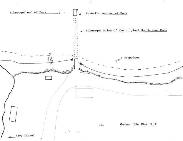 |
This map was drawn by ex-USN Diver Ed R. Michaud in 1983 based upon a number of dives he made around the South Mine Dock area. Ed has marked the location of two torpedoes, which he wants folk to leave well enough alone if they want to stay alive. (27.6K) |
 |
Another map prepared by Ed Michaud in 1983 based upon his dives under and immediately adjacent to the South Mine Dock. Ed confidently marks the areas he says he found some silver pesos and some centavos, because 'they're not there anymore'. (26.2K) |
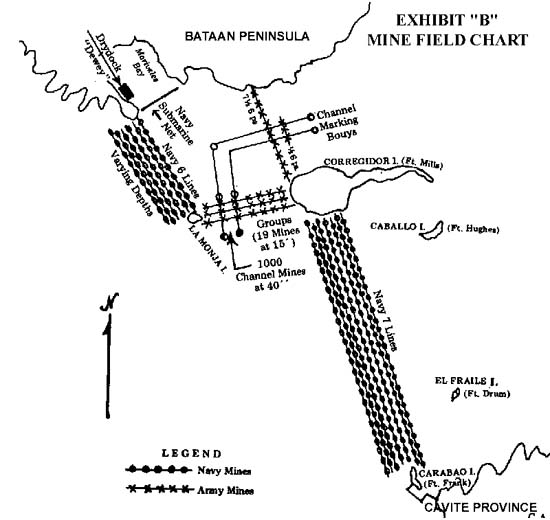 |
Exhibit "B" to the Moore Report, this illustrates the mine fields which linked Corregidor to Bataan to the north and Cavite in the south. Both the Army and Navy minefields are shown. (50.1K) |
 |
Battery Monja, which is one of the most exciting destinations for the intrepid Corregidor hiker, is located via this diagram. Most people who attempt to find it by following the South Shore Road have been frustrated by the heavy undergrowth and the now indistinct profile of the road. Best take a banca and approach it from the beach. Or visit it via Don Abbott's "E" Company Attack on Battery Monja web page. (111.8K) |
 |
This detail of Battery Monja illustrates the almost perfect defensive positions the Japanese were able to adopt in defence of their positions . It also shows the plan of the tunnels, the entrances of which have long been blocked. Entrance is only via the casemate. (59K) |
 |
Battery Ramsay was virtually obliterated when a direct aerial hit penetrated its magazine, courtesy of The Jolly Rogers. During the siege in 1941-42, Al McGrew manned a MG pit in front of gun #1, and he's applied his talents in illustrating the battery as it then was. (79.7K) |
 |
Battery Way, plan view. Fortunately for Corregidoros, Btty. Way has survived the war, the scrappers, and the tourists. It remains the best example of the battery architecture of the times. (91.7K) |
| Want more maps? Send them in! |
| | 503D PRCT COMMUNIQUÉ NEWSLETTER | |
|
|
|