|
US 99: Inland EmpireSide Trips |
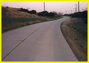 |
An excellent section of a two lane 1930s era alignment of US 99 remains so well preserved that much of the concrete looks as though it had been poured last week. Exit at Cherry Valley Blvd. and turn to the left (west). Turn right on Roberts Rd., the frontage road, which soon goes on the concrete section. (Have a look at the accompanying map for more detail). This section goes down a hill along a rather meandering path with scenery that is little changed from 40 or more years ago. After the road crosses a stream, Roberts Rd. breaks from the old alignment veering to the left. A small part of the old alignment remains a little further on, but is being used as a driveway for a junk collector. Just beyond, the road continued under the freeway and connects with Calimesa Blvd., the frontage road on the east side of I-10. |
 |

 |
US 99 Side Trips: North: Los Angeles (West) Return to the US 99: Inland Empire Travelogue |

Go to the Historic California US Highways Main Page
http://www.gbcnet.com/US99c_side.html