 Travellers
in Montana have been looking for a good road for a long time.
Early road booster organizations included the Montana Highway
Improvement Association, Nelson B. Story, Jr, President; J.A.
Harader, Secretary based in Bozeman, MT and the Montana Good Road
Congress, H.W. Brown, President; P.N. Bernard, Secretary, based
in Kalispell, MT.
Travellers
in Montana have been looking for a good road for a long time.
Early road booster organizations included the Montana Highway
Improvement Association, Nelson B. Story, Jr, President; J.A.
Harader, Secretary based in Bozeman, MT and the Montana Good Road
Congress, H.W. Brown, President; P.N. Bernard, Secretary, based
in Kalispell, MT.
Banff - Grand Canyon Road
Description :
Runs from Alberta border at Port of Piegan south along US 89 to
Great Falls, then south along I-15 to Butte, then east on MT-2 to
Jct MT-41, then south on MT-41 to Twin Bridges, then east on MT
287 to Jeffers finally US 287 south to the Idaho border
Major Cities :
St. Mary, Choteau, Great Falls, Helena, Boulder, Butte, Twin
Bridges, Jeffers
History :
Joined two national parks, Canada's Banff and Grand Canyon.
Beartooth Trail (Bear Tooth Trail)
Description :
Ran from Laurel south along US 212 to Wyoming border north of
Beartooth Pass
Major Cities :
Boyd, Red Lodge
History :
Columbia Sportwear named a clothing line after this route.
Billings-Cody Way
Description :
Ran south from Billings along US 310 to Wyoming border south of
Warren
Major Cities :
Warren
History :
Possibly also called Billings-Cody Road
Black and White Trail
Description :
Ran from Red Lodge to Absarokee along MT-78
Major Cities :
Roscoe
History :
Runs along Rock Creek, rebuilt from 1931 to 1936.
Black Trail
Description :
Ran from Mondak (currently Snowden) south, jumping into North
Dakota along ND-58, to Fairview, then south on MT-200 to Sidney,
then MT-16 to Savage
Major Cities :
Fairview, Sidney
History :
Passes thru Dore, ND
Buffalo Highway
Description :
Ran from Glacier National Park to Wyoming border south of Warren
Major Cities :
Choteau, Great Falls, Ryegate, Billings
History :
Future
Central Montana Highway
Description :
Ran from Glendive along MT-200 to Armington?
Major Cities :
Lindsay, Circle, Jordan, Sand Sprs., Mosby, Grassrange, Forest
Gr., Lewiston, Armington
History :
Future
Clarks Fork Highway
Description :
Ran from Missoula to Idaho border
Major Cities :
?
History :
Future
 Custer
Battlefield National Highway
Custer
Battlefield National Highway
Description :
from Wyoming Border south of Wyola to Glacier National Park
Major Cities :
Lodgegrass, Hardin, Billings, Roundup, Grassrange, Armington,
Great Falls, Choteau, Browning
History :
1920 President: George J. Weiderman of Lewistown, MT
Electric Highway
Description :
Ran from Forsyth west along US 12 to White Sulfur Springs, then
west over MT-360 and MT-284 to Helena, then west on US 12 to
Avon, then northwest along MT-141, then west on MT-200 to
Missoula
Major Cities :
Roundup, Ryegate, Loweth, White Sulfur Springs, Watson, Helena,
Helmville, Clearwater
History :
Future
Geyser to Glacier (Geyers to Glaciers)
Description :
Ran from Yellowstone NP to Glacier NP
Major Cities :
Three Forks, Helena, Choteau
History :
1920 Secretary - M.Max Goodsill
Gallatin Way
Description :
Ran from Bozeman south along US 191 to West Yellowstone
Major Cities :
Salesville, Eldridge
History :
Future
Glacier Bee Line (Y.G. Bee Line)
Description :
Ran from Glacier NP to St. Mary
Major Cities :
Future
History :
Future
Glacier to Gulf Motorway
Description :
Ran from Glacier NP to Wyoming Border south of Warren
Major Cities :
Great Falls, Ryegate, Billings
History :
Extended north to Calgary and south to Brownsville or Galveston
Glacier Trail
Description :
Ran from North Dakota border near Bainville west along US 2 to
Idaho border near Troy
Major Cities :
Glasgow, Malta, Harlem, Havre, Glacier NP
History :
Route between Glacier Park and Benton was via railroad
Interstate Military Highway
Description :
Ran from Havre to ?
Major Cities :
?
History :
Southern Terminus was El Paso
Northern Highway
Description :
Ran from ? to ?
Major Cities :
?
History :
Future (US 2?)
 National
Park to Park Highway
National
Park to Park Highway
Description :
Ran from Wyoming border near Gardiner at Yellowstone NP north
along US 89 to Glacier NP, then west on US 2 to the Idaho border
near Troy
Major Cities :
Livingston, Great Falls, Glacier NP, Kalispell
History :
Future
 National Parks
Highway
National Parks
Highway
Description :
Ran from North Dakota border east of Wibaux west along I-94 to
Billings, then west along I-90 to Three Forks, then north along
US 287 to Helena, then west along US 12 to Missoula, and finally
west on MT-200 to the Idaho border near Heron
Major Cities :
Glendive, Miles City, Billings, Livingston, Helena, Missoula
History :
Future
Old Forts Trail
Description :
Ran from Alberta border at Sweetgrass to Saskatchewan border
north of Loring
Major Cities :
I-15 to Shelby, US 2 to Chester, MT 223 to Fort Benton, US 87 to
Fort Assinniboine (Havre), then MT 233 north
History :
West side connected to Fort Calgary, Fort MacLeod, andFort
Whoop-up in Alberta; East side connected to Fort Walsh and Fort
Battleford in Saskatchewan.
Powder River Trail
Description :
Ran from the Saskatchewan border at Port of Scobey? south along
MT-13 to Scobey, Wyoming Border south of Moorhead
Major Cities :
Scobey, Waska, Volt, south on MT-250 to Wolf Point, then MT-25 to
MT-13 to Circle, then MT-200 to Brockway, then MT-253 to Terry,
then I-94 to Miles City, then MT-59 to Broadus, then Moorehead RD
to Wyoming border.
History :
Complete trail extended north to Moose Jaw, Saskatchewan and
south to Colorado Springs
Regina - Yellowstone Highway
Description :
Ran from Saskatchewan border at Port of Whitetail to Yellowstone
NP
Major Cities :
Flaxville, Poplar, Riverside, Astell, Richey?, Paxton, Circle,
Brockway, Terry
History :
Probably followed Yellowstone Highway to Yellowstone NP
Skalkaho Highway
Description :
Ran from Butte west along I-90 to Opprtunity, then west on MT-1
to Porters Corners, then west on MT-38 to Hamilton
Major Cities :
Anaconda
History :
Crossed Skalkaho Pass (elev. 7,280 ft)
Sunshine Trail
Description :
Ran from Alberta border at Sweetgrass south along I-15 to Butte
Major Cities :
Great Falls, Helena, Boulder
History :
Extended north to Edmonton
Theodore Roosevelt International Highway
Description :
Ran from North Dakota border east of Bainville along US 2 to the
Idaho border west of Troy
Major Cities :
Glasgow, Malta, Havre, Glacier NP, Kalispell, Libby
Alternate route:
North from Kalispell to Eureka along US 93, then south along
MT-37 to Libby
History :
Future
Utah-Idaho-Yellowstone Highway
Description :
Ran from Idaho border along US 20 to West Yellowstone
Major Cities :
None
History :
Future
Vigilante Trail
Description :
Started in Kalispell, ended in West Yellowstone
Major Cities :
Poison, Ravalli, Missoula, Garrison, Butte, Helena,
History :
Markers showed lynching dates
Yellowstone Trail
Description :
Ran from North Dakota border east of Baker along US 12 to Miles
City, then I-94 to Billings, then I-90 to Idaho border at Lookout
Pass
Major Cities :
Fallon, Miles City, Billings, Livingston, Butte, Missoula
Alternate routes:
Spur from Livingston along US 89 to Yellowstone NP
History :
Future
If you enjoy the auto trails of Montana, then you may need
help finding a Montana
campground. There are lots of wonderful campgrounds in Montana
that allow you to enjoy the beautiful scenery of the state!
CREDITS:
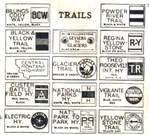
Color Auto Trail trailblazers and trail information from Dave Schul
Route information and Trail Table from 1926 Rand McNally Road
Atlas
Route information from 1927 Clason's Road Atlas.
Montana Highways Front
Page