Go to the Public
Roads Website
In February 1994, the American Society of Civil Engineers (ASCE) designated the Dwight D. Eisenhower System of Interstate and Defense Highways as one of the "Seven Wonders of the United States." (Other "wonders" include the Golden Gate Bridge, Hoover Dam, and the Panama Canal.) As ASCE noted, the interstate system has often been called "the greatest public works project in history." It not only linked the nation, but it boosted productivity and helped sustain a more than tenfold increase in the gross national product since the start of the program in 1956. It is the backbone of the world's strongest economy. However, the story of the interstate system is really the story of its individual segments, many of which were engineering wonders in themselves. The following list discusses just a few of these segments:
I-10 in Arizona
To resolve longstanding controversies, the final section of I-10, the Papago Freeway in Phoenix, which opened in August 1990, was built partly as a depressed freeway. It is covered by 19 side-by-side bridges that form the foundation for a 12-hectare urban park. A graceful arched bridge maintains traffic on the historic alignment of Central Avenue and allows pedestrians to cross the freeway. The Margaret T. Hance Park was built on the deck to establish a connection between the neighborhoods bisected by the freeway.
Also in Phoenix, the interchange of I-10 and I-17 is known as the Stack - a visually pleasing facility that serves transportation needs. Completed in May 1990, the Stack consists of four levels, eight ramps, and 347 supporting piers. It is Arizona's first fully directional, multilevel, freeway-to-freeway interchange. Arizona Highways called the Stack "practical sculpture in concrete."
I-10 in Louisiana
In Louisiana, a 60-kilometer (km) section of I-10 across the Atchafalaya Swamp received design awards even before it opened in March 1973. The elevated roadway was constructed from precast segments, which were cast at a plant on Lake Pontchartrain and then floated by barge through a network of streams and canals to the Atchafalaya River Basin. There, large cranes placed the roadway portions on top of the supporting columns.
I-15 in Arizona
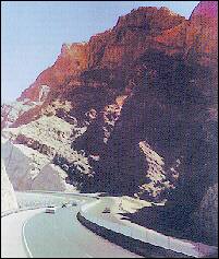
I-15 through the Virgin River Gorge is a scenic wonder through a 500 million-year-old gorge. Construction of I-15, which opened in 1973, included re-channeling the Virgin River 12 times. "Somehow," Arizona Highways magazine said in 1988, construction of I-15 "enhanced rather than distracted from nature's handiwork."

I-35 in Minnesota
In Duluth, the Leif Erikson Tunnel, opened in October 1992, has been honored by the Federal Highway Administration (FHWA) and others for its use of cut and cover tunnels, architectural design treatments, and extensive landscaping to integrate the freeway into the surrounding urban environment and create a pleasing driving experience.
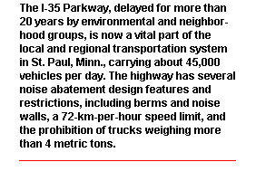
In St. Paul, controversy over I-35E resulted in a unique parkway design - four lanes, no trucks that weigh more than four metric tons (9,000 pounds), a speed limit of 72 km per hour (45 miles per hour), trees and shrubs in the median, and decorative fencing and lighting to blend with downtown redevelopment plans.
I-66 in Virginia
Initiated as a continuation of I-66 from Front Royal, Va., I-66 inside the Capital Beltway was planned as an eight-lane freeway into Washington, D.C. However, it ran into citizen opposition and litigation. Following several public hearings and a review of all available material, U.S. Secretary of Transportation William T. Coleman Jr. approved the highway, but as a four-lane freeway (instead of the eight lanes originally proposed) with extensive mitigation measures, such as noise walls, a hiking/biking trail, and landscaping, as well as room in the median for the Metro light rail line. To accommodate travel demand with reduced lanes, the lanes in the direction of peak-hour traffic were restricted to high occupancy vehicles. The resulting freeway was hailed as an example of an environmentally sound highway.
I-68 in Maryland
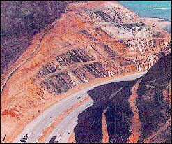
Sideling Hill in western Maryland had been an obstacle to transportation for centuries. Old U.S. Route 40, the modern descendant of the National Road (initiated as a federal project in 1806), executed a treacherous hairpin curve to get around the obstacle. When Maryland officials decided to build an interstate highway through western Maryland to connect I-79 in Fairmont, W.Va., with I-70 and I-81 in Hagerstown, Md., they decided they needed a straightforward crossing of the mountain. To avoid a prohibitively steep grade, they would blast a 116-meter-deep cut into the top of the 536-meter (m) mountain. Doing so required blasting, scraping, and hauling 3.44 million cubic meters of shale, sandstone, and other rock while maintaining traffic on U.S. 40.
In addition, stringent erosion and sediment control requirements, aimed at protecting the trout streams that crisscross the route, complicated the task. An article about the cut noted that when the blasters were done, "They had achieved an engineering marvel: a breathtakingly beautiful man-made rock wall, revealing in tilted, multi-colored layers of sedimentary rock 350 million years of geologic history." When I-68 opened in August 1991, it included the Sideling Hill Exhibition and Tourist Information Center, housing geological exhibits. The center includes a fenced walkway onto the Sideling Hill road cut, as well as a fenced pedestrian bridge across I-68.
I-70 in Colorado
"I-70 follows the Colorado River past manicured mountains, fertile valleys, and breathtaking canyons." That is the way the American Automobile Association describes I-70 between Grand Junction and Denver. The construction of this segment of I-70 involved a series of spectacular feats.
The 2.75-km-long Eisenhower Memorial Tunnel under the Continental Divide is the longest tunnel built under the interstate program. The first bore opened in March 1973, and the second bore opened in December 1979.
A section just west of Denver is a monumental natural art work. The freeway is cut through a prominent terrain feature called the Hogback, formed 50 to 80 million years ago by the gigantic upheaval that produced the Rocky Mountains. The cut has broad terraces that have been used to help teach geology.
Vail Pass is an example of the innovative designs and construction techniques used on I-70 to preserve the sensitive and scenic mountain environment.
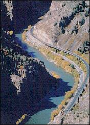
Glenwood Canyon was one of the most challenging projects in the interstate highway system. The highway is a world-class scenic byway and an outstanding environmental and engineering project. Forty-plus bridges and viaducts - including precast box girders; precast I-beams; cast-in place, post tensioned box girders; welded steel box girders; and a tunnel - were used to minimize damage to the setting.
I-70 in Utah
The section between Green River and Fremont Junction crosses the San Rafael Swell, a large geologic uplift containing rugged and scenic terrain in a near-desert climate. Of one segment, Henry Helland, director of the Utah State Department of Highways, said in June 1968: "This project follows a drainage known as Spotted Wolf Canyon, a canyon so narrow in spots I was able to reach both sides of the canyon walls before construction began."

I-75 in Florida
Florida's Alligator Alley - formally called the Everglades Parkway - between Naples and Miami was a two-lane toll road that has been upgraded to interstate standards as part of I-75. Because of concern about the future of the endangered Florida panther, the reconstruction included underpasses that allow the panthers and other wildlife to cross under the highway. Drainage was improved to enhance the flow of water within the Everglades. Making the highway "panther-friendly" was especially sensitive because the concern expressed by Florida's schoolchildren played an important part in having the Florida panther named the state animal.
I-80 in Nebraska
While constructing a 260-km stretch of I-80 through the Platte River Valley of Nebraska in the 1960s, highway builders created a "Chain of Lakes" in accordance with plans worked out jointly by the State Game Commission, the state highway agency, and the Bureau of Public Roads (FHWA's predecessor). Contractors obtained sand and other fill material for the roadbed from low areas along the Platte River. Groundwater then rose to fill the "borrow pits" and form more than 50 lakes. The lakes can be used for swimming, boating, fishing, and wildlife refuges. Called "an imaginative bonus" of I-80, the Chain of Lakes prompted one journalist to write in 1966: "There is a delightful but dangerous new malady - Nebraska Interstate-itis. ... The whole problem was that chain of lakes right alongside the interstate and those doggone fisherman ringing their banks."
I-90 in Washington State
In Seattle, the last 13 km of I-90 presented a unique challenge among urban freeways. The section includes the world's largest soft-ground tunnel, Mt. Baker Tunnel; excavations to drop the roadway an average of 9 m below grade; covers that will reunite neighborhoods; a new floating bridge, which is in essence a bridge built on pontoons; a pedestrian bicycle trail from Seattle to Bellevue; and a linear park across Mercer Island.
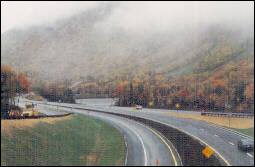
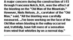
I-93 in New England
What happens when an interstate highway jeopardizes a state symbol? That was the question with I-93 through Franconia Notch, N.H., which features "The Old Man of the Mountain," a granite outcropping that resembles an old man's face. It is also known as "The Great Stone Face," the name used by Nathaniel Hawthorne in an 1850 tale. Many people feared that construction of a typical interstate highway would create vibrations that would undermine the outcropping. The result was a compromise.
The 16-km stretch of I-93 through Franconia Notch includes segments of typical interstate highway, a three-lane parkway, and a two-lane parkway. In addition, a 14.5-km bike path was constructed. Materials such as naturally stained wood on structures, stonework on bridges, and unpainted weathered steel all help to keep the park-like atmosphere and natural beauty of the Notch intact. The I-93 Franconia Notch Parkway opened in June 1988.
In Boston, Mass., I-93 is undergoing one of the most dramatic transformations in interstate history. The Central Artery was built as an elevated freeway through downtown Boston in the 1950s at state expense. It was incorporated into the interstate system as part of I-93. In addition to being considered an eyesore, it didn't function very well as a highway. In the 1970s, state officials began contemplating a plan to rebuild I-93 as a tunnel.
The plan was controversial because it was costly, had potential environmental impacts, and could disrupt traffic for years. It took nearly two decades to get to construction, but work is now under way. Under the final plan, traffic will be maintained on the elevated freeway while the I-93 tunnel is constructed below it. The project remains controversial and is one of the most challenging engineering tasks ever undertaken as part of the interstate system. It also may prove to be the location where the last interstate construction dollar is spent.
I-94 in North Dakota
The original plans for I-94 called for a 70-m-long bridge over Sweet Briar Creek 40 km west of Bismarck and for a double concrete box drain to carry Crown Butte Creek under I-94. Instead, at the suggestion of local conservationists and sportsmen, the roadway, which opened in October 1964, was built as part of Sweet Briar and Crown Butte dams, helping to create recreational lakes. The project resulted from the cooperation of the North Dakota Highway Department, the Bureau of Public Roads, the North Dakota Water Conservation Commission, the North Dakota Game and Fish Department, the Morton County Board of Park Commissioners, and the Morton County commissioners.
I-95 in Maryland
The 2.75-km Fort McHenry Tunnel in Baltimore, Md., is the largest underwater highway tunnel and the widest vehicular tunnel ever built by the immersed tube method. That's remarkable enough, but what makes it even more remarkable is that it was built on time and at a savings of $100 million. The tunnel has one of the world's largest ventilation plants with a total of 48 fans. It also has a sophisticated control system that includes a computer-assisted traffic control system, communication and signing systems, and a monitoring room served by television cameras throughout the tunnel.
Originally, I-95 was to be carried across the Patapsco River on a bridge. Community objections and concerns about the impact of a bridge towering over historic Fort McHenry resulted in the decision to build the tunnel. (During the War of 1812, when Francis Scott Key saw the flag flying over the fort after an all-night bombing attack, he was inspired to write the words of our national anthem.)
The tunnel was constructed in sections on land, floated to the site, and submerged in a trench. "Spoil" dredged from the river bottom to create the trench was used to create 109 hectares of land near the Dundalk Marine Terminal. Overall, the tunnel cost $750 million and opened in 1986.
I-105 in California
In Los Angeles, the 27-km I-105 Glenn Anderson Freeway/Transitway (formerly the Century Freeway) was one of the last of the urban interstates to be built. It opened in October 1993. It has been called Los Angeles County's "first high-tech roadway" because it features the latest in highway technology, including sensors buried in the pavement and links to computers that allow technicians to monitor traffic flow. Meters help regulate traffic on ramps connecting I-105 to four freeways. There are closed-circuit television cameras to alert officials to accidents or other incidents. In addition, Green Line light rail trains will operate in the median.
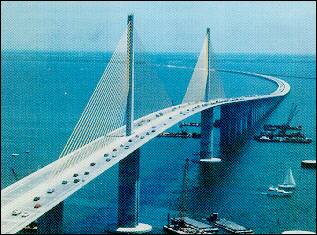
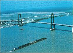
I-275 in Florida
On May 9, 1980, the freighter Summit Venture rammed the pier of the southbound Sunshine Skyway Bridge on I-275 across Tampa Bay. The main span collapsed, sending 35 people to their death. The Florida Department of Transportation decided to replace the bridge with a 6.6-km concrete segmental cable-stayed span that has been called "a one-of-a-kind landmark."
At the time, cable-stayed construction was a relatively new technique in the United States, which had imported the concept from Europe. (In a conventional suspension bridge, parallel sets of large cables are suspended between the towers with smaller cables hung vertically from the large cables. The smaller cables support the roadway. In a cable stayed bridge, the small cables are attached directly to the tower, and they splay out in rows "like the strings of a harp.") The new bridge cost $230 million and opened in February 1987. (The old northbound span has since been removed.) The result has been widely hailed for its beauty as well as its utility.
A review in The New York Times said the "startlingly beautiful [bridge] soars over the water with a lyrical and tensile strength." The review added that the Sunshine Skyway Bridge "may well rank as the most impressive piece of large-scale bridge design in this country in half a century."
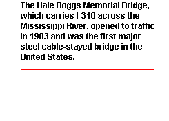
I-310 in Louisiana
The I-310 Luling bridge Ä the Hale Boggs Memorial Bridge - built by the Louisiana Department of Transportation and Development across the Mississippi River west of New Orleans, was the first major steel cable stayed bridge in the country. When this beautiful, $135 million bridge opened in 1983, it received many honors for its design. The beauty of the bridge is in its simplicity - a classic example of form following function. In fact, its beauty encouraged other states to employ cable stayed technology.
I-395 in Virginia
When construction began in the 1940s on the Henry G. Shirley Memorial Highway, it was designed to accommodate traffic generated by the Pentagon, then also under construction. Added to the interstate system as I-395, the highway had been upgraded over the years into one of the Washington, D.C., metropolitan area's main traffic arteries. The Shirley Highway features the first exclusive bus lane built in the United States.
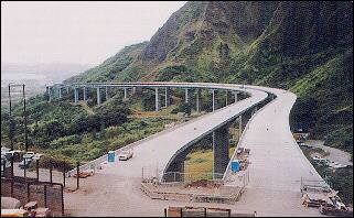
H-3 in Hawaii
In Hawaii, interstate routes are numbered H-1, H-2, and H-3. The 24 km H-3 is the largest construction and public works project ever undertaken by the state. H-3 connects the Kaneohe Marine Corps Air Station to the Pearl Harbor defense bases, passing through the Koolau Mountains to join the windward towns of Kailua and Kaneohe to the leeward cities of Pearl City and Honolulu.
To accomplish this goal, H-3 consists of leeward and windward viaducts joined by a 1,500-m trans-Koolau tunnel. The windward viaducts are spectacular 1.6-km-long twin structures segmentally constructed, precast, prestressed, box girder viaducts. The twin 1.6 km-long leeward viaducts consist of cast-in-place, prestressed, segmental superstructures. Overall, the project is designed to serve traffic while minimizing impacts on a sensitive environment.

Richard F. Weingroff is an information liaison specialist in the Federal Highway Administration�s Office of the Associate Administrator for Program Development.
| Turner-Fairbank Home | FHWA Home | Feedback | Index |
Go to the Public
Roads Website