The Redemption of the Lower Schuylkill
The river as it was
The river as it is
The river as it should be
By John Frederick Lewis
City Parks Association, Philadelphia, 1924
Press of Enterprise Publishing Company, Burlington, N. J., U. S. A.
Profusely illustrated, this volume clearly describes the condition of the Schuylkill River below the Fairmount Dam in Philadelphia, both before and after industrial and sewage pollution drastically altered its character. Lewis ends with his vision for the Lower Schuylkill, and a plea for its implementation: "Scores of cities with but a fraction of Philadelphia's population, a tithe of her wealth, and a vastly larger per capita debt, might be cited as having recognized the wisdom of water front reclamation [and] sewage disposal by other means than by fouling their most valuable asset. Why should Philadelphia not do likewise?"
Text conversion using ReadIris OCR software, and scans of illustrations, completed June 2004 by Adam Levine, Historical Consultant, and Natalia Broz, PWD Public Education Intern, using a copy of the book in the Philadelphia Water Department Archives.
Links to illustrations follow the text. All illustrations except those from the collection of the Historical Society of Pennsylvania have been scanned.
INTRODUCTION
THE CITY PARKS ASSOCIATION OF PHILADELPHIA, upon January 17, 1924, held a reception at the Hall of the Historical Society of Pennsylvania, 1300 Locust Street, to meet the Hon. W. Freeland Kendrick, Mayor of Philadelphia, and Mrs. Kendrick.
The following address upon "The Redemption of the Lower Schuylkill," was delivered by Mr. John Frederick Lewis. Mr. Lewis is President of the Art Jury of Philadelphia, and served for many years as a member of the Executive Committee of the "Comprehensive Plans Committee of the City of Philadelphia," and as Chairman of its Sub-Committee on Parks and Parkways, during which period the Parkway was opened upon its present lines from City Hall to Fairmount. His intimate knowledge of the subject upon which he speaks justifies the publication of the address.
Mr. Eli Kirk Price, President of the Association, introduced Mr. Lewis.
ANDREW WRIGHT CRAWFORD,
Recording Secretary.
[PAGE 1]
Mr. Mayor, Ladies and Gentlemen:
I felt considerable diffidence about accepting the gracious invitation to address you, until your distinguished President suggested that I speak upon the Redemption of the Lower Schuylkill. I then felt a call to duty not unlike that of the Disciples to preach the Gospel, because I know of no work that our beloved City could presently undertake, which would be more in accord with the Gospel of the Last Dispensation, than that of regenerating the Lower Schuylkill so that it might bring fresh air, pure water, and comfortable homes, to the hundreds and thousands of our fellow citizens, who live in the wards below the Dam. The welfare of any community is an absolute unit, and no section should be overlooked in the work of betterment. The health and happiness of the poor are vital to the health and happiness of the rich. Disease, physical, moral and political, originates in the lowest stratum of society, and the best way to prevent and eradicate such disease, is to raise the deadly level. Redeeming the Lower Schuylkill from being an open sewer, with its dump collecting station, its oil refineries, abattoir, chemical and paint manufactories, and garbage disposal plants, and making it a beautiful river, with bordering parkways upon both banks lined with trees, and with open places for public use in the peninsulas formed by the river's windings, is a work of social uplift worthy of a second Messiah.
There is no reason why the Schuylkill below the Dam should not be as beautiful and useful as it is above it, and there is no reason why the Dam, which is a purely artificial construction, should act as a curse to bar further improvement to the naturally beautiful river which flows for miles so close to our doors.
[PAGE 2]
THE RIVER AS IT WAS
The Lower Schuylkill was formerly quite equal in beauty to the Upper. When the river was first discovered by the Dutch in 1628, they called it the Varsche Rivierte, that is, the little fresh water river, and its waters., always noted for being purer and colder than those of the Delaware, can again be made fit for human consumption, and its breezes meet and proper for our people to breathe.
In the early history of the City, splendid groves of sycamores, oaks and willows lined the Lower River, and under their grateful shade were charming walks our forefathers enjoyed during the heat of Summer. At Spruce Street, upon the Schuylkill, there was a grove of majestic oaks of especial beauty. It was used by the Baptist Society from which to lead their candidates to the water for immersion. It was known as the Baptisterion, and Morgan Edwards, the old Society's Pastor, thus describes it, as it existed prior to the Revolution:
"Large oaks offering fine shade, underfoot is a green, variegated with wild flowers and aromatic herbs, and a tasteful house is nearby for dressing and undressing the novitiates."
In the midst of the grove was a large stone, with hewn steps, where the old Pastor stood to exhort his people, and around which the faithful knelt in prayer. The grove was not only beautiful for the purpose intended, but also delightful as a popular resort.
It would, indeed, be an ardent convert who would now suffer himself to be immersed in the filthy water at the foot of Spruce Street.
Watson in his Annals of Philadelphia, records that the scenery of the Lower Schuylkill was once picturesque and beautiful. Benjamin Franklin, he says, was accustomed to walk along the river with his companions Osborne, Watson, and Ralph, and to sit in the woods in [PAGE 3] restful converse, but he adds, that the banks are now "much changed to a busy, hustling, coal mart," and that such change commenced in 1824 with the opening of the Schuylkill Canal between Philadelphia and Reading.
Let us walk together, in imagination, along the river as it was in the olden time, and starting from Spruce Street, where I was born and still live, go north under the trees along the east bank. Just above Chestnut Street were the Water Works, which at the beginning of the Nineteenth Century supplied the City with drinking water. A large fore bay, eighty feet wide, two hundred feet long and of a depth of three feet below low tide, served as the intake, arid from thence there was an open canal and tunnel to a well, from which the water was elevated into a brick tunnel extending down Chestnut Street to Broad, and from Broad to Centre Square, where the Public Buildings now stand. Here the water was raised to a reservoir, and carried by wooden pipes down Chestnut Street and Mulberry Street (now called Arch), to public hydrants convenient for our citizens, and, also, into the few private dwellings whose owners could afford to introduce it. It is significant of those good old times, that among the first users of this cold and pure water, were four breweries, whose sparkling arid refreshing output tempered both the cold of Winter and the heat of Summer.
At Market Street, the site of the Middle Ferry, was one of the first great bridge enterprises in America, the so-called Permanent Bridge over the Schuylkill. The company which built it was incorporated in 1798, and succeeded in opening the bridge to the public in 1805. The bridge itself was 550 feet long, spanning the river in graceful arches, arid with its abutments and wing walls had a total length of thirteen hundred feet. It was one of the only two covered wooden bridges in the world, and our forefathers' love of beauty and their sympathy for [PAGE 4] the charms of the river, led them to adorn its entrances. They report in the quaint language of the last century: "The master chisel of William Rush, has at length embellished the entrances of our bridge, with emblematical representations of Agriculture and Commerce, for the indissoluble union and mutual benefit whereof, such structures furnish indispensable facilities."
The old bridge was altered in 1850, to allow the City Railroad to connect with the Columbia and Pennsylvania, and was destroyed by fire in 1875.
At Callowhill Street, the site of the Upper Ferry, a floating bridge was constructed after the Revolution. It opened up a beautiful country, by way of Haverford Meeting as far as Goshen in Chester County, and by means of the Great Valley was used by the settlers of the Welsh Tract. It was washed away by a freshet in 1789, was restored, but was again carried away in 1810. Then the Legislature chartered a company which built the famous Wernwag Bridge in 1812, enhancing the beauty of the river by its single wooden span of 343 feet, ninety-eight feet longer than any other then in the world. Burned in 1838, it was succeeded by the equally famous Ellet Suspension Bridge-the first of its kind in America, except the one at the Falls, and which stood with all its lightness and grace, until 1875 when it was succeeded by the present structure.
Just below the Callowhill Street Bridge, was a famous attraction of the Lower Schuylkill, the Wigwam Baths at the foot of Race Street. More beautiful than its name would indicate, it was a public garden as well as a water resort. It was opened in 1791, and at once became one of the objective points for strangers visiting the City. Priest, in his Travels Through the United States in 1793-1797, refers to it as "a garden and tavern romantically situated on the banks of the Schuylkill." Alas! how far the romance has fled from the Schuylkill end of Race Street!
[PAGE 5]
Let us cross at Callowhill Street to the west side of the river. We get a beautiful view down the river as well as up. The Water Works at Fairmount were completed in 1815, the water being pumped by steam directly from the river to the reservoirs on Fairmount, and in 1822, the dam was built to substitute water power for steam.
Upon the west bank below Callowhill Street was the "Upper Burying Ground," so called, which originally belonged to the old Friends' Meeting, at Centre Square, and, adjoining it, further down the river as far as Market Street, and lying between the west bank of the river and the old road which led to the Upper Ferry, was the "Lower Burying Ground," which also belonged to the Centre Square Meeting. These old burying grounds were among the earliest in Philadelphia. The Centre Square Meeting was abandoned by the Friends a few years after the City was founded, but the Society continued to use these burying grounds without other title than the original assignment of them to the Meeting as a place of interment. Considerable dispute arose, from time to time, as to the actual ownership of the land, and the dispute, more than once, reached the Legislature of Pennsylvania.
As early as 1809, a Committee of the House of Representatives to which the matter was referred, reported that the Friends' had no title to the land, and that it was vested in the Commonwealth, but a petition was thereupon presented by the Friends' to the Committee, which subsequently reported, after hearing testimony concerning the title, that there was presumptive evidence that the land had been held by the Friends for one hundred and twenty years, and positive evidence that it had been exclusively so held for sixty years.
The dispute, however, still continued, and, in 1819, the Society formally relinquished its title, to the Board of Health of Philadelphia, upon the express condition that [PAGE 6] the title thus relinquished should be without prejudice to the right of individuals to the use of the property "as a burying ground and place of interment of the dead forever." Hardly thirty years however, went by, before this trust was vacated, and both Burying Grounds were devoted to other uses, the "Lower Burying Ground" becoming an abattoir and drove yard.
During the one hundred and twenty years that the Friends had used the ground, there were hundreds, probably thousands, of interments made therein of the earliest residents of the City. The site was laid out with walks and drives, had a central pavilion or rotunda, and was a place of quiet charm and beauty.
All the way from Fairmount, formerly called Morris Hill, to the mouth of the River, were beautiful banks with lovely vistas, where the River turns upon itself before it reaches the Delaware. Upon the east side of the River at South Street, was the residence of the Hon. John Kinsey, "on the way as thou goest to ye Lower Ferry," now included within the grounds of the Naval Asylum. It was known as the "Plantation House," and the mansion is described as a "superior" one, surrounded by tall cedars with beds of flowers and shrubs. It later became the residence of James Pemberton, son of Israel Pemberton, Jr. Upon the other side of the Ferry Road, was the "Evergreens," the residence of Israel Pemberton, Sr., also a fine estate; and "down in the neck" was "Wilton," the residence of James Turner, referred to in the old Annals of the City, as "a fashionable resort for genteel strangers." The grounds were laid out with innumerable clumps of trees and ranges of shrubs, together with many statues of fine marble which had come originally from a Spanish prize.
Above Gray's Ferry on the west bank, was "Woodlands," the country residence of William Hamilton, one of the stateliest mansions of by-gone Philadelphia. Even [PAGE 7] in its present condition, the old building and its surrounding cemetery, give some idea of its elegance a century ago. William Hamilton was a lover of beauty, and the fact is sometimes forgotten, that he was one of the earliest patrons of art and collectors of pictures in this Country.
At the Lower Ferry on the Schuylkill, later known as Gray's Ferry, was the first public park in Philadelphia, laid out upon the plan of the public gardens of London. It was opened shortly after the Revolution, and attained a well merited popularity. Delightful walks through shady groves and lovely beds of shrubs and flowers, made it a charming spot, and many references to it have been made by visitors who enjoyed its hospitality. In the Columbian Magazine, City poets are said to "have grown delirious" over its beauties. One writer records, that it is remarkable how little public gardens are disordered by a mixed multitude, "the reason, of this must be," he says, "that even rude minds are harmonized by the genius of the place and are awed into veneration for its beauty. I place elegant gardens among the nurseries of national fortitude. The Bible has laid the scene of man's first innocent and happy existence in a garden, and represents his future mansions among the just, under the emblem of a paradise planted with the trees of life, and watered by crystal streams that spring from the Throne of God."
Gray's Garden continued as a public park until the beginning of the Nineteenth Century, and there is no reason why both banks of the river from the Dam to Fort Mifflin on the west, and to League Island on the east, should not be one continuous garden with driveways, and foot ways, through avenues of trees for the entire distance it winds its way through the heart of our City.
Gray's Garden was not the only popular place on the Lower Schuylkill. Many Nurseries and Flower Gardens existed on both sides of the river, and though designed particularly for the cultivation and sale of trees and [PAGE 8] flowers, they became in consequence of the beauty of their surroundings, and the elegance with which they were laid out, places of public resort.
Gray's Ferry, however, was always regarded as the most important entrance to the City. It was the outlet for the King's Highway from Chester, Wilmington, and the South. A bridge was built there by the British in 1778, during their occupancy of Philadelphia, in order to obtain communication with their shipping, and as an avenue of possible retreat. It was a floating bridge of logs, with large hinges so that it might rise and fall with the tide, and was kept in position by chains and anchors at its shore ends. The central part was movable to allow for the passage of shipping. Across this bridge in 1789, General Washington passed, on his way to New York, to be inaugurated as the Nation's First President. A triumphal arch, twenty feet high, decorated with laurel and other evergreens, was erected where each end of the bridge met the beautiful banks of the river. Under the westernmost arch a small crown of laurel was suspended by a line leading to a pine tree on the high and rocky bank, where the line was held by a boy on watch for Washington's approach. Eleven flags lined the bridge, representing the eleven States which had then ratified the Constitution. A signal flag was placed in the Ferry Gardens to give notice of the General's arrival, and when he appeared, and was passing under the arch, the laurel crown was lowered by means of the boy with the line, until, as the records say, "it descended on his venerable head." What the Father of his Country, who was but fifty-seven, did with the crown, or how he received such treatment is not recorded. His Excellency was at once saluted by a discharge of artillery, which doubtless drowned his remarks, and he was escorted into Philadelphia by a large body of troops together with the President of the State, and an innumerable concourse of respectable citizens.
[PAGE 9]
There is no reason why this hallowed spot, should not be made fit again to receive the President of the Nation.
Below Gray's Garden upon the west bank, was and still is, the old residence of John Bartram, dating from early Colonial times. Its surrounding grounds of seven acres were planted with rare shrubs and trees, and laid out into attractive walks, extending to the edge of the river, all now happily to be replanted and maintained by the Commissioners of Fairmount Park. In this old garden, plants were first cultivated in America for medicinal purposes. Indeed, there is no more romantic spot, hallowed with memories of the past, within the boundaries of Philadelphia, and none in some respects more inaccessible. It has a personal romance for me, because the old date stone at the south end of the house gable, is inscribed with the legend "John and Ann, 1731."
A little further down the river, at Passyunk, which was a much frequented resort for Indians, the Dutch erected nearly a century before Bartram built his house, Fort "Beversrede," at what they called "a very convenient spot"--the name of the Fort being suggested by its proximity to an old Indian trail of that name, which led from the Susquehanna to the Schuylkill. It was the first settlement of white men within the present geographical limits of the City of Philadelphia.
Upon the east side of the Lower River were the properties of Andrew Bankson, William Snowden, Peter Dalbo and William Clayton, and upon the west side, those of White, Hanly, Jones, Bartram and Gibson, and then, below Gray's Ferry, as shown on Scull's Map of the City, published in 175ø, were the properties of Hannis, Penrose, Cox, Lord, Morris, Rambo, and Cadwalader--all now but a memory--driven away by the ruthless invasion of smoke and sewage-the name alone, Penrose Ferry Bridge, marking the vicinity of their former existence. [PAGE 10] The Bridge at the Ferry, which was kept by Samuel Penrose, was not built until 1853, was reconstructed in 1860, and replaced in 1878.
William Penn intended Philadelphia to be a city of beauty as well as brotherly love. In his Instructions to his Commissioners for laying out "the great towne," as he calls it, he said, "make your choice where it is most navigable, high, dry and healthy, and not swamp…each house should be in the middle of the breadth of its ground so as to give place to gardens…that it might be a green country town, which might never be burned and might always be wholesome." He expected the citizens to live upon the banks of the Schuylkill, as well as upon those of the Delaware. He therefore located the old City upon the narrowest part of the peninsula between the two rivers, and laid out upon the Schuylkill some of the first Lots ever placed on the City Plan. Many families settled on the Schuylkill. Its waters attracted shad, and other fish, in larger schools than those of the Delaware. In fact, so famous was the Lower Schuylkill for its fishing, that when the Dam was constructed in 1822, and the fishing at the Falls spoiled, the "Schuylkill Fishing Company, of the State in Schuylkill," which was founded in 1732, by some of the early settlers, was moved from the Falls, where it had been for ninety years, to Rambo's Rock, opposite Bartram's Gardens. Here it remained until the fish in the Schuylkill were poisoned by sewage, and it was forced to move again. So beautiful was the location at Rambo's Rock, that when Lafayette visited Philadelphia in 1825, he was entertained at the Club House, by the Governor and Members, and a numerous company of guests. What would a distinguished stranger think now were he entertained at Rambo's Rock?
So much for the Lower Schuylkill that was. So much for the splendid imagery and exquisite melody which inspired Thomas Moore, when he was here in 1824:
[PAGE 11]
"Alone by the Schuylkill a wanderer rov'd,
And bright were its flowery banks to the eye."
and again:
"The stranger is gone--but he will not forget
When at home he shall talk of the toils he has known,
To tell with a sigh what endearments he met
As he strayed by the waves of the Schuylkill alone."
[PAGE 91]
THE RIVER AS IT IS
Let us now look upon the Lower Schuylkill as it is. Let us go to the top of the old Morris Hill, where the City is crowning a magnificent Parkway with a stately and majestic Art Gallery, and, facing the setting sun, look up the river and then down it, "upon this picture and upon this--Hyperion to a Satyr." To the right, there is as lovely a prospect as any great American city affords. The Schuylkill winds in a graceful curve, with rolling banks upon both sides, and avenues of trees and beds of shrubbery, all uniting as a framework for the silver surface of the river, upon which pleasure boats are plying hither and thither, every place in view affording health and happiness to thousands of our fellows. To our left, without even turning around, we see at our feet immediately below the double decked bridge at Callowhill Street, an enormous dump heap, to which ashes, waste paper, tin cans, old bottles, and domestic waste, are carted across this magnificent Parkway, between the Art Gallery at the west and the Cathedral at the east, and then loaded into barges to be hauled downstream and dumped upon the banks of the river, less the dust and waste paper which blows off on the journey and can be seen floating upon the surface. We can see, and if the wind is in the right direction, can smell the sewage from a square mile of West Philadelphia beyond the Zoological Gardens, discharged by a ten-foot sewer into the river just above the Dam at the locks of the Schuylkill Canal, from which it descends to the river below, and by merely turning our head, we can also see, and if the wind is in the right direction, can also smell, the sewage discharged just below the Dam by the main intercepting sewer, which extends from Shawmont Avenue, eight miles up the river, and collects sewage from many square miles of Manayunk and of the northern and western part of the City, fouling [PAGE 92] the water immediately below the Art Gallery, and where prior to the construction of this sewer in 1883, there were swimming pools and bath houses. Upon the west bank is an open sewer in the neighborhood of the dump, and five main sewers, at Mt. Vernon Street, Spring Garden (how appropriate the name for a sewer outlet!), Powelton Avenue, Chestnut and Walnut Streets, further pollute the already filthy waters, by the sewage from West Philadelphia, as far west as Forty-second Street, and as far north as Spring Garden.
The conditions upon the east bank are even worse. Main sewers are at Wood Street, Race, Arch, Market, Sansom, Chestnut, Locust, Spruce, Pine, Lombard, South, Bainbridge, Christian, Ellsworth, Reed, Jackson, and Pollock Streets and at Passyunk Avenue are twin sewers eight feet in diameter. All of them, a total of some twenty main sewers, excrete the domestic and industrial waste of nearly 1,000,000 people into the "Varsche Rivierte," which carries it back and forth by the movement of the tide, within a short distance of the city dwellings, until the entire accumulated filth, is mixed with the waters of the Delaware for the use of our fellow citizens to bathe in, or drink if they can, at Marcus Hook, Chester, Wilmington, and New Castle.
But this is not all. There is an oil refinery above Filbert Street, between Thirtieth Street and the west bank of the river, and, close to the bridge of the Pennsylvania Railroad, where strangers to the City can see and smell it, there is a drove yard and abattoir which is a blot on the City's escutcheon. It has done more to stop improvement in its vicinity upon the west bank of the river, and even upon the east, than any other deleterious agency. It is a breeder of disease directly, and by means of flies which it naturally attracts. This wretched establishment has long out-lived every excuse for its present location, and the patience of our citizens should no longer be imposed [PAGE 93] upon in permitting its continuance. There is no past nor present sense for its situation in the geographical centre of the City. Meat markets should of course be accessible to the homes of our people, but when the abattoir was placed where it is, refrigerator cars were unknown, and slaughtering thousands of cattle and hogs in our very midst, should now be indicted and abolished as a public nuisance. Market Street, which it adjoins, is the widest, longest, and most important east and west thoroughfare the City includes. When the abattoir was projected in November, 1874, a Committee of Citizens made a protest against it, as "a grave injury to our City," and such it has been ever since. It was designed to do away with small slaughter houses, but it was a short-sighted mistake, in removing one nuisance, to establish another and greater one. A city which derives its income chiefly from taxation upon improved property, should not allow in her midst, a source of offense, which every sensible seller of valuable real estate prohibits by express restrictions in his deeds. As a matter of fact, when the abattoir was established, building lots in its neighborhood, sold by the same owner which conveyed to the abattoir, inserted in its deeds of conveyance a clause: "Under and subject to the restriction and express agreement between the parties hereto, that no slaughter house, skin dressing establishment…nor building for offensive occupation, should at any time hereafter be used or erected upon any part of the granted premises."
In the protest against the location of the abattoir, it is said that no one who has ever come within range of a car-load of hogs, need be reminded of the foul odors generated by them when crowded together for transportation, and the vast numbers which frequently accumulate in the pens, can scarcely fail to contaminate the atmosphere for long distances. The protest logically observes, that, however great might be the desire of the managers both from praiseworthy and economical motives, to gather up all the filth and refuse, yet the storing and slaughtering [PAGE 94] of so many thousands of oxen, hogs, and sheep weekly, must necessarily cause, not only deleterious effluvia but also large amounts of decomposing animal matter must be daily drained into the Schuylkill, and the very efforts which may be made by constant and abundant flushing, to keep the slaughter houses clean, can only result in increasing the pollution of the stream. This pollution, notwithstanding the sewage the river has already received, is evident as the blood and offal float upon the water. The river at Race Street is but 380 feet wide, and at Arch Street 425 feet. Its waters are shallow, especially along the western shore. Its tide is cut off by the Dam, and when the water is low during periods of drought, which frequently occur, the supply is insufficient to permit much downward current, with the inevitable result that the "Varsche Rivierte," whose every prospect would please were not man so vile, is turned into a longitudinal cesspool. It is not necessary to say more. The oil refineries, paint works, chemical factories, and garbage disposal plants further down the river, merely darken conditions already too foul for polite discussion.
Have I overdrawn the picture or used too dirty a brush in painting its colors? I think not. The very air itself is blackened with the smoke and dirt of many factories upon the river, which could be better located by a beneficial system of zoning, where they would not be as near our Art Gallery, our beautiful Park, and the houses of our people.
Comparatively few Philadelphians ever see the lower Schuylkill, except from the window of a railroad train, as they are leaving or entering the City from the south. The old residential district west of Broad Street, and from Vine to Pine, is being gradually deserted. Our mayors, directors of public safety, other city officials and many prominent people, have moved to the suburbs, and are therefore unfamiliar with the facts, but there are, nevertheless, [PAGE 95] many thousands of humbler folk, who still live in the wards next the river below the Dam, some at Twenty-fourth Street or even closer, and their health and happiness are entitled to just consideration. They know, as I do, how offensive is the stench, when the air is heavy and the wind blowing from the southwest.
The responsibility for designing and constructing the municipal sewage system, rests with the Bureau of Surveys, and for many years it has realized that the present practice of discharging crude sewage into the Schuylkill, needs imperative and immediate change.
On July 3, 1913, the Bureau printed a report on the collection and treatment of the sewage of Philadelphia. It is signed by those efficient public servants George S. Webster, Chief Engineer (now of the Delaware Bridge Commission), George E. Datesman, since deceased, and W. L. Stevenson, assistants. It is a terrible indictment of existing conditions. It says that below the Dam, the sewage of about five hundred thousand people is discharged into the river, that the volume of diluting water is inadequate to inoffensively dispose of the sewage, and the velocity of the flow insufficient to maintain the sewage matter in suspension.
Of the total area of the City--130 square miles--about forty per cent drains directly into the Schuylkill. In the course of the Bureau's investigations of the lower river, a system of floats was established, at which samples of the river bed, and of the water, were taken and tested. The report shows that the entire bottom of the Schuylkill, from Fairmount to its mouth, is covered with deposits of sewage origin, except in the vicinity of Christian Street, where there is a rock bottom and higher velocities flow, and at Oregon Avenue, where there is a sharp bend in the river; that the water of the river for its entire length is grossly polluted; that sewage matter floats upon the surface; that the water is turbid and highly discolored; that the putrefaction of the sewage matter deposited on [PAGE 96] the bed of the river causes an almost constant ebullition of gas, and that at low tide, when the sloping banks are exposed, they show the putrefying black mud of sewage origin. These conditions, the report continues, prevent the attractive development of the banks of the river, either for pleasure or business purposes, and as a consequence there has grown up adjacent to them a number of oil refineries and garbage reduction plants.
The volume of sewage is so vastly greater than the volume of the diluting water, that the available oxygen which is necessary to purify the sewage is exhausted. Whether the filth theory of disease is sound or not, is a matter of small consequence when we admit, as we must, that disease originates in filth and is spread by flies and other insects, and that the impregnation of the ground with sewage contaminates beneath the surface nearby ponds and wells. While filth itself may' not be the actual cause of disease, it is the vehicle by which disease itself is carried, and experience has shown that cleanliness is the vital essential to sanitation. No municipal work, except a pure water supply, the report continues, has greater effect upon the health and comfort of a community, than a properly designed and operated sewage system, by which domestic filth is promptly removed in underground channels to its final dispersal into inert constituents; that sewers make possible the abolishment of privy wells, which are always a menace to public health, by the pollution of ground water and the transmission of disease through flies. Sewage in the Lower Schuylkill has utterly destroyed its fishing, and made its otherwise available banks, unfit for human habitation, and undesirable even for industrial purposes.
The report which I have quoted was made in 1913, over ten years ago, since which time the volume of sewage polluting the Lower Schuylkill, has vastly increased with the increase of population, while the volume of the river water has remained the same. Conditions are therefore [PAGE 97] worse now than when the report was penned. That document significantly concludes: "Sewage contains the wastes of domestic life and industrial activity, a considerable part of which is organic matter and therefore subject to changing conditions. When sewage is discharged into insufficient volumes of diluting water, this change occurs by putrefaction, which is offensive." … "The discharge of large quantities of crude sewage at frequent points into the streams and rivers which flow through the city, causes deposits, which decay, give forth malodorous gases, and create discomforts to the people, who live or pursue their various occupations in the vicinity; such conditions also result in the depreciation of property values, and make it undesirable to construct manufacturing establishments along their banks, where the men and women operatives are compelled to pass the entire day under unpleasant and uncomfortable conditions." …"Foully polluted streams flowing through sections of the city, convert what might be attractive residential sections into slum districts, where buildings are erected and housing conditions exist, which foster unwholesome conditions of living."
Were Tom Moore to visit the Lower River now, he would sing:
"Alone by the Schuylkill a wanderer rav'd And rank were its sewery banks to the nose."
and again:
"The stranger is gone--but he will not forget,
When at home he shall talk of the toils he has known,
To tell with a retch what stenches he met
As he strayed by the waves of the Schuylkill alone."
[PAGE 98]
A line or two needs no paraphrase:
"Nor long did the soul of the stranger remain
Unblest by the stench he had happened to meet,
And much did he fear it would retch him again,
'Ere the threshold of home could be prest by his feet."
It may be to laugh, but it must be to cry.
The picture has not been overdrawn. With the river banks and bottom foul with deposited sewage; with sewage in suspension and visibly floating upon the surface of the stream, and with the blood and offal of slaughter houses and the waste of oil refineries, chemical factories and paint works, the conditions are impossible to overstate. The waters of Nimrim have become desolate…and the waters of Dimon full of blood. Much of our City's most available territory has been cursed by our own wickedness, as the land of Egypt was cursed by God at the mouth of Aaron. "Stretch out thy hands upon the waters of Egypt, upon their streams, upon their rivers, and upon their ponds, and upon all their pools of water…the waters that were in the river were turned to blood… and the fish that was in the river died; and the river stank; and the Egyptians could not drink of the waters of the river and he sent divers sort of flies among them which devoured them."
Probably nowhere in America, nor in any civilized country, can there be paralleled in a great city, the conditions which now exist on the Schuylkill River below the Dam.
The ancient Egyptian, when he passed through the Valley of the Shadow of Death, and saw the Solar Disk under the Canopy of Heaven, and upon either side the lions of "Yesterday" and "Tomorrow," believed that he was judged by forty-two divine assessors to whom he [PAGE 99] must confess his conduct in the world he had left, and not the least of these confessions, before he was allowed to enter the Hall of the Two Truths and appear before Osiris, in whose presence his soul was weighed in the balance by Thoth, was this: "I have not polluted the waters." May we of this generation so live, that when our summons comes to wend our way through the same Valley, we may be able to make the same declaration when we appear before a Greater Judge than Osiris.
[PAGE 133]
THE RIVER AS IT SHOULD BE
From the river that was, and the river that is, let us now turn to the river that should be. Other cities with less population and larger debts than Philadelphia have disposed of their sewage and improved their river banks, and if Philadelphia may not lead in these movements, she should at least be able to follow. As the Survey Engineers say in their report of 1913:
"London, the largest city in the world, with a population of six million situated on the banks of a river with but little larger flow of upland water than the Schuylkill, disposes of its sewage by removing about seventy-five per cent. of the suspended matter by chemical precipitation, and depends upon the oxidizing power of the great tidal volume of the Thames, for the ultimate purification of the dissolved impurities in the tank effluent."
And again:
"The magnificent development of the Thames Embankment at London; the boulevards and esplanades along the banks of the Seine in Paris, and the commercial development of the Elbe at Hamburg and Dresden; and the attractive appearance of the Main at Frankfurt; and of the Danube at Vienna, could not have been possible if these streams were as foully polluted as the Schuylkill River is at the present time between Fairmount Dam and the mouth."
The work need not, and cannot be done all at once. A beginning should be made by condemning immediately, the narrow strip of land upon the west bank of the Schuylkill below the Dam, between Thirtieth Street and the bulkhead, which would permit a park and embankment driveway from Spring Garden Street to Arch. It could connect with the west drive along the river above the Dam, and then below Callowhill Street Bridge, could be [PAGE 134] connected by spurs from the north and the south, with Powelton Avenue and Thirtieth Street. The total assessment for the year 1924, of all the properties required for this vast purpose, is the comparatively small sum of $265,000.
On the east bank, the City should likewise condemn the small triangle of ground between Bonsall Street and the east bulkhead, extending from the lower side of the Parkway at Fairmount, south to Vine Street. Taking this triangle would enable a park and embankment driveway to be opened immediately, from the Plaza in front of the Art Gallery, to Vine Street, from whence a spur should connect with Arch. The total assessment for the year 1924, of all the properties required on the east bank of the river between the Parkway and Arch Street to permit this improvement, amounts to but $560,000.
The construction of these west and east Schuylkill Driveways, and especially that upon the east, would open up traffic routes through existing streets, which would tend to relieve the present congestion in the middle City. The East Driveway could connect with Twenty-third Street and Gray's Ferry Road, and from thence to Twenty-fourth Street, to Twenty-fourth Avenue at the McKean Parkway, arid from this intersection across Vare Avenue to Penrose Avenue, and the proposed extension of League Island Park. This connection would permit access to Fairmount Park by the Thirtieth, Thirty-sixth, and Forty-eighth Wards, the latter alone containing nearly five square miles of territory, and then, by means of Penrose Ferry Bridge, with the Fortieth Ward on the opposite side of the river, containing over eight square miles.
The improvement of the Lower Schuylkill should begin, not end, with such acquisition. The West Schuylkill Driveway should be continued along the bulkhead, past Franklin Field, through the Botanical Gardens east [PAGE 135] of the Commercial Museum, then in front of Woodland Cemetery, which the City ought to take over sooner or later, and then still along the river bank past Bartram's garden to Fort Mifflin. Under this Driveway, or under such part of it as proves available, an intercepting sewer should be constructed in accordance with the plans of the Bureau of Surveys, by means of which all of the sewage not discharged, both above and below the Dam from West Philadelphia, could be conducted to a disposal plant near Fort Mifflin.
The East Schuylkill Driveway should also be continued, which, if the tracks of the Baltimore & Ohio East Side railroad are not abandoned, (and it is quite unnecessary to have railroads on both banks of the Schuylkill), could be arcaded, and the surface rights above the tracks thus reclaimed for the Driveway. Such East Side Driveway, with its spur at Arch Street, should follow the bulkhead to Schuylkill Avenue, across Gray's Ferry Road to the east and west side of University Parkway, which extends from Reed Street to Vare Avenue, where it would connect with Schuylkill Avenue, and by Passyunk Avenue to the river bank which it would follow, then by Pennypacker Avenue past McKean Park to Penrose Avenue and the extension of League Island Park to the west.Under this East Schuylkill Driveway could be constructed, like that under the west, an intercepting sewer to gather the sewage now emptying into the lower Schuylkill, and conduct it to a disposal plant near the mouth of the river, or more economically, a sewer under one Driveway could bear all of the accumulated sewage by the installation of pumping stations, as recommended by the Board of Surveys, the sewage being carried under the Schuylkill in an inverted siphon conduit. Such a layout of Driveways and traffic routes is not a mere dream but a practical and economical enterprise. It would not entail vast cost. The traffic circuits created would be chiefly [PAGE 136] along streets and avenues already the property of the City or ripe for improvement.
Viewing the subject from an aesthetic standpoint, the east and west Schuylkill Driveways, could be appropriately planted with trees and made splendid avenues for the traffic of all the east and west streets upon both sides of the River. Trees would grow with vigor in the rich sewage impregnated soil they would find at their roots, and then, in course of time, the peninsulas formed by the windings of the river, could be turned into public parks and playgrounds for the vast population now living in the Schuylkill wards, and which will become more vast as available building sites were created in consequence of such improvement. Much low, miasmatic and otherwise unhealthy land could be reclaimed for human habitation.
The sewage impregnated mud at the bottom of the river could be pumped up and spread over the low ground where it would be splendid for park purposes. The river would be cleaned and the land fertilized at the same time.
Such reclaimed ground would accommodate many times the twenty thousand houses which our city of homes is now short of the urgent needs of her people, and it has been estimated that the ground alone would be worth seventy million dollars, the taxes upon which would defray many times the interest upon the necessary expense of reclamation.
The Legislature of Pennsylvania, by the Act of April 22, 1905, asserted her sovereignty over the waters of the State to protect the public health, and sooner or later if the Lower Schuylkill is not redeemed by grace, it will be redeemed by law. Discharging sewage into any of the waters of the State is made a criminal offence, and though the Act excepts municipalities which have been operating a public sewer system at the date of the Act, it does not [PAGE 137] permit an extension of such system, and requires a permit from the State Commissioner of Health and the consent of the Governor and Attorney General, and such permit shall not continue for more than two years. The City is now acting under such a permit, and the Northeast Sewage Disposal plant, which will purify the waters of the Delaware at the Torresdale Pumping Station, is the first effect of the enforcement of this Act.
In discharging crude sewage into the Schuylkill, the City is now doing a thing, which if done by a private individual would be attended by fine and imprisonment.
Making a city beautiful is investing money, not spending it. It is creating and increasing municipal capital, not diminishing it. Someone has said that beauty carries its dower in its face, and someone else, that beauty draws more than oxen. What is true of personal charm is true of municipal attraction. Beauty in a city is economy, while ugliness is waste. Visitors are attracted by splendid parks and parkways, by playgrounds and handsome buildings; and Philadelphia, situated as she is on the direct line between Washington, Baltimore and New York, is in an advantageous position to detain the visitor, who may perchance fall in love with the splendid manhood or exquisite womanhood for which the City is famous, and make it a permanent home.
Looking at the subject from a purely utilitarian standpoint, the benefits to the municipality need no spokesman.
The immediate solution, even though in part, of the transportation problem north and south, is not the least of these advantages. Every city like Philadelphia, built between two rivers, presents the problem of traffic congestion. The body municipal needs arteries of circulation as well as the body corporeal. In each case the restriction of the free power of locomotion, (which Blackstone defines as personal liberty), means immediate congestion, [PAGE 138] with all the ills such stricture engenders. Besides the interference with trade and industry, there usually results from such restriction, cramped, unhealthy and immoral housing, with its attendant disease and crime. The congestion which now so hampers the freedom of circulation in Philadelphia, results chiefly from inadequate avenues for movement north and south. Broad Street is the only really available passage in these directions from the City center, and Delaware Avenue the only passage on the eastern boundary. There is now practically no possibility of motion upon either of the Schuylkill River banks, while the north and south streets, between the Delaware and the Schuylkill, in the older parts of the city are so narrow, and so built upon with many storied buildings, that motion even upon foot is impeded, while vehicular transportation is constantly retarded and often stopped entirely. City Councils can now regulate traffic in the built up portions of the City only by curtailing the public's privileges, and thereby producing one nuisance nearly as annoying as that which is abated, creating the wretched makeshift of one-way streets, which sometimes require a detour of eight blocks to reach a spot one block off, or by stopping the parking of all vehicles in certain localities, so that another nuisance is created, when the vehicles denied the right to park, are kept going round and round the block, trip after trip, while their owners stand on the lookout to catch their cars on the fly. Such nuisances increase congestion instead of lessening it.
Then too, purifying the lower Schuylkill and the construction of an east and west Schuylkill Driveway, will vastly increase the value of all real estate thereto appurtenant, and will lead to the improvement of such real estate and to the increase of the City's revenue by taxation. As the Survey Bureau reported:
"The removal of the sewage by the intercepting arid collecting sewers, will make available the shores of the river for commercial purposes and the laying out of [PAGE 139] attractive boulevards and esplanades. Undesirable and unsanitary conditions having been removed, the banks of the creeks will then be suitable for development for park and pleasure-ground purposes, all of which will tend to increase the welfare of the city and promote the comfort and prosperity of its citizens."
Experience in other cities has always shown that the finest sites are upon improved river or lake banks, and the highest taxed buildings, hotels for example, are ordinarily located upon such banks,. whereas in Philadelphia, the ugliest portion of the City is unquestionably its Schuylkill River fronts, both in East and West Philadelphia, and it lowest assessed land, almost at farm rates, is river bank property, which should properly be assessed at the highest. The Schuylkill banks are just as susceptible to improvement, as the North and South banks of the Charles River at Boston, or the Revere Beach; as the Susquehanna at Harrisburg; or the Delaware at Trenton; or the Lake front at Chicago, where over eleven hundred acres of Park land are now being reclaimed, extending from Grant Park in the centre of the city to Jackson Park on the south side; or the water front at Hartford; or the East Battery and South Battery at Charleston; or the water front at Toronto-a city one-fifth the size of Philadelphia and which has just completed four miles of Parkway and well advanced a commercial water front development of three miles more; or the water front at Columbus, Ohio, which is creating a civic centre using both sides of the river and which in 1922 by a vote of two to one selected a river front site for her new city hall; or the river and lake fronts of almost every important city in Switzerland where people are quick to see the direct money value of municipal beauty; or the Rhine at Basle, where the old Hotel "Drei Konige" has been a public inn since the tenth century; or the Aare at Berne, which is built on a peninsula like Philadelphia, with less than one-tenth our population. What shall we say of [PAGE 140] the water fronts at Constance; at Neuchatel; at Zurich; at Geneva; and at Lucerne; of the Malecon at Havana and the Bay at Rio de Janeiro? Scores of cities with but a fraction of Philadelphia's population, a tithe of her wealth, and a vastly larger per capita debt, might be cited as having recognized the wisdom of water front reclamation, sewage disposal by other means than by fouling their most valuable asset. Why should Philadelphia not do likewise?
We have recalled the lower Schuylkill as it was, we see it as it is, may we live to see it as it shall be. Our City should not fall behind in the march of municipal progress. She is what we make her, and what we make her depends upon ourselves. Our forefathers made her the first city in the Nation. What they accomplished in spite of adverse conditions is amazing. She led in every movement, political, industrial, literary, scientific and artistic.
In her Carpenters Hall assembled the first Continental Congress. Washington was there made Commander-in-Chief of the American Armies. She spurred the Colonial delegates, by her unfaltering patriotism, to adopt the Declaration of Independence, and was the first to proclaim it with fearless indifference to the consequences. The Colonial Delegates here debated and adopted the Constitution of the United States, and from 1790 to 1800, she was the Federal capital, where the Supreme Court sat and Congress assembled, and here Washington penned his wise and touching Farewell Address to the American people. Her plain Old Statehouse, is richer in historical association with the progress of human freedom, than any other building in the world.
She set up the first American printing press, built the first paper mill, erected the first type foundry, organized the first fire insurance company, opened the first bank, [PAGE 141] erected the first mint for the coinage of money, churned the waters of the Delaware with the first steamboat ever operated in America, constructed the first Government ship under the Federal Constitution, and laid down the first experimental railroad track ever placed on American soil. She founded the first circulating library, printed the first magazine, published the first Bible, and issued the first daily newspaper on this Continent.
She organized the first association in America for the study of natural science; equipped the first American Arctic expedition; established the first Medical College, and organized, in the room where the Declaration of Independence was signed, the first art institution in America, and which has continued in uninterrupted existence to the present day. Her people were skilled as mechanics, honest, and enterprising as merchants, and loyal in support of the Government their patriotism adopted, and of the Union, into which the whole country was inseparably bound. Should the descendants of such sires sit supinely by and rest upon the laurels they have won? Should they not unite in making her, if not the biggest, if not the richest, if not the most learned, then the most artistic, the most beautiful, the most comfortable, and the most thoroughly American in adhering to the traditions of the fathers?
ILLUSTRATIONS
THE RIVER AS IT WAS

"Scene on the Schuylkill," engraved by A. W. Graham.
From an original picture by J. Hamilton for Godey's American Views
Frontispiece
"Baptisterion" at Spruce Street, Schuylkill, as it was prior to the Revolution.
From an old line engraving belonging to the Historical Society of Pennsylvania
13

"Baptisterion," looking across the Schuylkill through the Oak Grove, towards the west;
1774, a wood engraving by Van-Ingen-Snyder, from Watson's Annals of Philadelphia
15

Near the site of the Oak Grove and "Baptisterion,"
today: 1924, looking towards the west
17
"View of Schuylkill near Philadelphia," below Fairmount in 1800:
now a municipal dump on the left bank.
From an old line engraving belonging to the Historical Society of Pennsylvania
19

Municipal dump: west bank of the Schuylkill below the Art Museum,
showing the offal and filth floating on the river. Photographed in 1924
21

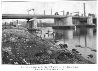
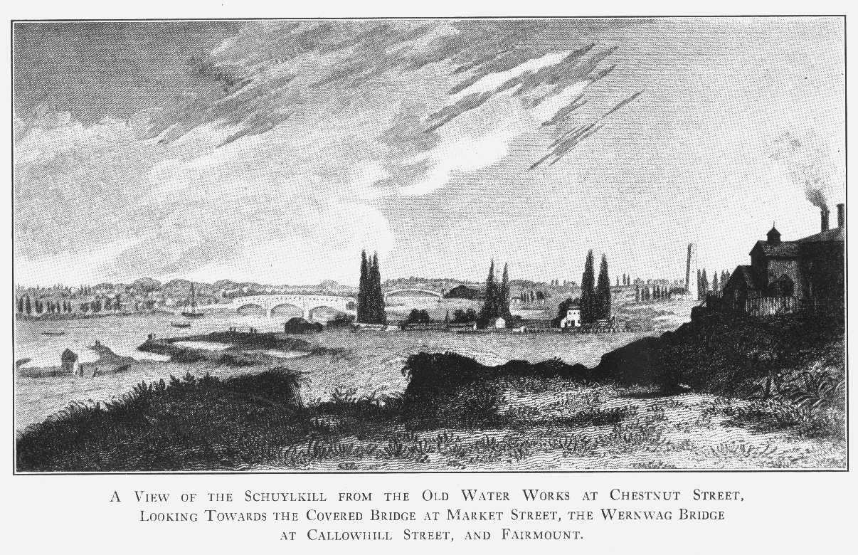
View of the Schuylkill from the Old Water Works at Chestnut Street, looking towards the
Covered Bridge at Market Street: the Wernwag Bridge at Callowhill Street;
and Fairmount. Drawn by Capt. J. R. Watson. Engraved by C. G. Childs.
Published by C. G. Childs, 1827.
From an old line engraving belonging to the Free Library of Philadelphia
23
The Old Water Works at Centre Square (Broad and Market),
supplied with water from the Schuylkill at Chestnut Street.
From an old line engraving belonging to the Historical Society of Pennsylvania,
and after an oil painting by Joshua Shaw
25

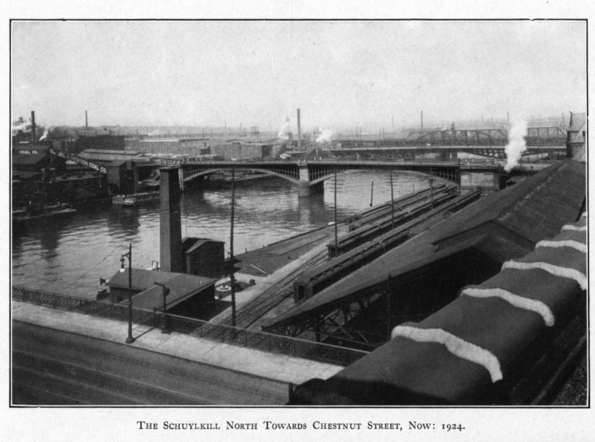
The Schuylkill, looking north towards Chestnut Street, now: 1924
27

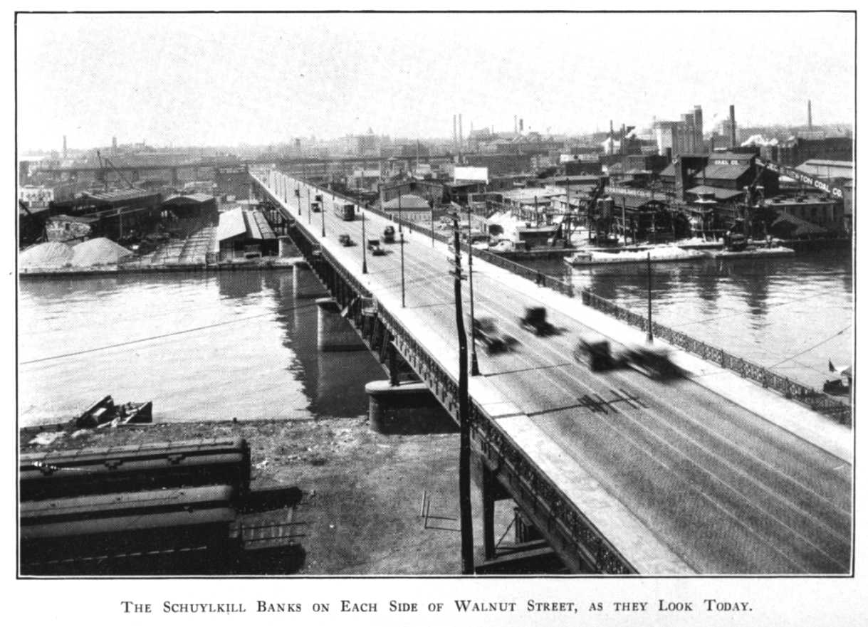
The Schuylkill Banks on each side of Walnut Street Bridge
as they look today
29
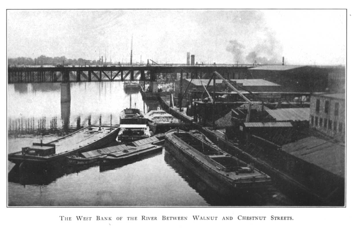
The West Bank of the Schuylkill River between Chestnut and Walnut Streets.
Photographed in 1915
31
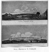
"Lancaster Schuylkill Bridge" (Callowhill Street) and "Schuylkill Permanent Bridge"
(Market Street) from an old engraving by Jacob J. Plocher
belonging to the
Free Library of Philadelphia, and after a drawing by W. Strickland
33
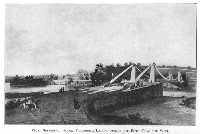
"The Upper Schuylkill Bridge at Philadelphia from the S. E."…
"the greatest known span by near 100 feet." Drawn by C. A. Busby, Architect. Engraved by M. Dubourg Lambeth.
"Published by J. Taylor, 1823. The Framing Designs by Lewis Wernwag." (Callowhill Street.)
From an old engraving belonging to the Free Library of Philadelphia
35
High Street Bridge (now Market) before the bridge was covered. Drawn by W. Birch. Published May, 1805.
Engraved by S. Seymour. From an old print belonging to the Free Library of Philadelphia
37
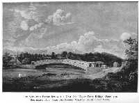
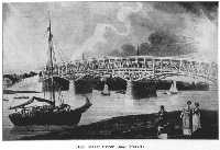
Wernwag Bridge below the Dam from the south east, 1823, near the famous Wigwam Baths, that were, "The Upper Ferry Bridge. Thomas Birch, pinxt. Jacob J. Plocher, sculpsit--Over the River Schuylkill near Morris Street in the County of Philadelphia. Chord of arch 340 feet--whole extent of bridge 400 feet--rise of arch 20 feet--elevation over water 30 feet--the span is greater by 98 feet than that of any other bridge known--the construction is in general new--the principle invented by Lewis Wernwag who was assisted in the execution by Joseph Johnson--general design by Robert Mills, Architect."
"Published by Joseph Delaplaine and Thomas Birch, 1813."
From an old print belonging to the Free Library of Philadelphia
39
Fairmount Water Works with Wernwag Bridge at Callowhill Street.
From an old lithograph by Wild and Chevalier, 72 Dock Street, 1838,
belonging to the Historical Society of Pennsylvania
41
Suspension Bridge at Fairmount, constructed by Charles Ellet, Jr., C.E.
"A. Groome, del. Engraved by Rawdon, Wright, Hatch, & Smilie."
From an old print belonging to the Historical Society of Pennsylvania
43
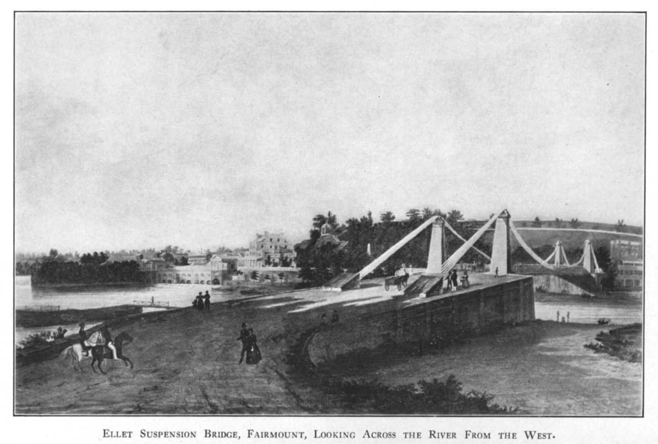
Ellet Suspension Bridge Fairmount, looking across the river towards the west.
"From nature on stone by George Lehman, Lith. P. S. Duval, Phila.
View of the Wire Bridge at Fairmount, Phila. Erected in 1842"
45
Looking down the west bank of the River, as it is now,
just below Callowhill Street Bridge and the Art Museum
47

"Schuylkill Water Works, Philadelphia.
Drawn by W. H. Bartlett, published 1839. Engraved by J. C. Armytage."
From an old print belonging to the Free Library of Philadelphia
49

"Birds-eye View of the City of Philadelphia with Environs,"
showing in the near ground the Upper and Lower Burying Grounds above Market Street,
on the west bank of the river, where the Abattoir now is.
"Engraved by J. Serz, Phila. Published by Charles Magnus & Co., N. Y."
From an old print belonging to the Free Library of Philadelphia
51
View down the Schuylkill from Girard College, 1850,
part of a lithograph by B. F. Smith, Jr., ("J. W. Hill & Smith, del.")
belonging to the Historical Society of Pennsylvania
53
"The Plantation," Pemberton's, site of the Naval Asylum:
from an old wood cut belonging to the Historical Society of Pennsylvania
55
"Woodlands," the residence of William Hamilton. "Drawn by Wm. Strickland."
From an old engraving belonging to the Historical Society of Pennsylvania
57
"Woodlands," residence of William Hamilton,
from a photograph taken about 1860, belonging to the Historical Society of Pennsylvania
59

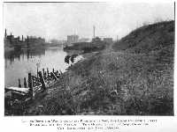
Looking northward across the river towards a sewer and "Woodlands,"
when crossing Gray's Ferry Bridge from the east. A photograph made in 1924
61

Looking across the east bank of the river north of Gray's Ferry Bridge,
over a dump for filth and into an open sewer, and then towards "Woodlands."
From a photograph made in 1924
63
The old bridge of floating logs at Gray's Ferry: looking towards the west.
"Gray's Ferry on the Schuylkill (a Relic of the Olden Time). Engraved by J. W. Steel (from a drawing by G. Lehman in 1828)."
From an old print belonging to the Historical Society of Pennsylvania
65

Gray's Ferry Bridge looking towards the west, showing the beautiful banks and splendid trees.
"Drawn by Lehman. Published by C. G. Childs, Phil a."
From an old print belonging to the Free Library of Philadelphia
67

Today, 1924: The West Bank of the River south of Gray's Ferry Bridge:
the front of what was formerly the beautiful Gray's garden
69

The present state of the east bank of the Schuylkill at Gray's Ferry,
where our citizens met Washington on his way to his inauguration.
Photographed in 1924
71
"An East View of Gray's Ferry near Philadelphia with the Triumphal Arches, etc.,
erected for the Reception of George Washington, April 20th, 1789."
After a painting by C. W. Peale. Engraved by J. Trenchard.
From an old print belonging to the Historical Society of Pennsylvania
73

1924: Looking down the River, East Bank below Gray's Ferry,
where our citizens assembled to greet Washington
75
Old mansion near the west end of Gray's Ferry, a relic of departed glory.
From a photograph taken about 1880 belonging to the Historical Society of Pennsylvania
77
The house of John and Ann Bartram, from a photograph belonging to the
Historical Society of Pennsylvania, taken about 1880
79

Eastwick's Villa, Kingsessing, Pennsylvania, adjoining Bartram's Gardens on the south:
1865, from a drawing by Devereux
81

Philadelphia in 1777. Map of "Environs de Philadelphia par Scull et Heap,"
showing the residences along the banks of the Schuylkill
83

The Schuylkill at Rambo's Rock, from a painting by Eastwick, 1825,
belonging to the "State in Schuylkill."
Photographed by the courtesy of Hon. J. Willis Martin
85

1924: Site of Rambo's Rock as it looks today. Here Lafayette was welcomed!
87

The East Bank of the Schuylkill just above the site of Rambo's Rock as it is now: 1924
89
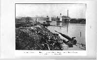
THE RIVER AS IT IS

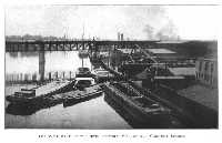
The West Bank of The River below Fairmount: Municipal dump in the foreground,
and the Art Museum in the rear
101

The Municipal dump in action, West Bank of the River below the Art Museum, showing the filth floating on the waters. Photo-
graphed in 1924
103

West Bank of the Schuylkill below Spring Garden Street Bridge,
and showing its disgraceful condition
105

Open sewer near the line of Vine Street on the West Bank of the Schuylkill,
the Art Gallery under construction in the Rear
107

The Schuylkill Banks Abused,
and showing that there is no occupation of any permanent importance except the Railroads
which could run under embankments
109

Near the geographical centre of Philadelphia:
the West Bank of the Schuylkill near the centre of the City, and showing its disgraceful condition
111

The West Bank of the River looking south below South Street:
the river front of the Commercial Museum and the University,
to which students come from allover the Country
113
The West Bank of the River below South Street Bridge,
looking towards the City Hall, in the background: photographed 1924
115
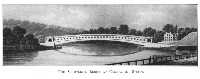
The River Banks looking north towards the new South Street Bridge
which cost over $772,000: photographed in 1924
117

Looking north from Gray's Ferry Bridge towards "Woodlands,"
the former residence of William Hamilton: photographed in 1924
119
The West Bank of the River south of Grays' Ferry Bridge,
and showing how open sewers and filth have replaced former beauty.
Photographed in 1924
121

Just above Passyunk Avenue Bridge:
the West Bank of the Schuylkill looking towards the southeast,
showing the filth on the River and on the Bank
123

The West Bank of the River looking northwest at Passyunk Avenue
and showing the filthy beach and its wretched condition
125

The West Bank of the River looking north from Penrose Ferry Bridge,
showing land which could be reclaimed for residential
Purposes
127

The West Bank of the River looking north from Penrose Ferry Bridge,
showing the filth and black sewage on the River Bank
129

The West Bank of the River looking south from Penrose Ferry Bridge,
and showing its neglected condition
131
THE RIVER AS IT SHOULD BE

Suggested Plan of Redemption.
The Park System of Philadelphia in 1924, with the suggested extensions
(as shaded) along the Lower Schuylkill and Darby Creek
143

Railroad tracks under Pennsylvania Avenue (the Art Gallery under construction, left background)
and showing how the railroad tracks on the Banks of the Schuylkill
could be covered with a driveway
145

The "Philadelphia Inquirer" Building, now being erected over the
Reading Railway tracks at Broad Street, showing how even a
"skyscraper" can be built over a railroad
147

The Banks of the Schuylkill looking south from Walnut Street,
and showing the railroads which could run under embankments
as they are under embankments on the Seine and the Thames
149

Wilkesbarre: the river front is it was
Wilkesbarre: the river front as it is
151

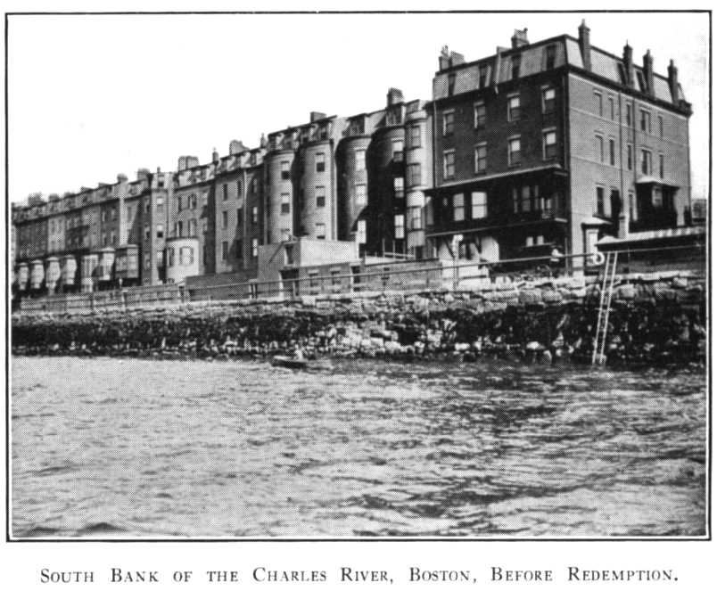
South Bank of the Charles River, Boston, before redemption
153

South Bank of the Charles River, Boston, after redemption
155

The River Front at Trenton, its redemption just begun
157

Toronto water front, before redemption
159

Toronto water front, after redemption
161

Charleston, South Carolina, showing improved water front
163

The Malecon, Havana, before redemption
165

The Malecon, Havana, after redemption
167

Throngs using the Redeemed Water Front of Havana
169

Rio Janeiro water front
171
|


