National Road
National Road
Another of the more famous roads, US 40 traverses the same path as the National Road took. The National Road was created by the United States government under the advisement of President Thomas Jefferson in 1806 to provide a route from the settled eastern seaboard into the central part of the country to open up the Midwest for settlement. It was the first federally-funded interstate highway that ran from Baltimore, Maryland to Vandalia, Illinois. Originally, US 40 spanned the country from Atlantic City, New Jersey to San Francisco, California. With the advent of the Interstate system, the highway was truncated to Park City, Utah.
As for the history of the route in Pennsylvania, the route remains the same outside of the cities of Uniontown and Washington. In Washington, the route followed Chestnut, College (eastbound), Lincoln (westbound) and Maiden Streets. In Uniontown, the route followed Main and Fayette Streets. In 1939, the highway was widened from Washington to Pancake, known today as Laboratory.
The 1940s came with more work done to improve the highway with widening projects near PA 281 and from Addison to the Maryland state line. In 1946, the highway was widened west of Lincoln Hill, east of PA 281 and one mile east of the Youghiogheny River. In 1947, the highway was widened west of Uniontown and the following year from PA 281 past the Youghiogheny River and Hopwood to one mile west of Chalk Hill.
In the 1950s, a dam was constructed across the Youghiogheny River at Confluence, which created the Youghiogheny Lake. Due to this new lake, US 40 had to be routed onto the current alignment. The former alignment can still be seen when the level of the lake is low. One aspect that can be seen is the National Road bridge that crossed the river at the town of Somerfield, which was demolished to make way for the lake.
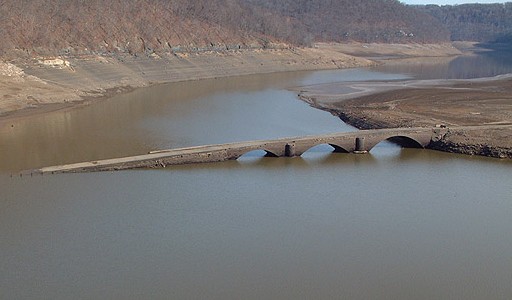
Old National Road bridge re-emerges during a dry spell. (Vince Ferrari)
Another change in routing took place during the decade in Washington. The route was changed to follow Maiden, Franklin, Beau, and Jefferson Streets and replaced a former "Thru US 40" designation that was signed on those streets in 1958. That same year, the highway was divided near PA 281 and west of Uniontown.
The 1960s saw more improvements to the highway with construction starting on a new alignment west of West Brownsville in 1962. The following year that section opened to traffic, including the Lane Bane Bridge over the Monongahela River. In 1968, the alignment from Brownsville to PA 166 was under construction with it opening the following year.
It would not be until 1970 that that section would receive the US 40 designation. Currently, traffic heading west must switch to PA 166 and then enter the expressway. Depending on the routing of the Mon-Fayette Expressway, that expressway stub will connect to the existing US 40 alignment and to the expressway. An odd occurrence took place in 1976, when the southern Uniontown Bypass was shown on the PennDOT map as being under construction. However, the following year it was removed from the map.
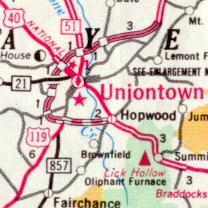
Proposed Uniontown Bypass in 1976.
(PENNDOT)
It would not be until 1991 when construction would officially begin on this section. It was built as a part of the Mon-Fayette Expressway, when work began on the Chadville Demonstration Project from the Uniontown Bypass to Fairchance. In 1994, this southern bypass opened and received the US 40 designation which was removed from the route through Uniontown. For a commentary on the end of the bypass, see the Roadrash page.
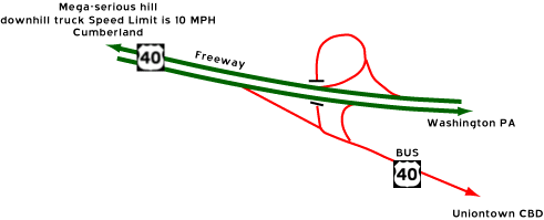
The end of the southern bypass east of
Uniontown. (C. C. Slater)
There are efforts underway to get US 40 designated a federal All-American Road, which would mean millions of dollars to develop tourism along the highway. There are problems that have arisen with all of this good news. The National Road Heritage Park Commission, who does most of the paperwork, lacks elements of leadership such as an executive director. PENNDOT District 12 Engineer Michael Duffalla has cautioned other board members to proceed slowly, fearing that this designation would delay or block improvements. If the highway gets the federal designation, it could mean advertising and marketing the highway across the country and be used as leverage to gain federal, state, and private development dollars. Some of the highways currently designated All-American Roads are the Pacific Coast Highway in California, the San Juan Skyway in Colorado, and the highway taken by civil rights marchers from Birmingham to Montgomery, Alabama.
On June 13, 2002, United States Transportation Secretary Norman Y. Mineta announced that US 40 in Pennsylvania, along with 12 others across the country, became All-American Roads and 23 National Scenic Byways were added to the list of America's Byways. The designation gives the National Road Heritage Park access to new grants. Transportation Secretary Allen D. Biehler along with other state and local officials, cut a ceremonial ribbon on May 8, 2003, to officially mark the National Road as a National Scenic Byway "All-American Road." Donna Holdorf, executive director of the National Road Heritage Corridor, said the designation will give her organization about $24 million to promote tourism to the area. The ceremony was held on the "S" Bridge in Buffalo Township in Washington County.
Construction on a new bridge across the Youghiogheny Reservoir began on October 6, 2003. The $25,380,707.71 project will entail building a new, eight span, 1,730 foot-long bridge north of the existing one and then demolishing the current span. The projected end is February 16, 2006.
|
|
|
|
|
|
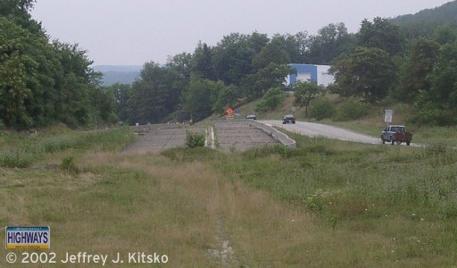 Looking westbound towards Brownsville on what will become an extension to PA Turnpike 43. Originally was built as a part of the Mon Valley Expressway project in the late 1960s. |
|
|
|
|
|
|
|
|
|
|
|
|
|
|
| National Road
Heritage Corridor
The National Road Heritage Park is one of nine special heritage areas in the Commonwealth of Pennsylvania. Each is a nonprofit organization designated by Governor Tom Ridge. The park consists of Washington, Fayette, and Somerset Counties, using the historic National Road as a uniting element for preserving scenic, cultural, and historic resources, as well as restoring and developing existing and new programs and facilities. Website: http://www.nationalroadpa.org/ |
Links:
Exit Guide
US 40 Auxiliary Routes
PA
Turnpike 43
National
Road Heritage Park - Department of Conservation and Natural Resources
National
Scenic Byways: The Historic National Road
Route 40 Improvement Project
The Historic National Pike - Adam Prince
National
Road/US 40 - Doug Pappas
Route 40-National Road - Frank Brusca
Terminus
of US 40 - Dale Sanderson
US 40 in Uniontown - Eli
George
US 40
Junction List - Tim Reichard
Yahoo!
Groups: Route
40
 INFORMATION |
|
| Western Entrance: |
West Virginia state line near West Alexander. |
| Eastern Entrance: |
Maryland state line three miles east of Addison. |
| Length: | 83 miles |
| National Highway System: |
None |
| Names: | National Road George C. Marshall Parkway: US 119 north to US 119/PA 43 south |
| SR Designations: |
SR 0040 SR 0019: Washington to Laboratory |
| Counties: | Washington, Fayette and Somerset |
| Expressway: | PA Turnpike 43 to Brownsville Brownsville to PA 166 US 119 to Hopwood |
| Multiplexed Routes: |
PA 231: Claysville PA 18: Washington US 19: Washington to west of I-79 PA 88: PA Turnpike 43 to West Brownsville US 119: US 119 west of Uniontown to south of Uniontown PA 43: PA Turnpike 43 west of Uniontown to south of Uniontown PA 381: Farmington PA 281: South Fayette County near the Maryland state line |
| Former Designations: |
PA 11 (1911 - 1926) |
  Path of Progress: |
Brownsville to US 119 in
Uniontown Business US 40 to Addison |
 Washington's Trail: |
US 119 to the Maryland state line |
| Area Codes: | 724/878 |


