
Mon-Fayette Expressway
Mon-Fayette Expressway
This highway has been a long time in coming, and it is still coming. Local politicians hailed the new Mon Valley Expressway as a much needed vital link to Pittsburgh which would supplement rail and river links for the area industries. The original plan also included an expressway to Monroeville referred to as the "New 48" as this highway was to replace the existing PA 48. Into the 1980s, maps of Pittsburgh showed this road as being proposed along side the current PA 48. It would have begun at the Parkway East in Monroeville and then followed PA 48 to PA 51, south of where PA Turnpike 43 connects. When the current plan was proposed, PENNDOT and the PTC decided to bring it into Pittsburgh and compensate Monroeville with a spur.
Right of way was cleared including the amusement park that my mother used to go to as a child, Rainbow Gardens in White Oak. Now it is a shopping center called Oak Park Mall and nearly every time we drive past she says, "That used to be my amusement park. They tore down my park to build a road!" Even if she did not know it, mom was a young NIMBYer. I feel a sense of sadness when she says that, because it ended up being destroyed for nothing.
Construction kicked off with a groundbreaking on February 22, 1973, attended by Governor Milton Shapp and Department of Transportation Secretary Jacob G. Kassab and joined by other government officials, which was held in West Pike Run Township along US 40. The $5.9 million project included construction of 1.3 miles of highway encompassing a new bridge to carry US 40 over the expressway, one-half of the full cloverleaf, and four lanes of divided, limited-access highway. The interchange construction finished in 1977. Tom Lyons, an assistant engineer for PENNDOT District 12, estimated that it would be five more years until all sections from I-70 to Centerville Borough would be under contract. Other sections up to the Allegheny County line, although planned, would likely not get built until the 1980s. The cost of the entire route through Washington County was estimated as high as $250 million, depending on final location and inflationary factors.

First sections to planned to see
construction. (Pittsburgh Press)
It was still not decided on what would happen once it reached Allegheny County. Originally it was to link up with the South Hills Expressway, then later plans called for its connection to the Oakland Crosstown Freeway. "Our first estimate for the five sections of the Mon Valley Expressway from near the Route 40 interchange to I-70 was $22 million," Lyons said. "As of last November, the estimate was $47 million." A possible relocation of the Interstate was planned, which led to delays in planning two sections. "We can't go into final design until we know what will happen to I-70," District 12 Deputy Engineer Harold N. Harper said. "Then there's always the question of getting projects put into the state capital budget." The federal government agreed to pay for the expressway on a matching 50-50 fund basis. However, PENNDOT District 12 tried to shift financing to another program, whereby the federal government would pay 70% of the cost and the wait for the expressway would be shortened. However, due to limited state revenue, the construction program ended. Only the cloverleaf at US 40 and a short section of expressway from Exit 32 to 34 would be built, as PENNDOT hit financial straights in the late 1970s and cancelled funding on highway expansion. Construction on most of the Pittsburgh and Philadelphia expressway systems, and I-78 around Allentown and Bethlehem, was put on hold if not cancelled outright.
The savior of the expressway would come in 1985 in the form of the Act 61 legislation, which was the Turnpike Organization, Expansion, and Toll Road Conversion Act, that was enacted and funded completion of the non-connecting sections. On March 26, 1987, then Governor Robert P. Casey committed $40 million to resume construction on the renamed Mon-Fayette Expressway between US 40 and I-70. The name changed to better reflect the areas to be connected by this highway. Casey announced an accelerated design and construction schedule that was to finish the expressway by the mid-1990s. After breaking ground that day on another seemingly dead expressway, Parkway North, he visited my alma mater California University of Pennsylvania to pledge continued support from his administration to the project. "I have made a commitment that my administration will do everything possible to revitalize the Mon Valley," Casey said. He added, "Rather than wait for another study to determine the corridor's feasibility as a toll road, I have decided to proceed with a portion of the long-planned expressway that is possible now to improve this area's access to other major commercial routes." We have to analyze our funding options before deciding on the appropriate funding mix for building various sections of the expressway," he told state, county, and local officials. "But whatever decision is made, we intend to complete these two projects." Upon hearing the announcement, Washington County Commissioner Frank R. Mascara said, "This is excellent news. I think the governor recognizes that the long-term solution for developing the Mon Valley is good highways."
The elation from local officials was not just over getting a highway completed, but also viewing the expressway as an economic shot in the arm for their constituents. The area's major economic base had been the coal and steel industry, but beginning in the 1960s, those industries started to slowly collapse. By the 1980s, steel mills all along the Monongahela River were shutting their gates and laying off workers. Pittsburgh's economy, even though based in steel, managed to rebound by moving towards high-tech and medical industries with the help of places such as the Pittsburgh Technology Center and the University of Pittsburgh Medical Center. However, the towns of the valley had no infrastructure to base a recovery on, and a highway system that lacked a direct, high-speed connection to other parts of the region and state.
On July 15, 1987, residents along the corridor got to see if three proposed routes would provide them a faster way to Pittsburgh or threaten their homes. The Pennsylvania Turnpike Commission's first public meeting was held at the Belle Vernon Holiday Inn, where people could view maps of the proposed routes as well as submit their comments. The three corridors, all following the same general path in Washington County but diverging near Clairton, were named green, yellow, and orange.
Turnpike Commission design liaison engineer said, "We've come to the public to show them what we've come up with and to solicit their opinions and suggestions, along with [those of] public officials." He added, "We have an idea that's it's generally wanted, but now we have to decide where it's going to go, to refine it." The 18-month corridor study, at the time only one-third completed, would be followed by an 18-month design location study where five possible specific routes inside one of the three mile-wide corridors would be examined. One route would eventually be recommend.
Most politicians welcomed the expressway, except for one. Pittsburgh Mayor Richard Caliguiri opposed the Green Corridor because it "appears to significantly disrupt the Lincoln Place, Hays, New Homestead, Greenfield, and Hazelwood neighborhoods." He made his feelings heard in an October 9, 1987 letter to James B. Wilson, chief engineer of the Turnpike Commission, by saying, "Over the years, the city of Pittsburgh has given up a number of its neighborhoods to highway links serving suburban and regional areas." He added, "Unfortunately, these neighborhoods are never replaced or enhanced by the projects. I cannot continue to allow that pattern to continue, particularly when there are other ways to achieve the desired transportation improvements." Caliguiri supported upgrading PA 837, which parallels the Monongahela River and traverses a number of former steel mill sites including Homestead, Munhall, Clairton, and West Elizabeth.
Not only was the mayor against the proposed corridor, but so were the residents of the neighborhoods in the path. More than 100 people attended a City Council hearing on November 19, 1987 to oppose the Green Corridor, which residents said would ravage Hays, Lincoln Place, Hazelwood, and Greenfield the same way the East Street Valley Expressway did to a part of the North Side. "We can't forget the East Street Valley and the displacement it caused of Pittsburghers, " said Councilman-elect Michael Coyne. "We cannot allow another such displacement." Mark Zabierek, an aide to Mayor Caliguiri said, "It's important to understand how dangerous the Green Corridor would be to the city. The mayor is unalterably opposed to it." Gary Lachappell, president of the 31st Ward Citizens Council said, "The 31st Ward is dead set against the Green Corridor. The people of our neighborhood would be devastated." One of those residents in the path, Debbie Navilliat of Lincoln Place, said, "I would look out my dining room window and see a turnpike. Who wants to do that?" To show support of both the expressway and the neighborhoods, Turnpike Commission Vice Chairman James Dodaro, said at the hearing, "There is a need for the expressway to serve as an economic development catalyst for the Mon Valley, but we don't want massive disruption of communities."
With growing resentment towards the expressway, the PTC began to study the feasibility of building part underground to avoid disrupting the neighborhoods in the path. The tunnel would begin in the vicinity of the Allegheny County Airport in West Mifflin and end at the Glenwood Bridge. It would be about the same length as the one-mile long Fort Pitt Tunnel, said Turnpike Executive Director Louis Martin. At the bridge, a Y-shaped interchange would provide drivers a choice of going west on the Parkway to Pittsburgh or east to Monroeville. Each leg would connect on different sides of the Squirrel Hill Tunnel, and provide commuters with a bypass of the often-clogged tunnel with a toll for the privilege. Martin said that there was no estimate of the cost of the tunnel's construction. Originally, the expressway was to meet the Parkway at one point, but it would have created an excess of vehicles adding to congestion at the Squirrel Hill Tunnel, regardless of which side was chosen as the connection.

Location of the proposed tunnel.
(Pittsburgh Post-Gazette)
On November 23, 1987, another public meeting was held at the Howard Johnson's Motor Lodge in Monroeville to show residents to now four possible corridors with only a dozen people attending. This contrasted with the more than 100 people who showed up at the City Council meeting the week before. The alternatives presented at this meeting were:
The corridor sections through Fayette and Washington Counties, uncontested by residents, was selected in January 1988. The controversial section from I-70 to the Parkway would likely take until the end of 1988. Edward Cyr of West Mifflin, an attendee of the meeting, said "If it will add jobs around the community...get some people working, it would be good." He admitted, though, that "if it was taking my house I don't think I'd be too happy." Ivan Livi, president of the Pittsburgh Institute of Aeronautics, said he attended to find out how the Green Corridor would affect the county airport where his school is located. "I'm concerned about what will happen. The school has been here for 60 years and now all of a sudden, we're looking at [possibly] moving it," he said. Timothy Smith, a PTC design engineer said the expressway would probably not go through the airport property unless the county granted a right-of-way. Joe Gibbons of Penn Hills, who came to see how his tavern in Glenwood would be affected, said, "Anything that would bring people in would be good for me." Although he added, "If they get people in the area to build it, fine. If they're going to get somebody from out of state to do it they might as well scrap it."
On January 27, 1988, regional planners announced a alternate location for the expressway along the northern shore of the Monongahela River to alleviate the controversy of the Green Corridor which planned to plow through populous city neighborhoods. The "Mon Valley/Route 837 connector" would be a seven-mile, four-lane limited access highway stretching from the Glenwood Bridge to the PA 885 interchange of the Parkway. The $88.9 million alternate alignment would bypass Greenfield, Hazelwood, and Lincoln Place. Residents angrily denounced the plans a year earlier on the grounds it would uproot their neighborhoods. James Dodaro, county solicitor and a Pennsylvania Turnpike commissioner, said, "We are very sensitive to city residents as it relates to neighborhood disruptions and uprooting families." He said the commission "wants to develop an expressway plan that is doable in the near future. We don't want pie-in-the-sky plans that will run into too many roadblocks and won't make the project feasible." He mentioned that south of the Glenwood Bridge, the PA 837 expressway corridor would follow undeveloped railroad property through Homestead, Duquesne, McKeesport, and Clairton, all of which are in need dire need of economic redevelopment.
On June 9, 1988, Governor Casey broke ground to continue construction on the highway. It marked the first contract in the corridor in 12 years. On October 12, 1990, the complete $55.3 million section from Interstate 70 to US 40 was opened to traffic.
|
|
Support for this road was bipartisan with funds coming from both Democratic and Republican officials. Governor Richard Thornburgh (R) authorized PENNDOT to build the interchange with I-70. Governor Robert Casey (D) helped to make the I-70 to US 40 section complete. The late Senator John Heinz (R) pushed a bill through Congress to authorize the construction of toll roads with federal funds and Representative Austin Murphy (D) secured funds for the Chadville Demonstration Project south of Uniontown.
The highway was constructed by the Pennsylvania Department of Transportation, but handed over to the Turnpike Commission to be operated as a toll facility. The later section was built by PENNDOT and will not be a toll section.
The next section, the Mason-Dixon Link, to be opened was from the end of the Chadville Demonstration Project to the Gans Road Exit. The groundbreaking for this section took place in November of 1994 and the opening occurred on March 1, 2000 at 10 AM and was attended by the Governor Tom Ridge of Pennsylvania and Governor Underwood of West Virginia. West Virginia Department of Transportation's Division of Highways awarded its first contract in October 1999 with completion sometime in 2004.
 Construction
on the Chadville Demonstration Project, from the Morgantown Road interchange to
the US 40 east interchange, began in 1991. It was built under
the direction of PENNDOT and handed over to the Turnpike Commission when it
opened in 1993. This is the only section of the highway to receive the PA
43 designation. Originally, this section was planned as a two-lane
expressway on a four-lane right-of-way. The reason was that the Turnpike
Commission wanted to start construction in 1990, but did not have the money to
pay the $30 million price tag which was a far cry from the original estimate of
$11 million. PENNDOT Secretary Howard Yerusalim said, "It won't be a
two-lane road for long. By 1992, we will have the funding in place to
build the other two lanes. We're fully committed to the expressway
project." This plan created dissent among Fayette County
officials. "A piecemeal approach will not work," said Andy
Juracko, district administrator for United States Representative Austin J.
Murphy (D) of Monongahela. "Such action indicates our inability to
deal with the economic conditions of our area."
|
|
|
|
|
|
|
|
This section features a state-of-the-art toll collection system using dual height multi-mode machines to accommodate both cars and trucks. The toll collection equipment will accept coins, $1 and $5 bills, and PTC credit cards. Also a new solar powered cellular call box system that will allow real time voice communication with a radio operator was installed. It is so sophisticated that even if the caller does not say anything, the location can still be found. This system is different from the one currently employed on the other sections of PA Turnpike 43 and the Turnpike System in that the others use four buttons: service, police, medical, and accident. The total costs for this section are estimated at $150 million: $11 million for engineering and environmental clearance, $17 million for final design, $7 million for right of way acquisition, $3 million for utility relocations, $96 million for construction, and $11 million for construction management.
During the construction of this section, problems arose due to blasting. The blasting that occurred for the road caused cracks to appear in local homes. Officials from the Turnpike Commission had said that there were two seismographs used to gauge the blasts. To address the problem, the commission started town meetings to hear and respond to citizens' complaints.
On October 17, 1999, a "Community Day on the Expressway" was held that featured food booths, bands, and collector cars. It was an open house for the highway, which a similar event happened when the initial section of PA Turnpike 66 opened. The remaining section to the state line will open when West Virginia builds their 4.2 mile section.

A close-up view of the remainder of the
highway as it heads to West Virginia.
The PTC decided to open a section of the Interstate 70 to PA 51 stretch a little early. On May 11, 2001 at 11:00 AM, the barricades closing off the section from I-70 to Coyle Curtain Road came down. This allowed the local residents to utilize this complete three mile section. I was one of the first people to travel it the day it opened.
|
|
|
|
|
|
Governor Tom Ridge signed a bill into law
on June 13, 2001, giving names to different highways and highway related
structures around the state. This section from I-70 to
the Allegheny County line received the name J. Barry Stout Expressway after the
senator who pushed to expand the state's highway system which included the
Mon-Fayette Expressway and Southern Beltway. He and the late state
representative James Manderino served on the committee that helped to shape Act
61, which is the legislation that got construction started again on the long
abandoned corridor.
The Interstate 70 to PA 51 section
saw a lot of tragedy in 1999. In August, a worker fell off a backhoe
and was crushed to death by the piece of equipment. On September 2,
another worker helping to move a house in the future alignment was crushed
to death when the house collapsed in transit.
As the highway inched closer to more
populated surroundings, the people in West Mifflin became more
concerned. A meeting
was held to determine the route through the borough, which is an area
that is very built-up with strip shopping centers and the fourth largest
shopping complex in America, Century III Mall. The meeting was with
borough officials, Pennsylvania Turnpike officials, and the public. Maps
were published to show the proposed route and Turnpike officials
said that almost 200 parcels of land would have to be purchased for the highway.
They were trying to lay the road so that no houses are effected, however,
four had to be moved. The final cost of this section totaled $588
million.
As has happened on the Mason-Dixon Link
and PA Turnpike 66, a "Community
Day on the Expressway" was held on April 7. Folks were invited to walk,
bicycle, or skate down the new highway. Also, free bus tours were offered
of the 13 then unopened miles.
The remaining part of the I-70 to PA 51,
$615 million section opened on April 12, 2002 with the
ribbon-cutting at 3 PM. The day's events had a military theme which
included special recognition of 13 Medal of Honor recipients from the corridor
between Pittsburgh and West Virginia. This section is home to a new design
in toll plazas. The Jefferson Hills toll plaza just south of PA 51 is
designed much like the ones seen on Oklahoma's toll highways, with the toll
booths off to the right while vehicles with E-ZPass will be allowed to continue
at highway speed on the through lanes. For those paying with cash, you
will find no attendants. The toll machines are like the ones found at the
Fairchance Toll Plaza, with dual height multi-mode machines
to accommodate both cars and trucks. The toll collection equipment will
accept coins, $1 and $5 bills, and PTC credit cards.
This
completed section resulted in changes to an older section. A new fare
schedule was implemented at the California Toll Plaza the same day as the Exit
39 to PA 51 section opened. The fare increases were as
follows: Class 1 fare
is 75 cents, up from 50 cents; Class 2 is $1.50, up from $1; Class 3 is $2.25,
up from $1.50; Class 4 is $3, up from $2; and Class 5 is $3.75, up from
$2.50. This is the first adjustment of fares since that section opened in
1990.
On June 13, 2002, flash flooding caused
extensive damage to homes and businesses along former PA 71 adjacent to Maple
Creek. Crossing over the valley are 200-foot high dual bridges that carry
PA Turnpike 43 across just north of Exit 36. Residents believe that the
presence of the expressway led to the flooding, which happened after two to
three inches of rain fell. Representatives of Greenhorne & O’Mara,
Inc., a consulting firm hired by the Turnpike Commission to study storm water
management on this section of PA Turnpike 43, met with officials from the PTC on
June 20, 2002.
A familiar name graces the bridges over
Mingo Creek and PA 88 in Washington County: Joe Montana. The Joe Montana
Bridges, named for the former San Francisco 49ers and Kansas City Chiefs quarterback,
stand not far from where he played football at Ringgold High School. He
visited the expressway on August 17, 2002, during a rare visit to the
Monongahela River Valley area where his famed career started for a fundraiser
for the local YMCA. Montana got his first view of the highest bridges on
the Pennsylvania Turnpike System just north of Exit 44. "I remember
walking home and taking that road," Montana told a small crowd of family
and friends who gathered at the north end of the bridge that carries the
southbound lanes. "It's an honor to be remembered this
way." Tom Fox, public information/public involvement manager at the
Turnpike's Western Regional Office in New Station said, "Joe couldn't have
been nicer. We were appreciative that he took time from an already busy
schedule to visit the expressway and see the bridges that serve as a constant
reminder of his roots and the inspiration and example he represents for everyone
in the mid-Mon Valley."
This section has earned numerous state
and national awards for its excellence in design and construction. The
latest honor came in April 2003 at the Associated Pennsylvania Constructors 2003
Spring Conference, and is from the Pennsylvania Partnership for Highway Quality
(PPHQ). The PPHQ selected the Interstate 70 to PA 51 segment for its 2002
Project Recognition Award. "These awards show that the Turnpike
Commission is receiving state-of-the-art design and construction services from
its consultants and contractors, not to mention our own staff professionals who
contribute to and monitor this work," said Frank J. Kempf, Jr., assistant
chief engineer for development projects/programs. He added, "Building
this new transportation infrastructure so vital to our Commonwealth's economic
standing is a total team effort. It starts with the state lawmakers who
assigned and funded these projects and runs the gamut through the hundreds of
technicians, equipment operators and laborers who studied environmental impacts,
sought the best solutions, moved the dirt, poured the concrete, set the steel,
and bolted the signs. Here are a few more awards:
Additional sections of the expressway
are under construction and when completed, it will stretch from I-68 near
Morgantown to Pittsburgh.
Completion
Information
Segment
Status
Links:
Pittsburgh
Development
and Review of Detailed Alternatives
Opened
I-70 to Coyle Curtain Road
on May 11, 2001
Opened
October 12, 1990
Brownsville
Final Design
Uniontown
Opened
March 1, 2000.
Links:
PA 51 TO
PITTSBURGH
Turnpike
commissioners met with consultants on July 29, 1998 to review the three proposed
routes into Pittsburgh shown on the map. Turnpike Community Coordinator
Tom Fox said the plan has "no fatal flaws." This means that from a safety
and engineering point of view the route into the "Burgh" could be
built.
A previous
alignment along the northern shore of the Monongahela River was not favored
by Mayor Murphy because of proposed housing development along the river.
The south shore was deemed more feasible from the view point of not
displacing any riverfront development. Now it seems that the highway
and the development on the north shore will take
place.
This is
the section from PA 51 heading north. At Duquesne, the highway will
branch into two sections. The eastern section will traverse the Turtle Creek
Valley heading to the Parkway East in Monroeville and the western section
will continue to the City of Pittsburgh.
The Pittsburgh
end will have more exits than the current plan for only two: one at
the Parkway East and the other at Second Avenue near the Pittsburgh Technology
Center. The new alignment avoids having the highway "slicing" through
Hazelwood, Glenwood, Rankin, and Braddock, although a connection might be
provided to Braddock Avenue. For more info on this section check out
the
PTC Expansion Projects
Update
page.
TWEAKING
THE PLANS
More news
has come about on the Pittsburgh section. The plans have changed so
that no houses along Randall Street in West Mifflin are wiped out. The
CompUSA store in Monroeville will have to be torn down because of the interchange
with Business US 22. The alignment has shifted closer to the Monongahela
River to eliminate the dilapidated areas of Braddock. The Turnpike Commission
hopes that they will be far enough along to begin holding neighborhood
meetings.
Tom Fox,
Community Relations Coordinator for the PTC, has said, "We've been getting
our hands on problems and trying to solve them in ways acceptable to the
communities and people affected." The northern section is expected
to take nine years to design and build. LaQuatra Bonci Associates Inc. of
the South Side have been putting together artistic renderings and a video
simulation of what a drive will be like. For both the meetings and the Internet.
The PTC
engineers are continuing to study the alignment as an alternative to building
through Glenwood and Hazelwood. There will be neighborhood meetings
in the winter and spring, and some point in early spring a meeting
concerning the entire northern section. The target date for completion is 2008.
KEY ISSUES
BY TOWN
In September
2002, alternatives to a full-blown expressway from PA 51 to Pittsburgh
were devised by an anti-expressway group called PennFuture. They
devised the plan after successfully arguing that the PTC 's preliminary
study was incomplete and flawed. Their Citizens Plan called for $2.7
billion for upgrading existing highways in the Mon Valley, building a
62-mile network of urban boulevards, expanding the busway and light rail
systems, and add 40 miles of bike trails. Improvements such as
widening would be done on PA 51, PA 130, PA 148, PA 837, PA 885, and
Lebanon Church Road. "T" service would be extended to
Century III Mall and from downtown to Oakland and onto Turtle Creek.
The Turnpike Commission rejected this plan for further study on November
20, 2003. I would hope that these improvements could be done in
conjunction with a new expressway.
BROWNSVILLE
TO UNIONTOWN
One thing
that politicians like to support are new roads for their districts and to
get them as quickly as they can. However, Senator Rick Santorum seems
to feel otherwise. At a February 18, 2000 meeting with several members
of the Mon Valley Progress Council, Santorum said that the construction of
the Mon-Fayette Expressway from PA 51 to Pittsburgh should be the top priority
and that completion of the section of the highway that runs through Fayette
County is another matter. While speaking to the group, he said that
their Plan H was too ambitious.
Plan H,
unveiled last year by MVPC, calls for use of $186 million of the additional
$400 million in federal funding Pennsylvania will receive in the Transportation
Efficiency Act for the 21st Century, also known as TEA 21. Although TEA 21
runs through 2005, Plan H seeks such funding for 20 years to construct the
final two sections of the Mon-Fayette Expressway and the Finley Connector
of the Southern Beltway.
Senator
Santorum went on to say, "My only concern is you’re asking too much.
$186 million for 20 years is too much. You’re three counties
out of 67 asking for one-quarter of the (new) revenue." He also mentioned
that the PA 51 to Pittsburgh section is the "main artery to the heart."
Only after that section is complete can construction of this section
"be justified." Currently the PTC is conducting an engineering study of both
sections; however, the Brownsville to Uniontown section will be ready for
construction about one year before the PA 51 to Pittsburgh
section.
In 1993, state
officials planned to put this section on hold for at least two decades.
A team of public, civic, and business officials, formed under the
direction of Governor Robert Casey, presented its studies of this section
in Uniontown on April 8. The officials and special consultants hired
to help with the studies, used the information gathered for a meeting in
Harrisburg on April 15 with Federal and state regulatory agencies to win
their approval. It took awhile for the decision to become public,
and when it did, it spawned outrage. A meeting was held in Uniontown
on December 7, 1992 that attracted 450 people. A week later, the
governor ordered PENNDOT Secretary Howard Yerusalim to re-evaluate the
decision, and since that, 30,000 signature were gathered pushing for the
restoration of the missing link. The decision to give this section
lowest priority was reached at a two-day meeting of area decision makers,
including lawmakers, planners, and private consultants in June 1992. Between
the two meetings, new traffic studies were made, and plans to make the US
40 corridor a national heritage park were devised. However, what was
not studied was whether the completion of the missing link would siphon
traffic and tolls from the Pennsylvania Turnpike by creating a shortcut
between I-68 and I-70. Since completion in August 1991, some truck
traffic that previously used the Turnpike switched to using Interstate 68.
On October
18, 2000, the Federal Highway Administration approved the final Environmental
Impact Statement for this section of the expressway. With this approval,
it will allow the PTC to proceed with final design and right of way acquisitions,
and eventually construction. Already, contracts have been awarded to begin
final design and purchasing right of way to minimize delays in starting the
next phase of the project. Construction, pending funding
availability, will begin in 2005.
Project
website: http://www.mfe-union-to-brown.com/
I know of a person whose home
is in the path of this highway. A friend of mine lived on PA 88 at the end of the current PA Turnpike 43 alignment in Brownsville. She
told me that the township had not said anything about a definite routing.
However, there are many paths that it could take and some, if not all,
affected her house. Besides, she has said that her parents want to move because
they would have to pay a toll every time they wanted to leave the
house.

PA Turnpike 43 overpass crossing PA 88. (Barbara Bee)

PA 136 interchange under construction. (Barbara Bee)

Looking toward PA 51 down
Jefferson Boulevard.

Looking southbound toward the temporary
end of Turnpike 43.

The completed ramp which was still under construction in
the above picture. (Barbara Bee)

Close-up picture of the bridge structure. (Barbara Bee)

On-ramp to PA Turnpike 43 from southbound
PA 51
under construction. (Barbara Bee)

Looking northbound on PA 51 towards the PA Turnpike 43
ramps. (Barbara Bee)
Looking over the side of the Joe Montana Bridges.
TO

(Step 5 of 10 Step Transportation Project Development
Process)PTC
FAECO
TO

and
to PA 51
on
April 12, 2002.PTC
FAECO
TO

TO
Uniontown
(Step 10 of 10 Step Transportation Project Development
Process)PTC
FAECO
TO
PA/WV Line
West Virginia to complete
WV 43 in 2004.PTC
FAECO
Exit
Guide
Mon-Fayette
Expressway Progress Map
PA Turnpike 43 Pictures
North-South Parkway
Pennsylvania Turnpike
PA Turnpike 43
Fare Schedule - Pennsylvania Turnpike Commission
Pennsylvania Turnpike Commission
Pennsylvania Turnpike
Commission Expansion Projects-Mon/Fayette Expressway
Fayette Expressway
Completion Organization: Mon-Fayette Corridor
1999 Road
to Ruin: Mon/Fayette & Southern Beltway, PA - Taxpayers for Common
Sense
History of the "New
48" - Adam Prince
ISTEA/NHS/ TEA-21
High Priority Corridor 31 - Andy Field
The Mon-Fayette and the Southern
Beltway-Boon or Boondoggle - Sierra Club
Mon
Valley/Fayette County Expressway - Nick DeCenzo
On the Road to Ruin? - Adam Bies
PA
Turnpike 43 Pictures (Washington County) - Doug Kerr
UNDER CONSTRUCTION
The NIMBYers are starting to come out in numbers now that the road
is taking shape and inching closer to Pittsburgh. Finally, on October
23, 1998 out of three proposals the northern alignment approach for PA Turnpike
43 was determined to be more favorable by Pittsburgh Mayor Tom
Murphy. See the map below.
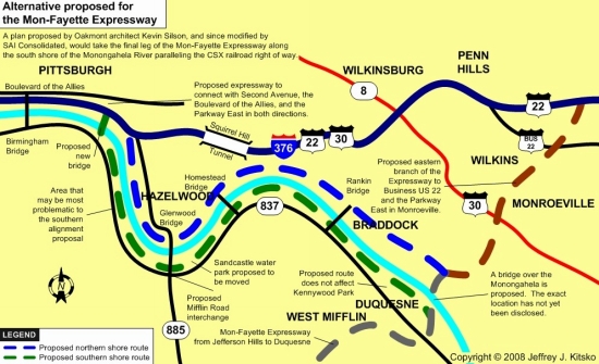
(James Hilston/Pittsburgh Post-Gazette)

Proposed
Glenwood Bridge interchange, looking northeast.
(Pennsylvania Turnpike Commission)

North Shore
Alternative near the Carrie Furnace site, looking northeast.
(Pennsylvania Turnpike Commission)

View of the
expressway from the Homestead High-Level Bridge, across from
the Homestead Waterfront. (Pennsylvania Turnpike Commission)

Looking
northeast at the Westinghouse Bridge in East Pittsburgh.
(Pennsylvania Turnpike Commission)

Looking
northwest in Turtle Creek showing potential relocation of Penn
Plaza.
(Pennsylvania Turnpike Commission)
Jefferson
Hills:
Alternate
alignments that would carry the highway either west or
east of the Clairton Sportsmen's Club property are still being
evaluated. Environmental impact studies, engineering issues
and costs were being addressed.
West
Mifflin:
As mentioned
above, no houses on Randall Street would be
demolished. The location of an interchange is being studies
because the original plan would have meant a two mile drive for
3,000 workers and hundreds of trucks from the highway to the
USX Irvin Plant and the GM Fisher Body Works.
Dravosburg:
The
plan is being evaluated so the highway will affect fewer of
the 40 homes in the Riverview Plan that were slated for
demolition.
Duquense:
The
PTC is considering building a grade-separated access ramp
to Duquesne City Center, a new development on former steel
plant property. A more simplified connection with PA 837 and
Commonwealth Avenue is being evaluated.
East
Pittsburgh:
No major
issues.
North
Versailles:
Engineering
continues on an interchange that would connect US
30 and the Tri-Boro Expressway in the East McKeesport area.
The East McKeesport-East Pittsburgh Boulevard Bridge, which
was to be demolished, will now be utilized.
Turtle
Creek:
The
problem has been how to preserve the Penn Plaza shopping
center and the number of churches and historical properties. One,
for example, is the Greensburg Pike Bridge that was to be
replaced is now expected to survive.
Wilkins:
As mentioned
above, a new site must be found for the CompUSA
store. The PTC is looking at a "development pad" to be
established behind the Sears store in Penn Center.
Monroeville:
No major
issues.
Penn
Hills:
There
are plans to build a ramp that would access the last
acreage with developmental potential. It would be up to the
municipality to connect the ramp to the rest of the
community.
North
Braddock:
No major
issues.
Braddock:
Talks
with the railroads about relocating track is still in the works.
An interchange would be located near Sixth Street.
Rankin:
The
PTC is trying to meet officials' request to connect Turnpike 43
with the Park Corp. property. It is a redevelopment site on the north
shore of the Monongahela River.
Swissvale:
No major
issues.
Pittsburgh:
Mayor
Murphy has all but given the green light to commence
building on the North Shore alignment. The PTC is trying to abide
to conditions set by his honor. They include:
1. Minimizing residential displacement in Hazelwood.
2. Providing access to the Boulevard of the Allies.
3. Minimize impact on Irvine Street, Second Avenue, and the
Parkway.
In the meantime, engineers are studying plans on crossing the
Mon back to the south bank, opposite Glenwood. A new bridge
or the possibly the Birmingham Bridge would be used to connect
into the city.
There are
many routes being considered for this leg of the highway. They
include a route through Brownsville's Northside Historic District utilizing
the existing Lane Bane Bridge, which would be widened, and a 1,000 foot "cut
and cover" tunnel; a southern Brownsville option through Centerville
Borough and Luzerne Township; and a northern Brownsville proposal near
California. The points of connection for this section to the existing
highway will either be with PA Turnpike 43 near California or PA
88 near Centerville. The southern connection with US 119 will
either be at PA 51 in North Union Township or PA 21 in South Union
Township.

Rand McNally "jumped the gun" in the
1992 edition of the road atlas by
indicating this section as "under
construction." Also, it is indicated as
a free highway. (Rand McNally)
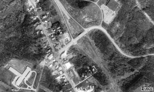
The end of the US 40 expressway east of Brownsville.
Under the
Brownsville-Uniontown plan, this section will
finally be built and connect
to the new expressway. (USGS)
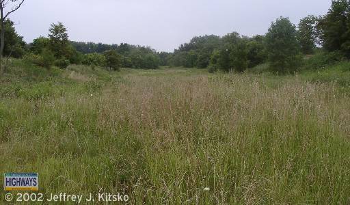
Looking eastbound down the future right-of-way of the US 40
connector to
the Mon-Fayette Expressway.
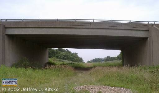
Looking westbound towards the stub-end of the US 40 expressway out
of
Brownsville. This will be finished when the Brownsville
to Uniontown
section of PA Turnpike 43 is finished.
 INFORMATION
Southern
Terminus:West Virginia state line east
of Lake Lynn.
Northern
Terminus:I-376 in Pittsburgh.
Lengths:
12 miles (Fayette County)
24 miles (Washington and Allegheny Counties)
Completed length: 70 miles
National
Highway
System:Entire length
Names:
Mon-Fayette Expressway
James J. Manderino Memorial
Highway: Exit 30 to Exit 36
J. Barry Stout Expressway: Exit 36 to the Allegheny County line
Medal of Honor Highway: PA 51 to I-376 in Pittsburgh
James J. Manderino Highway: Exit 30 to Exit 36
SR
Designation:SR 7043
Counties:
Fayette, Washington, and
Allegheny
Multiplexed
Routes:None
Former
Designations:PA 88 (1984 - 1990):
Exit 32 to Exit 34
PA Toll 43 (1990 - 2000)
Speed Limits:
See exit guide
Emergency:
*11 and call boxes every
mile
Highway
Conditions:1-800-331-3414/717-939-9871
Area Codes:
724/878: West Virginia
state line to the Allegheny County line
412/878: Allegheny County line to Pittsburgh
Back to Pennsylvania Highways
Back to Pennsylvania Toll
Highways
Page updated March 23, 2004.
Content and graphics, unless otherwise noted, copyright © Jeffrey J. Kitsko. All rights reserved.
Information sign courtesy of Richard C. Moeur.
Pennsylvania shield courtesy of James Lin.
Information courtesy of the Pennsylvania Turnpike Commission, the Pennsylvania
Turnpike Traveler, Directions: Newsletter for PTC Employees
Spring 2003 issue, Fayette Expressway
Completion Organization,
Greensburg Tribune-Review, Pittsburgh Post-Gazette, and the Pittsburgh Press.


