Veterans Memorial Highway
Pennsylvania Turnpike Northeast Extension
Veterans Memorial Highway
Pennsylvania Turnpike Northeast Extension
One of the last Interstates to be completed in Pennsylvania, which is ironic since it had been proposed since 1929. The purpose of the highway was to create a better route from Chester to the Norristown area. In 1932, the Regional Planning Federation, the forerunner to today's Delaware Valley Regional Planning Commission, proposed a New York City-like parkway along the current right-of-way, complete with stone-arch bridges and natural landscaping. However, the plan fell through, and no expressway was built.
Initially, this project was under the guidance of the Pennsylvania Turnpike Commission, which incorporated the 1929 plan. In the early 1950s, before the Interstate Act was passed, the state proposed a system of limited access toll highways that followed the routes of the current Interstates. I-476, or the Chester Extension as the Turnpike Commission referred to it as, was projected to be constructed as one of these toll routes. The highway would start near Chester and connect with the Turnpike at the Northeast Extension Interchange.
In 1956, the Federal Highway Act was signed into law by President Eisenhower, and brought the PTC's grandiose plans to a grinding halt. Construction of the Mid-County Expressway would now be the job of the Pennsylvania Department of Highways. They devised three routes for the expressway through Delaware and Montgomery Counties:
As the years wore on, protesting and not construction seemed to be the norm for the expressway. It was not for fear of taking houses, which the Blue Route was routed to take fewer than the other proposals, but that the expressway would disrupt the Darby Creek and Crum Creek valleys. By 1964, dust was not rising from the project but the cost was, and topping out at $78 million by 1964. In 1970, two sections opened: a two and a half mile section through Broomall and Bryn Mawr and another mile and a half section through Radnor. It was a case of "two steps forward, one step back" as neither section connected to any highways or streets and both would sit devoid of traffic for nearly two decades.
The Department of Highway's maps from the mid-1960s showed the route with the words "OPEN MID 1970" and so on until 1972. Then it was dropped to just show the route when it was apparent that the highway was not going to be completed and for good reason. By the 1970s, new Federal and state environmental regulations gave the opponents of the Mid-County Expressway new ammunition. Between 1970 and 1972, environmental impact studies were performed as a new part of the process of Interstate construction. Previous studies were made null and void under the new laws, and therefore the entire 21.5-mile length of the Blue Route had to be re-evaluated. Although, construction still continued on the interchanges at Interstate 76 and Interstate 95 since they were already under contract.
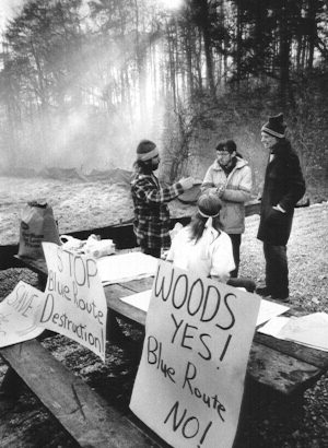
One of many protests against I-476.
(Philadelphia Inquirer)
Between 1976 and 1978, PENNDOT conducted public hearings on the draft and final environmental impact statements. The expressway would feature six lanes and have interchanges at US 1, PA 3, US 30, and a partial one at PA 320. Originally interchanges would have also been constructed for the Lansdowne Expressway near milemarker seven and the Radnor Spur of US 422 in Radnor Township, but those expressways were cancelled in 1977 by PENNDOT. Lost in all the protesting and hearings, the first section of the Blue Route from from I-76 to Exit 19 managed to open in 1979.
Word came down in March 1979 from the Federal Highway Administration that it would not accept the final environmental impact statements unless PENNDOT spelled out the number of lanes and interchanges, PENNDOT's financial standing, and how SEPTA mass transit could interface with the Interstate. A task force was organized by the Department of Transportation to study these issues and devise a revised environmental statement. The results were submitted to the FHWA in May 1980, and in August of that year they approved the plans. The celebration would be short lived when in November 1981, the Townships of Marple, Radnor, Ashwood Manor and Swarthmore with the Citizens Council of Delaware County won an injunction to stop construction in US District Court.
PENNDOT would not be denied their Interstate, and drafted two new environmental impact statements for the missing links in 1983. The expressway would be four-lanes south of PA 3 and six-lanes north of that interchange, with both sections featuring 12-foot-wide lanes, 10-foot-wide shoulders, variable medians, and a 65 MPH design speed. The section south of PA 3 would be a parkway-like highway, less evasive right-of-way acquisitions in respect to residences, parklands, and historic sites. Sound walls with pockets to allow vegetation to grow and therefore blend in with the surroundings were installed. From Ridge Pike to the Turnpike, the expressway would be six lanes and tie into Interstate 276 with a massive interchange comprising a 17-lane toll plaza, seven bridges, and 4.4 miles of ramps. The statements for each section also provided for park-and-ride lots for four intersecting commuter rail lines, which was something noticeably missing from the original 1950s plans.
Opposition to the expressway kept most of the project in legal battles, mainly with PENNDOT being the object of law suits over wetland protection issues. It wasn't until 1985 when a Federal judge dismissed the suits and gave the go-ahead for construction provided PENNDOT monitored environmental impacts during construction. In that same year, construction resumed on the section between Interstate 95 and MacDade Boulevard. That section opened in 1987 and cost $28 million to build, but was signed more or less as an interchange without any mention of I-476.
Finally on December 19, 1991, after all the protesting, arguing, and suing, the section of Interstate 476 from MacDade Boulevard to the Schuylkill Expressway opened to traffic. The remaining section from Ridge Pike to Germantown Pike opened almost a year later on December 16, 1992. The cost of the highway was tallied at $600 million, or $5,503 a foot. A significant difference from the original proposed cost in 1957 of $40 million. This Interstate joined I-279 in Pittsburgh, I-78 in Allentown-Bethlehem, and I-676 in Philadelphia as one of the last legs of the Pennsylvania Interstate System to be completed.
The Turnpike section of this Interstate did not encounter as many problems getting off the ground. Ground was broken on March 25, 1954 for the spur to Scranton, which had been authorized as early as 1947.
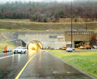
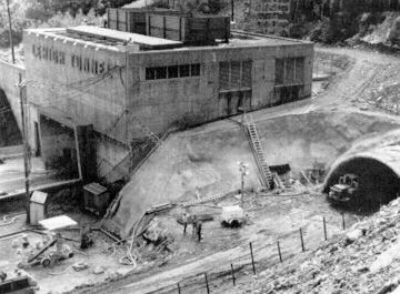
The first section of the Northeast Extension opened on November 23, 1955. Its initial 37 miles opened from a interchange east of the Norristown interchange to the Lehigh Valley interchange. Interchanges at Lansdale and Quakertown opened later on December 3 and December 10, respectively. From the Lehigh Valley interchange, another 10 miles opened to a temporary interchange at Emerald on December 28, 1955. Work was still taking place to build the two-lane, 4,461 foot long tunnel through Blue Mountain. It was named Lehigh Tunnel so as not to be confused with the tunnel through the same mountain on the main line Turnpike.
On April 1, 1957, the Northeast Extension was opened to the Wyoming Valley interchange near Wilkes-Barre. At this time, the temporary interchange at Emerald closed. The last 16 miles to Scranton opened on November 7, 1957. With the opening, it brought the Northeast Extension's total length to 110 miles, and the total system length to 470 miles.
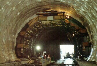
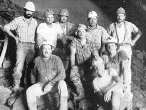
Since the popularity of the Poconos had increased, so did the traffic that resulted in 22,000 vehicles a day during August: the busiest time of the year. In 1988, a contract to widen the Lehigh Tunnel on the Northeast Extension was awarded for $37 million. On February 14, 1989 (coincidentally my 12th birthday), ground was broken on the second tunnel. A new method to constructing this tunnel was implemented. The other tunnels were constructed by blasting rock loose, then clearing the debris and erecting a steel superstructure inside the tunnel. This was repeated many times until the tunnel was completed. This new technique is called the New Austrian Tunnel Method (NATM), and this was the first highway project in the United States to use NATM. It has been used in Europe since the 1950s, it had been utilized in two light rail projects: the Mount Washington Tunnel in Pittsburgh and Washington Metro system. With the technique, after each blasting of rock, the ceiling and sides are stabilized by being sprayed by shotcrete. The 4,380-foot-long tunnel was bored 94 feet west of the existing tube and was "holed through" on June 12, 1990. The men, working three shifts, 24 hours a day, six days a week had tunneled 3,550 feet through the north side of the Blue Mountain and and 675 feet through the south side.
Two American contracting firms and one Nova Scotian firm handled the construction. Pennsylvania designers of the new tunnel are the engineering firms of GSGSB of Clarks Summit, and McCormick, Taylor and Associates of Philadelphia. Two tunneling consultants, Dr. Gerhardt Sauer Company of Herndon, VA, specialists in the NATM technique, and Michael Baker Jr., Inc. of Pittsburgh, engineering consultants to the Turnpike Commission also worked on the project.
The new tunnel opened to traffic in November 1991, and eliminated the last two lane section of the Turnpike. When it opened, the original tube was closed for refurbishing. This would eliminate the last section of two lane roadway on the system.
|
|
|
|
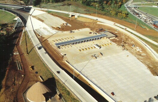
In late 1989, ground was broken on the Mid-County Interchange in Plymouth Township, Montgomery County. This project included the largest contract awarded by the Pennsylvania Turnpike Commission. The interchange is the largest in the system and the first additional interchange on the mainline to be constructed since completion of the Scranton Interchange on the Northeast Extension in 1957. The interchange has the largest toll plaza with 17 lanes for entering and exiting traffic and eight ramps comprising 4.4 miles. The Mid-County and Norristown interchanges are connected via a fiber optic cable which permits data sharing between the toll plazas and the main office in Harrisburg.
A $55 million general construction contract was awarded to the Hull Corporation of Syracuse, New York in late 1989. This included construction of the toll plaza, utility building, roadway, structures, signing, and lighting.
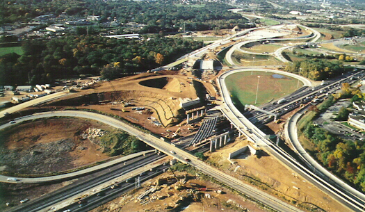
Mid-County Interchange under construction. The old Northeast Extension
interchange bridge
is in the foreground. (Pennsylvania Turnpike Commission)
In 1990, the PTC awarded contracts totaling $131,000 to the Hull Corporation for heating, ventilation, and air conditioning. Thomas M. Durkin and Sons' contracted to handle wetland replacement totaling $316,097.
|
|
|
|
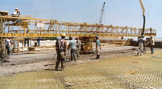
Since the construction took place in a highly developed area of suburban Philadelphia where there are many active roadways, maintaining a smooth traffic flow posed a challenge. To prevent problems, the project was divided into phases and stages. The purposes of this was to maintain at least four lanes of traffic on the mainline Turnpike and to provide access to the Northeast Extension while the ramps are under construction. Solution cavities posed an even greater problem to the construction. These are formed when groundwater has worn away earth between limestone rocks, thus creating an underground cavern. To guarantee that the bridge supports at the south end of the culvert for the Plymouth Creek sat on firm ground, an addition $400,000 was needed. This paid for extra excavation and concrete work. A concrete grout mixture was pumped underneath and around the bottom of the bridge pilings required an additional $350,000. On December 15, 1992, the first interchange on the Turnpike to have "fly over" ramps opened.
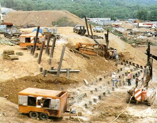
Grout being pumped into underground voids.
(Pennsylvania Turnpike Commission)
This would not be the last interchange to be added. The Keyser Avenue interchange was added in the early 1990s. Construction began in February 1991 on the interchange that served as the final exit on the Northeast Extension while the Wyoming Valley mainline toll barrier was built and the Scranton Interchange underwent reconstruction. The interchange was designed by Gannett Flemming, Inc. of Camp Hill and American Asphalt Paving of Shavertown performed the construction. Wyoming Sand and Stone supplied materials for the project. The interchange completely opened in 1992 and completed Interstate 476.
As mentioned above, work also began on the mainline north of the Wyoming Valley interchange. An $11 million project began on March 19, 1991 with the demolition of the old Wyoming Valley interchange and construction of a seven lane mainline barrier two and a quarter miles south. This is now where the ticket system ends, because from that point north the highway is a coin drop system as on the toll highways in Southwest Pennsylvania. In November 1992, this section of the Turnpike reopened to traffic.
In 1996, the Turnpike Commission lobbied to have the Interstate 476 designation extended up the Northeast Extension to Scranton. The official designation change occurred on November 1, 1996. Prior to that, the section from Exit 20 to Exit 131 was designated as PA 9. So as not to confuse travelers, and to mark every section of the Turnpike as I-76 or an I-x76, the Federal Highway Administration granted the designation change.
In January 1999, the PTC began a feasibility study on widening the highway from the Mid-County to Lansdale Interchanges. The entire project , including widening work on the mainline from Valley Forge to Norristown, will cost approximately $200 million. The project on the Northeast Extension is a little more complicated since the existing median is only four feet wide. Urban engineers will be brought in to design a plan for the ten mile section from Mid-County to Lansdale, which includes a slip ramp south of the Lansdale interchange.
E-ZPass, an electronic toll collection system, was unveiled on December 2, 2000 between Exits 20 and 56 and then extended to the Wyoming Valley Toll Barrier on May 19, 2001. Commercial vehicles were allowed to use it for the first time on December 14, 2002. This system is, or will be, used for toll collection on every toll highway and bridge in the Northeast.
December 28, 2001 was not a good day to be on Interstate 476 as several multiple-vehicle accidents caused by snow squalls shut down the highway late that afternoon south of Wilkes-Barre. There were no injuries reported from the crashes, which occurred between Exit 95 and Exit 115.
 PENNDOT Emergency Routing Maps Montgomery County I-476 Emergency Detours |
Links:
Exit Guide
Interstate 476 Pictures
Interstate 476 Ramp Meter System
Interstate 480
PA 9
Pennsylvania
Turnpike
E-ZPass
- Pennsylvania Turnpike Commission
Pennsylvania Turnpike Commission
Pennsylvania
Turnpike Fare Schedule for Exits 122 and 131
Pennsylvania
Turnpike Toll/Mileage Calculator - Pennsylvania Turnpike Commission
Interstate 476 - Andy Field/Alex Nitzman
Interstate 476 - Scott Kozel
Interstate 476 - Scott Oglesby
Interstate
476 Pictures - Andy Field/Alex Nitzman
Lehigh Tunnel
- Alex Nitzman
Mid-County Expressway-Blue Route - Steve Anderson
Pennsylvania Turnpike-Northeast Extension - Steve Anderson
 INFORMATION |
|
| Southern Terminus: |
I-95 at Exit 7 in Chester. |
| Northern Terminus: |
I-81/US 6/US 11 in Scranton. |
| Length: | 131 miles |
| National Highway System: |
Entire length |
| Names: | Blue Route: I-95 to Exit 20 Veterans Memorial Highway: I-95 to Exit 20 Pennsylvania Turnpike Northeast Extension: Exit 20 to Exit 131 Mid-County Expressway: I-95 to Exit 20 |
| SR Designations: |
SR 0476: I-95 to I-276 SR 7476: I-276 to I-81 |
| Counties: | Delaware, Montgomery, Bucks, Lehigh, Carbon, Luzerne, and Lackawanna |
| Multiplexed Routes: |
None |
| Former Designations: |
I-495 (1958 - 1960): I-95 to Exit 20 I-480 (1960 - 1963): I-95 to Exit 20 PA 9 (1974 - 1996): Exit 20 to Exit 131 |
| Speed Limits: | See exit guide |
| Emergency: | 911 (Interstate) *11 and call boxes every mile (Turnpike) |
 Highway Conditions: |
Interstate
476 Conditions - Veterans Memorial Highway
|
 Highway Conditions: |
http://www.paturnpike.com/rttc/ 1-800-331-3414/717-939-9871 - Northeast Extension |
 Traffic Conditions: |
I-95 - PA Turnpike/I-276 PA Turnpike/I-276 - Quakertown #211/215-567-5678 |
| Travel Radio: | 1640 |
| Area Codes: | 610/484/835: I-95 to
Allentown 570: Allentown to I-81 |