Penn-Lincoln Parkway East
Penn-Lincoln Parkway East
Back in the late 1940s, as the steel industry was heating up in Pittsburgh, it was determined that something had to be done for transportation into and out of the city. Called to help with the planning of the "new Pittsburgh" was Robert Moses, known for helping to shape New York City's highway transportation network, devised a plan that included the Crosstown Boulevard as well as the Penn-Lincoln Parkway.
|
|
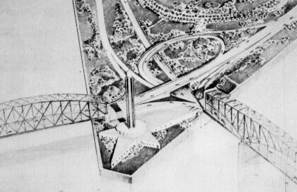
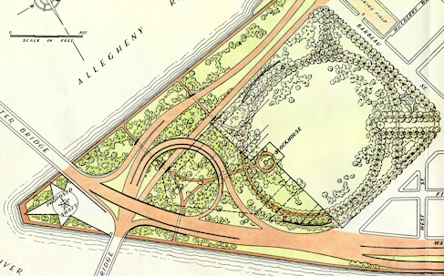 Detailed drawing of the interchange at the Point. (Arterial Plan for Pittsburgh) |
|
|
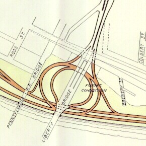 Drawing of the proposed interchange between the Pitt Parkway and Crosstown Boulevard. (Arterial Plan for Pittsburgh) |
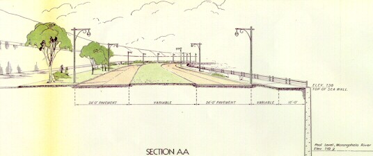 Cross section of what the Pitt Parkway would have looked like. (Arterial Plan for Pittsburgh) |
Cross sections of the Pitt Parkway (.PDF) - Arterial Plan for Pittsburgh
The Department of Highways proposed a parkway from US 22 in Churchill to downtown and out to the new Greater Pittsburgh International Airport in May 1944, to be called the Pitt Parkway after Moses' suggestion. However, unlike his plan, the Parkway would not have at-grade intersections at certain areas, and the name changed to reflect the confluence of the two highways that would be carried: William Penn and Lincoln. Most of alignment that was proposed was used in the final design and construction; however, the one section that was under debate was from the Edgewood-Swissvale area to downtown. The three routes that were studied were the Penn Avenue Alternate, Fifth Avenue Alternate, and the adopted location. The specifics of the routes were as follow:
Specs for the Squirrel Hill Tunnel (.PDF) - Pennsylvania Department of Highways
| Penn-Lincoln Parkway Designs from 1952 | |
| Picture | Source |
| Proposed Parkway East and Fort Pitt Bridge | Paul Slantis |
| Proposed Boulevard of the Allies Interchange | |
Ground was broken on July 25, 1946 when Alexander Alden of West Pittsburgh, Pennsylvania climbed aboard a Caterpillar D-8 and commenced bulldozing from Greensburg Pike to Ardmore Boulevard in Wilkinsburg. The sound of timber crashing to the ground signaled the start of a transportation revolution in the Steel City. Johnson, Drake, and Piper, Inc. of New York was the general contractor, having submitted a low bid of $2,042,368. The excavation and grading working was completed by the M & S Construction Company, Inc. of Pittsburgh.
| Penn-Lincoln Parkway Construction | |
| Picture | Source |
| Parkway East and Fort Pitt Bridge Interchange in 1957 | Pennsylvania Department of Highways |
| Retaining wall near Duquesne University in September 1953 | James Blair |
| End of the Parkway at Bates Street on March 12, 1953 | Pennsylvania Department of Highways |
| Looking west from Brady Street on April 13, 1954 | |
| Parkway at Brady Street in September 1953 | James Blair |
| Construction at the Bates Street Interchange in 1950 | Pennsylvania Department of Highways |
| Construction at Forward Avenue in June 1952 | Clyde Hare |
| Pneumatic placers used to place the Squirrel Hill Tunnel lining | Pennsylvania Department of Highways |
| Assembling steel forms for the concrete tunnel lining in 1953 | |
One of the more challenging aspects of the project was what to do with Squirrel Hill which sat in the path of the expressway. Excavating a cut would destroy the neighborhood above, so a tunnel was proposed as the solution. On August 5, 1948, the Department of Highways announced that construction of the 4,200-foot-long Squirrel Hill Tunnel would begin by September 1. This would become the department's largest contract ever awarded to that time, totaling $13,767,843 went to B. Perini & Sons, Inc. of Framingham, Massachusetts. This did not include construction of the tunnel lining and highway surface inside the tunnel, nor the ventilating building or pavement of the approaches. The tunnel project experienced a delay in March 1948, due to the lowest bid placed at that time at $18 million, an offer that was promptly turned down by the state. That bid called for complete construction, but the Department of Highways saw no need to include items like the lining and roadway surface while material costs were high following World War II.
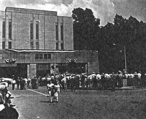 Opening ceremonies for the Squirrel Hill Tunnel on June 5, 1953. (Clyde Hare) |
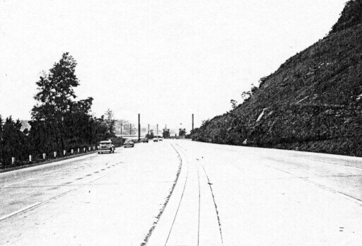 Westbound heading towards Bates Street in August 1953. (Harold Corsini) |
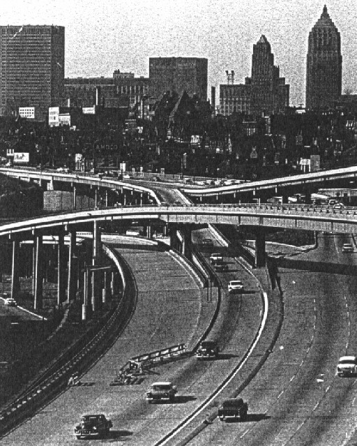 Temporary end of the Penn-Lincoln Parkway at the Boulevard of the Allies in 1959. (Clyde Hare) |
The first section, from Exit 2B to Exit 10B opened on June 5, 1953. It was also a tricky project, which involved practically blasting into the basements of some buildings. About 400,000 cubic feet of earth was moved in the construction. The last section to open was from the Point to Exit 2B in 1959. The reason for the delay was that it was necessary to move the Baltimore & Ohio Railroad buildings and track near the Grant Street interchange. Also, weaving the highway in between the elevated eastbound lanes of Fort Pitt Boulevard took time.
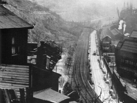
View along Second Avenue in 1948. The hillside is currently
where I-376 runs. (Todd Webb)
The final link was from Churchill to the Turnpike which began in 1961. Not just because of I-70 being proposed through the city, but also because of the growth of Monroeville, a bypass had to be built. That section opened in 1962. It is easy to tell that this part was built after the Interstate legislation was passed because of the wide median and it is six lanes.
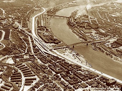
View of the Parkway at the Boulevard of the Allies
interchange in 1958.
(Pennsylvania Department of Highways)
In the mid-1980s, the original Parkway was beginning to show its wear. PENNDOT rebuilt the entire highway, from ground up, from the Greensburg Pike interchange into downtown which equated to 6.7 miles of the highway. For a time, the westbound lanes were closed, which meant the eastbound lanes were used for two way traffic. The project included rehabilitating 21 bridges including the Squirrel Hill Tunnels and required 200,000 square yards of slip-formed reinforced concrete. This project ended in late 1985. One feature of the project was the addition of pumps in the westbound lanes between I-279 and Exit 1C. These lanes are depressed and on the same level as the Mon Warf parking area and the Monongahela River. During floods such as in 1972 when Tropical Storm Agnes hit Pennsylvania, the parking area is always under water. If water reaches the highway, the pumps kick on.
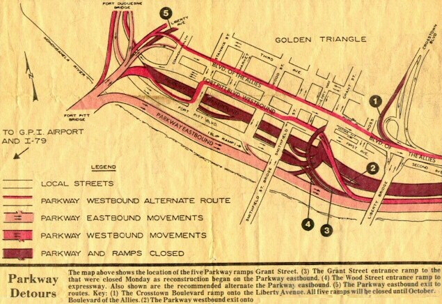
I-376 detours during the construction. (Greensburg Tribune-Review)
In the late 1980s, time also began to take its toll on the Greenfield Bridge. This is the bridge over the Parkway on the western side of the Squirrel Hill Tunnel. One day, large chunks of concrete began to fall onto the Parkway. Many cars were damaged; fortunately, not many people were injured. PENNDOT's response to this was to string large nets around the supports of the bridge, which are are still there today.
As mentioned above, the westbound lanes of the Parkway from Stanwix Street to Grant Street are located on the same level as the Monongahela River. Between January 19 and 21, 1996, these lanes were closed down because of flooding. The rare January thaw due to temperatures into the 60s caused tremendous run-off from melting snow flooded many low lying areas including the Point.
Out of all of the people driving the Parkway on October 25, 2000, Anisa Hadiya Abdul is a unique commuter. The reason being is that came into the world just a little after midnight on that day right at the Oakland interchange. Aleeshea Cosby, mother, was leaving her job at University of Pittsburgh Medical Center and was heading home. She began having pains, but did not think anything of it since she was due on November 17. Aleeshea called a friend, Sylvia White, to tell her she was going to the hospital and she might need her as a backup driver. Good thing, because her services were needed. Sylvia entered the Squirrel Hill Tunnels driving with a mother-to-be and exited with a woman in labor. White managed to pull over and to wait for city paramedics; however, little Anisa was not so patient. The 6-pound, 12-ounce baby girl measuring 18 1/2 inches long and in perfect health came before the paramedics could get to the scene.
If you were traveling the Parkways on January 11, 2001, you have my sympathy. On that day, not one but two trucks ended up getting lodged in both the Squirrel Hill and Fort Pitt Tunnels and during both rush hours. This is not the first time a truck has become wedged in either tunnel as it has happened many times over the years; however, it was the first time where it happened twice on the same day. The incident on the Parkway East started when an Ontario truck driver got his tractor trailer stuck in the Squirrel Hill Tunnel at 3:45 PM. The driver assumed that his rig would fit through the tunnel since the overheight truck warning signals did not flash, which were shut off due to mechanical problems. However, Officer Ramon Paul of the Pennsylvania State Police said that his truck was actually 14 feet, 4 inches; 10 inches too tall. At about 100 feet into the tunnel, the trailer became wedged against the ceiling. The driver then proceeded to back the vehicle out which added to the problems when the drive shaft broke. The first attempt to dislodge the trailer by letting the air out of the tires worked, but the trailer could only be pulled by a tow truck inches at a time. The second attempt did the trick when the towing company first pulled the trailer off the tractor and then both out shortly after 7:00 PM. By 7:20 PM, the line of vehicles that stretched all the way to Monroeville were finally moving once again.

The stuck truck sitting just inside the tunnel entrance.
(WTAE-TV)
Another unfortunate incident happened on January 28, 2001 when a tour bus heading from Steubenville, Ohio en route to the Seven Springs ski resort flipped over as it turned to head toward the Turnpike's toll plaza. Only a few were injured which was surprising because the bus slid off the highway into a wooded area off the shoulder.
The exit renumbering that took place on I-376 in the summer of 2000 was not the first for one segment of the expressway. In 1964, when the designation changed from I-70 to I-76 from the Point to the Turnpike, so did the exit numbers to commence the numbering sequence. The numbers began with Exit 22 at Stanwix Street and ended with Exit 37 at Murrysville, and afterwards Stanwix Street became Exit 1 and Murrysville became Exit 17. This sequence continued after the designation changed to I-376 in 1972.
With a highway as old as the Parkway, problems usually arise. One such problem is the cracking and shifting of a concrete retaining wall that supports the expressway's eastbound side between the Boulevard of the Allies and Bates Street. Fred Reginella, City Director of Engineering and Construction, who toured the site with PENNDOT engineers in December 2001 said, "It's alarming." PENNDOT District 11 Engineer Ray Hack said, "We've been monitoring the wall since summer and it's moving faster than we'd like." As a result, Hack asked the Department of Transportation administrators in Harrisburg to authorize $350,000 in extra funds for emergency repairs, and the request was granted. The 150 foot-long section was discovered in summer 2001 by PENNDOT maintenance workers who noticed minor subsidence on the shoulder and slight shifts to the Jersey barrier that runs along the side of the expressway. From below the evidence is more convincing, as large pieces of concrete now lay on the ground next to the base of the wall. The contractor in charge of the repairs will drill through the wall and insert large bolts into the earth, known as "rock anchors" which might mean the closure of the far right lane at times. Hack also mentioned that the northern terminus of the Mon-Fayette Expressway is proposed to connect to the Parkway near this area, and that the Pennsylvania Turnpike Commission would be responsible for construction of a new wall.
One problem that was facing the City of Pittsburgh was that eastbound lanes of Fort Pitt Boulevard were crumbling. It was so bad that you could see exposed rebar driving along the highway. Also, due to years of use, the lanes began to sink forming sunken areas where water would pond in heavy rains. One of the only places where an elevated highway would flood. Because of the decrepit nature of the eastbound lanes, a detour was put in place for vehicles weighting more than eight tons. Traffic was also a problem on the Boulevard, because it was the only connection from I-279 south to I-376 east. A proposal to rebuild the eastbound lanes and to construct a direct connection to I-376 east was arranged. The project began in early 2002 with the demolition of the elevated lanes. The Interstate Connector opened on December 6, 2002 at 11 AM.
While the last leg of rehabilitation of the Fort Pitt Bridge and Tunnel were taking place, work was also performed on the segment of the Parkway from the bridge to Grant Street. Construction began on April 6 to replace the elevated section which spans the Mon Wharf Parking Lot, and the section under the Smithfield Street Bridge. This section reopened to traffic on October 1, 2003.
More flooding affected the Parkway from Stanwix Street to Grant Street on November 20, 2003. The rising water was caused by a heavy line of rain showers that blanketed western Pennsylvania a day earlier. The closure of the lanes at evening rush hour caused gridlock in downtown Pittsburgh, with back-ups stretching all the way out to the Edgewood/Swissvale interchange. The lanes reopened to traffic on November 21.
Links:
Exit Guide
Interstate 376 Pictures
Interstate 70
Interstate 76
I-376 Parkway East
Traffic Camera - WTAE-TV
Field Notes-Squirrel Hill Tunnel and Penn Lincoln Parkway East - Bruce
Cridlebaugh
Fort Pitt Boulevard - Bruce Cridlebaugh
The
I-279/376 Downtown Connector - Adam Prince
Interstate 376 - Andy Field/Alex Nitzman
Interstate 376 - Scott
Oglesby
Interstate
376 Pictures - Andy Field/Alex Nitzman
Interstate
376 Pictures (Allegheny County) - Doug Kerr
Interstate
376 Pictures (City of Pittsburgh) - Doug Kerr
Penn-Lincoln
Parkway East Structure Tour - Bruce Cridlebaugh
Squirrel
Hill Tunnel - Bruce Cridlebaugh
 INFORMATION |
|
| Western Terminus: |
I-279 at Exit 6A in Pittsburgh. |
| Eastern Terminus: |
I-76 at Exit 57 in Monroeville. |
| Length: | 15 miles |
| National Highway System: |
Entire length |
| Names: | Penn-Lincoln Parkway Parkway Central: I-279 to Exit 2A Parkway East: Exit 2A to Turnpike |
| SR Designation: |
SR 0376 |
| County: | Allegheny |
| Multiplexed Routes: |
US 22: I-279
in Pittsburgh to Monroeville. US 30: I-279 in Pittsburgh to Exit 8A in Wilkinsburg. |
| Former Designations: |
PA 80 (1951 - 1961): Exit 8B to Exit 10B I-70 (1960 - 1963) I-76 (1963 - 1974) |
| Speed Limits: | See exit guide |
| Emergency: | 911 |
 Highway Conditions: |
Interstate 376 Conditions |
 Traffic Conditions: |
Monroeville -
downtown (Westbound) Downtown - Monroeville (Eastbound) Churchill - downtown (Westbound) |
Traffic Cameras: |
Commonwealth
Place (Westbound) Ft. Pitt Boulevard (Westbound) Grant Street (Eastbound) County Jail (Eastbound) Birmingham Bridge/Bates Street (Eastbound) Bates Street (Westbound) Swinburne Street (Eastbound) Saline Street (Westbound) Beechwood Boulevard (Eastbound) Commercial Street (Westbound) Swissvale (Eastbound) Edgewood (Westbound) Brinton Road (Westbound) Forest Hills (Westbound) Wilkinsburg (Eastbound) Greensburg Pike (Westbound) Chruchill (Eastbound) Penn Hills (Eastbound) |
| Travel Radio: | 1620 |
| Area Codes: | 412/878 |

.focus)
.focus)
.focus)
.focus)
.focus)
.focus)
.focus)
.focus)
.focus)
.focus)
.focus)