
Penn-Lincoln Parkway West
Raymond E. Wilt Memorial Highway
Penn-Lincoln Parkway West
Raymond E. Wilt Memorial Highway
Affectionately called the Parkway West and Parkway North, this Interstate is part of the Penn-Lincoln Parkway which was proposed in May 1944. It was a part of a plan to revitalize Pittsburgh, which included revamping the area at the Point and the construction of the Crosstown Boulevard. The plan was devised by Robert Moses, who was known for planning New York City's highway transportation system.
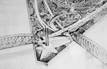
Moses' planned Point Interchange utilizing
the former Point
and Manchester Bridges. Instead
of the fountain, a beacon
was to be the center of focus at the point. I think the fountain
was a good choice. (Robert Moses)
| Penn-Lincoln Parkway Designs from 1952 | |
| Picture | Photographer |
| Proposed Parkway West in Carnegie | Paul Slantis |
| Proposed Parkway West in Greentree | |
| Proposed Parkway West and New Tunnel | |
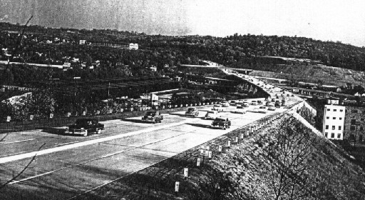
Construction began in the early 1950s with the first section opening from Exit 5C to out near the Pittsburgh International Airport in October 1951 with traffic using the West End Bypass to detour around the unfinished tunnel and bridge. On July 11, 1954 contracts for the initial design of the tunnels were awarded. The groundbreaking for the tunnel was held on April 17, 1957 with the drilling commencing on August 28, 1957. The price tag for the project would be $17 million. On March 31, 1958, Mayor David L. Lawrence and Governor George L. Leader pushed the button that triggered the blast to create an opening in the side of Mount Washington facing downtown Pittsburgh. The Fort Pitt Bridge opened May 1, 1959, which connected downtown to West Carson Street and replaced the old Point Bridge. The Fort Pitt Tunnels opened on September 1, 1960, completing the Penn-Lincoln Parkway from Monroeville to the Airport.
Specs for the Fort Pitt Bridge (.PDF) - Pennsylvania Department of Highways
| Penn-Lincoln Parkway Construction | |
| Picture | Photographer |
| Fort Pitt Bridge in 1958 | Paul Slantis |
| Northern Portal of the Fort Pitt Tunnel | |
| Southern Portal of the Fort Pitt Tunnel | Pennsylvania Department of Highways |
| Above Carnegie Facing West in 1951 | Clyde Hare |
|
|
|
|
|
|
Did you know that the double-rail barriers formerly on the Fort Pitt Bridge were actually installed backwards? You can still see an example of the backwards barrier on the Fort Duquesne Bridge, the Boulevard of the Allies, and the ramps around Point State Park. In 1962, a report was issued to have the railings installed with them facing inward to the highway which explains why I-579's look they way they do. This means that fewer truck accidents and payloads landing in Point State Park could have happened if the then Department of Highways would have re-bolted the brackets in response to the report.
Over the years, many designations have marked the current route of Interstate 279. Originally, from Interstate 79 to downtown, the I-70 designation was used until 1963. In 1963, the I-79 designation was extended from its former terminus at the Point to West Virginia. In 1972, the Interstate 76 designation was extended from the Point to Interstate 79. That same year, the I-279 designation was moved from the section of I-79 between its connections with I-279 north and west of the city to the current alignment to end at the Point. In 1973, the current route was created with the extension of the I-279 designation from downtown to I-79.

Temporary end of I-279 in Franklin Park in 1983. (USGS)
In the mid-1960s, construction began on the Fort Duquesne Bridge. There was a problem with the bridge as it did not connect to anything on the North Side until 1970, when ramps were built to Ridge Avenue. Since the bridge did not connect to anything on the North Shore, it was given the nickname "Bridge to Nowhere." One person found out what that exactly meant when they drove their car over the span and smashed into the bank of the Allegheny River.

Construction taking place on the Fort Duquesne Bridge.
(Pennsylvania Department of Highways)
In 1985, construction began on the long awaited Parkway North. The reason for the delay was having to move houses (and people) in the right-of-way. Also trying to wedge the eight-lane highway and two-lane East Street into a valley was a challenge. The remaining section from the Fort Duquesne Bridge to I-79 opened on September 16, 1989 at a cost of $550 million, 30 some years after being proposed. It has dedicated HOV lanes in the median in this section, which is a part of the Pittsburgh Busway System known as the North Hills Busway/North Hills Expressway HOV Lanes.

View of I-279 under construction in the East Street Valley in
February 1989. (Arthur G. Smith)
In 1995, a terrible crash happened on the HOV lanes. Two cars collided head on, because the outbound gates were not closed, which resulted in the deaths of six people. The PENNDOT employee responsible was convicted of murder.
The Fort Pitt Bridge and Tunnel rehabilitation project which was to begin in 1993, but was pushed back to the latter part of the 1990s due to fiscal problems, officially kicked off in 1997. The project that would bring Pittsburgh to a grinding halt began with the granite facade of the tunnel being replaced and a year later the ramps from Carson Street were rehabilitated.
On October 19, 1998, a truck jackknifed on the ramp from the I-376 to I-279 South. The driver lost control as he took the curve from the Parkway East to the Parkway West. The truck hit the left side of the ramp and the driver managed to steer the truck back onto the expressway. However, it then hit the right side and crashed through the bridge railing. The crash happened at 8:30 in the morning and took crews until 5:00 PM to clean up the area.
In that same month, a rental truck filled with items from a family that just moved to Pittsburgh tipped over on the bridge across Point State Park. All of the belongings spilled onto the park below. In December, a man who was stopped for DUI and speeding lost control and his car flew over the guide rail and landed in the park. It was quite a 1998 for Pittsburgh's Citiparks Department.
For those of you who hate losing the radio while you are going through a tunnel, you need to try the Fort Pitt Tunnels. In 1999, radio repeaters were installed through the tunnel so that motorists could receive FM and AM broadcasts. The system was developed by hometown institution, Carnegie Mellon University. A year later, an advanced overheight warning system was installed at the western portal.
Not one, but three reconstruction projects relating to the Fort Pitt Bridge and Tunnel rehabilitation project occurred in the last year of the 20th Century: the outbound 10th Street Bypass, Liberty Avenue, and the Portal Bridge. On April 29, 1999 the Portal Bridge was closed for reconstruction and reopened at midnight on June 23, 1999. The Portal Bridge lanes that carry traffic from the Fort Duquesne Bridge, 10th Street Bypass and Fort Duquesne Boulevard to the Fort Pitt Bridge reopened on July 28, 1999. August 1, 1999 the Liberty Avenue ramps closed and reopened 45 days later.

View of the Fort Pitt Bridge from the Monongahela River.
(Jeff Kitsko)
On March 15, 2000, the next step in the bridge and tunnel rehabilitation saw the Boulevard of the Allies off ramp closed for repairs. They reopened in Summer 2000. The next to be rebuilt was the inbound ramps to the Fort Duquesne Bridge, Tenth Street Bypass, and Fort Duquesne Boulevard. These reopened on November 17, 2000, in time for Pittsburgh's Light-Up Night. The the ramps from I-376 to the Fort Duquesne Bridge closed on August 14. Access to the Fort Duquesne Bridge from Commonwealth Place and Fort Pitt Boulevard was also shut down.
One of the strangest events to take place on a highway in Pittsburgh happened before dawn on April 17, 2000. Parts of the Interstate in the East Street Valley, and a few other highways, were doused with white, blue, yellow, red, and green paints. Officials with the Department of Transportation called it a random act of vandalism. PENNDOT believes some vehicles received splatter damage before tires spread it and it dried. In fact, one of the PENNDOT maintenance vehicles responding to the incident got paint on it as well.
A maintenance crew working the midnight shift spread absorbents and some sand on several of the spots. Dick Skrinjar, spokesman for PENNDOT, said that the crews also picked up a number of open one gallon paint cans and the cardboard boxes in which they were shipped.
He went on to say, "This is the time of year when we're repainting highway lines, and we don't need any help. This type of activity can lead to driver confusion and a serious accident. If the person or persons responsible are caught, we intend to prosecute to the full extent of the law. Our maintenance people said it looked like someone drove along and flipped the cans out the window and into the air. It was too random to be paint accidentally falling off the back of a truck. It was intentional."
If you were traveling the Parkways on January 11, 2001, you have my sympathy. On that day, not one but two trucks ended up getting lodged in both the Squirrel Hill and Fort Pitt Tunnels and during both rush hours. This is not the first time a truck has become wedged in either tunnel as it has happened many times over the years; however, it was the first time where it happened twice on the same day. The first incident involving trucks and tunnels occurred just before 7:00 AM in the Fort Pitt Tunnel when the air supply system on a tractor-trailer broke and locked up the brakes on the inbound truck. A 911 operator alerted tunnel crews to a supposedly overturned truck in the right lane. Workers arrived on the scene and soon had one of the two inbound lanes reopened. Not soon enough, as this resulted in a miles-long traffic jam stretching to the Interstate 79 interchange on the Parkway, and also causing delays on the alternate routes into the city.
PENNDOT spokesman Dick Skrinjar said that the truck "probably wouldn't have passed a Pennsylvania mechanical inspection. Our tunnel guys said that it was a piece of junk." The truck was then towed to an emergency pull-off near the Grant Street exit, complying with a PENNDOT policy regarding breakdowns in the tunnel or on interstate bridges around Point State Park. Even with the truck being towed out of the tunnel at 8:40 AM, traffic delays lasted for much of the morning.
The exit renumbering that took place on I-279 in the summer of 2000 was not the first for one segment of the expressway. In 1964, when the designation changed from I-70 to I-79 from the current I-79 interchange to the Point, so did the exit numbers to continue the numbering sequence. The numbers began with Exit 17 at Rosslyn Farms and ended with Exit 21 at US 19/PA 51, and afterwards Rosslyn Farms became Exit 16 and US 19/PA 51 became Exit 20. The remaining exits to the bridge were not numbered. When the Fort Duquesne Bridge opened, and I-279 was proposed to end at the Point, exit numbers were placed on that section beginning with Exit 1 at Liberty Avenue and Exit 4 for Three Rivers Stadium, now North Shore. In 1978, the entire route was renumbered to reflect the start of I-279 at I-79 west of Pittsburgh.
On April 6, 2002, the first severe impact of the project on I-279/US 22/US 30/Truck US 19 traffic was felt when the outbound bridge and tunnel were closed. The closing lasted until July 31, a full month earlier than what was projected. Almost a year later, on March 28, the inbound bridge and tunnel were closed, but the detours remained the same as the previous year's work. Inbound traffic would use the outbound lanes and outbound traffic would detour around the tunnel. On March 31, the Pittsburgh Tribune-Review did some feature pieces on the closure in addition to the following: Rehabilitating the Tunnel and Controlling the Tunnel. If you look on the bottom of both pages, you might notice a familiar source.
A fire broke out on May 16, 2003, while renovations were occurring on the inbound tunnel. The fire damaged or completely destroyed several construction vehicles such as a lift truck, a Bobcat loader, and four all-terrain vehicles that were in the tunnel and charred the tunnel face. The heat was so intense that it blackened and made the ceramic tiles on the face pop off the wall and melted bolts holding the aluminum letters that display the tunnel name. Four employees working in the tunnel control rooms at the time smelled then saw the smoke, and called the Pittsburgh Fire Bureau at 11:18 PM. Even though the fire did not spread to the outbound lanes, it did damage the electrical system, which meant that those lanes would not have lights, ventilation, or sensors to detect trucks too tall to enter the tunnel. The fire also knocked out a "muliplexer" where wires from the surveillance cameras along the Parkways are fed into a fiber-optic cable that sends the images to the PENNDOT traffic management center in Collier. Dick Skrinjar of PENNDOT said that 48 of the 62 cameras that are on the Parkway North and East were not operating on Sunday. Luckily no one was injured and the tunnel reopened on May 18.
The 11-year bridge/tunnel rehabilitation project came to an end on August 16, 2003 at 9:00 AM when the inbound tunnel and bridge were reopened. The outbound side opened to normal traffic on August 23, 2003 at 9:00 AM after being used as an inbound direction during the construction. The week was used to return that side and approaches back to carrying southbound traffic. The connection from Fort Pitt Bridge to the Fort Duquesne Bridge and 10th Street Bypass opened on August 27, 2003. The ramp from the bridge to Interstate 376 reopened on October 1, 2003, when the rehabilitation of the Parkway from the bridge to Grant Street was completed.
After the rehabilitation of the Fort Pitt Tunnel just concluded, you'd think there would be no problems, right? Water began leaking into the tunnel during the last week of January 2004, at the northbound portal on the south side of the tunnel. The water was suspected of coming in between the inbound and outbound sides. PENNDOT crews will continue to salt the roadway until permanent repairs can be made.
Winter 2004 was just not kind to the Parkway, what with the tunnel leaking and potholes...lots of potholes. "It looks more like Baghdad than Pittsburgh," said spokesman Dick Skrinjar. "And we're as upset about it as the motorists are." The section where these massive craters were opening up was between the Green Tree and Rosslyn Farms interchanges. It was only in 1998 that the section was paved with SuperPave, which is short for Superior Performing Asphalt Pavement, and was meant to keep I-279 smooth until 2013. The $6 million project was the first in Pennsylvania to use the material, and one of 14 done at that time to develop problems. The problem got so bad, The Pothole Terminator was brought in from District 12 where it is usually employed to patch holes on rural roads in Westmoreland County. The self-propelled machine removes the debris from the pothole, puts oil in the bottom, and spreads stones on top. The machine carried five and one-half tons of stone and 200 gallons of oil, which would keep it going for three to four hours.
Whether it was due to potholes or most likely the weather, a massive eight car pileup occurred around 3 PM on January 30, 2004 on the southbound side after the PA 121 interchange. However, so emergency crews could access the scene, both sides of the Parkway had to be closed. State Police reopened the expressway 45 minutes later, but not after traffic had backed up all the way across the Fort Pitt Bridge.
Links:
Exit Guide
Interstate 279 Pictures
Interstate 70
Interstate 79
North Hills
Busway/North Hills Expressway HOV Lanes
Airport Corridor Transportation Association
HOV Lanes - Port Authority of Allegheny County
Fort
Duquesne Bridge - Bruce Cridlebaugh
Fort
Pitt Bridge - Bruce Cridlebaugh
Fort
Pitt Tunnel - Bruce Cridlebaugh
Historic Bridges at the Point - Bruce Cridlebaugh
The
I-279/376 Downtown Connector - Adam Prince
Interstate 279 - Andy Field/Alex Nitzman
Interstate 279 - Scott
Oglesby
Interstate
279 Pictures - Andy Field/Alex Nitzman
Interstate
279 Pictures (Allegheny County) - Doug Kerr
Interstate
279 Pictures (City of Pittsburgh) - Doug Kerr
Portal
Bridge - Bruce Cridlebaugh
 INFORMATION |
|
| Southern Terminus: |
I-79 at Exit 59A in Carnegie. |
| Northern Terminus: |
I-79 at Exit 72 in Franklin Park. |
| Length: | 20 miles |
| National Highway System: |
Entire length |
| Names: |
Parkway West: I-79 to Exit 6A North Shore Expressway: Exit 7A to Exit 8B East Street Valley Expressway: Exit 8B to Exit 11 Raymond E. Wilt Memorial Highway: Exit 8B to I-79 Parkway North: Exit 8B to I-79 |
| SR Designations: |
SR 0279 SR 6279: HOV Lanes |
 HOV Lanes: |
Operate in the median
of the Interstate from Stadium Drive East to US 19/Perrysville
Avenue. Open to cars, trucks, vans, and motorcycles with two or more occupants
during weekday rush hours. Open to all drivers evenings and weekends. Inbound: 6 AM - 4 PM Outbound: 4 PM - 6 AM (also after Pirate and Steeler games) |
| County: | Allegheny |
| Multiplexed Routes: |
US 22/US 30: I-79 to
Exit 6A US 19: Exit 5A to Exit 5C Truck US 19: Exit 5B to Exit 11 |
| Former Designations: |
PA 28 (1951 - 1961): Exit 2 to Exit 5C Alternate US 19 (1960 - 1961): Exit 5C to Exit 6A I-70 (1960 - 1963): I-79 to downtown I-79 (1963 - 1972) I-76 (1972 - 1973): I-79 to downtown |
| Speed Limits: | See exit guide |
| Emergency: | 911 |
 Washington's Trail: |
Exit 6A to Exit 7A |
 Highway Conditions: |
Interstate 279 Conditions |
 Traffic Conditions: |
Fort
Pitt Tunnel - Airport (Southbound) Airport - Fort Pitt Tunnel (Northbound) Fort Pitt Tunnel - Carnegie (Southbound) Carnegie - Fort Pitt Tunnel (Northbound) I-79 - I-579 (Southbound) I-579 - I-79 (Northbound) |
Traffic Cameras: |
I-79
Interchange (Southbound) Rosslyn Farms (Northbound) Carnegie Interchange (Northbound) Greentree Interchange (Northbound) Greentree Hill-Top (Southbound) Greentree Hill-Middle (Northbound) Banksville Interchange (Southbound) Fort Pitt Tunnel Garage (Southbound) HOV Lanes-Anderson Street (Northbound) HOV Lanes-I-579/PA 28 Interchange (Northbound) HOV Lanes-East Street (Southbound) HOV Lanes-St. Boniface (Southbound) HOV Lanes-Hazlett Street (Northbound) HOV Lanes-McKnight Road (Northbound) HOV Lanes-Evergreen Street (Southbound) HOV Lanes-Perrysville (Northbound) |
| Travel Radio: | 1560 1620 |
| Area Codes: | 412/878 |


.focus)
.focus)
.focus)
.focus)
.focus)
.focus)
.focus)