Central Virginia
Fort Abbott |
Albemarle Barracks |
Battery Alexander |
Fort Alexander |
Battery Anderson |
Fort Archer |
Fort Baldwin
Bellona Arsenal |
Bermuda Citie |
Bermuda Hundred Palisade |
Fort Blaisdell |
Camp Bottoms Bridge |
Fort Brady
Fort Bross |
Fort Burnham |
Fort Carpenter |
Chaffin's Bluff Earthworks |
Fort Charity |
Fort Charles (2) |
Charles Citie
Chesterfield C.H. Camp |
Chickahominy Bluff Earthworks |
Fort Christanna |
City Point Fort |
Fort Clark |
Fort Clifton
Cold Harbor Earthworks |
Fort Conahey |
Fort Converse |
Fort Craig (2) |
Fort Cummings |
Battery Dantzler
Danville Earthworks |
Fort Darling |
Fort Davis |
Fort Davison |
Camp Distribution (2) |
Fort Drake |
Drewry's Bluff Fort
Fort Dushane |
Dutch Gap Battery |
Fort Dutton |
Fort Early |
Fort Elizabeth |
Fort Emory |
Fort Fisher |
Fort Friend
Fort Gilmer |
Fort Gould |
Fort Graves |
Fort Gregg (1) |
Fort Gregg (2) |
Fort Gregg (3) |
Fort Harrison (2) |
Fort Haskell
Fort Hayes |
Fort Hell |
Citie of Henricus |
Fort Henry (2) |
Fort Hoke |
Fort Hope in Faith |
Fort Howard |
Fort Howlett
Howlett's Battery |
Fort Jackson (3) |
James River Fort |
Fort Johnson |
Jones' Post |
Fort Keene |
Fort Kelly |
Camp Lee
Fort Lee (2) |
Lord de la Ware's Fort |
Lynchburg Civil War Defenses |
Fort McCausland |
Fort McGivery |
Fort McKeen
Fort McMahon |
Fort Mahone |
Fort Mattapony (3) |
Fort Maury |
Fort Meikle |
Fort Merriam |
Camp Mitchell
Montpelier Encampment |
Fort Morris |
Fort Morton (2) |
Fort Mount Malado |
Fort None Such |
Fort Nonsuch
North Anna Battlefield |
Fort Nottoway |
Parker's Battery |
Fort Parsons |
Fort Patience |
Battery Pegram |
Petersburg Arsenal
Petersburg Civil War Defenses |
Point of Fork Arsenal |
Fort Porter (2) |
Camp Pratt |
Fort Prescott |
Reedy Creek Site
Fort Rice |
Richmond Arsenal |
Richmond Civil War Defenses |
Riverview Fort |
Rochdale Hundred Palisade
Fort Sampson |
Fort Sawyer |
Fort Sedgwick |
Fort Seibert |
Battery Semmes |
Signal Hill Battery (2) |
Smith's Island Fort
Somerset Battery |
Fort Spofford |
Staunton River Fort |
Fort Stedman |
Battery Stevens |
Fort Stevens |
Fort Stevenson
Fort Tracy |
Fort Urmston |
Fort Wadsworth |
Fort Walker |
Fort Warren |
Fort Wead |
Fort Welch |
Fort West (1)
West's Fort |
Fort Wheaton |
Battery White |
Fort Whitworth |
Fort Wilcox |
Camp Winder |
Battery Wood |
Fort Zabriskie
Northern Virginia - page 1 | Eastern Virginia - page 3
Hampton Roads Area - page 4 | Northwestern Virginia - page 5
Southwestern Virginia - page 6
VIRGINIA CIVIL WAR TRAILS
Last Update: 28/MAY/2003
Compiled by Pete Payette - �2003 American Forts Network
Smith's Island Fort 
(1725 - unknown), Madison
A fort and stockade built by the German settlers after moving away from the Germanna settlement (see page 1). This structure was also used as a church. Site was located on the north side of the Robinson River by White Oak Run, north of town. The White Oak Run was originally known as Smith's Run, and there was once an island at the convergence of the two rivers, hence the name.
Montpelier Encampment 
(Historic Montpelier)
(1863 - 1864), Montpelier Station
The CSA winter encampment site of elements of General Lee's Army of Northern Virginia is located on the wooded grounds of Montpelier, President James Madison's former plantation (1760). Excavated in 2002. Guided tours can be arranged.
Somerset Battery
(Hampstead Farm Archaeological District)
(1864), Old Somerset
Three CSA earthwork gun emplacements still exist on high ground along the Rapidan River west of town along VA 20 and Rt. 609. This battery protected the road from the Liberty Mills river crossing to Gordonsville and the railroad junction. It was attacked and captured by the Union in late 1864. On private property.
Albemarle Barracks 
(1779 - 1780), Charlottesville
A prisoner-of-war encampment for 2,577 British and 1,882 Hessian troops that were captured at Saratoga, NY in 1777. They were previously kept in Boston, but were moved to a warmer climate. The officers were quartered in private houses within a twenty-mile radius. As the British army moved northward from North Carolina, the remaining prisoners (about 2,000 after death, desertions and exchanges) were moved to Hagerstown, MD. No remains of the encampment site are left. Located northwest of downtown, north of Ivy Creek.
Lynchburg Civil War Defenses
(1864), Lynchburg
Several miles of earthworks and trenches around the old town served as the Inner Defenses. Markers are located at Bedford Ave. and Holly Street, on Rivermont Ave. near Monsview Place, on 5th Street between Wise and Floyd Streets, on Park Ave. at Floyd Street, and on 12th Street between Fillmore and Floyd Streets. No remains. Traces may possibly exist at the Old City Cemetery along the railroad. Wartime exhibits and museum inside Cemetery. Entrance on Taylor Street. Also in town was Camp Pratt, located near 13th Street and Pierce Street.
(NOTE: a Battery Street is located downtown by the river.)
Fort Early was a square redoubt that was part of the Confederate Outer Defenses. It was known as the Salem Turnpike Fort during the battle, and renamed after the war. Union forces unsuccessfully attacked it soon after it was built. Earthworks still exist, located at Vermont, Memorial and Fort Aves., enclosed within a brick wall. A 1923 brick building inside the redoubt is the Fort Hill Women's Club. A small museum is inside, open by appointment. To the south is The Quaker Meeting House (1791, restored 1990), which existed as ruins during the war, and Sandusky (1808), used as Union headquarters during the battle.
Fort McCausland was a large crescent-shaped redoubt to protect the westward approach to the city. It was known as the Forest Road Fort during the battle, and renamed after the war. A Union cavalry unit skirmished near here with forces from this fort. The Federals were driven back. Remnants still exist, located on Langhorne Road west of Clifton Street. A CSA outer battery was also located just to the north on Clifton Street on Blackwater Creek. No remains.
The Campbell Courthouse Road Fort was located near Falwell Airport (marker on Campbell Ave. (US 501) at US 460, no remains). It saw no action.
The Lexington Turnpike Fort, or Rivermont Fort, was located at Langhorne Road and Rivermont Ave. (marker, traces may still exist, now site of Villa Maria Academy). It saw no action.
The Amherst Heights Fort, actually two earthwork batteries, was located in Madison Heights along Colony Road on the grounds of the present-day Central Virginia Training Hospital (markers removed, traces may still exist). It saw no action.
Riverview Fort, opposite near Kelly in Campbell County, is a well-preserved CSA earthwork located about six miles east of Lynchburg off of Riverview Road on the James River, downstream of the Six Mile Bridge (railroad). It was known as the Southside Railroad Bridge Fort during the battle. It saw no action.
Point of Fork Arsenal 
(1780 - 1801), Columbia
A state arsenal and military encampment located on the south bank of the Rivanna River southwest of town. It was built to protect vital military supplies that were sent west from Richmond as the British Army made moves towards Virginia in late 1780. It was abandoned by Patriot forces in 1781 under threat of a British attack. The British then captured and destroyed all remaining stores and supplies.
Fort Mattapony (3)
(1680's ?), near Milford
A VA colonial militia defense in Caroline County.
North Anna Battlefield (park)
(1864), Doswell
Confederate earthworks still remain. Info available from Richmond and Fredericksburg NPS centers, and Hanover County Parks Dept.
Early Richmond Forts 
(1609, 1610, 1676, 1685), Richmond
Early colonial settlements included Francis West's Fort (aka Fort West (1)), near 9th Street, and Fort Nonsuch (or None Such), at the falls at the Indian Powhatan Towne. They were abandoned after Indian raids. Lord de la Ware's Fort was established in the vicinity in 1610. It too was abandoned. A trading post was later established at the site of Fort West in 1637.
The second settlement of Richmond, James River Fort (1676), was a fortified community and trading post on the south bank of the James River (Manchester) near Goode Creek, established by William Byrd I. It was refortified in 1685.
Richmond as a city was founded in 1737.
Camp Mitchell
(1812), Richmond
A VA state militia training camp.
Richmond Civil War Defenses
(Richmond National Battlefield Park) || CIVIL WAR RICHMOND
(1862 - 1864), Richmond View Richmond map
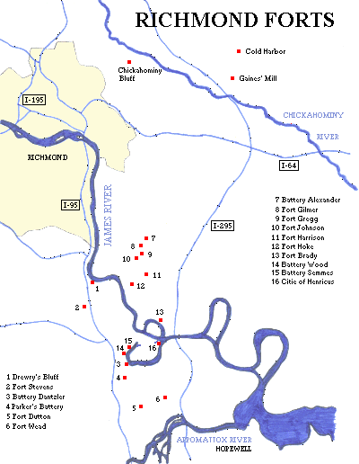
The main park includes the 1864 Confederate forts of Fort (or Battery) Alexander, Fort Gilmer, Fort Gregg (1), Fort Johnson, Fort Harrison (2) (renamed USA Fort Burnham after capture), Battery White, Fort Hoke, Fort Maury, plus several other small unnamed batteries and miles of earthworks. The Federals built Fort Brady and Battery IV after Fort Harrison was captured and the trench lines were shifted. Chaffin's Bluff, opposite Drewry's Bluff, was fortified by the Confederates early in the war. Battlefield Tour Map
Outside the main park lies the CSA forts of Drewry's Bluff (1862 - 1865) (known as Fort Darling to the Federals), and Parker's Battery (1864). Drewry's Bluff also served as the Confederate Naval Academy and Marine Corps Camp of Instruction through much of the war. Fort (or Battery) Stevens, and Battery Dantzler (formerly Fort Howlett or Howlett's Battery), both from 1864, are part of the Chesterfield County Park System. There was also Fort Jackson (3) (no remains). There was also Battery Wood and Battery Semmes on the James River (see Dutch Gap below). Cold Harbor Battlefield had six miles of Confederate earthworks, with about two miles that are nicely preserved along the tour route. Chickahominy Bluff also has earthworks remaining.
Federal forts (1864) (no remains) once located outside the main park, mostly along the present-day route of I-295, include Fort Sawyer (near Dutch Gap), Fort Spofford, Fort Parsons, Fort Wilcox, Fort Drake (trace remnants exist along VA 10), Fort Carpenter, Fort Dutton, Fort Wead (part of Chesterfield Co. Park System), and Fort Zabriskie (near Port Walthall).
Also located in Richmond was a CSA training camp (1861) at the present-day Monroe Park, later the barracks of the Richmond City Guard, and later the Stuart Military Hospital; the Belle Isle Prison Camp on Belle Isle on the James River; and Libby Prison on Cary Street. Union prison/parole camps in 1865 included Camp Lee and Camp Winder, former CSA camps.
Richmond was surrounded by three defensive fortification rings. The outer ring circled 10 miles out on the north and east sides of town, for a length of about 65 miles. An intermediate line was four miles out. These two lines were never fully completed, and rarely manned. The inner line just outside the war-time city limits consisted of 17 numbered "star" forts and seven outworks. These works were essentially completed before Petersburg fell. None of these works exist today. Approximate locations of the star forts were:
#1 at the James River and Almond Creek.
#2 at Osborne and New Osborne Turnpikes, with outworks.
#3 at Darbytown and Williamsburg Roads.
#4 at O and 36th Streets, with an outwork at 40th and M Streets.
#5 at Nine Mile and Creighton Roads.
#6 at Mechanicsville Turnpike and I-64.
#7 at Richmond-Henrico Ave. and Willow Street, with outworks.
#8 at Battery Park.
#9 at VA Union University.
#10 at Broad Street and Science Museum of VA.
#11 at Main or Cary Streets and Stafford or Davis Aves.
#12 at Maymont Park.
#13 at Riverside Drive and 20th Street.
#14 at Riverside Drive and Forest Hill Park (Reedy Creek).
#15 at Midlothian Turnpike and 32nd Street.
#16 at Maury Street and Holly Spring Ave.
#17 at Maury Street and Jefferson Davis Highway.
(NOTE: Exact locations could not be determined from maps at hand.)
Bellona Arsenal (ruins)
(1816 - 1837, 1863 - 1865), Richmond
A state arsenal located on the south bank of the James River, just outside the city limits. It was sold in 1837. The Confederate government leased it during the Civil War, then known as Richmond Arsenal.
Coxendale Forts
(1612 - 1622), Coxendale
An early settlement near Henricus, protected by four forts or blockhouses known as Fort Charity (aka Fort Hope in Faith), Fort Elizabeth, Fort Patience, and Fort Mount Malado. The town was abandoned after the 1622 Indian raids.
Citie of Henricus
(Henricus Historical Park)
(1611 - 1622), Dutch Gap
The seven-acre palisaded settlement is currently under reconstruction. This was the second permanent settlement in the state. The settlement had three streets, and there were five watchtowers, one at each corner of the palisade. In 1622, Indians entered the fort and used the colonists' own weapons to slay them. Sir Thomas Dale used a Dutch fortification technique to dig a ditch and construct a palisade behind the ditch to protect the village. The land masses on either side of the ditch became known as "Dale's Dutch Gap".
Dutch Gap Battery
(1864), Dutch Gap
CSA Signal Hill Battery (2) was located across the river from where Union troops were building the Dutch Gap Canal. The canal was to be a shortcut through the winding James River, cutting off nearly five miles - and bypassing this Confederate battery and also Batteries Howlett, Wood, and Semmes (mentioned above in the Richmond section). The Rebels were constantly firing on the Union troops and caused numerous delays of the canal's construction. The war ended before construction was complete. The canal was finished in 1871 and a lighthouse was built here.
Chesterfield Courthouse Camp
(1780 - 1781), Chesterfield Court House
A training camp of reinforcements for the Continental Army enroute to Yorktown.
Rochdale Hundred Palisade
(1613), near Meadowville
A four-mile long palisade surrounded the settlement on Jones Neck.
Bermuda Hundred Palisade
(1613), Bermuda Hundred
A two-mile long palisade surrounded the settlement.
Camp Bottoms Bridge
(1814), Bottoms Bridge
A large state militia camp on the Chickahominy River.
Bermuda Citie
(1614 - 1622, 1624 - unknown), Hopewell
A palisaded settlement with several blockhouses and trenches, located at present-day City Point. It was rebuilt after the 1622 Indian raids. Also known as Charles Citie (not to be confused with the present-day Charles City located in Charles City County).
Fort Charles (2)
(1644 - unknown), near Hopewell
Built near the head of navigation on the James River somewhere in the vicinity of Hopewell and Bermuda Hundred.
(NOTE: one source puts this fort at the Falls of the James River in present-day Richmond.)
Hopewell Civil War Defenses
(Petersburg National
Battlefield)
(1864 - 1865), Hopewell
At City Point was Union City Point Fort built to protect the supply depot in 1864 and 1865, located in a city park on Appomattox Street. Other Union forts around Hopewell included Fort Abbott, Fort Craig (2), Fort Graves, Fort McKeen, Fort Lewis O. Morris, Fort Merriam, Fort Gould, and Fort Porter (2).
Fort Henry (2)
(1645 - 1649?, 1675, 1685?), Petersburg
A VA colonial militia fort at the falls of the Appomattox River. It was garrisoned again in 1675, and probably again in 1685. Location probably at or near McKenzie Street Park. Peter Jones' Post (1675) was a trading post located near Market and Old Streets, just east of the fort site. The city was named after Peter Jones.
Petersburg Civil War Defenses
(Petersburg National
Battlefield)
(1864 - 1865), Petersburg View Petersburg map
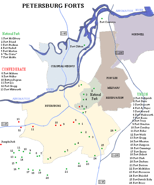
A total of 42 forts and 136 batteries were built by both sides during the Siege of Petersburg. The main park includes Union forts Fort Friend, (originally CSA Battery 8), Fort Stedman, Fort Haskell, the site of Fort Morton (2), and the CSA forts Battery 5 (site of the Union Dictator mortar battery), Battery 9, Gracie's Salient, Colquitt's Salient, and "The Crater" which is the remains of a small CSA fort that was part of Elliott's Salient. Plus there are several other unnamed batteries. Admission fee. Battlefield Tour Map
Along Flank Road lies Union seige line forts including Fort Davis (aka
Fort Warren), Fort Alexander Hayes, Fort Howard, Fort
Wadsworth, Fort Keene, Fort Tracy, Fort Urmston,
Fort Conahey, and Fort Fisher.
Other Union seige line forts included Fort McGivery, Fort Meikle, Fort Rice, Fort Sedgwick (aka Fort Hell), Fort Welch, Fort Gregg (3) (USA), Fort Sampson, Fort Wheaton, (originally CSA Fort Archer), Fort Cummings, Fort Emory, Fort Seibert, Fort Clark, Fort Dushane, Fort Davison, Fort McMahon, Fort Stevenson, Fort Blaisdell, Fort Patrick Kelly, Fort Prescott, Fort Bross, and many other unnamed batteries. Siege of Petersburg.
Confederate defense line forts included Battery 1, Battery 16 and Battery 20 (part of the Dimmock Line), Rives' Salient, Fort Mahone, Fort Walker, Battery Pegram, Battery 40, Fort Lee (2) (aka Battery 45)(no relation to the current military reservation), Battery 47, Fort Gregg (2) (CSA), Fort Baldwin, Fort Whitworth (still remains in picnic area of Central State Hospital), Battery 55, and many other unnamed batteries.
Other forts in the area include CSA Fort Clifton (Park and Archaeological Site), on Conduit Road by the Appomattox River in Colonial Heights, and Union Fort Converse between Petersburg and Hopewell, at a present-day federal reformatory near the I-295 bridge. Union Redoubt (or Battery) Anderson was located near Bermuda Hundred.
Another interesting site nearby is Pamplin Historical Park, which also has the National Museum of the Civil War Soldier (admission fee). Several Confederate trenchworks are located here, as well as artillery emplacements, and camp sites. The earthworks extended west to Five Forks. Also located near here is White Oak Battlefield Park, a Dinwiddie County park with CSA earthworks and trenches (1865).
Petersburg CSA Arsenal and Ordnance Depot
(1862 - 1865), Petersburg
A CSA Arsenal and/or Ordnance Depot was located in the city. Undetermined location.
Camp Distribution (2)
(1865), Petersburg
A Union supply depot located in a former tobacco factory on the southwest corner of High and Lafayette Streets.
Fort Christanna (Archaeological Site)
(1714 - 1718), Lawrenceville
It was built by the VA colonial militia for protection of settlers and friendly Indians against the Tuscarora. A school for the Saponi Indian children was established here after the fort was abandoned. In 1924 the site was marked by a cannon, one of five from the stockade. Excavated in 1978. Some earthworks may possibly remain.
Fort Nottoway
(unknown), near Blackstone
Located on the Nottoway River.
Staunton River Fort
(Staunton River Battlefield State Park)
(1864), Randolph
CSA earthworks and a small fort remain on a walking trail in the park. Built to protect the railroad bridge across the river. The bridge was held after the battle, but was burned in 1865 on Lee's retreat to Appomattox. The current bridge was built in 1902.
Reedy Creek Archaeological Site 
(900 - 1400), near Mount Laurel
A palisaded Indian village site of the Late Woodland Period, located on Reedy Creek at the Staunton River. Excavated in 1925. Artifacts also recovered from the Late Archaic Period (2000 - 1000 BC).
Danville Earthworks
(1865), Danville
CSA earthworks are still located on the hills above the Dan River, off of US 58. Danville was the last capital of the Confederate States of America.
NEED MORE INFO: Fort McHenry Parkway, Fort King Drive, and Fort Hill Drive in western Henrico County; Fort Sumter Road in western Chesterfield County, Fortview Drive in eastern Chesterfield County, and Fort Myers Road in central Hanover County. A possible fort location in Colonial Heights at Battery Place. Fort Alvis in eastern Henrico County. Battery Street in Emporia. Battery Street in Lynchburg.
Towns: Fort Mitchell south of Keysville
Northern Virginia - page 1 | Eastern Virginia - page 3 | Hampton Roads Area - page 4
Northwestern Virginia - page 5 | Southwestern Virginia - page 6