Fort Adams |
Fort Anne |
Fort Barton |
Beaver Head Fort |
Beaver Tail Fort |
Bonnet Point Fort
Brenton's Point Barracks |
Brenton Point Res |
Brenton's Point Fort |
Bull Garrison |
Fort Burnside |
Fort Butts
Butt's Hill Fort |
Canonchet's Fort |
Castle Hill |
Fort Church |
Fort Conanicut |
Fort Dumpling Rock |
Fort Dumplings
Dutch Island Battery |
Eldred's Battery |
Fox Hill Fort |
Fort George |
Fort Getty |
Fort Greble |
Fort Greene
Fort Nathaniel Greene |
Green End Fort |
Fort Hamilton |
Fort William Henry |
Fort Hill |
Fort Independence
Fort Kearny |
King Philip's Fort |
Fort Leverett |
Fort Liberty |
Fort Louis |
Fort Mansfield
Mount Hope Fort |
Fort Neck Lot |
Newman Garrison |
Fort Ninigret |
Oaks Inn Res |
Prospect Hill Fort
Pumham's Fort |
Queen's Fort |
Old Rehoboth Garrisons |
Sachuest Point Battery |
Sassafras Hill Fort
Smith's Castle |
Fort Varnum |
Fort Washington |
Fort Wetherill |
Fort Wolcott
Fox Hill Fort

(1775 - unknown), Providence
Armed with six 18-pounders and four smaller guns. Located at Fox Point. No longer exists.
Fort Independence

(1775 - 1810's), Providence
Located on Robin Hill and was once connected by earthworks to Sassafras Hill Fort on Sassafras Point, which no longer exists. Fort Independence has been restored and is now a park.
Fort William Henry
(1812 - 1815), Providence
From the War of 1812. Located at Fields Point. No longer exists.
Newman Garrison

(1674 - 1676), Rumford
A fortified parsonage, once located on the north side of Newman Ave. near Meeting House Pond. It was destroyed during King Philip's War. Rumford was considered part of Massachusetts until 1862.
Old Rehoboth Garrisons
(1674 - 1676), East Providence
Several garrison houses were once here. They were destroyed during King Philip's War. East Providence Township was once known as Rehoboth, and was part of Massachusetts until 1862.
Fort Hill
(1775 - 1810's), East Providence
Located at Bold Point. Some earthworks remain.
Pumham's Fort

(1644 - 1676), Warwick
A Narragansett fort built by the colonial militia for mutual protection. The site is located on Paine Street, overgrown.
King Philip's Fort
(1660's - 1675), Mount Hope, Bristol
The main village of the Pokanokets, and Metacom's (King Philip's) stronghold. The colonials drove out the Indians in 1675, and built a temporary fort, Mount Hope Fort, which lasted only about one month.
Fort Leverett
(1675), North Tiverton (or Fall River, MA)
Built by the colonial militia near Pocasset Swamp.
�� Older Newport Area Forts
NOTE: Newport was occupied by the British from 1776 thru 1779. The French occupied it from 1780 thru 1781 while their fleet was anchored there.
According to a French map there were 39 forts and batteries located in the Newport and Middletown areas in 1780 and 1781.
�� Fort Barton
(1776 - 1781), Tiverton
Redoubt still exists. Staging area for the Battle of Rhode Island.
�� Butt's Hill Fort
(1777 - 1778), Portsmouth
Also known as Fort Butts, it was built by the British and later occupied by Patriots. The redoubt still exists. Scene of the Battle of Rhode Island.
The British recaptured the fort and the Patriots retreated back to Tiverton. Lack of cooperation from the French fleet was blamed on the American defeat.
�� Green End Fort
(1776 - 1779), Middletown
The redoubt still exists. This fort was at the eastern end of British defensive
lines around Newport.
(info provided by Rolland Everitt)
�� Castle Hill

(1776), Brenton Point, Newport
It was once fortified by Patriots, but the battery was never completed and it was replaced by a new battery at the future site of Fort Adams. Also known as Brenton's Point Fort. It was abandoned when the British arrived and it was destroyed when they left in 1779. The French also used it from 1780 to 1781.
�� Fort Hamilton
Rose Island Lighthouse
(1798 - 1811?), Rose Island, Newport
A British battery was on the island in 1778, and in 1780 - 81 the French built a fort here after the British left Newport. Construction of the American fort was never completed. In 1853, it was listed as being old. The lighthouse was built in 1869 on the southwest bastion of the fort. Beginning in 1883, the old fort was used as a storage area for explosives and torpedoes for the US Navy. Additional magazines and barracks were built after World War I. The Navy left in the 1950's. The island became a city park in 1984. Most of the island is off-limits to the public, however the lighthouse is open for tours.
�� Fort Wolcott
(1798 - 1869), Goat Island, Newport
Originally known as Fort Anne (1703 - 1724).
Renamed to Fort George in 1724, Fort Liberty in 1775, and Fort
Washington in 1789. The Patriots briefly used this fort in 1776. The British held it until 1779 when the Patriots got it back. The French used the fort in 1780 and 1781. The 28-gun fort later became Fort Wolcott and was used until 1836, although it remained the property of the Army until well after the Civil War. A Navy torpedo station was here from 1869 to 1950. Most of the buildings were demolished in the 1960's. Now a developed area.
�� Fort Greene
(1776 - 1800?), Newport
A Patriot and Federal fort located in Battery Park, across from Fort Wolcott. It was an elliptical stone battery in ruins by 1811.
(Not to be confused with Fort Nathaniel Greene in Point Judith)
�� Prospect Hill Fort
(1776 - 1781), Jamestown
Used by the French in 1780 and 1781. Located here are several towers used in World War II.
�� Beaver Tail Fort
(1776), Jamestown
Along with the nearby Beaver Head Fort, they were captured by the British. The current remains at Beaver Head are of British construction.
On the east side of Conanicut Island was Eldred's Battery (American).
�� Fort Conanicut
(1779 - 1800), Jamestown
Used by three different armies during the American Revolution. It was originally Patriot Dumpling Rock Battery (1776), then British Fort Dumpling Rock (1776 - 1779). Later it was American Fort Louis (1800), and Fort Dumplings (1800 - 1824). In 1818, it was a 10-gun fort. A stone tower mounting eight guns was erected in 1800, named Dumplings Tower. The fort was replaced by Fort Wetherill. The earthworks fortification will be
restored in the future.
�� Bonnet Point Fort
(1777 - 1860's, intermittent), Wickford
Also known as Bonnet Battery, it was used during the Revolution by Patriots and Brits. It was also used by the US during the War of 1812 and the Civil War. It still exists. A WWII observation tower is also still here.
� HARBOR DEFENSES of
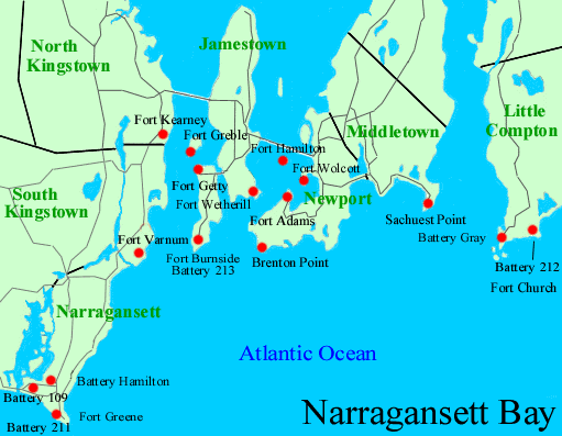
NARRAGANSETT BAY
View Narragansett Bay Map
� Fort Church
(1942 - 1948), Sakonnet
This fort is in three separate sections. The West Reservation, at Sakonnet
Point, included Battery Gray / 107 (1942 - 1948), now partially covered and used as a golf club. The East Reservation had Battery Reilly (1942 - 1947), which is buried. The South Reservation, at Warren Point, has Battery 212 (1943 - 1948), and it has been built on and partially destroyed. This fort also had two panama mounts for 155mm guns (1942 - 1944), which may still remain buried. One fire-control tower remains here, now a private home.
� Sachuest Point Battery
(1917 - 1919), Middletown
Sachuest Point is on the Sakonnet River east of Newport. It was armed with
two 4.72-inch rifles from Fort Adams. One of these guns is now on display at
Equality Park on Broadway in Newport and the other is at Fort Moultrie in South Carolina. In WWII, a Navy radio station, three fire-control towers, and a radar tower were located here. Nothing left.
� Brenton Point Reservation
(State Park)
(1941 - 1946), Newport
Located here are an unnamed battery of four 155mm guns (1942 - 1943), which is mostly destroyed (one mount left), and Anti Motor Torpedo Boat Battery 923 (#3) (1943) mounts removed in 1989. Two radar sites were also here.
� Fort Adams
(State Park)
(1793 - 1946), Newport  SEE OUR
OWN PHOTOS
Previously here was Patriot Brenton's Point Barracks, which was captured in 1776, and then destroyed in 1779 as the British left. A unnamed Patriot fort was then built here in 1780. Fort Adams was then built later, and named in 1799. In 1818, it was a 17-gun fort. The current structure was built beginning in 1824. The Outer Redoubt was built in 1825. In WWII, an HDCP and an AA battery were here. Endicott batteries on the west side include Battery Belton (1907 - 1925), Battery Bankhead (1907 - 1913), Battery Reilly (1899 - 1917), and Battery Talbot (1899 - 1917). One gun of this battery is on display in Equality Park in Newport. On the south side are two mortar batteries, Battery Edgerton (1898 - 1943), and Battery Greene (1898 - 1943), which was renamed Battery Gilmore in 1940. There is also an unnamed battery from 1898 near Battery Bankhead. Mobile 90mm guns were also here in WWII. Another
website at moonbase.com and Another
website at salve.edu
� Fort Wetherill
(State Park)
(1896 - 1946), Jamestown
Located south of Jamestown, across from Fort Adams. It replaced Fort Dumplings. It was given its current name in 1900. Endicott batteries here are Battery Wheaton (1908 - 1945), Battery Varnum (1901 - 1943), Battery Dickenson (1908 - 1947) modified in WWII, Battery Zook (1908 - 1918), Battery Crittenden (1908 - 1946), Battery Cooke (1901 - 1920), Battery Walbach (1908 - 1942), and Anti Motor Torpedo Boat Battery 924 (#4) (1943) unfinished, which was previously an AA battery (1920's). A double mine observation station is located at the site of the former Dumplings Tower. Anti-submarine nets went across the harbor to Fort Adams from here. Several fire-control towers remain here.
� Fort Burnside
(Beavertail State Park)
(1940 - 1948), near Jamestown
Located south of Fort Getty, across from Brenton Point. Batteries here are
Battery 213 (1943 - 1948), and Battery Whiting (AMTB #5) (1942 - 1946). Battery 110 was to be built here. There are two mine casemates at Hull Cove, buried and built on.
� Fort Getty
(1900 - 1946), Jamestown
Located on the western side of Conanicut Island in a city park. Batteries here were Battery Tousard (1910 - 1942) partially buried, Battery House (1910 - 1942) mostly buried, Battery Whiting (1910 - 1942), and Anti Motor Torpedo Boat Battery 922 (#2) (1943 - 1946), which is partially buried.
� Fort Greble
(1863 - 1946), Dutch Island
Located north of Fort Getty. Batteries here are Battery Sedgwick
(1901 - 1942), Battery Hale (1898 - 1942), Battery Mitchell
(1905 - 1917), and Battery Ogden (1900 - 1920). An AA battery (1925) is adjacent to Battery Mitchell. An unnamed battery from 1898 was destroyed and replaced with Battery Mitchell. Dutch Island may have been fortified since 1830. During the Civil War, there was Dutch Island Upper Battery and Lower Battery. The new Battery at Dutch Island was unfinished in 1873. Positions for thirteen 15" Rodmans still remain here.
� Fort Kearny
(1899 - 1946), Saunderstown
Replaced Bonnet Point Fort. It was named in 1905. It was the ferry and supply terminal for Forts Greble and Getty. It is now the site of the URI School of Oceanography. Batteries here are Battery French (1908 - 1917), which is built on, Battery Cram (1908 - 1943), and Battery Armistead (1908 - 1942), which is also built on.
(Some info provided by J. Cannon)
� Fort Varnum
(1941 - 1947), Boston Neck
Located in between Fort Kearny and Fort Greene and situated opposite Fort
Burnside. Batteries here are Battery House (1942 - 1947), Battery
Armistead (1942 - 1946), and Anti Motor Torpedo Boat Battery 921 (#1) (1943 - 1946). Four observation towers remain here.
� Fort Nathaniel Greene
(Fisherman's Memorial State Park)
(1934 - 1948), Point Judith
A Patriot fort was here along with the first lighthouse. In 1818, it was a
6-gun fort. It was abandoned by the 1850's. The "modern" fort was originally named the Point Judith Reservation until 1941. Fort Greene is divided into three separate sections. The East Reservation has Battery Hamilton / 108 (1943 - 1948). The National Guard still uses this part. The West Reservation has Battery 109 (1944), and an unnamed four-gun 155mm battery with panama mounts that are mostly buried in a housing development. The state park is here. The park's office uses a former fire-control tower. The South Reservation has Battery 211 (1945 - 1948) at the water's edge, and is a city park. Several towers were near this battery. Observation posts were
built here for World War II, but instead of being the usual design, they were
built to resemble beach houses.
(Not to be confused with Fort Greene in Newport)
� ALSO: Additional fire-control towers for the Newport Defenses were located at Prospect Hill (six remain), Green Hill (none remain), Weekapaug Point (none remain), Watch Hill Point (none remain), Block Island (four remain), Gay Head on Martha's Vineyard, Mass. (one remains), Cuttyhunk Island, Mass. (three remain), and at Gooseberry Point, Mass. (two remain).
Some information provided by Alex Holder of the Coast Defense Study Group, and also by John Duchesneau of the Fort Adams Trust.
Smith's Castle
(1660's - 1676), Wickford
A garrison and trading post built on the site of, or nearby, Roger William's original trading post. This was the base of operations for colonial troops against the Narragansett and Wampanoag during "The Great Swamp Fight" of 1675. It was destroyed in 1676, and rebuilt in 1678. The much altered house is now a museum, located on Richard Smith Drive.
Bull Garrison
(1675), Narragansett
A stone house once located on Tower Hill on the west side of Middle Bridge Road. It was destroyed during King Philip's War, and was rebuilt in 1684. The site was excavated in 1918. Surrounded by private property.
Queen's Fort
(1675), Exeter
Indian survivors of "The Great Swamp Fight", which was near West Kingston, took refuge here. This was a stronghold of the Narragansett. The ruins of the semi-circular bastion consist of a low wall of rocks on a hilltop. The site was never discovered by the colonial militia during King Philip's War. Located west of Route 2 on the south side of Stony Lane.
Canonchet's Fort
(Great Swamp Wildlife Preserve)
(1675), West Kingston
A Narraganset Indian fortified village in the Great Swamp. Somewhere between 100 and 340 Indians were massacred here. The monument for the fort and battle is located about two miles (north?) from the actual site on Great Neck. There is a Stony Fort Road on the northern side of Kingston.
Fort Ninigret (park)

(mid 17th-century), Charlestown
Used by the Niantic Indians, possibly as a defense against settlers or Pequot Indians. Originally this was a Dutch fort called Fort Neck Lot.
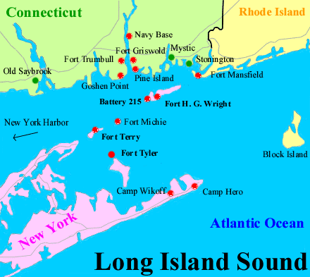
� HARBOR DEFENSES of EASTERN LONG ISLAND SOUND (partial)
View Long Island Sound Map
�� Fort Mansfield
(1898 - 1917), Watch Hill
Located on Napatree Point. Batteries here are Battery
Wooster (1901 - 1917), Battery Crawford (1901 - 1917), and
Battery Connell (1901 - 1917), which is submerged in the surf due to a
hurricane in 1938. It is visible at low tides. A fire-control tower no longer remains.
�� Oaks Inn Reservation
(1940's), near Avondale
Site of four panama mounts for 155mm guns, three mounts remain, one is still buried. Battery 114 was to be built here. The Officers' Quarters still remain here.
�� ALSO: Additional fire-control towers in Rhode Island associated with HD Long Island were located at Block Island (three remain), Green Hill (no longer remains), Charlestown (one remains), and at Weekapaug Point (no longer remains).
Information on the forts and garrison houses during King Philip's War was gathered from "King Philip's War: The History and Legacy of America's Forgotton Conflict" by Eric Schultz and Michael Tougias, The Countryman Press 1999.
 Books about Forts in Rhode Island