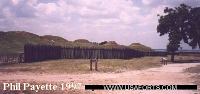
Fort Amory |
Fort Anderson (1) |
Fort Anderson (2) |
Battery Atlantic Beach |
Fort Barnwell |
Bear Inlet Fort
Fort Benjamin |
Battery Bolles |
Camp Branch |
Fort Branch (1) |
Battery Buchanan |
Camp Burgwyn |
Fort Campbell (1)
Fort Campbell (2) |
Carolina City Camp |
Fort Caswell (1) |
Fort Caswell (2) |
Fort Chase |
Fort Cobb
Croatan Earthworks |
Camp Davis |
Fort Davis |
Fort Dobbs (2) |
Fort Dutton |
Fort Ellis |
Fort Fisher |
Fort French
Fort Gaston |
Battery Gatlin |
Camp Glenn |
Half-Moon Battery |
Fort Hampton |
Fort Hancock |
Camp Hoffman
Fort Holmes |
Huggins' Island Fort |
Fort Johnston |
Kinston Defenses |
Kure Beach Res |
Fort Lamb |
Fort Lane
Fort Lee |
Battery Lookout |
Battery Macon |
Fort Macon |
Fort Meares |
Newport Barracks |
Fort Nooherooka
Old Fort |
Fort Pender |
Camp Radcliff |
Fort Rowan |
Fort St. Philip's |
Battery Shaw |
Fort Spinola
Fort Stevenson |
Fort Stokes |
Fort Strong |
Fort Thompson |
Fort Totten |
Fort Union
Wilmington Forts |
Zeke's Island Battery
Northeastern North Carolina Forts - page 2 | Western North Carolina Forts - page 3
Fort Holmes

(1862 - 1865), Bald Head Island
An extensive earthworks fort located west and south of the lighthouse. The lighthouse was built in 1818. The main work was called Battery Holmes (eight guns and two magazines revetted with palmetto logs), located at the extreme western tip of the point. This may have eroded away. Continuing southeast was Battery #1 (one gun and a magazine) and Battery #2 (one gun). These also may have eroded away. Along the line northeast to the lighthouse was located Battery #3 (five guns and two magazines), an unfinished battery, and then Battery #4 (four guns and two magazines) surrounding the lighthouse. This portion still exists. The fort was destroyed to avoid Union capture. During the war, the island was called Smith's Island.
� COAST DEFENSES of WILMINGTON
� Fort Caswell (2)

(1826 - 1865, 1894 - 1926, 1941 - 1946), Oak Island
Construction continued until 1838, and it was one of only three
masonry forts in the state before the Civil War. It was named in 1833 and
captured by the Confederates in 1861. Built of stone and earthworks, it was
partially destroyed in a mine explosion during the Civil War and was abandoned only when Fort Fisher fell in 1865. The fort is on private property, but tours can be arranged. A small earthwork battery may have been located here in 1813. Modern coastal defense batteries here are Battery Bagley (1903 - 1925), Battery Caswell (1899 - 1925), which was modified for a swimming pool, Battery Swift (1898 - 1920), Battery New Madison (1905 - 1917), Battery McDonough (1902 - 1905), Battery Shipp (1901 - 1919), Battery Madison (1899 - 1904), Battery McKavett (1903 - 1920), and Battery New McDonough (1904 - 1925). Several of the post buildings remain in good condition. A fire-control tower still remains near the lighthouse. The reservation was used in WWII as a Navy Section Base and Army Depot
Located to the west of the old fort were the Confederate earthworks Battery Shaw (one gun), and Fort (or Battery) Campbell (1) (both 1862 - 1865). They were destroyed in order to avoid capture. Fort Campbell had 18 guns and a large bomb-proof magazine, and was located about where Battery Shipp is now located. Battery Shaw was located about halfway between Fort Campbell and Fort Caswell, at the location of Battery Swift. Battery Island is also nearby.
Fort Johnston


(1748 - 1881), Southport
Johnston's Fort was built in 1748 and it was attacked by the Spanish fleet that same year. It was a small wooden square-shaped fort with four bastions and sand earthworks. It was rebuilt beginning in 1754 into a
star-shaped stone and tabby fort with four bastions and a dry moat.
It was rebuilt again in 1773, but destroyed by Patriots in 1775. Rebuilt by the Patriots in 1778. The British recaptured it in 1781 only to abandon it. Rebuilt yet again beginning in 1794.
The Garrison House was built in 1810 and is the only part that remains today. Three other buildings, including the 1835 hospital, also exist but they have been moved into town and were converted into houses. Various government and military agencies have used the house up to the present day. The Sunny Point U.S. Military Ocean Terminal currently uses it.
This fort was one of only three masonry forts in the state before the Civil War.
The fort was seized by the CSA in 1861, but by 1862 it was only sand earthworks and sod covered mounds for four guns and two magazines. Known as Fort Branch (1) in 1862 and 1863. Known as Fort Pender in 1863 and 1864. The Union captured it in 1865, but until then it helped keep Wilmington open to blockade runners.
New buildings were built in the 1870's, but the fort closed in 1881. A searchlight position was here in World War II.
Fort Lamb
(1862 - 1865), near Southport
Part of the Wilmington defenses. It was located on Reeve's Point at the present-day Sunny Point U.S. Military Ocean Terminal.
Camp Radcliff
(1861 - 1865), near Fort Johnston
A CSA camp.
Fort Anderson (1)
(Brunswick Town State Historic Site)
(1862 - 1865), Brunswick Town
�National
Archives MAP�
First known as Fort St. Philip's until 1863, it was built on the ruins of Brunswick Town (1726 - 1776). Only earthworks remain. It had 10 guns in two batteries in the main work, and three seperate batteries along a line to the west. It was held until 30 days after Fort Fisher fell. The restoration of Brunswick Town is in progress. It is located on the Cape Fear River north of Southport. The fort was originally named after St. Philip's Church, which still exists as ruins. A visitors' center and museum are here.
Fort Fisher
(State Park)
(1861 - 1865), Kure Beach
�National
Archives MAP 1� | �National Archives MAP 2�
Originally called Battery Bolles, it was rebuilt in 1862. It covered
one mile of the shoreline on the eastern flank (eight seperate batteries) and one-third mile of land defense on the northern flank (about 30 guns). It also included Battery Lamb (also known as Mound Battery) as the southern anchor. This fort was the last major stronghold of the Confederacy and was not captured until after several Union attempts in January 1865. It kept the Cape Fear River clear of Union ships. Much of the earthworks have eroded into the sea. The palisades on the north flank have been reconstructed. There is a visitor center. Three miles north along the shore was an unnamed battery. Guarding the entrance to New Inlet was once Battery (or Fort) Buchanan, a four-gun elliptical earthwork at the tip of Federal (Confederate) Point. There was also Zeke's Island Battery (the site no longer exists). New Inlet has shoaled over. *PHOTO*
TEMPORARY HARBOR DEFENSES of WILMINGTON
Kure Beach Reservation
(1942 - 1944), Kure Beach
A four-gun 155mm battery in revetments located outside Fort Fisher to defend the inlet to Wilmington. This may have been at the location of the present-day Fort Fisher Air Force Station.
Battery Gatlin
(1862 - 1865), Carolina Beach
The Union called it Half-Moon Battery. It was part of the Confederate Wilmington defenses. At Sugarloaf on the riverside (Carolina Beach State Park) was a CSA signal station for Fort Anderson. Trenches still remain in the woods.
Wilmington Forts
(1862 - 1865), Wilmington
The city was surrounded by earthwork batteries. From south to north were McRae Battery, Parsley Battery, Bellamy Battery, Wright Battery, McRee Battery, Dawson Battery, Moore's Bastion, Miller Battery, Hobson Battery, Smith's Battery, Andrew Battery, and Green's Battery. To the south were Fort French and Fort Stokes (aka Fort Davis). Further south were Fort Lee, Fort Campbell (2), and Fort Meares, which were collectively called Fort Strong by the Union (located at the state port across from Campbell Island). These forts guarded obstructions in the river to block the Federal gunboats. To the east in Pine Valley (Forks Road Battlefield) are remains of earthworks located at 17th Street Extension and Independence Blvd. South of the airport across from Smith Creek was Confederate Camp Burgwyn. The city surrendered only after Fort Fisher fell.
Camp Davis
(1940 - 1946?), Holly Ridge
A Coast Artillery AAA and barrage balloon training center during World War II. The HQ building was restored as a restaurant in 1974.
Camp Branch
(1941 - 1946?), Jacksonville
A Coast Artillery training range and camp, located at the present Camp Lejeune Marine Base.
Bear Inlet Fort
(Hammocks Beach State Park)
(1749 - unknown), Bear Island, near Swansboro
A small wooden fort was once located here for protection against
the Spanish. The actual site has eroded into the sea.
Huggins' Island Fort
(1862), Huggins Island, near Swansboro
A Confederate six-gun fort guarding Bogue Inlet. It was burned by the Federals
in 1862. There are still some remains left. Administered by Hammocks Beach State Park.
Carolina City Camp
(1862), Morehead City
A large Confederate camp covering over one square mile in area. It was taken
by the Union in 1862 during the Fort Macon campaign.
Also located here was Camp Glenn, a National Guard camp (1911 - 1918)
followed by a Navy base (1918 - 1920). Then it became the first U.S. Coast Guard air station (1920 - 1921). The Navy returned in 1941 for use as an Area Section Base.
Fort Macon
(State Park)
(1834 - 1903, 1941 - 1945), Atlantic Beach  SEE OUR OWN PHOTOS
Earlier forts were located here, including: Fort Dobbs (2) (1756), which was never completed, and Fort Hampton (1809). The sites of both eventually eroded into the sea. The current fort was one of only three masonry
forts in the state before the Civil War. The Confederates held it from 1861 to 1862. The fort was used as a federal prison from 1865 to 1876. A temporary battery was set up on the parapet in 1898. This was the second state park in North Carolina (1924). It was restored in 1935. The Army regained the use of the fort in WWII, and demolished almost every new structure prior to handing it back to the state after the war. Fort Macon is currently undergoing extensive repairs. Another website at CrystalCoast.com.
TEMPORARY HARBOR DEFENSES of BEAUFORT INLET
(Fort Macon State Park) (Cape Lookout National Seashore)
(1941 - 1945), Atlantic Beach, Cape Lookout SEE OUR OWN PHOTOS
On the beach at Ft. Macon during World War II was Battery Macon, which had four 155mm GPF guns (1941-1942) in revetments and two 6-inch naval guns
(1942-1944) on concrete mounts. It is now buried in the surf. Two 75mm field guns were emplaced on Bogue Point in 1941. Two mobile 90mm guns were emplaced on Bogue Point (1944-1945) near the rock jetty, as an examination battery. Battery Atlantic Beach (1941-1942), four 155mm GPF guns in revetments, was located two and a half miles west of Atlantic Beach, almost due south of Camp Glenn in Morehead City. Two guns were later sent to Cape Lookout. There was a concrete observation post and plotting room (now in ruins) behind Battery Macon, another observation post by Battery Atlantic Beach, and a Harbor Entrance Control Post (dismantled after the war) on the parapet of Fort Macon. Another observation post was located on Shackleford Banks, on the western side by the inlet, and another about two miles west of Battery Atlantic Beach on Bogue Banks. There were seven searchlight positions from Atlantic Beach to Cape Lookout Point.
At Cape Lookout was Battery Cape Lookout which had two 155mm GPF guns (1942) in revetments, and later two 5-inch naval guns (1942-1944) on concrete mounts. That battery is now in the surf near the old Coast Guard Station. An SCR-296A radar tower was in the dunes in front of the Coast Guard Station, and a Battery Commander's tower was on the shore behind the battery. Observation posts were located on Shackleford Banks near Bald Hill Bay, and on South Core Banks about four miles northeast of the Lighthouse. A Naval Radio Compass tower was 340 yards west of the SCR-296A radar tower. There were four 75mm guns (1941-1943) in field emplacements around the Coast Guard Station. Lookout Bight was a mined and net-protected safe anchorage for allied merchant ships until 1944.
Fort Hancock

(1778 - 1780), Cape Lookout
Built by the French to protect their ships in Lookout Bight. It was later dismantled.
Newport Barracks
(1862 - 1865), Newport
The Union command post for the defensive system from New Bern to Morehead
City.
Fort Benjamin ?
(1860's?), Newport
A Union fort.
Fort Thompson
(1861 - 1862), Riverdale
A 13-gun earthwork located about halfway between New Bern and Havelock. It was captured by the Federals in 1862. CSA trenches were once located in present-day Craven County Fairgrounds. A few miles southeast are the remains of the Confederate Croatan Earthworks, which were found abandoned by the Federals as they advanced to New Bern.
� New Bern Forts
� Fort Lane
(1775 - 1865), New Bern
Located on Fort Point (Union Point Park), originally called Fort
Caswell (1). The Confederacy renamed it. The Union captured it in 1862. Fort Ellis was one of six other rebel forts around New Bern that were captured.
� Fort Totten
(1862 - 1865), New Bern
Trenches were built from the Neuse River to the Trent River west of town after the town was captured by Federal forces, with a fort in the center and a fort at each end. This five-bastioned fort was the southern anchor. Now on private property. Fort Rowan was the middle fort in the line, guarding the railroad into town. Fort Dutton (aka Fort Union) was at the end of the line at the Neuse River. Union Fort Stevenson was just west (upriver) from Fort Dutton. Several Confederate batteries (1862) were located along the Neuse River from New Bern to Kinston to prevent further Union advances.
� Fort Amory
(1862 - 1865), New Bern
The Union fort at the southern end of the trenches around New Bern, across the Trent River from town. Parts of its ramparts and ditch can still be seen. A line of earthworks went east, and connected to Fort Spinola on the Neuse River, with a Blockhouse in the center guarding the railroad coming into town from the south.
� Fort Gaston
(1862 - 1865), New Bern
A palisaded fort guarding the bridge across the Trent River, upriver (south) of New Bern on the east bank, south of Fort Amory. Barracks were located outside the palisade. Earthworks remain. It is now private property. Upriver from here was an Old Fort (date unknown). A Blockhouse was further south, guarding a Union cavalry camp.
� Fort Anderson (2)
(1862 - 1865), Bridgeton
A Union fort located across the river from New Bern and Fort Dutton. Downriver was Union Fort Chase.
Camp Hoffman
?
(1860's), near New Bern
A Civil War camp, possibly Confederate, located northwest of New Bern along the railroad. A Blockhouse was located nearby.
Fort Barnwell
(1712), Fort Barnwell
Built by the South Carolina colonial militia during a campaign against the Tuscarora. The remains are two miles north of town.
Fort Nooherooka

(1711 - 1713), Snow Hill
A Tuscarora palisaded stronghold that was taken by troops from South Carolina after a two year struggle. Afterwards they relocated to New York to join the Five Nations Confederacy. A marker is on the site at Snow Hill. There are several spelling variations.
Kinston Defenses
(1862 - 1865), Kinston
Union earthworks (1865) remain at Wyse Fork. Confederate earthworks remain along Southwest Creek in Woodington (private property). Confederate earthworks once were located along Southwest Creek in Caswell, and in South Kinston guarding the old railroad bridge across the Neuse river.
 Books about Forts in North Carolina