(1754 - 1760), New Gloucester
A blockhouse was here, also used as a church. It was sold in 1788.
Fort Allen |
Fort Andrews |
Bailey Island Res |
Camp Berry |
Berwick Garrisons |
Biddeford Pool Res
Black Point Fort |
Camp Burdette |
Fort Burrows |
Fort Buxton |
Buxton Garrisons |
Buxton Powder House
Cape Elizabeth Res |
Casco Fort |
Fort Dayton |
Dunstan Garrisons |
Fort Edward |
Eliot Garrisons
Falmouth Fort |
Fort Foster (2) |
Frank's Fort |
Fort Gorges |
Fort Gorhamtown |
Great Chebeague Island Res
Fort Gray |
Fort Hancock |
Camp Heyward |
Fort Hill |
Jewell Island Res |
Jocelyn Fort (2)
Jordan's Fort |
Fort Josselyn |
Kennebunk Point Fort |
Kittery Garrisons |
Fort Larrabee |
Fort Lawrence
Fort Levett |
Camp Abraham Lincoln |
Camp Long |
Long Island Res |
Fort Loyal |
Fort Lyon |
Fort McClary
Fort McKinley |
Fort Mary |
Munjoy Garrison |
Fort New Casco |
Fort New Gloucester |
New Marblehead Garrisons
Peaks Island Res |
Fort Pepperrell |
Phillips' Garrison |
Fort Preble |
Prout's Neck Fort |
Province Fort
Saco Blockhouse |
Saco Fort (1) |
Fort Saco (2) |
Fort Scammell |
Scottow Fort |
Spring Point Battery
Stage Island Fort |
Fort Sullivan (2) |
Fort Sumner |
Wells Garrisons |
Fort William |
Fort Williams |
York Garrisons
Northern Maine - page 1
FORTS of MAINE
Fort New Gloucester
(1754 - 1760), New Gloucester
A blockhouse was here, also used as a church. It was sold in 1788.
Fort Gray
(1755 - unknown), Gray
A town fort was once here.
Province Fort
(1744 - 1755 ?), South Windham
A palisaded blockhouse that was attacked five times by Indians between 1747 and 1755. At least five other palisaded blockhouses were in town in 1755. The settlement was originally called New Marblehead.
�� OLDER FORTS of
PORTLAND
Casco Bay
Area Forts
�� Fort New Casco
(1698 - 1716), Falmouth Foreside
A large earthwork and palisaded fort, also known as Casco Fort. It was attacked by the French in 1703, rebuilt 1705. It was demolished by the Massachusetts government due to budget cuts. Some earthworks may still exist on private property.
�� Fort Andrews
(1623), Cushing Island
A stone house that was built in 1623. It was later fortified (date unknown).
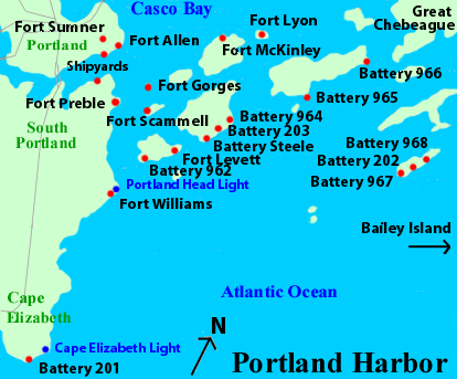
�� Fort Gorges 
(1857 - 1946), Hog Island Ledge, Portland Harbor
Construction was never fully completed, nor was it ever fully garrisoned. It was still kept on the Army rolls until WWII. The fort is now owned by the City of Portland, but no public transportation is currently available.
�� Fort Allen (park) 
(1775, 1814 - 1818?), Portland
Originally a Patriot five-gun half-moon battery in 1775. Rebuilt by the Massachusetts (Maine) state militia in 1814, it was enlarged and enclosed with a magazine and barracks. The earthworks still remain.
�� Fort Lawrence
(1814 - 1818?), Portland
Earthwork fort built by the state militia below Fort Allen at Fish Point. No longer exists. A Third System fort was later proposed for this location.
�� Fort Loyal

(1676 - 1690), Portland
Rebuilt and enlarged with four blockhouses and eight guns in 1690, but could not withstand the attack by the French that year, and was destroyed. Eventually rebuilt and renamed Falmouth Fort in 1742, located at the foot of present-day India Street. An earthwork was built here in 1775, called the Lower Battery. Nothing remains. Nearby were the Upper Battery (1776) at the upper end of Free Street, and Magazine Battery (1776) at Monument Square. Neither exists today.
�� Fort Sumner (Munjoy Hill Park)
(1794 - 1840's), Portland
This was the first federal fort built in Maine. It had a blockhouse, magazine, and barracks, with a Water Battery and gun house. Built on the site of Great Fort of 1775. No longer exists.
�� Fort Scammell
(1808 - 1898), House Island
Originally an octagonal blockhouse, with a semi-circular earthwork battery and a lunette battery, which were connected in 1845. It was enlarged during the Civil War to mount up to 17 guns. A British blockhouse preceeded this one in 1661. It was used through the Spanish-American War, and it still stands. AA guns were located here in the 1920's - 1930's.
�� Fort Burrows
(1813 - 1818?), Portland
A state militia fort located on Fore Street near Mountfort Street, at Jordan's Point. No remains left. Located here in 1675 was Munjoy Garrison. It was attacked during King Philip's War.
Some information provided by Ken Thompson of the Coast Defense Study Group.
� HARBOR DEFENSES of
PORTLAND
Casco Bay
Area Forts | Casco Bay
World War II History | View Portland Map
� Fort Preble
(Portland Harbor Museum)
(1808 - 1947), South Portland
Originally, this was a 14-gun fort. Built on the site of Patriot Spring Point Battery from 1776, which was renamed Fort Hancock in 1778. Exterior batteries were built in 1845 and rebuilt again in the 1870's. The outer casemates were built in 1863. It was attacked unsuccessfully in 1863 by
Confederate raiders. Camp Burdette was located here or near the fort during the Civil War. Seacoast batteries here were Battery Kearny
(1901 - 1942) destroyed, Battery Chase (1901 - 1942) destroyed, Battery Rivardi (1906 - 1918), Battery Mason (1906 - 1942), and Battery Mason II (1942 - 1946) washed away. A 37mm AA battery was also located here in WWII.
� Fort Levett
(1896 - 1948), Cushing Island
Batteries here were Battery Foote (1924 - 1948) casemated in 1944, Battery Bowdoin (1903 - 1943), Battery Kendrick (1903 - 1942), Battery Ferguson (1906 - 1947), Battery Daniels (1903 - 1920) partially buried, and Anti Motor Torpedo Boat Battery 962 (#2)(1943 - 1946). AA Battery #2 (1940's) was also located here, as are several observation towers. Private property.
� Peaks Island Reservation
(1942 - 1948), Peaks Island
Batteries here were Battery Steele / 102 (1942 - 1948), Battery
Cravens / 203 (1945 - 1948), an unnamed battery (1942 - 1943) partly
covered, replaced by AMTB 964, and Anti Motor Torpedo Boat Batteries 963 (#3) (1943 - 1946) and 964 (#4) (1943 - 1946), which was destroyed and buried. Several fire-control towers are still here, as are a mine casemate and mine towers. An SCR-296A radar was once located here. Also of interest here is the Fifth Maine Regiment Center.
� Fort McKinley
(1873?, 1896 - 1947), Great Diamond Island
Batteries here were Battery Ingalls (1904 - 1942), Battery Berry (1901 - 1943), Battery Thompson (1902 - 1942), Battery Weymouth (1901 - 1942), Battery Honeycutt (1901 - 1942), Battery Acker (1902 - 1943), Battery Carpenter (1906 - 1947), Battery Farry (1902 - 1920), and Battery Ramsey (1902 - 1920). A temporary battery from 1898 was located on the site of the future Battery Carpenter. A disappearing searchlight emplacement was located here. This was also the location of a mine casemate and mine depot. There were many observation towers here before development began on the housing community. There may have been a battery started here in 1873.
� Fort Lyon
(1896 - 1946), Cow Island
Batteries here were Battery Bayard (1907 - 1917), and Battery
Abbot (1909 - 1946). A fire-control tower was located here. AA Battery #3 was located here in WWII.
� Long Island Reservation
(1942 - 1946), Long Island
Located here was an unnamed battery (1942 - 1943) which was replaced by AMTB 965, and Anti Motor Torpedo Boat Batteries 965 (#5), which is partially built over, and 966 (#6)(both 1943 - 1946). An observation tower was here. The concrete BC station for AMTB 966 is still here. An SCR-296A radar was once located here. A US Navy fuel depot and seaplane base were located on the opposite side of the island.
� Great Chebeague Island Reservation
(1942 - 1946), Great Chebeague Island
Located here was an unnamed battery (1942 - 1944), which was replaced by Anti Motor Torpedo Boat Battery 969 (#9)(1943 - 1946), which still remains. A 37mm AA battery was located at Division Point.
� Jewell Island Reservation
(1943 - 1946), Jewell Island
Batteries here included Battery 202 (1944), and Anti Motor
Torpedo Boat Batteries 967 (#7) and 968 (#8) (both 1943 - 1946). A base-end station for Battery Foote at Fort Levett was built here in 1934. It still remains, and looks like a castle tower. Additional towers are also still located here, as well as several original buildings. An SCR-296A radar was once located here.
� Bailey Island Reservation
(1943 - 1946), Bailey Island
Anti Motor Torpedo Boat Battery 970 (#10) is here, and is partly covered. Two observation towers are still here.
� Fort Williams (Park)
(1872 - 1963), Cape Cottage
Located at Portland Head, this post was a part of Fort Preble until
1894. A battery was started here in 1873, but never finished. The fort was named in 1899. Fort Williams commanded the Portland Harbor Defenses in World War II, including all batteries and towers from Popham Beach to Biddeford Pool. Batteries here were Battery Blair (1903 - 1943) partly buried, Battery Sullivan (1898 - 1938) buried, Battery DeHart (1898 - 1942) buried, Battery Garesche (1906 - 1917), Battery Hobart (1900 - 1913), Battery Keyes (1905 - 1946), and Anti Motor Torpedo Boat Battery 961 (#1)(1943 - 1946) partly covered. AA Battery #1 was located here in WWII. All towers here were removed in the 1950's. Other observation towers were located at Trundy Point (concrete and steel towers still here), Prout's Neck (still exists), and at Cape Porpoise (removed in the 1960's). The steel tower at Trundy Point is the last remaining steel WWII observation tower north of New Jersey.
� Cape Elizabeth Reservation
(1942 - 1946?), Cape Elizabeth
Located here was Battery 201. Battery 101 was to be built here. A concrete observation tower is still here. See also Two Lights State Park. The nearby observation tower was converted from one of the Cape Elizabeth
lighthouses. Another website at Portland Head Light.com.
� Biddeford Pool Reservation
(1942 - 1945), Biddeford Pool
Four panama mounts for 155mm GPF guns are located here on Fletcher Neck. A fire-control tower was once located here also.
� ALSO: A 37mm AA battery was located at Drinkwater Point, south of Freeport.
Some information provided by Joel Eastman of the Coast Defense Study Group.
Fort Gorhamtown
(1728 or 1733 - unknown), Gorham
A blockhouse located on Fort Hill. It stood until 1750.
Buxton Powder House
(unknown dates), Buxton Center
A colonial brick powder house still exists in town. This may or may not have been a part of Fort Buxton (1754), located at Pleasant Point. It was a 40-foot square palisaded blockhouse. There were at least three other recorded garrison houses in Buxton during this period.
Jocelyn's Fort (2) 
(1675 - 1677), Scarborough
A colonial militia fort located at Black Point. It was captured by Indians in 1676, but recaptured the following year. It was then attacked again. It was also known as Scottow Fort. A marker is located by the post office. The site is now part of the Prouts Neck Wildlife Preserve.
Fort Josselyn
(1681 - 1703), Scarborough
Eight men once fought off 500 French and Indians in 1703. It was then abandoned. Also known as Black Point Fort and/or Prout's Neck Fort.
(NOTE: This may be the same fort as above)
Dunstan Garrison Houses
(1675 - 1676, 1750's), West Scarborough
Located here in 1675 were the Alger Garrison (attacked and abandoned), and Burnham's Garrison at Blue Point. Roger Dearing's Garrison was located at Oak Hill, now part of Scarborough. Located here in 1750 was Foxwell's Fort at Blue Point. The settlement was originally named Dunstan.
Jordan's Fort
(1680's - 1690), Cape Elizabeth
A settlers' blockhouse. The settlement was called Spurwink. It was abandoned in 1690.
Camp Berry
(1861 - 1863), near Cape Elizabeth
A Civil War training camp on Mackey's Island, originally named Camp Abraham Lincoln until 1863.
Fort Mary
(1708 - unknown), Biddeford Pool
Located on a bluff overlooking Winter Harbor. It was rebuilt in 1710. Also known as Fort Hill. A stone monument was erected here in 1903.
Saco Fort (1)
(1605), Hills Beach
An Indian fort was located at the mouth of the Saco River, across from present-day Camp Ellis.
Fort Saco (2)
(1693 - 1708 ?), Biddeford
A British earthwork fort with a stone tower, located at Saco Falls. The site was obliterated in 1843 due to factory construction.
Phillips' Garrison
(1675), Biddeford
A settlers' garrison destroyed in 1675. It was located on Pierson's Lane halfway up the hill from Winter Street. The site is now developed.
Fort Dayton
(1728 - 1730), Dayton
A trading post located on the Saco River.
Saco Blockhouse
(1728 - unknown), near Bar Mills
A palisaded blockhouse located at Union Falls, 10 miles upriver from Saco Falls. It still existed in 1810.
Stage Island Fort
(1689 - 1690), Cape Porpoise
A temporary colonial militia fort located on Stage Island.
Kennebunk Point Fort ?
(1775?, 1814 - 1815), Kennebunkport
A state militia earthwork fort. Some earthworks remain on Shore Drive at Old Fort Point, at St. Ann's Episcopal Church. A Patriot fort may have been located here in 1775.
Fort Larrabee
(1735 - 1762), Kennebunk
A stockaded garrison house, built in 1714, that was part of the first settlement of Kennebunk. This area was originally once part of Wells. A marker is at the site along the Mousam River.
(thanks to both Bob and Bill Larrabee (distantly related) for info)
Wells Garrison Houses
(1670's or 1680's), Wells
Wheelwright's Garrison (aka Town's End Garrison) and another garrison house (site at Storer Park) were located here during King Philip's War, or built afterwards.
York Garrison Houses
(1670's - 1720's), York
Several garrison houses were built here during varying times of Indian troubles. At least one still exists, the McIntire Garrison (1690) (aka Maxwell Garrison), located on Route 91. It was partially rebuilt in 1909. Open by appointment.
Fort Edward
(1814 - 1815), York Harbor
A Massachusetts (Maine) state militia fort at Fort Point. There is nothing left, now a resort inn.
�� HARBOR DEFENSES of
PORTSMOUTH (partial)
View Portsmouth Map | World War II Towers
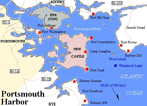
�� Fort Foster (2) (Park)
(1873 - 1948), near Kittery Point
Located on Gerrish Island. Battery on Gerrish's Island was built here in 1874 but was never finished. Coastal batteries here were Battery Bohlen (1901 - 1942) partially buried, Battery Chapin (1904 - 1945),
Battery 205 (1944), and Anti Motor Torpedo Boat Battery 952 (1943 - 1946) partially buried.
An observation and radar tower was built in 1943 on Appledore Island, part of the Isles of Shoals just offshore from here. It is on the campus of Cornell
University's Shoals Marine Lab. There is another tower nearby, located on Sister's Point on the northeastern shore of Gerrish Island. Fort Foster was used briefly by the Navy as a recreation area in the 1950's. Admission fee.
�� Fort McClary
(State Historic Site)
(1808-1918), Kittery Point 
There was a previous fort nearby called Fort Pepperrell (also known as
Pepperrell's Fort) and it dates back to 1680. Later came the six-gun
Fort William from 1720 to 1779. In 1808, Fort McClary was only a simple
stone battery and earthworks. The blockhouse, the last one built in this state, was built in 1845. During the Civil War, a granite fortress with a caponier and two bastions was started around the blockhouse, and it was to resemble Forts Knox and Popham. The fort had up to 10 guns. It was abandoned in 1868. Three cannon were left here for the Spanish-American War. In World War I, the fort was used as an observation post. Two American Revolution-era batteries were built just to the west of here. Admission fee.
�� ALSO: Additional observation towers in Maine associated with the Portsmouth Harbor Defenses were located at Gelaspus Point (Kennebunkport) (no remains), Moody Beach (still there), Bald Head Cliff (destroyed 1964), Cape Neddick (still there), and Seal Head Point (destroyed 1960's).
Fort Sullivan (2)
(1775 - 1865, intermittent),
Portsmouth Naval Shipyard
An earthworks fort once located on the southern end of Seavey's Island (near where the abandoned Naval prison now sits at Sullivan Point) from 1775 to 1815, and again from 1861 to 1865 as an 11-gun 8-inch Rodman naval battery, manned by Negro sailors who were training at the Shipyard. Another battery was built just to the west of here, on Henderson's Point, during the Revolution. Fortifications were put up on what was once Dennett's Island from 1801 to the 1840's. Established in 1898 on Seavey's Island was Camp Long, a Spanish POW camp, and Camp Heyward, a USMC camp. The Portsmouth Naval Prison was built on the site of Camp Long.
History of
Portsmouth Naval Shipyard
Kittery Garrison Houses
(1665, 1710, 1720 - 1722), Kittery
In 1722 there were 30 (36 authorized) of these fortified houses but only three remain, Whipple Garrison (aka Cutt Garrison) (1665) on Whipple Road, Dennett Garrison (1710) on Dennett Road, and Mitchell Garrison (1665) on Mitchell Lane in Kittery Point. These three are still private residences but
the Mitchell house no longer has the garrison characteristics. Another garrison house from 1720 was the Newmarch Garrison. Other garrison houses in 1690 included Morrell, Shapleigh, Hammond, Tutherly, Fernald, Alcott, Curtis, Wilson, Pepperrell, (see Fort McClary above) and Champernowne Garrisons.
Frank's Fort
(1631 - unknown), Eliot
Located on Frankfort Island in the Piscataqua River, upstream from Kittery and Portsmouth. It was built by the Laconia Company for the protection and shelter of company employees in the salt industry project. It was a failure and did not last long.
Eliot Garrison Houses
(1650's, 1690's), Eliot
Once located here were Watt's Fort (1650's) located one mile upriver from Frankfort Island, also known as Jocelyn's Fort (1); Darby's Fort (1650's); and Leighton's Fort (1690). Located on Frost's Hill is the Frost Garrison (2) (1730's ?), a fortified barn.
Berwick Garrison Houses
(1675, 1680's), Berwick
Once a part of Kittery. Destroyed in 1675 during King Philip's War were Tozer Garrison (aka Old Garrison House torn down in 1850's), located one mile from Salmon Falls, NH across the river, on Route 236 half a mile from the railroad, and Plaisted Garrison, located by the railroad on Route 236. The present-day houses at those sites were built on the original foundations. Also located here in 1675 was Gerrish's Blockhouse and Goodwin's Blockhouse, upriver from Gerrish's. Located here in 1690 were the Frost (1), Hodgedon, John Mason, Richard Mason, Stone, Abbott, Spencer, and Holmes Garrisons. Located on Pine Hill was Hamilton's Garrison (aka Pine Hill Fort) (unknown date). It was still in existence in 1750.
Northern Maine - page 1
 Books about Forts in Maine