Click on thumbnail image or highlighted text for a larger picture.
Table of Contents |
Quick Index: |
17th century |
18th century | 19th century | 20th century | Architecture links | Fine Arts department home page
Boston: History of the Landfills
Click on any picture for an enlarged version.
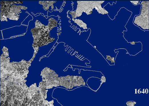
 A diagram of the sequence of landfill projects illustrates the pattern in which the city grew. The west cove and the Mill Pond were the first to be filled in during the early 19th century, followed by the South Cove, East Cove, and South Boston, which began to be filled in 1836. The South Bay was filled following 1850.
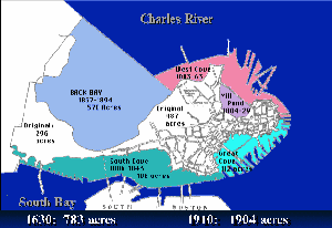
The Back Bay was filled in from 1857 to 1894, with Charlestown and the Fenway area beginning to be filled shortly later. The last quarter of the century saw new projects begun in East Boston, Marine Park and Columbus Park to the south. The area which became Logan airport began to be filled in 1922.
Each project added to Boston, but the filling of the Back Bay was the largest single project.
The initial alteration to the Back Bay was the creation in 1814 of a long dam, known as the Mill Dam, which extended from Brookline to the edge of the Boston Common. Intended to harness the power of the tides, the project was a failure as a source of power. By the mid 1830s, the area behind the dam was further subdivided by newly constructed railroad beds which criss-crossed the bay.
The Mill Dam was a popular promenade, and ultimately became the foundation of Beacon Street. The blocking of the bay by these constructions created vast reservoirs of stagnant water, made less appealing by the addition of raw sewage. The environmental impact of these projects was not well understood. The condition of the bay was a serious problem, and added incentive to the move to fill in this area as well. The hunger for new land was more intense than ever at mid-century.
Photographs from the late 1850s, taken from the State House on Beacon Hill, shows that the landfill had made very little progress as yet. The Bay is still mostly water, and the train crossing areas are still visible at the upper left.
Boston at mid century was a thriving metropolis, beginning to burst its narrow confines of the original terrain. Boston Common, which had been a fixture since the 17th century, was well established, but the public garden was hardly begun at this time. Beacon Street was just being developed, and a railroad station occupied a prominent position at the south edge of the Common, on the right. The modern city of Boston emerged from the waters, an Atlantis in reverse.
 New technologies were required for the filling of the Back Bay. It was a larger area to be filled -- more than 700 acres -- and the easy sources of fill were already cut down. The invention of the railroad and steam shovel made it possible to bring in gravel from as far away as Needham to the West. It was a tremendous undertaking, and carefully organized. At the peak of activity, 3,500 carloads per day were sent from the Needham gravel pits to be dumped in the Back Bay. The main entrepreneur in this venture was John Souther.
A map of Boston in 1862 shows the progress of the landfill; the criss-cross created by the railroad lines has been nearly half filled in, only 5 years after the project began. By the early 1880s, the main outlines of the Back Bay were nearly completed. One can see the modern thicker midsection of Boston taking shape.
Commonwealth avenue was laid out in imitation of recent French Boulevards constructed by Baron Haussmann in Paris. 200 feet wide, the avenue had generous median strips of grass and trees. One can see the few isolated houses which are beginning to be constructed. This photograph was taken from the tower of the then new Brattle Square Church by H.H. Richardson, and shows the crossing of Dartmouth Street. This same church is still a landmark today, although the rest of the street is much changed.
The Back Bay became a center for cultural institutions as well as fashionable residences. Copley Square was developed in the 1870s, first with Richardson's Trinity Church, and followed by the New Old South Church, the Museum of Fine Arts, and the Boston Public Library, constructed by McKim Mead and White, beginning in 1888. Adjacent to Trinity Church and the Public Library was the original building for the Museum of Fine Arts, erected in 1877 by the architects William Ware and Henry van Brunt. Constructed in a vibrant Victorian Gothic style, the building lasted only a little over 30 years before it was replaced. The site is now occupied by the Copley Plaza Hotel.
In 1907, the Museum of Fine Arts migrated further west on Huntington Street, to a new building in the Fenway area. This new building reflected the triumph of academic classicism in Boston. Following the success of the Public Library, classical architecture dominated in Boston, and replaced the spiky, irregular Victorian Gothic architecture.
The Fenway itself was a beautiful jewel in the "Emerald Necklace" of parks created by Frederick Law Olmstead to ring Boston. In its move to the Fenway, the Museum of Fine Arts followed such eminent and art conscious citizens as Isabella Stewart Gardner, who built her home and museum in this area as early as 1900.
An extraordinary amount of effort was expended to transform the landscape of Boston. Powerful forces contributed to make all of this activity happen. The great increase of population in the 19th century in Boston made the creation of new land imperative. The accompanying increase in land values made these ventures profitable, and the development of new technologies in the 19th century made it possible to alter the landscape on such a scale.
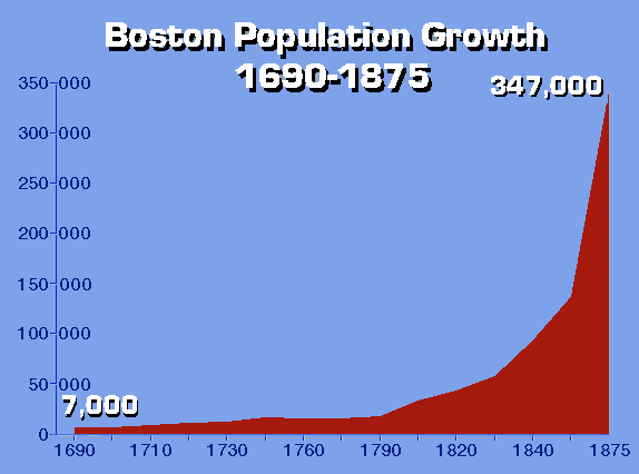
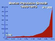 The population of Boston was still small in 1790, being only about 18,000 people. Immigration in the 19th century brought unprecedented growth. By 1875, 347,000 persons lived in Boston.
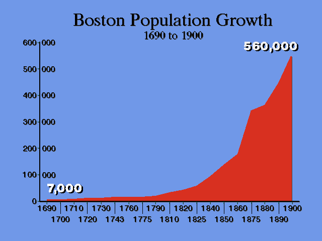
 Graph of Boston Population to 1900
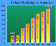
These same factors which encouraged the landfill of Boston, likewise encouraged builders to create ever taller buildings all over America. One can see a similar progression in the heights of the tallest buildings in America in the last two centuries. In 1846, the tallest building in the United States was Trinity Church in New York, with a height of 284 feet. By 1913, the Woolworth Building had attained to 55 stories in height, and was itself outdone by the Chrysler and Empire State Buildings in the 1930s. The World Trade Center reached 100 stories in 1971, and in 1974, the Sears Tower was built at 110 stories, or 1,454 feet.
 Boston also saw the rise of skyscrapers in the 19th century. The Ames Building was for some time the tallest building in Boston. Designed by Shepley, Rutan and Coolidge, it was both a sign of the future and a holdover from the past. Built with traditional "bearing wall" masonry construction, the lower walls had to be 9 feet thick to achieve the height of 13 stories. Later tall buildings would use steel framing and interior skeleton "skyscraper" construction, requiring less material and weighing much less. This was important in an area where much of the city was landfill.
Trinity Church and the John Hancock building reflect the contrast of building techniques. The great mass of the solid stone of Trinity Church was of concern to the builders of the church, and H.H. Richardson ultimately reduced the height of the tower to reduce the weight. The John Hancock Building of 100 years later utilizes a light skeleton of metal which allows soaring height and an elegant curtain wall of glass.
 The original profile of Boston remains beneath the surface of the modern city. When one realizes the dimensions of the changes enacted upon this site, one is filled with a new appreciation for the achievement of earlier centuries. The landfill projects in Boston filled in the bays and smoothed out the irregularities of the Shawmut peninsula. The historical sequence of landfill projects in Boston also helps explain some of the peculiarities of the modern urban landscape. Boston streets, laid out in the 17th and 18th century, followed a coastline which has moved and avoided hills which are no longer there. One can safely dismiss the myth that the tangled patterns of Boston streets were established by colonial cowpaths.
Boston Landfill -- Page 1
Boston Landfill -- Page 2
Slide Show, part 1
17th century |
Slide Show, part 2
18th century |
Slide Show, part 3
1790-1820 |
Slide Show, part 4
1820s |
Slide Show, part 5
Quincy Market, 1820s |
Slide Show, part 6
The Back Bay, part 1 |
Slide Show, part 7
The Back Bay, part 2 |
Slide Show, part 8
1870-1890:
The South End |
Slide Show, part 9
1872 Fire |
|
|
|
Boston Population
Growth |
LandFill Sequence |
The Big Dig:
1990s |
|
Choose a century or other category from the tables below:
 Other Art and Architecture Web Links

Boston College Fine Arts Department Home Page
Boston College
Jeffery Howe, 1996
>
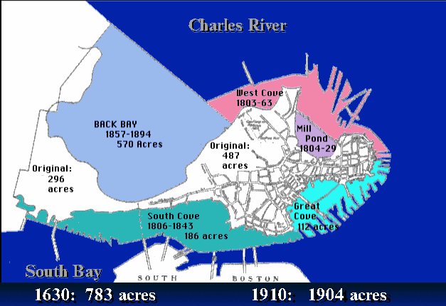 A diagram of the sequence of landfill projects illustrates the pattern in which the city grew. The west cove and the Mill Pond were the first to be filled in during the early 19th century, followed by the South Cove, East Cove, and South Boston, which began to be filled in 1836. The South Bay was filled following 1850.
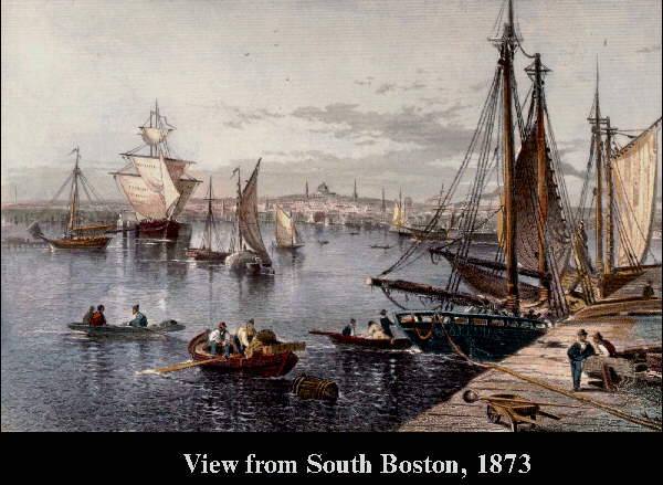
 Graph of Boston Population to 1900