The Eastern part
of the Western Front:
The Vosges and Alsace,
A travel Guide (part 2) updated
2008
Sentier du Bunkers (Burnhaupt-le-Bas), Col. St. Marie, Grandfontaine-le-Donon, Le Petit Donon, Artillery positions lEtoile, La Corbeille
Introduction
Having spend 5 very interesting days in the Vosges in
2000 (see travel guide part 1) it was high
time to visit this part of the front again.
The opportunity came when we had to return from Italy through Switzerland
in 2006 which brought us to Mulhouse. We spend one day in Mulhouse and two
in St. Die. We did it all at leisure and can image that you can do the
items below in two days.
Our friend Eric Mansuy, who we first meet in 2000, suggested
three routes for us and was our guide for one of these. Again we owe
thanks to Eric for his time, knowledge and last but not least his friendship.
For this tour two IGN (1:100.000) are needed: IGN #31 St. Die - Mulhouse
and #12 Strasbourg - Forbach. It is of course also possible to add the
items below to the tour described in part 1.
Word
of Warning
For walking in forested hills the normal precautions should be taken: good
shoes, watch out for thunder storms which can sneak up on you (as happened
to us). Get off a hill as quickly as you can or shelter in one of the many
German bunkers.
No matter how warm it is: wear long sleeves, long trousers and wear your
socks over your trousers. Ticks which can cause Lime's disease are
plentiful out here. One of us did not follow this advice in 2008 (short
sleeves and trousers not in socks) ended up with two ticks, one on his leg
and one in the arm-pit. The penalty being a doctors visit and 14 days
antibiotics.
History
For this item we refer you to part
1 of the travel guide.
1: Sentier du
Bunkers, Burnhaupt-le-Bas
From Mulhouse take the A36 in the direction of Paris. Leave at exit 15 and
park at the church of Burnhaupt-le-Bas. From here and
interesting walking route starts of 8,6 km called 'Sentier des Bunkers'
which leads you to several interesting vestiges of the Great War. The
route can be followed on this website: http://burnhaupt.free.fr/bunkers/index.html
(French and German). It is recommended to print the map from the website
since it can be handy when you follow the route. In the village itself remember
that the French way of directions is 'no sign = follow the road even if it
makes a turn and there is a possibility to go straight ahead'.
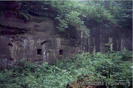
After the first battles of 1914 and despite French efforts in 1915 the front in this area remained rather static and ran from Cernay to Dannemarie. Burnhaupt-le-Bas was behind the German lines but was under regular French gunfire which resulted in the evacuation of the civilian population in 1915. The bunkers that are visited today are a second line of defense constructed by the Germans from end 1916 through 1917.
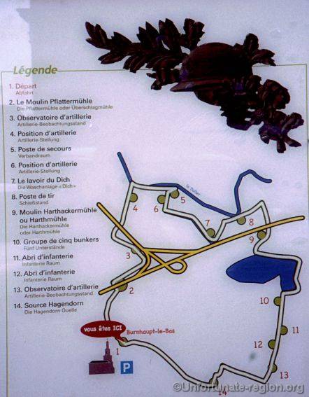 |
Sentier du Bunkers - Burnhaupt-le-Bas
 |
Artillery position (4)
 |
First Aid Station (5)
 |
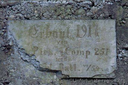
Inscription on bunker
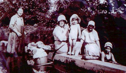 |
Washing ditch (7) then
Constructed before the French revolution and used till 1960
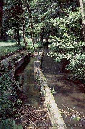 |
Washing ditch (7) now
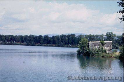 |
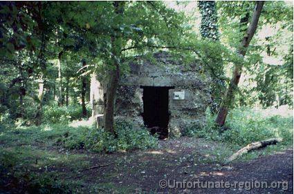
Bunker at lake
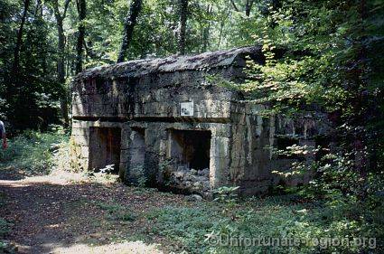 |
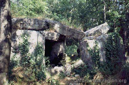
Position of five bunkers (10) comprises men shelters (see picture)
and munitions storage bunkers.
 |
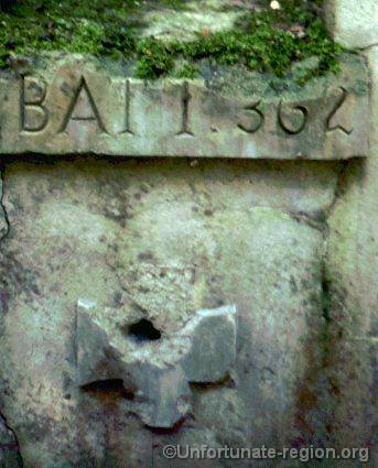
Inscription on infantry bunker
 |
Artillery observation position on top of bunker
If you have not visited this region before we suggest to visit other sites in the area mentioned in part 1 of this travel guide to fill the remainder of the day or you can head straight to the next site.
From Burnhaupt-le-Bas take the A36 and then the A35 in the direction of Strasbourg. Leave the A35 at junction 17 Selestat and take the N59 to St. Marie-aux-Mines. In St. Marie-aux-Mines do not take the tunnel but follow the N59 to Col. de St. Marie. Park at the sign for the French Military Cemetery.
2: Col. St. Marie
It it clear that this was a strategic area for any west to east (or
visa versa) movement. Col. St. Marie was the sight of heavy fighting in
1914, 1918 and 1940. There are two memorials to individuals (1914 and
1940), a military cemetery and a German bunker.
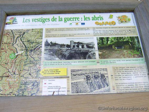 |
Explanation sign
On July 31, 1914, at 3 o'clock in the morning German Uhlans and artillery batteries appear at St. Marie-aux-Mines but they leave again only to re-appear and firmly occupy the city when the French occupy the Col. St. Marie in August. The city is used as a base for the attacks on the surrounding mountains, which makes the city a prime target for French artillery. From November 1914 to November 1918 the front doesn't change much with the French on the top of Bernardstein and of Violu, and the Germans holding the slopes firmly.
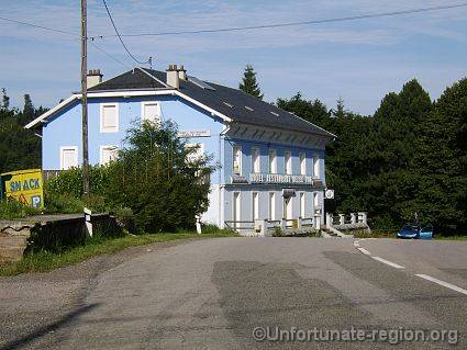 |
Hotel Belle Vue 2008
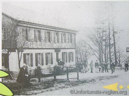 |
Hotel Belle Vue 1914
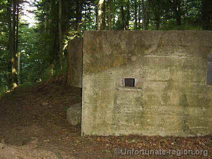 |
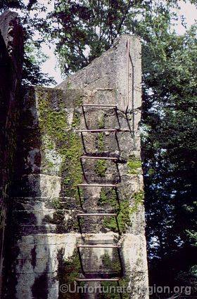
German bunker on Col. St. Marie
 |
German bunker on Col. St. Marie
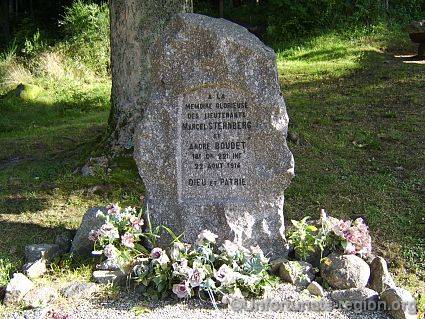 |
Memorial to Lt Sternberg and Boudet, 18 Comp. 221 R.I. 22 August 1914
Continue on the N59 to St. Die where it is recommended you stay the night.
3:
Grandfontaine-le-Donon
From St. Die take the N59 to Raon-l'Etape and
from there the D392 in the direction of Schirmeck. Park at the French
military cemetery of Grandfontaine-le-Donon, opposite the restaurant.
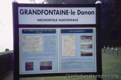 |
Explanation sign at Grandfontain-du-Donon Necropole Nationale
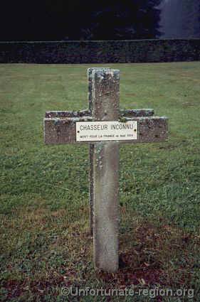 |
Unknown French Chasseur killed August 1914
(see the stones on Le Petit Donon below)
An sign in the cemetery explains how on 21-22 August 1914 French (mainly of the 21st Bn. Chasseurs a Pied) and German forces clashed on the Petit Donon. It also tells how in this region the first German Regimental flag was captured by the French and how it was proudly displayed in Paris. Research by our guide Eric Mansuy using contemporary letters in the possession of relatives of the soldiers involved show that the true story is slightly different. Some of the German soldiers involved were from Alsace / Loraine themselves and considered themselves more French then German. Many of these troops took the first opportunity to surrender. One of these soldiers told his French capturers that he was the flag barer and that he had hidden 'that bloody German flag' on a nearby farm and that he would gladly show where it was. This is how the first German Regimental flag was 'captured'....
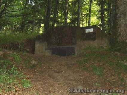
Follow the path on the right of the cemetery into the forest. Here two large German concrete structures can be found close to each other: an artillery position and a command center.
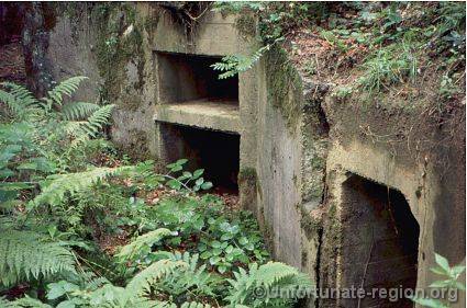 |
Artillery position at Grandfontain-du-Donon
 |
Open Artillery position at Grandfontain-du-Donon
 |
Command center at Grandfontain-du-Donon
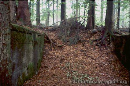
4: The open cemetery
of Le Petit Donon
Get back to your car, right onto the D392 and turn left unto the
D393. After 1,5 km turn left onto the D145 and immediately turn right onto
an unmarked road which will take you to a parking and picnic site. From
here you can walk up the Petit Donon. It can be easy recognized because it
is stripped of all its trees by the 1990's hurricane that past through.
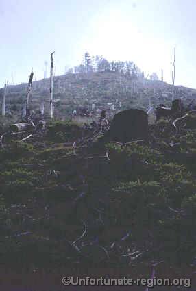 |
The bare summit of Le Petit Donon 2006
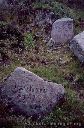
The whole hill is littered with stones that have a number on them and commemorate different numbers of Unknown French or German soldiers. From the memorial on top we know if was a Gefreiter (Private) Gerhardt who made these inscriptions. The photo below shows two stones in sequence (No's 33 and 34) but usually there is no logical sequence. There are stones that have tumbled down the mountain over the years or fell over hiding their inscribed side. Research in archives by people researching this site has to date not brought a map to light. It is also unknown if the unknowns are still buried on the site or if they were removed during or after the war.
 |
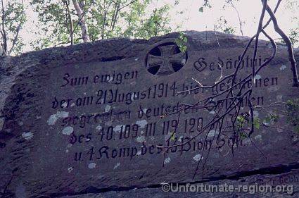
Former(?) cemetery of Le Petit Donon
 |
Memorial made by Gefreiter Gerhardt
How we got to the sites mentioned below we can no longer trace (it was a tough vacation) but they can be found on detail maps that can be bought locally.
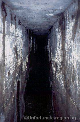
5: Gallery under road
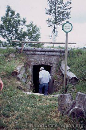 |
Entrance to underground gallery passing under modern road
Col de la Cote de l'Engin
6: Artillery positions at lEtoile
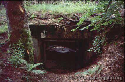 |
Covered Artillery position at lEtoile
7: La Corbeille
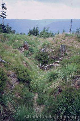 |
Trench remains on La Corbeille
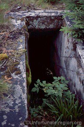 |
La Corbeille: entrance to 76 meters long concrete tunnel
connecting two observation / machine gun positions
 |
La Corbeille: 76 meters long concrete tunnel
An Unfortunate Region 2006/2008